

The Interamna Lirenas Project is an ongoing archaeological fieldwork project aimed at expanding and deepening our knowledge and understanding of the development of the Roman town of Interamna Lirenas (and its territory), from its foundation as a Latin colony in 312 BC until its definitive abandonment towards the end of the sixth century AD (Launaro, Reference Launaro and De Giorgi2019, Reference Launaro and Launaro2023; Launaro and Millett, Reference Launaro and Millett2023). Its ordinary character (suggested by its average size and middling status within the urban settlement hierarchy) and its long-term occupation make it an ideal vantage point from which to observe the local impact of, and response to, the broader transformations affecting this part of Italy specifically — and the Roman world more generally.
Although the urban plan is broadly known thanks to full-coverage geophysical prospection (combining magnetometry and ground-penetrating radar), deeper structures associated with the town’s early phases of occupation appear to have eluded detection. For this reason, we have launched a new phase of excavations (2023–25) explicitly aimed at bringing to light structures and materials specifically associated with the Republican occupation of the site (late fourth to first century BC). The 2024 season built on the results of the previous season (Goddard, Launaro and Leone, Reference Goddard, Launaro and Leone2024) and continued to focus on some sectors of Areas 1000 (the Republican porticus beneath the crypta of the theatre) and 2000 (the footpath located immediately to the northeast of the basilica; the sewer located immediately to the north and perpendicular to it). In parallel, our collaborators from the Associazione Roma Sotterranea continued excavation of the well located beneath the ramp of the southeastern parodos of the theatre (Area 1000).
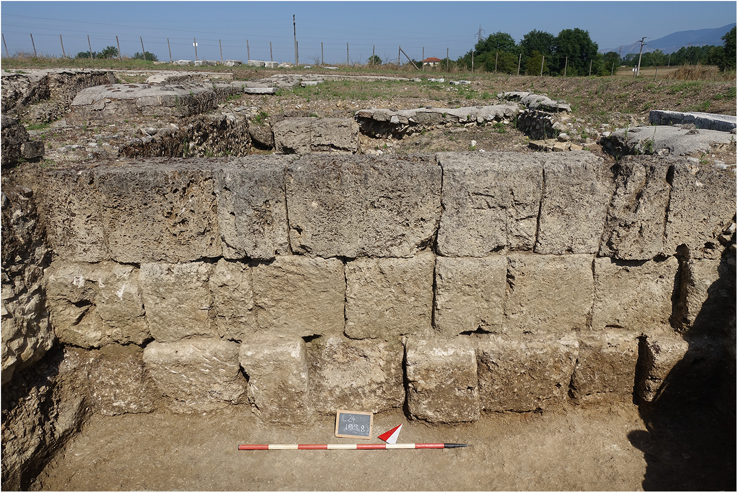
In Area 1000, the excavation of the Republican structures already identified beneath the crypta revealed the external side of the southeastern wall in its entirety (Fig. 1). This segment of the porticus was preserved to a height of c. 1.80 m, in the form of three courses of local travertine blocks (opus quadratum), the lowest of which forms its foundation (as indicated by an offset). This foundation rests on the geological layer (compact clay mixed with small and medium-sized pebbles) and was covered with compact, plastic clay that yielded relatively few finds, all seemingly datable to the Republican period.
view of the southeastern wall of the Republican porticus excavated in Area 1000.

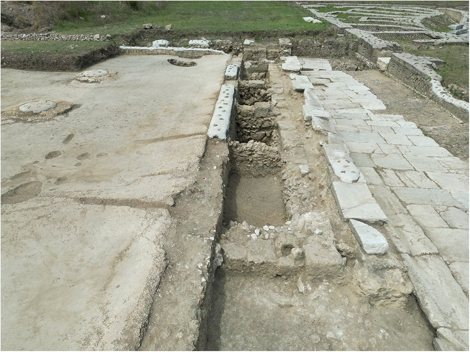
Below the footpath in Area 2000, the structure in local travertine blocks (oriented northwest–southeast), identified during the 2023 season, was exposed in its entirety (approx. 15.4 m). It consists of blocks of local travertine resting on a foundation of medium-sized fragments of local travertine and river stones bonded with clay, which in turn rests on the geological layer (alluvial layer of compact clay mixed with small and medium-sized pebbles). Five other structures abut perpendicularly to this structure (northeast–southwest orientation; cut by the foundation of the basilica). Except for the two at either end (in large travertine blocks), they are mostly made up of medium-sized fragments of local travertine and river stones bound with clay, resting on the geological layer mentioned above (Fig. 2). Beneath the floor of the basilica, in connection with the large hole already identified in the 2022 season, we found a well (built with dry stones) and a section of a structure in travertine blocks and parallel to the one beneath the footpath. All these elements probably belong to a building constructed in the Republican period, later razed to make way for the basilica that now covers it. If so, the perpendicular structures made with large fragments of local travertine and river stones bound with clay may represent the foundations and the plinths of walls dividing the building’s internal spaces. This could indicate the presence of rooms whose function (domestic or commercial) is yet to be confirmed, but which seem difficult to reconcile with the supposed existence of an earlier Republican basilica (Goddard at al., Reference Goddard, Launaro, Leone, Millett and Pantano2022: 345–6; Goddard, Launaro and Leone, Reference Goddard, Launaro and Leone2023: 337). The excavation of this sector also made it possible to confirm the depth (210 cm) of the basilica’s northeastern foundations in opus caementicium, and of the basilica’s northeastern side, the cut of which reaches the same geological layer mentioned above.
view of the excavation in Area 2000, looking northwestwards (basilica on the left, Street E on the right).

As for the sewer within Area 2000, excavation of the section between the edge of the footpath and the theatre’s foundation has been completed. This revealed the existence of at least two Republican construction phases — an earlier one (blocks of local travertine) covered by a more recent one (opus incertum) — whose absolute chronology is still being established. This structure rests on the impermeable geological layer, which appears to have served as the bottom of the drain.
Finally, the exploration of the well beneath the ramp of the theatre’s southeastern parodos, conducted by volunteers from the Roma Sotterranea Association, reached a depth of 5 m. Excavation proceeded through thick layers of incoherent material (stone, building material, ceramic fragments, large animal bones), probably resulting from the accumulation of debris and rubble following the abandonment of the theatre.
Acknowledgements
The Interamna Lirenas Project is a partnership between the Faculty of Classics of the University of Cambridge, the Soprintendenza Archeologia, Belle Arti e Paesaggio per le Province di Frosinone e Latina, the Comune di Pignataro Interamna and the British School at Rome, and involves a collaboration with the Associazione Roma Sotterranea.

 Open access