


Introduction
Ecological corridors are essential for maintaining biodiversity by allowing gene flow between wildlife populations (Hilty et al., Reference Hilty, Keeley, Lidicker and Merenlender2019). Corridors are designed under the premise that connecting habitat fragments reduces extinction risks, inbreeding and landscape vulnerability (Hilty et al., Reference Hilty, Keeley, Lidicker and Merenlender2019). Their success is not determined solely by their ecological and physical structure but also by the human dimensions they encompass. The relationship between people and wildlife plays a critical role in how these corridors function (Ghoddousi et al., Reference Ghoddousi, Buchholtz, Dietsch, Williamson, Sharma and Balkenhol2021). Understanding and addressing human–wildlife interactions (e.g. the acceptance of wildlife) is crucial to achieving the long-term goals of biodiversity conservation and social justice within these shared landscapes (Ferraz et al., Reference Ferraz, de, Bento, de, Di Souza, Nunes, Guimarães and Pereira2025). This link between ecological and human dimensions in corridor effectiveness, however, remains underexplored.
Baird’s tapir Tapirus bairdii, categorized as Endangered on the IUCN Red List (García et al., Reference García, Jordan, O’Farril, Poot, Meyer and Estrada2016), inhabits diverse habitats from southern Mexico to northern Colombia (Reyna-Hurtado et al., Reference Reyna-Hurtado, Meyer, Huerta- Rodríguez, Martínez-Martínez, Pérez-Flores and Rivero2024). As a generalist herbivore, this species has a strong preference for environments with abundant water bodies and forests with a dense understorey (Foerster & Vaughan, Reference Foerster and Vaughan2015; Reyna-Hurtado et al., Reference Reyna-Hurtado, Meyer, Huerta- Rodríguez, Martínez-Martínez, Pérez-Flores and Rivero2024). Despite these natural habitat preferences, the tapir is increasingly found on private lands adjacent to protected areas, which offer secondary forests and agricultural crops (Cove et al., Reference Cove, Vargas, De La Cruz, Spínola, Jackson, Saénz and Chassot2014). This shifting pattern of habitat use is particularly evident in the Tenorio–Miravalles Biological Corridor in Costa Rica, a shared rural landscape.
The main role of the Tenorio–Miravalles Biological Corridor is to maintain ecological connectivity between two national parks, with the tapir chosen as an umbrella species to guide conservation efforts (Bautista-Solís et al., Reference Bautista-Solís, Gutiérrez-Montes, Aguilar, Cotto, Gómez and González2012). The umbrella species concept suggests that conserving species with large distribution areas protects co-occurring species (Roberge & Angelstam, Reference Roberge and Angelstam2004). Baird’s tapir is suitable for this purpose because of its broad habitat requirements and its role as a seed disperser, promoting gene flow in plant populations and aiding forest regeneration (Mendoza et al., Reference Mendoza, Godínez-Gómez, Delgado-Martínez and Camargo-Sanabria2024). From 2015 to 2020, authorities recorded an increase in reports of encounters between tapirs and people within this corridor (E. Brenes-Mora, pers. obs., 2020).
The extent to which local communities accept wildlife influences the effectiveness of ecological corridors in shared landscapes (Ghoddousi et al., Reference Ghoddousi, Buchholtz, Dietsch, Williamson, Sharma and Balkenhol2021). Here we use the wildlife acceptance model, in which acceptance refers to a person’s willingness to tolerate the presence of wildlife individuals or populations, in this case tapirs, in a specific context without the need to take action to control, reduce, deter, harm or eliminate them (Decker & Purdy, Reference Decker and Purdy1988; Bruskotter & Fulton, Reference Bruskotter and Fulton2012). Accepting wildlife presence, according to hazard–acceptance model theory, is driven by risk perceptions, benefit perceptions and social trust (Bruskotter & Wilson, Reference Bruskotter and Wilson2014).
We explore the relationship between the acceptance of wildlife and habitat connectivity within the Tenorio–Miravalles Biological Corridor by (1) modelling the least-cost routes for the movement of Baird’s tapirs within the corridor landscape, thereby identifying priority areas for managing human–wildlife interactions, and (2) characterizing the acceptance of landowners and land managers of the presence and movement of Baird’s tapirs on their properties within the corridor’s prioritized routes. This approach extends beyond structural and ecological connectivity by addressing the socioeconomic factors that influence wildlife movement, which must be managed to enhance the functionality of ecological corridors.
Study area
The research was conducted in the 12,503 ha Tenorio–Miravalles Biological Corridor in north-west Costa Rica (Fig. 1) during November 2019–October 2022. The corridor spans the Caribbean and Pacific slopes over altitudes of 400–700 m. It features primary forests, numerous water bodies, and comprises tropical wet forest, premontane wet forest and premontane rainforest. Total annual rainfall is 2,500–4,500 mm, with mean annual temperatures of 22–26 °C. (SINAC, 2013, 2017). Land use in the corridor is diverse; it connects Tenorio and Miravalles Jorge Manuel Dengo Volcano National Parks, which are 4 km apart at their closest point, through a landscape dominated by small, private properties. The region has 16 towns, where livelihoods are based on agriculture, livestock and tourism-related activities, creating a mosaic of productive and conservation lands (Bautista-Solís et al., Reference Bautista-Solís, Gutiérrez-Montes, Aguilar, Cotto, Gómez and González2012; Catie et al., 2017).
Location of the Tenorio–Miravalles Biological Corridor in Costa Rica, showing its position between the Tenorio and Miravalles Jorge Manuel Dengo Volcano National Parks.

Methods
Modelling landscape connectivity resistance
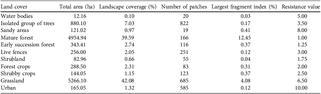
To model least-cost routes for tapir movement within the corridor, we used a raster image from the Nai conservation database (unpubl. private dataset, 2020) that is categorized by 11 land-cover types (Table 1). This image was converted into a resistance layer using the packages grainscape (Etherington & Holland, Reference Etherington and Holland2013), raster (Hijmans, Reference Hijmans2023) and gdistance (van Etten, Reference van Etten2017) in R 3.6.1 (R Core Team, 2019). Resistance values of 1–10 were assigned to each pixel, where 1 represents low resistance and 10 indicates high resistance to tapir movement. These values were based on expert opinion on tapir habitat preferences and aligned with standard resistance mapping methodologies (Zeller et al., Reference Zeller, McGarigal and Whiteley2012). This process involved consultation with three regional Baird’s tapir specialists, each with > 8 years of field experience in Central America. They ranked land-cover types based on their known influence on tapir movement, and this was subsequently cross-referenced with a literature review of T. bairdii habitat use and movement behaviour. Forested areas were assigned low resistance values because of their suitability as tapir habitat, as they closely resemble the species’ natural environment and are more likely to fulfill its resource requirements (Zeller et al., Reference Zeller, Compton, Finn and Palm2024). Urban areas were assigned high resistance values because they act as barriers to tapir movement (Schank et al., Reference Schank, Cove, Arima, Brandt, Brenes-Mora and Carver2020). The size and number of forest patches were then calculated, and importance values for connectivity were calculated by evaluating how many neighboring patches each patch connected with. The least-cost route between forest patches in the northern and southern sectors of both Tenorio and Miravalles National Parks were generated by calculating the cumulative cost of movement between patches using a transition matrix that accounts for the resistance values of adjacent cells, identifying the path with the lowest total resistance. A movement threshold of 1 km was assumed, representing the maximum distance a tapir is expected to travel through a high-resistance matrix between suitable patches. With a resolution of 10 × 10 m per pixel, the 1 km threshold corresponds to a distance of 100 pixels. This threshold was based on documented home ranges for Baird’s tapir in Costa Rica of 0.94–15.97 km2 (Reyna-Hurtado et al., Reference Reyna-Hurtado, Meyer, Huerta- Rodríguez, Martínez-Martínez, Pérez-Flores and Rivero2024). Using QGIS 3.14 (QGIS, 2026), the shape file for Costa Rican towns (Sistema Nacional de Información Territorial, Reference Nacional de Información Territorial2018) was overlain on the corridor layer to identify towns closest (1–4 km) to the least-cost connectivity routes. These towns were verified to confirm current land-use boundaries using Google Earth Pro (Google, Mountain View, USA) and later through field inspections.
The 11 land-cover types in the Tenorio–Miravalles Biological Corridor in north-west Costa Rica (Fig. 1), with the area, per cent of total area, number of patches, fragment index of the largest patch and resistance value (see text for details).

To characterize the matrix of the Tenorio–Miravalles Biological Corridor, we quantified four primary landscape metrics (Table 1) for each land-cover type using LecoS 3.0.0 in QGIS. Total area (ha) and landscape coverage (%) were calculated to identify the dominant land-use types within the corridor. These metrics provide a baseline for the availability of the land-cover types through which tapirs must navigate. The number of patches was used as an indicator of fragmentation; a high number of patches for a specific land cover type (e.g. forest) indicates a highly dissected landscape, whereas a low number suggests a more continuous and connected habitat. We calculated the fragment index of the largest patch to determine its dominance in each land-cover type relative to the total area of the corridor. This is a critical measure for identifying core habitat areas; a high largest fragment index for forest indicates a strong central anchor for wildlife, whereas a low largest fragment index indicates small, isolated fragments, regardless of the total area. Together, these metrics offer a comprehensive baseline for assessing the structural resistance within the ecological corridor.
Acceptance of tapir presence and movement on private land
We explored the relationship between the components of the wildlife acceptance model (Fig. 2) and perceptions of tapir presence and movement through in-depth, face-to-face, semi-structured interviews, conducted in Spanish, during November 2019–November 2021. The semi-structured format enabled us to delve into participants’ experiences and perceptions while maintaining consistency in addressing key components of wildlife acceptance. The interview guide (Supplementary Material 1) included open-ended questions that encouraged participants to share their thoughts and experiences related to tapir movement and presence on private land. Although the guide did not explicitly frame questions around perceived costs/benefits (e.g. economic losses or gains, ecological value), perceived control (e.g. ability to manage interactions with tapirs), affective responses (e.g. fear, appreciation) or trust in institutions (e.g. opinions on conservation policies and enforcement), it encouraged detailed responses that provided insight into the components of wildlife acceptance. The questions were validated by three specialists in human–wildlife relationships and psychology. The interview guide then underwent cognitive testing, by administering it to a small group of individuals to identify any potential misinterpretations or confusing phrasing. This testing was conducted with secondary informants, comprising local community leaders and residents not included in the full study, to ensure clarity, consistency and local relevance (Adcock & Collier, Reference Adcock and Collier2001). The interviewer (author SPP, a biologist with experience in social science methodologies) followed a standardized protocol using neutral language and avoiding leading questions. Ethical standards were upheld and confidentiality was ensured by using an informed consent protocol and form; all participants were provided with a written form explaining the study’s purpose and signed it voluntarily prior to the commencement of the interview. Data collection continued until saturation was reached, meaning no new themes or ideas emerged (Boyce, Reference Boyce2006).
Conceptual model (adapted from Bruskotter & Wilson, Reference Bruskotter and Wilson2014) of factors influencing the acceptance of Baird’s tapir Tapirus bairdii presence and movement on private land in the Tenorio–Miravalles Biological Corridor. This model highlights the interplay of direct effects (solid arrows) and moderated relationships (dotted arrow) in components of acceptance.

Participant selection and recruitment
Our focus was on landowners and land managers as key decision-makers on day-to-day human–wildlife interactions within the Tenorio–Miravalles Biological Corridor, with the following criteria: owning or managing a property within the corridor for at least 1 year, > 18 years of age, engaging in productive activities on their land, and reporting at least one interaction (direct or indirect) with tapirs during 2014–2021. If possible, these interactions were confirmed during field validation, through either direct or indirect evidence of tapir presence. To recruit interviewees, we asked at every other house for people matching this profile. These individuals served as informants for snowball sampling by providing details of potential interviewees.
Data collection and analysis
The interviews were recorded, transcribed and manually coded to identify and classify ideas into emergent themes (Saldana, Reference Saldana2021). Coding was conducted through an iterative review of the transcripts by two independent analysts: author SPP and a volunteer student from the School of Psychology at the University of Costa Rica. The two sets of codes were then compared, and discrepancies were discussed to refine the coding process. We made a separate codification using ChatGTP 4.01 (OpenAI, 2024) in January 2025 following Morgan (Reference Morgan2023) and Hitch (Reference Hitch2024) after training this artificial intelligence tool with the hazard–acceptance model proposed by Bruskotter & Wilson (Reference Bruskotter and Wilson2014). This triangulation helped validate and improve the reliability of the themes identified. Continuous variables were examined using conventional descriptive statistical methods.
Results
Matrix resistance and least-cost routes
The corridor comprises 2,925 patches of 11 land-cover types (Table 1). Grassland and mature forest were the dominant land-cover types (42.08 and 39.59% of the total landscape, respectively). The largest fragment index of mature forest is 12.45%, indicating that the largest continuous block of forest accounts for approximately one-third of the total forested area, with the remainder distributed across 165 patches of forest. The resistance layer (Fig. 3) suggests that the ecological corridor demonstrates good structural connectivity for tapir habitat; 56.90% of the corridor has resistance values ≤ 5, indicating that more than half of the landscape offers apparently favourable conditions for tapir movement. Higher resistance values (6–10) are primarily concentrated in pastures for cattle ranching and urban areas.
Resistance layer for movement of Baird’s tapir T. bairdii through the Tenorio–Miravalles Biological Corridor between the Tenorio and Miravalles Jorge Manuel Dengo Volcano National Parks (Fig. 1), illustrating resistance values assigned to the 11 land-cover types, based on tapir habitat preferences (Table 1).

Although connectivity between the two national parks is maintained by clusters of forest patches in the corridor’s middle section, which are closely spaced with importance values of 5–15 (i.e. connected to 5–15 other forest patches), the most critical individual habitat nodes are in the northern and southern sections (Fig. 4). These northern and southern patches have the highest importance values (15–25), and the least-cost routes for tapir movement originate from these areas (Fig. 5). The northern route spans 5.1 km and the southern route 3.2 km.
Key forest patches for tapir habitat connectivity in the Tenorio–Miravalles Biological Corridor. Importance values represent the degree of connectivity for each patch, specifically the number of neighbouring forest patches (range 5–25) with which an individual patch maintains a functional link. High-importance patches (values 15–25) serve as primary anchors for the corridor.

The two least-cost routes (one each in the north and south) in the Tenorio–Miravalles Biological Corridor, modelled using resistance to tapir movement (Fig. 3, Table 1), to identify optimal pathways for movement between the two national parks, showing habitat patches that lie within each path.

Acceptance of tapir presence and movement
We travelled a total of 30.2 km to conduct interviews for local perspectives on tapir presence. Initially, we approached 52 people who, although they did not meet the interview criteria, recommended 35 potential landowners and land managers, of whom 31 (4 women, 27 men; 14 farmers, eight cattle ranchers and nine tourism operators) agreed to be interviewed. Interviews lasted on average 44.6 ± SD 52.6 min (range 16.5–285.0 min). Data saturation was reached after 19 interviews. Thirty interviewees were permanent residents, and their properties were 1–1,497 ha (mean 66.1 ± SD 47.9 ha, total area 2,048 ha). Through thematic analysis, we identified seven major themes (Table 2), four of which characterize the acceptance components of the hazard-aceptance model regarding tapir movement and presence on private land (Fig. 2)
Summary of thematic analysis, identifying the seven major themes that emerged from the 31 interviews, including key quotes showing participants’ views and experiences related to Baird’s tapir Tapirus bairdii. To preserve anonymity, individual participants are identified with P and a number.

Table 2 Long description
A table with seven rows and four columns. The columns are labeled Theme (Description), Quote, and Who controls whos Strategies for managing the tapir. The rows are labeled with the themes: The tapir is an ally or a challenge, Who controls whos Strategies for managing the tapir, Emotions as flow with the tapirs passage, Institutions managing the tapir, My property is safe full of resources for tapirs, My property is unsafe or restricts tapir movement, and Adaptive behaviour towards tapir presence. Each row contains a description of the theme, a key quote from a participant, and strategies for managing tapir presence. The table provides insights into the participants views and experiences related to Bairds tapir.
The tapir as an ally or a challenge
This theme reflects the perceived risk and benefit dimensions of the model (Fig. 2). Participants expressed varied perceptions of tapir presence. Although 11 of the 31 respondents perceived tapirs as a challenge because of damage to crops (9 respondents) or concerns about the tapirs’ safety and well-being in human-dominated landscapes (2 respondents), 20 participants viewed tapirs to be beneficial either as a tourist attraction or as contributors to ecosystem regeneration. Not all participants who suffered crop damage as a result of tapir presence expressed a perception of risk, and some participants who recognized benefits also expressed a perception of risk. These diverging perspectives underscore the complexity of human–wildlife interactions, influenced by economic activities and environmental values.
Who controls who? Strategies for managing the tapir
This theme represents the control over hazard or benefit dimension of the model, where individuals negotiate their space with the species (Fig. 2). Participants varied in their perceived control over tapir presence and movement. Those who implemented methods such as planting attractive vegetation (7 of 31) or loosening fence wires (5), reported positive outcomes in their interactions with tapirs. Participants who used deterrent methods such as strong-smelling substances (9), cultivating less attractive crops (1) or setting up barriers (5) experienced varying degrees of success, ranging from none to complete effectiveness. These strategies illustrate differing levels of control and ongoing negotiation between people and tapirs.
Emotions that flow with the tapir’s passage
This theme corresponds to the affect dimension of the model (Fig. 2). The emotional connection between participants and tapirs varied widely and was not necessarily linked with perceptions of risk or benefit. Most participants (28 of 31) expressed affection and admiration, considering tapirs as symbols of a healthy forest and community pride. Five participants conveyed frustration or fear, particularly as a result of economic losses or unexpected encounters, and two expressed no emotions towards tapirs. Eleven participants expressed both positive and negative emotions, and two participants specifically expressed concern about tapir presence because of potential unknown risks to tapir health.
Institutions managing the tapir
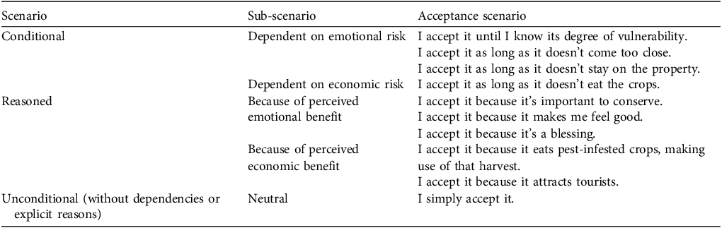
This theme highlights a lack of social trust, a key component in the framework of the hazard-acceptance model (Fig. 2). Twenty-two of the 31 respondents acknowledged the existence of conservation laws protecting wildlife. However, many felt these laws were poorly enforced, leaving them with insufficient institutional support to manage human–tapir interactions. The absence of compensation mechanisms for agricultural losses further contributed to a sense of abandonment and an overload of responsibility. The responses of participants to the question ‘Do you accept, or not, the continued presence and movement of tapirs through your property, and if so, why?’ were categorized into three scenarios, shaped by their perceptions of risks and benefits (Table 3). Eleven participants accepted tapir presence only under specific conditions, when perceptions of emotional and economic risks were reduced. Fourteen participants focused on the perception of economic or emotional benefits of accepting the tapir. Six participants fully accepted the tapir’s presence, viewing it as an integral part of the landscape. None of the 31 participants reported taking retaliatory or harmful actions against the presence or movement of tapirs on their land during the study period. Non-lethal deterrents such as electric fencing were utilized strictly as proactive conflict mitigation strategies.
Acceptance scenarios for tapir presence on private land, showing the different ways in which people accept tapirs, grouped by the conditions or reasons behind their acceptance. The scenarios include emotional, economic and neutral perspectives.

Conditions for tapir presence and movement
Beyond factors influencing acceptance of wildlife (the hazard-acceptance model), the remaining three themes (Table 2) highlighted perceived barriers to and facilitators of tapir presence and movement across private land.
My property is safe and full of resources for tapirs
Twenty-eight of 31 participants identified security, seasonality and resource availability as key drivers of tapir presence. Reduced hunting pressure and seasonal food abundance increased sightings, particularly during September–November when guavas are available, and during December–February, the local rainy season, when tapirs move toward warmer, food-rich areas. Tapirs were most frequently observed near rivers, forest edges and crop fields, where they find the resources they require.
My property is unsafe or restricts tapir movement
Five of 31 respondents, particularly in the southern corridor sector, noted factors that may restrict tapir movement, such as poaching, dogs and infrastructure. In areas where poaching persists, tapirs tend to avoid human settlements. Similarly, dogs were mentioned as a deterrent, as tapirs seem to perceive them as a threat. Physical barriers, such as electric fences, were also cited as obstacles that restrict tapir movement across private land.
Adaptive behaviour towards tapir presence
Landowners and managers exhibited a range of responses to direct or indirect interactions with tapirs, in four categories: recreation, respect, protection or rejection. Some respondents actively tracked tapir footprints, observed them, or took photographs for personal enjoyment. Others showed respect and protection, telling their workers not to disturb them, removing fences to facilitate their passage, or planting guava trees to attract them. However, some people wanted to keep tapirs away from a specific sector of their property; they scared or deterred tapirs by using substances with strong odors (e.g. carboline) or electric fencing.
Discussion
The Tenorio–Miravalles Biological Corridor serves as critical habitat for Baird’s tapirs, offering a structurally connected landscape that supports their movement and resource needs. Large forest patches provide key stepping stones, but their limited size relative to the tapir’s spatial needs underscores the importance of maintaining connectivity to prevent isolation and ensure genetic flow (Naranjo, Reference Naranjo2018; Schank et al., Reference Schank, Cove, Arima, Brandt, Brenes-Mora and Carver2020). The corridor’s widespread vegetation offers abundant resources, including high-quality food, freshwater and shelter, with minimal disturbance (Reyna-Hurtado et al., Reference Reyna-Hurtado, Meyer, Huerta- Rodríguez, Martínez-Martínez, Pérez-Flores and Rivero2024). Secondary vegetation and crops also function as corridors and feeding sites for tapirs (Foerster & Vaughan, Reference Foerster and Vaughan2002; Cove et al., Reference Cove, Vargas, De La Cruz, Spínola, Jackson, Saénz and Chassot2014).
Tapirs are often reported on private lands, most likely taking advantage of crops (Waters, Reference Waters2015). Water bodies on these lands also attract tapirs, and there is a known positive association between tapirs and water availability (Lira et al., Reference Lira, Salas and Sánchez2014; Reyna-Hurtado et al., Reference Reyna-Hurtado, Meyer, Huerta- Rodríguez, Martínez-Martínez, Pérez-Flores and Rivero2024). Proximity to national parks and buffer zones also increases the likelihood of detecting tapirs (Cove et al., Reference Cove, Vargas, De La Cruz, Spínola, Jackson, Saénz and Chassot2014; de la Torre et al., Reference de la Torre, Rivero, Camacho and Álvarez-Márquez2018), although this was not highlighted in interviews.
Although the corridor’s natural features support tapir movement, human attitudes and behaviours also shape connectivity (Ghoddousi et al., Reference Ghoddousi, Buchholtz, Dietsch, Williamson, Sharma and Balkenhol2021). Perceptions influence both short-term attitudes and long-term behaviour (Bruskotter and Wilson, Reference Bruskotter and Wilson2014; Ntuli et al., Reference Ntuli, Jagers, Linell, Sjöstedt and Muchapondwa2019). Our findings show that most landowners and managers recognize the ecological and economic value of tapirs and have adopted measures to facilitate coexistence, such as restoring land and removing fences. These actions enhance connectivity and create safe movement pathways for tapirs (Kindlmann and Burel, Reference Kindlmann and Burel2008; Cushman et al., Reference Cushman, Mcrae, Adriaensen, Beier, Shirley and Zeller2013; Hannah, Reference Hannah and Hannah2015). However, others who perceived tapirs as a risk adopted deterrent practices, mainly to protect crops; this presents challenges to corridor connectivity and affects tapir mobility (Pastor-Parajeles & Bueno Landis, Reference Pastor-Parajeles and Bueno Landis2024). Human actions can either improve or disrupt connectivity in dynamic landscapes (Zeller et al., Reference Zeller, Lewsion, Fletcher, Tulbure and Jennings2020). These effects merit further study using camera traps, telemetry and genetics.
Private land presents both challenges and opportunities for conservation and the connectivity of corridors (Kamal et al., Reference Kamal, Kocór and Grodzińska-Jurczak2015). Crop farming increases the perceived risk of human–tapir interactions because of browsing damage, creating tensions between livelihood protection and conservation goals (Pastor-Parajeles & Bueno Landis, Reference Pastor-Parajeles and Bueno Landis2024). Livestock farming presents indirect threats such as exposure to harmful substances or pathogens (Rojas-Jiménez et al., Reference Rojas-Jiménez, Brenes-Mora, Alcázar-García, Arguedas-Porras and Barquero-Calvo2019). Agricultural land-use change remains a major threat to biodiversity and species movement (Davison et al., Reference Davison, Rahbek and Morueta-Holme2021).
Conservation efforts must work with landowners and managers to increase perceived benefits, promote sustainable practices and explore alternative livelihoods (Frank, Reference Frank2016; Ferraz et al., Reference Ferraz, de, Bento, de, Di Souza, Nunes, Guimarães and Pereira2025). Leveraging perceived benefits can foster greater collaboration and support for conservation efforts, ultimately enhancing corridor connectivity (Frank et al., Reference Frank, Glikman and Marchini2019; Ghoddousi et al., Reference Ghoddousi, Buchholtz, Dietsch, Williamson, Sharma and Balkenhol2021). Tapirs have significant potential as a tourist attraction, offering economic opportunities while fostering biodiversity conservation. However, tourism needs to be managed to avoid disturbing tapir habitat use patterns (Xavier da Silva et al., Reference Xavier da Silva, Paviolo, Tambosi and Pardini2018). Emphasizing the vulnerability and ecological importance of tapirs may further strengthen conservation support, as knowledge often correlates with positive attitudes, but is not necessarily linked to behaviour (Kansky and Knight, Reference Kansky and Knight2014; Bruskotter et al., Reference Bruskotter, Singh, Fulton and Slagle2015).
The success of connectivity routes in the Tenorio–Miravalles Biological Corridor for Baird’s tapirs depend on addressing the social and economic challenges related to coexistence. Combining connectivity spatial models with human dimension components, specifically the psychological and social drivers of acceptance offers a framework for planning and managing wildlife corridors (Ghoddousi et al., Reference Ghoddousi, Buchholtz, Dietsch, Williamson, Sharma and Balkenhol2021). This is especially important in places where human land use and wildlife habitat overlap (Ferraz et al., Reference Ferraz, de, Bento, de, Di Souza, Nunes, Guimarães and Pereira2025). It does not matter how optimal the habitat is if human–wildlife interactions are not managed. Aligning ecological needs with community realities could make the corridor a model for integrating conservation with development.
These findings show that acceptance of tapirs is not a binary decision but rather a spectrum influenced by economics, emotions, land characteristics and institutional support. A lack of social trust in decision-making agencies can lead to resistance to scientific recommendations, increased skepticism toward conservation initiatives, reduced adoption of mitigation strategies and heightened conflict (Volski et al., Reference Volski, McInturff, Gaynor, Yovovich and Brashares2021). Although all participants in our study accepted some level of tapir presence, their motivations and conditions for acceptance varied. Recognizing these nuances is crucial for designing conservation strategies that are both ecologically effective and socially viable, ensuring that human–wildlife coexistence aligns with the socio-economic contexts and practical constraints of landowners and other stakeholders. Understanding these diverse perspectives will facilitate the prioritization of actions that balance wildlife mobility with land-use practices.
This study provides insights into the perceptions and practices of landowners and managers within the Tenorio–Miravalles Biological Corridor, offering a foundation for understanding human–wildlife interactions and serving as a baseline for assessing anthropogenic resistance (social, economic and psychological barriers that hinder animals from moving through a landscape) in ecological corridors. Our research focused on a specific subset of landowners and managers; future studies should include other local stakeholders, to reflect wider perspectives on corridor dynamics. Although our qualitative findings provided contextual insights, incorporating some quantitative indicators would strengthen the study’s overall conclusions. Our study does not directly link the acceptance of wildlife to connectivity within the corridor, but it shows how future research could explore this further to assess the potential effects or impacts of social, economic and psychological drivers on ecological connectivity. Doing so will help build better conservation strategies in this and other ecological corridors.
Supplementary material
The supplementary material for this article is available at doi.org/10.1017/S0030605325102366
Author contributions
Study design: SPP, EBM, RA; fieldwork: SPP, EBM; data collection, analysis: SPP; writing: SPP; revision: SPP, RA, SM, EBM; ethics standards supervision: RA; interview draft validation: SM, RA; study supervision: EBM, RA.
Acknowledgements
We thank Re:wild, The Holtzman Wildlife Foundation and the Society for Conservation Biology for financial support; Sistema Nacional de Areas de Conservación for providing the permits for this research; and the local communities for their help. Academic guidance and support were provided by Hania Vega of the Universidad Nacional de Costa Rica, and Universidad de Costa Rica, and field assistance by Paula Leandro and other colleagues and friends from Nai Conservation.
Conflicts of interest
None.
Ethical standards
Although Universidad Nacional de Costa Rica did not require formal ethical approval, we followed the ethical guidelines set by the university, which align with the Oryx ethical guidelines, ensuring informed consent, strict confidentiality and secure data management. All necessary permits were secured from Sistema Nacional de Areas de Conservación de Costa Rica.
Data availability
The data that support the findings of this study are available from the corresponding author upon reasonable request.





 Open access

