

Introduction
A number of proglacial lakes formed and expanded in temperate valley glaciers during the 20th century as a result of glacier thinning linked to climate change (e.g. Reference Kirkbride and WarrenKirkbride and Warren, 1999; Reference Boyce, Motyka and TrufferBoyce and others, 2007). Proglacial lakes pose a threat to human activity due to the possibility of a glacier lake outburst flood (GLOF) (see Reference Post and MayoPost and Mayo, 1971; Reference YamadaYamada, 1998; Reference Clague and EvansClague and Evans, 2000). Furthermore, previous studies suggest that lake formation increases the rate of glacier retreat (e.g. Reference Funk and RöthlisbergerFunk and Röthlisberger, 1989; Reference Naruse and SkvarcaNaruse and Skvarca, 2000; Reference MüllerMüller, 2004). When a lake forms at its terminus, the bed is lubricated and the basal ice motion is enhanced. Investigations at freshwater calving glaciers have shown a linear relationship between ice-flow speed and lake water depth (e.g. Reference Funk and RöthlisbergerFunk and Röthlisberger, 1989; Reference Van der VeenVan der Veen, 2002). Both acceleration and calving cause more ice to be dissipated, reducing the thickness of the glacier. At Tasman Glacier, New Zealand, Reference Kirkbride and WarrenKirkbride and Warren (1999) observed acceleration and rapid thinning followed by an increase in the calving rate. Ice thinning is also important for the basal sliding, which is controlled by the effective pressure P e = P i - P w, where P i and P w are the ice overburden and subglacial water pressures, respectively. Observations in mountain glaciers suggest that the basal sliding increases as the effective pressure decreases (e.g. Reference BindschadlerBindschadler, 1983). Assuming that the subglacial water pressure is constant near a lake, the effective pressure decreases as the ice thins. Another important mechanism at the lake front is break-up of the glacier terminus caused by the buoyancy force of lake water. It may occur when the subglacial water pressure exceeds the ice overburden pressure. Sudden uplift and break-off events have been observed at several glaciers (Reference MüllerMüller, 2004;Reference WalderWalder and others, 2005, Reference Walder2006; Reference Sugiyama, Bauder, Huss, Riesen and FunkSugiyama and others, 2008b). Field studies on the front dynamics of lake calving glaciers have been conducted in Patagonia (e.g. Reference Rott, Stuefer, Siegel, Skvarca and EckstallerRott and others, 1998; Warren and others, 2001; Reference Skvarca, Raup and De AngelisSkvarca and others, 2003), New Zealand (e.g. Reference Kirkbride and WarrenKirkbride and Warren, 1999; Reference Quincey and GlasserQuincey and Glasser, 2009) and the Himalaya (Reference Luckman, Quincey and BevanLuckman and others, 2007; Reference Bolch, Buchroithner, Peters, Baessler and BajracharyaBolch and others, 2008). However, to gain deeper insights into the mechanisms controlling glacier dynamics, it is also important to carry out high-resolution measurements of glaciers in the process of lake formation. The marginal lakes forming in Rhonegletscher, Switzerland provide such an opportunity (Fig. 1). These lakes began forming when the glacier retreated behind a bump in the bedrock, and the ice has been thinning at an increasing rate ever since (Reference Sugiyama, Tsutaki, Nishimura, Blatter, Bauder and FunkSugiyama and others, 2008a). Because the glacier is located near paved roadways, its retreat and the formation of the lake have drawn many tourists and considerable public attention.
Photographs showing (a) the study area and (b) the proglacial lakes viewed from the southeast. The approximate location of GPS3 is indicated. The photographs were taken on (a) 6 July 2009 and (b) 16 July 2009.

To investigate the impact of proglacial lake formation on ice dynamics and glacier evolution, we carried out intensive field measurements near the terminus of Rhonegletscher during the 2007–09 summer seasons. The flow speed and vertical ice motion were measured with high spatial resolution in each year and compared with reported data taken in years before the lake formed. Surface and bed elevations in the region were measured by GPS surveys and by drilling boreholes with a hot-water technique. We measured significant changes in the horizontal flow speed over time, which can be attributed to lake development and glacier thinning. The flow speed is significantly larger after lake formation. Observations taken in the summers of 2008 and 2009 reveal that the glacier surface rose by >2.8ma-1, probably because the thinner ice is afloat. These results confirm the important impact of lake formation on glacier dynamics and glacier thinning. Our observations suggest that Rhonegletscher will continue to retreat at an increasing rate.
Field Measurements
Study site
Rhonegletscher is a temperate valley glacier in the Swiss Alps with an area of 15.12 km2 (Reference Farinotti, Huss, Bauder, Funk and TrufferFarinotti and others, 2009). The glacier terminus retreated 1700m between 1878 and 2000 (Reference Sugiyama, Yoshizawa, Huss, Tsutaki and NishimuraSugiyama and others, 2011), and its cumulative mean specific net balance during the period 1865–2006 has been calculated as ~–40mw.e. (Reference Huss, Bauder, Funk and HockHuss and others, 2008). Reference ZahnoZahno (2004) measured the ice thickness along 12 transverse profiles by radio-echo soundings and constructed a bed elevation map by interpolation. Reference NishimuraNishimura (2008) recently measured the surface flow velocity distribution for the period 1970–2006 by analysing aerial photographs. One of the recently formed proglacial lakes, referred to as lake A in this paper, has existed since the late 1990s. It is located at the northwestern margin of the glacier (Fig. 1 and 2). The other lake (lake B) consists of ponding meltwater dammed by the bedrock bump and appeared in 2005 (Fig. 1 and 2).
Horizontal flow vectors measured in 2008 (grey, bold) and 2009 (black, thin). The two proglacial lakes are indicated by the shaded areas. The coordinates correspond to the official Swiss coordinate system.

As shown in Figure 1b, ice blocks broke into lake B during the 2007–09 summer seasons. The level of lake B is nearly constant because excess water spills over the rock ridge. The two lakes are separated by the glacier, but their levels are almost the same (2211.4 m) according to measurements taken on 29 August 2008 and 2 September 2009. All our field activities were carried out in a region within 800 m of the glacier terminus in the 2007–09 summer seasons (Fig. 3; see also fig. 1 in Sugiyama and others, 2011).
Map of the study site with surface (black) and bedrock (grey) elevations. The contours are drawn at intervals of 25 m. Along the dotted line, the bed elevation is equal to the lake level. The surface elevations are based on DEMs constructed from our GPS kinematic survey in 2009, and the bed elevations are based on boreholes drilled from 2007 to 2009. The locations of GPS1–3 (o) and boreholes (•) are indicated.

Glacier motion
We measured the surface motion of the glacier by surveying 23 stakes (aluminium poles 4.0–6.0m long) installed in the ice at the locations indicated in Figures 2 and 3, referred to as stakes 1–20 and GPS1–3. We used dual-frequency GPS receivers and antennae (Leica System 1200) to measure the three-dimensional (3-D) positions of the stakes. One antenna was fixed to solid rock on the western bank of the glacier as a reference station (Fig. 3). Another antenna was mounted on all the stakes and operated for 20–30 min every 2 weeks. These static-mode data were processed by GPS software (Leica Geo Office) to compute the 3-D position of each stake. From 14 July to 6 September 2007, the GPS measurements were carried out only at stakes GPS1–3. The measurements at stakes 1–20 were conducted in addition to GPS1–3 on 18 July and 7 September 2008 and on 27 June and 6 September 2009. According to control experiments with similar GPS devices, the positioning errors of the static survey are 2 mm in the horizontal and 3 mm in the vertical direction (Reference Sugiyama and GudmundssonSugiyama and Gudmundsson, 2004). Measurement errors due to the tilting of the stake by ice melt or wind are about 10–20 mm. This error is <3% of the total stake displacement over each survey interval for three seasons.
Surface elevation
The glacier surface elevation was surveyed on 27 and 31 July 2008 and on 12 and 29 July 2009. We used the same GPS devices, this time operating in kinematic mode, to measure more than 200 locations in the study area. The positioning errors in the horizontal and vertical directions are <20mm according to the GPS software used for the processing. Errors due to the ice surface roughness are ~100 mm. We used the same technique to survey the glacier and lake margins on 26 July, 27 July and 7 August 2008 and on 12 July and 29 July 2009.
Ice thickness
In the 2007–09 summer seasons, we drilled 51 boreholes in the survey region using a hot-water technique (Fig. 3) (for details on hot-water drilling, see Reference Sugiyama, Tsutaki, Nishimura, Blatter, Bauder and FunkSugiyama and others, 2008a; Reference Tsutaki and SugiyamaTsutaki and Sugiyama, 2009). We measured the ice thickness with the length of the hose used for the drilling. The accuracy of the thickness is 1–2m because of stretching of the hose during the drilling (Reference Tsutaki and SugiyamaTsutaki and Sugiyama, 2009). The ice thickness was also measured with a tape measure lowered into some of the boreholes with a weight attached to its end. The accuracy of this measurement is 20 mm. Bedrock elevation was calculated from the ice thickness and the surface elevation measured by the kinematic GPS survey. We constructed a bedrock elevation map with 25 m resolution by interpolating the bed elevations obtained at the drilling sites (Fig. 3).
Results
Horizontal and vertical velocity
The surface flow velocity fields in the summers of 2008 and 2009 are shown in Figure 2 and listed in Table 1. In 2008, the greatest velocity observed was 35.92 ma-1 at stake 15 which lies very close to the terminus. The velocity was generally larger near the terminus than in the upper reaches. For example, the velocities of stakes 10 (26.38ma-1) and 13 (25.13ma-1) were 6% greater than those of stakes 2 (24.92ma-1) and 3 (23.81ma-1). From stake 10 to stake 15 the velocity increases by 36% over a distance of 150 m. In 2009, the velocity at stake 15 was 46% less than in 2008. The upper reaches also decelerated: the velocities of stakes 1–4 diminished by an average of 18%. Despite this trend, the ice at the lake front still flowed rapidly in 2009. The velocities at stakes 16 (21.52ma-1), 17 (23.79ma-1) and 18 (21.23ma-1) are large compared to those observed at the termini of other valley glaciers of similar size. Very large upwards motion was observed at the stakes located near the lake front. The vertical velocities of stakes 9, 15 and 16 were >20ma-1 in 2009 (Table 1). The data for stake 15 show that the ice moved upwards by a similar magnitude in 2008. The vertical velocity at GPS3 increased from 2.89ma-1 in 2008 to 4.60 ma-1 in 2009. The ice motion was downwards at all other stakes in the studied region.
Horizontal (uh ) and vertical velocities (uz ) measured in the summers of 2008 (18 July–7 September) and 2009 (27 June– 6 September)

Bed and surface elevation
Figure 3 shows the glacier bed contour map together with surface elevation contours for 2009. The maximum ice thickness in the region was ~130m near GPS1. A depression in the bedrock 30–40m deep exists along the valley centre beneath GPS1 and GPS2. In regions where the surface elevation is <2250 m, the ice thickness is <70 m. The glacier margins bordering lakes A and B were ~26 and 14 m thick, respectively. Figure 4 shows the change in the surface elevation from 31 July 2008 to 29 July 2009. The elevation lowered by 1–6m in the study area over the year. The magnitude of the elevation change is greatest in the upper reaches and decreases towards the terminus. The maximum change of –6ma-1 was observed about 100 m north of GPS2. The mean thinning rates at surface elevations of 2200–2250 and 2250–2350m are –2.15 and –3.44ma-1, respectively. If we compare data observed within the same elevation range, the change was slightly greater on the western side of the glacier.
Changes in the surface elevation from 31 July 2008 to 29 July 2009, as measured by the GPS kinematic survey. The intervals of thin and thick contour lines are 1 and 2 m, respectively.

Discussion
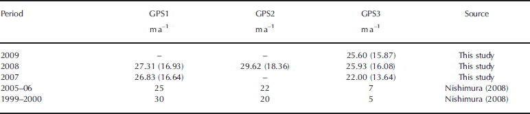
The velocity field at the terminal part of Rhonegletscher is significantly faster than terminal flows observed in similar glaciers without proglacial lakes. This difference is probably due to the influence of lake water. The water level of lake A was ~1.7m below the ice surface in 2008, indicating that 102% of the ice overburden pressure was cancelled by the lake water pressure. The small effective pressure near the terminus creates favourable conditions for basal sliding (e.g. Reference BindschadlerBindschadler, 1983). For example, the ice thickness at GPS3 in 2008 was 20 m and the estimated surface flow speed due to vertical shearing for this thickness is only several millimetres per year (Reference PatersonPaterson, 1994). Thus, nearly 100% of the surface flow observed in this study was caused by basal ice motion. The velocities near lakes A and B are comparable with those in the upper reaches (Fig. 2; Table 1). In this respect, the behaviour of Rhonegletscher is similar to that of Mendenhall Glacier, Alaska, (Reference Motyka, O’Neel, Connor and EchelmeyerMotyka and others, 2002). The flow regime near the terminus was tensile. The longitudinal strain rate between stakes 10 and 15 was 0.064 a-1 in 2008, suggesting substantial glacier thinning due to ice dynamics. We investigate the influence of lake formation on the ice flow speed by comparing our observations at GPS1, GPS2 and GPS3 from 2007 to 2009 with previous studies from 1999–2000 and 2005–06 (Reference NishimuraNishimura, 2008). Note that our measurements are of summer velocities only, while the reported data represent annual velocities. Nevertheless, a significant acceleration of the terminus after lake formation is evident (Table 2). The flow velocity at GPS3 more than tripled from 2006 to 2007. This change cannot be attributed to seasonal variations, because the upper reaches of the glacier at GPS1 accelerated slightly during the same period. The velocity at GPS3 increased by 18% from 2007 to 2008 and became steady in 2009. At GPS2, ~350m from the terminus, the velocity increased by 35% from 2006 to 2008. The accelerations at GPS2 and GPS3 both occurred over a period of 1–2 years after the first recognition of lake B in 2005. It is apparent that the formation and development of the lake triggered the changes in the flow regime near the terminus.
Annual flow velocities for the periods 1999–2000 and 2005–06 and summer flow velocities for 2007–09 at the measurement sites GPS1–3 shown in Figure 3; the presumed annual flow velocities after 2007 are shown in parentheses
The huge surface uplift observed at stakes 9, 15 and 16 was most likely due to flotation of the glacier in the lake. (The terminus of a calving glacier may float when the subglacial water pressure reaches the ice overburden pressure, as described in the introduction.) To examine whether the conditions for floating are met in Rhonegletscher, we compute the effective pressure distribution, P e:
where ρ i = 910 kg m-3 and ρ w = 1000 kg m-3 are ice and water densities, respectively, and g = 9.81ms-2 is the gravitational acceleration. The lake level, z w = 2211.4m, is assumed to be constant and the ice surface (z s) and bed elevations (z b) are given by the digital elevation models (DEMs) constructed in this study (Fig. 3). In 2008, the effective pressure reached zero at the shore of lake A and an area including stake 15 (Fig. 5a). This region extended to the southeast in 2009 as a result of glacier thinning (Fig. 5b). Accordingly, a crevassed zone began to form along the northern margin of lake A towards stake 16 (dotted line in Fig. 5b) in late July 2009; see Figure 6a for a photograph of this zone. The northwestern side of the crevassed zone had gradually risen above the southeastern side (by ~4m in surface elevation) by the beginning of September (Fig. 6b and c). Stakes 9, 15 and 16 were located on the ice that moved upwards. GPS3 was on the other side, but only a few metres from the crevassed zone. The upwards motion at GPS3 can be explained by mechanical coupling to the floating part of the ice: the so-called cantilever effect (Reference NyeNye, 1976). These observations suggest that if the glacier continues to thin, this entire section of the terminus may float and disintegrate over the next few years.
The effective pressure in MPa in (a) 2008 and (b) 2009. The contour intervals are 0.05 MPa. The ice overburden pressure was calculated from the surface and bed DEMs constructed in this study. The dashed line in (b) indicates the crevassed zone described in the text and depicted in Figure 6.

(a, b) Photographs of the terminus of Rhonegletscher on (a) 29 July 2009 and (b) 3 September 2009. The approximate locations of survey stakes are indicated. (c) Photograph of the crevassed zone near stake 9, viewed from the southwest.

The thinning rate at elevations of 2250–2350m during the period 1991–2000 was 1.87ma-1, based on a comparison of DEMs constructed from aerial photographs (Reference ZahnoZahno, 2004). Reference Sugiyama, Tsutaki, Nishimura, Blatter, Bauder and FunkSugiyama and others (2008a) reported that the rate had increased to a value of 2.75 ma-1 from 2000 to 2007. The value of 3.44 ma-1 obtained in this study for the same elevation range shows that the glacier is thinning at a progressively increasing rate in the 21st century. At a constant thinning rate of 3.4ma-1, the lake will continue to expand up-glacier and will reach the location of GPS1 in 2034, 6 years earlier than the prediction of Reference Sugiyama, Tsutaki, Nishimura, Blatter, Bauder and FunkSugiyama and others (2008a). The increase in the thinning rate is consistent with observed mass-balance changes in Swiss glaciers. Reference Huss, Bauder, Funk and HockHuss and others (2008) computed the seasonal mass balance of four glaciers, including Rhonegletscher, for the period 1865– 2006. According to their results, the rate of mass loss progressively increased after a short period of mass gain from 1974 to 1981. The period 1998–2006 was characterized by strongly negative mass balance in all four glaciers. The bed elevation map shown in Figure 3 is important for predicting future expansion of the proglacial lake. We predict that the lake will expand nearly 1 km from the current terminus to the area bounded by the dotted line as the glacier retreats. The maximum depth of the lake upon reaching this size will be ~60 m. A sudden outburst of the lake water is not likely as it is dammed by the bedrock bump, but the glacier dynamics will be influenced by the lake water as long as the glacier is in contact with the lake.
Conclusion
We studied the impact of proglacial lake formation on ice dynamics and glacier evolution at Rhonegletscher. The flow speed and vertical motion of the terminal part of the glacier were measured at high spatial resolution during the 2007– 09 summer seasons. The surface flow velocity near the terminus was fairly large, and its magnitude was similar to the velocity in the upper reaches. Horizontal velocities greater than 20 ma-1 were observed in the region where the ice thickness was only ~20 m. Thus, most of the flow at the terminus was due to basal ice motion. The area was exposed to a very large tensile longitudinal strain, which indicates that a substantial portion of the thinning was due to ice dynamics. Comparisons of our data to studies performed in 1999–2000 and 2005–06 reveal that the flow velocity approximately tripled from 2006 to 2007. It is most likely that the formation and development of the lake triggered this increase in the flow speed. Analysis of the effective pressure confirms that water pressure exceeded the ice overburden pressure in 2008 along the shore of lake A. The region of excess water pressure extended even further under the glacier in 2009 as a result of ice thinning. In the vicinity of the lake, the ice surface moved upwards at a rate greater than 20ma-1 in 2009. This motion is related to the formation of a crevassed zone in the marginal ice, which moved upwards by ~4m over the summer of 2009. It is likely that the entire glacier terminus will float and disintegrate over the next few years if the ice continues to thin. In the elevation range 2250–2350 m, the glacier is thinning at a progressively increasing rate. Assuming that the thinning rate of 3.4 ma-1 observed in 2008–09 is sustained, the glacier will retreat approximately 600m and the lake will expand to its maximum size by 2034.
Acknowledgements
We thank M. Funk, H. Blatter, A. Bauder, T. Wyder, A. Keller, G. Turi and F. Lehner for their help in the field. Materials for the field campaign were loaned by the Section of Glaciology, Swiss Federal Institue of Tchnology (VAW), ETH Zürich. We thank an anonymous referee for providing careful reviews and the scientific editor, D. MacAyeal, for handling the paper. This research was funded by the Japanese Ministry of Education, Science, Sports and Culture through a Grant-in-Aid for Young Scientists (Start-up), 18840002, 2006–07 and by a Grant-in-Aid for Scientific Research C (Capital), 20540418, 2008–10. Additional funding was provided by an internal programme of the Institute of Low Temperature Science, Hokkaido University, by the Inoue Scientific Field Study Foundation and by the Global Centre of Excellence Program (Establishment of Centre for Integrated Field Environmental Science), MEXT, Japan.


