

Introduction
Despite the importance of the ancient settlements of Euesperides and Berenice (modern Benghazi), archaeological research in the region south of Benghazi has been limited, leaving large areas insufficiently documented and poorly understood. The absence of systematic surveys and excavations has resulted in a fragmented understanding of settlement patterns, economic activities and cultural developments in this part of Cyrenaica, especially when contrasted with the comparatively well-studied areas around Cyrene on the upper plateau. Addressing this gap is essential for informed decision-making, sustainable heritage management and the advancement of regional scientific knowledge.
Furthermore, in recent decades, the fragility of the heritage not only in this region but in many parts of Libya has become increasingly evident. Libya’s archaeological heritage is under grave threat due to a combination of factors, including conflict, urbanization, agricultural development, looting, climate change and many other issues (see e.g. Al Raeid et al. Reference Al Raeid, Di Valerio, Di Antonio, Menozzi, El Mziene and Tamburrino2016; ASOR 2020; Brooks et al. Reference Brooks, Clarke, Wambui Ngaruiya and Wangui2020; Emrage and Nikolaus Reference Emrage and Nikolaus2023; Menozzi et al. Reference Menozzi, Di Valerio, Tamburrino, Shariff, d’Ercole and Di Antonio2017; Rayne et al. Reference Rayne, Sheldrick and Nikolaus2017a; Saad et al. Reference Saad, Hati, Antonelli, Menozzi, Petraccia and Somma2016; Westley et al. Reference Westley, Andreou, El Safadi, Huigens, Nikolaus, Ortiz-Vazquez, Ray, Smith, Tews, Blue and Breen2021). Many of these issues have only intensified since the political instability which has affected the country since 2011, and in 2016 Libya’s five UNESCO World Heritage sites were added to the World Heritage in Danger list, reflecting the dire situation for this invaluable cultural heritage (UNESCO 2025); as of publication, four sites remain, Ghadames having been removed from the list in July 2025. The unprecedented devastation caused by Storm Daniel in 2023 in Cyrenaica has also highlighted the increasing threat posed by climate change (Al-Augab and Abdulkariem Reference Al-Augab and Abdulkariem2023; Walda et al. Reference Walda, Alkhalaf and Wootton2023a; 2023b).
Since 2015, the Endangered Archaeology in the Middle East and North Africa (EAMENA) project has worked to document and analyse threats like these to heritage sites not only in Libya but across the MENA region, primarily emphasizing the use and development of remote sensing methodologies and open-access data (Bewley et al. Reference Bewley, Wilson, Kennedy, Mattingly, Banks, Bishop, Bradbury, Cunliffe, Fradley, Jennings, Mason, Rayne, Sterry, Sheldrick, Zerbini, Campana, Scopigno, Carpentiero and Cirillo2016; Rayne et al. Reference Rayne, Sheldrick and Nikolaus2017a; Rayne et al. Reference Rayne, Bradbury, Mattingly, Philip, Bewley and Wilson2017b; Hobson Reference Hobson2019). As part of this work, the EAMENA project team has developed a novel heritage monitoring tool, the EAMENA Machine Learning Automated Change Detection (MLACD) tool, which utilizes the Google Earth Engine platform to automatically identify landscape change and potential threats to heritage sites over time (Mahmoud et al. Reference Mahmoud, Sheldrick and Ahmed2024). In 2023, the EAMENA project was awarded funding from the British Council’s Cultural Protection Fund (CPF) to train Libyan archaeologists in this method and to fund related fieldwork. Between late 2023 and 2024, more than 20 Libyan heritage professionals from the Department of Antiquities (DoA) participated in comprehensive training workshops that introduced them to the use of this tool to detect and monitor disturbances and threats to heritage (Sheldrick et al. Reference Sheldrick, Buzaian and Mahmoud2025).
This article presents the first in a series of four case studies which were undertaken as part of the EAMENA-CPF training programme and collaboration and which apply the MLACD method. It investigates the Lefakat region, south of Benghazi in the western part of Cyrenaica, which is facing rapid urbanization, placing heritage sites under immediate threat. An initial desk-based assessment was conducted to identify archaeological sites and apply the MLACD method. Following the remote sensing analyses, a team of Libyan archaeologists from the DoA conducted fieldwork to verify and validate the results. The remote sensing and fieldwork survey documented 30 archaeological sites, primarily dating from the Roman period, recording new information about them and assessing their condition. The threats affecting them relate primarily to urbanization and vegetation growth, looting and rubbish dumping. The approach highlighted in this article combines advanced remote sensing technologies with fieldwork validation, providing a robust framework for monitoring and safeguarding archaeological sites.
Study area and background
The region of western Cyrenaica is generally characterized by its roughly flat terrain, defined by the scarps of the Gebel Akhdar to the south and the coast to the north and west, extending from Tolmeita (ancient Ptolemais) in the north and gradually merging into the Syrtic Desert to the south. A considerable part of this region consists of rocky limestone outcrops, making it unsuitable for cultivation. However, scattered pockets, especially in the Al Qawarishah area, have a thick soil cover, allowing for small-scale irrigation using shallow-dug wells. Elsewhere, dry farming is practised intermittently, depending on soil depth and rainfall. Barley is the main crop in the region, while wheat is cultivated on a smaller scale. Rainfall is seasonal, chiefly falling during the winter months, varying significantly in both quantity and intensity from year to year with an average annual rainfall of 273 mm (Doyel and Maguire Reference Doyel and Maguire1964, 6). Periodic droughts recur every four to five years. The dry climate is exacerbated by the ghibli, a hot, arid wind that blows from the south and is invariably accompanied by sand and dust.
The Lefakat case study region is situated within the Benghazi coastal plain, approximately 15 km south of Benghazi city, covering an area of ca. 219 sq km (Figure 1). While the study area is predominantly part of the Lefakat district, it also includes portions of neighbouring areas such as Ganfouda, Teeka, Al-Guarsha, Umm-Mabruka, Al-Nawaqia, Sidi Faraj and Al-Muqazha. Near the eastern limit of the case study area, the plain is crossed by the Wadi al-Qattarah, which originates in the gebel and drains into the sea. Before the construction of the Wadi al-Qattarah dam, intense and prolonged rainfall often caused the wadi to overflow, devastating the city of Benghazi and flooding large areas to the south. The area lacks perennial surface water sources, and the groundwater reservoir’s upper surface is generally mineralized, with increasing salinity beyond 10 m below the water table. In 1964, the water table was near sea level along the shore but gradually rose to elevations of 5 m or more near the escarpment at the inland edge of the coastal plain (Doyel and Maguire Reference Doyel and Maguire1964, 10–11). Over the past 20 years, the depth of groundwater has fallen by more than 60 m, and heavy withdrawals for irrigation and domestic needs have ultimately resulted in saltwater contamination.
Lefakat case study area, with locations of neighbouring ancient sites and other sites mentioned in the text. Basemap: Esri World Imagery (Sources: Esri, Earthstar Geographics).

Historical background and previous work
The study area is located in the southern environs of Benghazi and was part of the ancient territory of Euesperides and its successor, Berenice. The city now known as Benghazi, Libya’s second-largest urban centre, traces its origins to the settlement of Euesperides, founded in the early sixth century BC (Wilson Reference Wilson2016). As the westernmost of the Cyrenaican cities, Euesperides marked the farthest point reached by the Persian expedition into Cyrenaica in 515 BC, as recorded by Herodotus (4.204). Herodotus (4.172) also describes Nasamonian herds and flocks along the coast south of Euesperides and highlights the region’s exceptional fertility, noting that in optimal years, the land yielded crops a hundredfold (4.198), and other sources note that the surrounding plain was renowned for its high-quality artichokes and the abundance of local fish species (Buzaian and Lloyd Reference Buzaian and Lloyd1996, 132). Even today, the area remains ideal for grazing and is primarily used for pasturing livestock.
However, Euesperides proved short lived compared with other Cyrenaican cities. By the mid-third century BC, it was abruptly abandoned (Laronde Reference Laronde1987, 390, 392–96; Wilson et al. Reference Wilson, Bennett, Buzaian, Buttrey, Göransson, Hall, Kattenberg, Scott, Swift and Zimi2002, 121) in favour of a new coastal settlement, Berenice. Strabo (17.3.20) mentioned Berenice as a harbour, recording its name in place of Euesperides. Under Roman rule after 96 BC, it flourished as part of the province of Crete and Cyrenaica, serving as a vital port and urban hub, though it never surpassed the regional importance of Cyrene or Apollonia.
Information about early occupation in the area south of Berenice is limited. This is mainly due to a traditional lack of interest in rural archaeology in Cyrenaica, with a clear bias toward urban centres (though notable exceptions include Emrage Reference Emrage2015; Buzaian Reference Buzaian2022). However, based on two recently discovered tombs, it can be suggested that early settlement along the coastal plain south of Berenice dates back at least to the Hellenistic period. The first is an underground tomb uncovered in the Taballino district, approximately 7 km north of the case study area. This tomb features loculi opening off a forecourt cut into the bedrock and is accessed via a descending dromos. The associated burial goods mainly date to the Hellenistic period (Buzaian Reference Buzaian2013 14–17). The second tomb was discovered during land leveling for new housing, within the boundaries of the case study area just west of Qasr Ebeid. Similar in design to the first, it consists of a single underground level with multiple loculi opening into a central chamber. Artefacts recovered from this tomb date from the early first century BC to the beginning of the first century AD (Buzaian Reference Buzaian2022, Appendices, 142).
Investigations by R.G. Goodchild during his expeditionary survey Map of Roman Libya in 1950–51 (Goodchild Reference Goodchild1952) laid the groundwork for understanding Cyrenaica’s rural landscape more widely, particularly its unique defensive structures known as qsur (singular qasr). In the region between Benghazi and Agedabiya, approximately 150 km to the south, Goodchild identified a series of fortified farms that he classified as ‘Romano-Libyan’. These were primarily concentrated around Ghemines (ca. 50 km south of Benghazi) and included sites such as Qasr el-Ataresh, Qasr Bu-Misceili, Qasr El-Chel, two forts at El-Frascit and Qasr Haddumah near al-Magrun. Further east and north, he discovered additional fortified structures, including Zawiet et-Tailmun, a fort at Sceleidima, an outpost at Zawiet Msus and Qsur Khalita.
Some of the fortified buildings recorded by Goodchild were constructed of well-built, dressed and coursed masonry with angled corners, but others, particularly around Ghemines, had outer walls constructed from randomly coursed, rough, untrimmed large stones with rounded corners. This led Goodchild to propose that the former structures, such as Qasr el-Heneia south of Agedabiya, were Roman military structures, whereas the latter, while also Roman or Byzantine in date and influenced by the architecture of the Roman structures, also incorporated more local architectural construction techniques and traditions (Goodchild Reference Goodchild1951, 143).
In 1950, David Smith conducted a small, unpublished reconnaissance survey of sites between Ghemines and Benghazi, producing a series of annotated sketches now preserved in the BILNAS Archive currently housed at the University of Leicester (BILNAS/D27). Further work by Goodchild in the 1950s, in collaboration with J.B. Ward-Perkins (Reference Ward-Perkins, Goodchild and Reynolds2003), primarily focused on Christian monuments, but also provided valuable insight into rural settlement patterns. Only one of the sites mentioned in this study, Qsur Khalita, falls within the current case study area (Goodchild and Ward-Perkins Reference Ward-Perkins, Goodchild and Reynolds2003, 430). This site was later revisited and documented by Ahmed Buzaian during his research on olive-oil production in Cyrenaica (Buzaian Reference Buzaian2022, 194–96; also described in Kenrick Reference Kenrick2013, 33–34); three additional sites within the case study area (Qasr Ebeid, Siret al-Thaalib and and Siret Sidi Ali Zehri) were also documented during the Buzaian’s survey (Buzaian Reference Buzaian2022, Appendices, 142–43, 197 and 255–56, respectively). Additionally, one more site within the case study area has been identified by the Department of Antiquities in Benghazi during their regular monitoring programme.
The southwestern region of Cyrenaica faced mounting pressures in late antiquity but endured into the Byzantine era. Small-scale excavations in 1962 at Qasr al-Arid (ca. 6 km south of the case study area) by the Pennsylvania expedition recovered evidence of occupation from the third to the fifth centuries AD (Carter Reference Carter1963, 19–20). A network of military outposts played a critical role in defending Graeco-Roman cities from incursions by local tribes of the Syrtic region (Goodchild Reference Goodchild1951, 143–44).
The Islamic conquest in the mid seventh century AD marked a significant transformation in the region’s political and cultural landscape. While archaeological data from the early Islamic period remains limited, some indications of continued occupation and activity in the area south of Benghazi can be traced through scattered surface finds and reused architectural materials. More tangible evidence emerges from the Ottoman period, during which the region saw a modest revival, primarily in the form of agricultural and pastoral use. This continuity is further supported by traces of rural settlements and infrastructural development dating to the period of Italian occupation in the early twentieth century. Together, these findings suggest that while the region’s prominence fluctuated over time, it retained a degree of strategic and economic importance well beyond antiquity.
Prior to our case study, a total of 13 sites had already been recorded in the EAMENA database in the Lefakat case study area, and a further 25 sites were then identified in a targeted remote sensing satellite imagery survey of the area and one more site, Bu-Emleleikh, was recorded by the DoA. As further explained in the Fieldwork Survey section below, for various reasons only 30 of the 39 sites originally recorded were validated in the field. For this reason, the analysis and results presented in the following sections are for only the 30 sites which were verified and visited in the field in order to facilitate the comparison between the methods.
Modern threats
The heritage of the Lefakat region is under direct threat from a number of issues, the most pressing of which is the rising population and urbanization of Benghazi, which is rapidly expanding to the south. Historical census data indicates that Benghazi’s population expanded from 70,533 in 1954 (Doyel and Maguire Reference Doyel and Maguire1964) to approximately 500,120 in 1995 and 670,797 in 2006 (Alzayani et al. Reference Alzayani, Abuzreda, Saeid, Mohammed and Elbarjo2025, 47). Political instability and the lack of recent censuses have made it difficult to determine precise population figures, but the current metro area population of Benghazi in 2025 is estimated at 882,000 (https://www.macrotrends.net/global-metrics/cities/21780/banghazi/population).
The ancient city of Euesperides, located in the north part of modern Benghazi has been subject to extensive destruction due to uncontrolled urban growth (Lloyd et al. Reference Lloyd, Buzaian and Coulton1995; Buzaian and Lloyd Reference Buzaian and Lloyd1996; Gill and Flecks Reference Gill, Flecks and Westgate2007). Urban development within the city and its surroundings has led to the destruction of many archaeological sites, including Qasr Shibna (Bennett and Buzaian Reference Bennett and Buzaian2006) and Siret Ard Egreish (Buzaian Reference Buzaian2022, Appendices, 152). A significant portion of a large Roman-era settlement identified within the campus of Benghazi University was partially bulldozed during recent campus expansion to make way for a road and landscaping, including tree planting (Bennett and Buzaian Reference Bennett and Buzaian2006, 41). The area to the southwest of Benghazi, extending to Ghemines, faces increasing pressure from urban expansion, exacerbated by a clear lack of planning control and archaeological risk assessment. A plan known as the ‘Chinese Housing Buildings’ project was established in Benghazi in 2008, with the aim of constructing 20,000 residential units in the Ganfouda and Jardinah areas (https://lana.gov.ly/post.php?lang=ar&id=21873). As part of this development, the settlements of Housh Ben-Zableh and Bu-Emleleikh were completely destroyed, and further archaeological sites are expected to be bulldozed.
In addition to the urban expansion, a number of other threats have also been identified in the region. Numerous tarmac and unsurfaced roads intersect the case study region, which has led to the destruction of several archaeological sites. Another threat associated with urban expansion is quarrying for construction materials, as seen in the ancient site of Tansoluk, 40 km northeast of Benghazi. This activity is widespread across the case study area, impacting ancient archaeological sites and causing irreparable damage. Additionally, modern agricultural activity has impacted many archaeological sites, particularly around the modern village of Jardinah, 35 km south of Benghazi, where new farms using central pivot irrigation systems have been established. Further east along the coast, the ancient city of Hadrianopolis has suffered extensive damage from agricultural practices, with the ancient aqueduct system particularly impacted by land reclamation (Jones and Little Reference Jones and Little1971). Finally, other threats, such as looting and vandalism, have become widespread in the region. This includes illegal excavation, as seen at Siret al-Mshegah (Buzaian Reference Buzaian2022, Appendices: 181–82), as well as rubbish dumping, graffiti and small fires (Nikolaus et al. Reference Nikolaus, Abdrbba and Emrage2022).
Machine learning automated change detection analysis
The EAMENA MLACD tool is an adaptable method which uses open-access satellite imagery data and cloud-computing power available via Google Earth Engine (GEE) to automatically identify landscape change and threats to heritage sites (see Mahmoud et al. Reference Mahmoud, Sheldrick and Ahmed2024, for the full publication and technical breakdown of the method; see also Sheldrick et al. Reference Sheldrick, Buzaian and Mahmoud2025 for an overview. The code and training documentation are available online and open-access via Github, see Mahmoud Reference Mahmoud2023; Reference Mahmoud2025).
The first step in the analysis was to configure the tool for the Lefakat case study by inputting essential parameters including the study area boundary, the locations of the 30 sites under investigation (EAMENA database 2025) and the time period selected for analysis, which was February 2019 to January 2024.
The MLACD tool works by identifying all of the Sentinel-2 satellite images (10 m resolution) available in GEE’s database between the selected dates and classifying each image into different land-use classes. The tool identified 105 satellite images dating to within this period for the Lefakat area and, using a supervised classification algorithm (Random Forest), the tool was trained to identify three land-use classes: Bare (B), Urban (U) and Vegetation (V). The training dataset used was collected from Planetscope satellite imagery (3 m resolution).
The MLACD detects both continuous and cumulative changes in land cover by conducting two different types of analysis. The first analysis looks at the full series of satellite images for the period between the selected start and end dates, and shows how the landscape has changed over time. In addition, the time series analysis can provide an understanding of when specific disturbances or threats first occurred and whether they are still ongoing.
The second analysis is generated from the comparison of two individual satellite images, chosen by the user, to identify the specific changes in land-cover class that have occured between those two dates. This creates a new set of change classes, which identify, for example where areas classified in the first image as ‘Bare’ have changed in the later image to ‘Vegetation’, signalling potential agricultural expansion or other encroachment of vegetation, or a change from ‘Bare’ to ‘Urban’, potentially indicating construction activity (Table 1).
Classification change table for the changes in pixels between two selected satellite images of different dates in the Lefakat study area

Many of the archaeological sites identified in this region have a similar spectral reflectance to bare soil, as they are often constructed of local stone or mudbrick, and so the sites themselves are therefore often classified by the MLACD as Bare. This means that in this case study the MLACD is primarily useful in identifying two types of change: from Bare to Urban (Change Class 2, i.e. construction/urban expansion) and from Bare to Vegetation (Change Class 3, i.e. agricultural expansion or other vegetation encroachment). To ensure the detection of all changes within the vicinity of each site, the analysis identifies any changes within a buffer zone of 100 m.
Figure 2 shows the results of the MLACD comparing two Sentinel-2 images from the beginning and end of the period of study: 3 February 2019 and 18 January 2024 (Figure 2, a–b), and their respective land-use classification images (Figure 2, c–d). The binary change map (Figure 2e) highlights all of the pixels where any change between classes has been identified in red, and any pixels with no change in black. Finally, the classification change map (Figure 2f) classifies the types of changes, as outlined in Table 1 above, for each pixel in the study area.
Results of the MLACD analysis for the Lefakat case study area for the period between 3 February 2019 and 18 January 2024. (a) Sentinel-2 image for 3 February 2019; (b) Sentinel-2 image for 18 January 2024; (c) land cover classification map for 3 February 2019; (d) land cover classification map for 18 January 2024; (e) binary change map; (f) classification change map.

The MLACD analysis comparing the satellite images from 3 February 2019 and 18 January 2024 detected pixels which had changed from the Bare to Urban land-use classes within the 100 m buffer zones of all 30 heritage sites in the Lefakat case study area (Figure 3a). Pixels which had changed from the Bare to Vegetation classes between these dates were detected within the buffer zones of 20 sites (Figure 3b).
Classification change maps highlighting the change from Bare to Urban class (a); and Bare to Vegetation class (b), between 3 February 2019 and 18 January 2024, and the distribution of impacted sites.

The MLACD tool also allows the user to produce a time series analysis at specific locations within the buffer zone of heritage sites in order to identify precise dates of land-cover changes during the study period. An example of how this works can be illustrated for the heritage site of Umm-Mabruka, a ditched fortified site (qasr), located along the road connecting the Al-Guarsha and Bu-Idreesah areas. The MLACD analysis detected changes in land-cover class from Bare to Urban within the 100 m buffer zone (Figure 4a), which was confirmed in the time series results at a defined location P (Figure 4b). The time series analysis indicates that the change in land cover first appeared in an image dated 24 May 2019, with some variation between the Bare and Urban classes from late May to the end of September 2019, probably signifiying the period of construction.
Construction activity at Umm-Mabruka detected using the MLACD. (a) areas of detected change from the Bare to Urban classes; (b) classification time series at location P; (c) normalized difference vegetation index (NDVI) time series at location P; (d) Umm-Mabruka before the start of the construction activity in March 2019; (e) during the construction activity in September 2019; (f) Umm-Mabruka in March 2023, showing further construction; (g) photo of a newly constructed building to the west of the qasr. Basemaps: (a) Google Satellite Imagery (accessed in QGIS via XYZ Tiles, September 2025) (d)-(f) Maxar Technologies, Google Earth.

Validation using high-resolution imagery in Google Earth confirms these land-cover changes, showing the construction of a new building approximately 40 m west of the qasr: Figure 4d shows the site in March 2019 before the start of the construction activity while Figure 4e shows the building under construction during the month of September 2019; later imagery shows that it was fully completed by the end of that year. The appearance of this new building is also reflected in the Normalized Difference Vegetation Index (NDVI) time series (Figure 4c), which indicates a shift from low NDVI values, suggesting sparse vegetation or arid conditions, to nearly zero NDVI values after 24 May 2019, indicating the presence of the newly-constructed building. Additional buildings which appear in an image from March 2023 were also picked up by the MLACD on the east side of the buffer zone (Figure 4f). These results were subsequently validated on the ground during the fieldwork which took place in January 2024 (see below) (Figure 4g).
Fieldwork survey
The fieldwork survey of the Lefakat region took place over 17 days in February 2024, and was conducted by a team of four heritage professionals from the Libyan DoA, led by Naser Alhrari. The first aim of the survey was to carry out a systematic archaeological and condition assessment of each site. The second was to validate the EAMENA MLACD results in order to evaluate the detection capabilities and reliability of the remote sensing method. In addition, the fieldwork was important for collecting ground-truth training samples to improve the accuracy of classifications generated by the MLACD.
As mentioned above, a total of 39 sites were initially recorded by the EAMENA team within the case study area from a combination of previously published surveys and remote sensing. Three of the sites which had been identified through remote sensing were determined by the survey team not to be heritage sites, and another three could not be located during the survey, highlighting the limitations of remote sensing and the importance of field validation. A further three sites could not be visited, as they were located on private property where access was denied and it was therefore not possible to determine whether they were indeed heritage sites and, if so, whether they still existed. Therefore, the number of heritage sites for which there was validation and comparison with the MLACD results was 30.
Methodology
The field survey team employed a specialized recording sheet to document the archaeological sites and the natural and anthropogenic changes observed during the field survey at each site visited (Figure 5). The forms included space for field observations, including topography, surface visibility, site interpretation, site condition, disturbances and potential threats, as well as space to record the MLACD results, in order to facilitate comparison and validation.
Site recording form used during fieldwork.

In addition to the recording forms, photographs of each site were captured to document its condition, location and relationship to the surrounding environment. Any disturbances present were recorded with photographs and their location recorded using handheld GPS units. Following the fieldwork, the data collected were compiled into a digital format for deposit into the EAMENA database. Due to the rapid nature of the survey and assessment, no sampling strategy or pottery collection was undertaken at any of the sites visited, though rapid identification of surface material was noted where possible in order to assign approximate dates.
During the fieldwork, several challenges were encountered that impacted the progress and scope of the study. Some of the archaeological sites identified were located on private property, complicating access and requiring additional permissions. Furthermore, the large size of certain sites, such as Al-Qasaibah and Nuqtat Njayeb, made it difficult for the team to explore and document them in their entirety in the time available. In addition, completing the assessment and documentation of sites in the south area of Benghazi, from Bu-Fakhra to Ghemines, especially along the seacoast, posed challenges due to ongoing construction, underscoring the urgency and importance of preserving these vulnerable cultural heritage areas.
Archaeological assessment
The archaeological sites recorded during the field survey were predominantly related to agriculture and animal husbandry. Because no pottery was collected during the survey, no secure dating evidence was obtained for occupational lifespan of the sites. However, rapid observations of surface pottery, including both coarse wares and fine wares, broadly suggest a date range from the early first century BC to the seventh century AD for most of the recorded sites. Evidence from the Islamic period is also present, including glazed pottery from this era which was observed scattered on the surface at the site of Siret Abdul-al-Mawla. Historic structures dating to the Ottoman and Italian colonial periods were also recorded. The catalogue of sites and summary results of the survey are presented below in Table 2, and their distribution in Figure 6.
Location of heritage sites recorded and verified in the Lefakat case study area. Numbers correspond to those listed in Table 2. Basemap: Esri World Imagery (Sources: Esri, Earthstar Geographics, Maxar Technologies).

Heritage sites recorded during the Lefakat field survey, including locations (projected to WGS84 coordinate system)

As noted above, only a small number of the sites investigated in this case study had been recorded previously and, with only a few notable exceptions, research into ancient rural settlements in Cyrenaica has until recently been limited (see Abdussaid et al. Reference Abdussaid, Abdalnaby, Gweidr, Farag, Hsoona and Al-Mzeini1984; Emrage Reference Emrage2015; Buzaian Reference Buzaian2022). Of the 30 sites investigated in the Lefakat case study area, 25 have been assigned broadly to the Roman or late antique period. This case study has therefore provided the opportunity to conduct a systematic assessment of these ancient sites in the Lefakat region and for the first time to situate them within the larger context of rural landscapes in Cyrenaica.
An archaeological survey conducted in the hinterland of the Wadi al-Kuf region (ca. 150 km northeast of Benghazi) provided valuable insights into farming site types, with basic discussions on chronology and functions of the investigated locations (Abdussaid et al. Reference Abdussaid, Abdalnaby, Gweidr, Farag, Hsoona and Al-Mzeini1984). Subsequent research by A. Emrage in the 2010s in the same area primarily focused on fortified sites, which were broadly categorized into two main types: civilian and military. Civilian structures were divided into fortified qsur and unfortified qasr-like buildings, both commonly associated with farming and manufacturing activities. Military structures, characterized by their strategic locations and absence of agricultural or industrial features, were further classified by size into four sub-types: forts, fortlets (with or without towers), outposts and watchtowers (Emrage Reference Emrage2015, 133–52).
Another recent survey documented rural settlements in the territory of Cyrene (modern Shahat), focusing on late antique sites located between Messa and al-Gubbah and addressing the growing threats to their preservation (Fossataro Reference Fossataro and Hakan2009; Menozzi Reference Menozzi and Ensoli2012; Menozzi and Fossataro Reference Menozzi and Fossataro2010; Menozzi et al. Reference Menozzi, Di Valerio, Tamburrino, Shariff, d’Ercole and Di Antonio2017; Saad et al. Reference Saad, Hati, Antonelli, Menozzi, Petraccia and Somma2016). The settlements recorded in this study were classified into three types: pseudo-urban settlements with organized layouts and public spaces; secondary villages with rural characteristics and some public buildings; and scattered rural sites, including farms, qsur and isolated churches (Saad et al. Reference Saad, Hati, Antonelli, Menozzi, Petraccia and Somma2016).
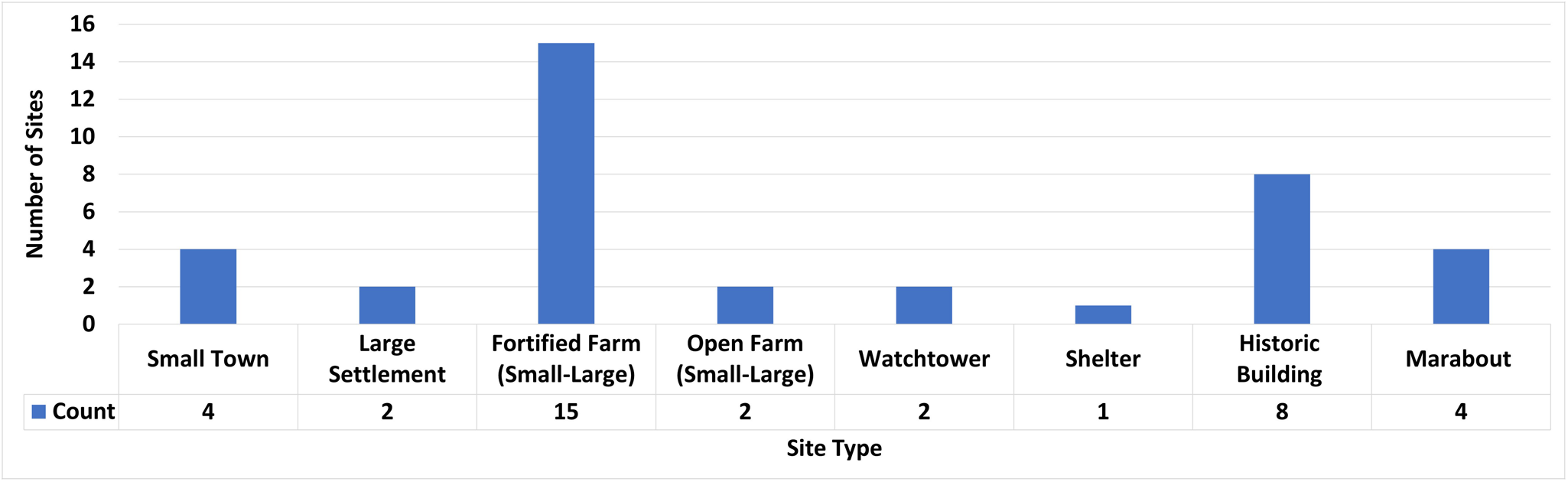
These surveys both focused on relatively limited geographic areas, and are therefore not regionally representative. A further study by Buzaian of rural sites across Cyrenaica, focusing on olive presses and oil production (Buzaian Reference Buzaian2022), adapted the settlement typologies presented in the models put forward by Emrage (Reference Emrage2015) and Saad et al. (Reference Saad, Hati, Antonelli, Menozzi, Petraccia and Somma2016), to be applied more broadly to represent regional patterns. Five principal types of ancient sites and settlements based on the classification proposed by Buzaian (Reference Buzaian2022, 79–99) have been identified in the Lefakat case study area. A further three types of sites of later date (shelters, historic buildings and marabouts) were also identified, some of which were on the same sites as ancient ones (Table 2; Figure 7).
Types of heritage sites recorded in the Lefakat region.

Small towns
The first type is the small town, referring to settlements covering over 20 ha, with the largest, Siret Abdul-al-Mawla, extending to approximately 45 ha. These settlements were typically focused around a large central qasr and featured urban characteristics, such as an organized layout with regularly distributed residential buildings and subterranean rock-cut tombs at the borders of the inhabited area. Four small towns were recorded, and surface pottery suggests that they primarily dated to the late Roman period. These towns were typically located near fertile land; the small town of Siret Sidi Ali Zehri, for example, had at least eight olive- crushing basins recorded, suggesting large-scale olive-oil production and emphasizing the agricultural potential of the surrounding area (Buzaian Reference Buzaian2022, 83, Table 6.2). One small town, Al-Qasaibah, showed evidence of possible ecclesiastical features, usually associated with churches. On Cyrenaica’s upper plateau lands, archaeological findings indicate that churches often played a central role in town planning during the late Roman period (Saad et al. Reference Saad, Hati, Antonelli, Menozzi, Petraccia and Somma2016, 44).
Large settlements
The second main type of sites recorded were large settlements, defined as settlements which occupy an area of 5 ha or more, but less than 20 ha. These generally consisted of clusters of buildings arranged around a central fortified structure (qasr), which was encircled by a ditch. Overall, the buildings in these settlements were simple and uniform, associated with agricultural and industrial features; evidence from other parts of Cyrenaica suggests that these types of settlements may have developed from earlier open farms (Buzaian Reference Buzaian2022, 92). Two large settlements of this type were identified in the Lefakat case study area. The first is Karmet Dakhil-Allah, which spans a substantial area of around 15 hectares. Near its centre stands a qasr, situated on a mound and surrounded by a moat, with portions of its walls still intact (Figure 8a). On the southern side of the qasr, buildings with clearly visible internal layouts can be observed. Further to the southeast, about 180 m away, lies a cluster of underground, rock-cut tombs accessed via a rock staircase. The second large settlement recorded was Hosh Ben-Zableh (Figure 8b). This site has unfortunately been completely demolished to make way for a new housing project (Figure 8c); however, records from the DoA Archive at Benghazi indicate that the site probably once extended over an area of approximately 5 ha.
Examples of large settlements recorded in the Lefakat area. (a) Qasr Karmet Dakhil-Allah; (b) an archived image showing Hosh Ben-Zebleh before 2009 (DoA Benghazi archive); (c) Hosh Ben-Zebleh as photographed during the fieldwork in January 2024 showing its destruction.

Fortified farms
The third type of site recorded was the fortified farm or qasr, a defensive structure characterized by a thick outer wall, often accompanied by a ditch and revetment. A qasr located in isolation within a naturally defensive setting, lacking signs of agricultural, industrial or associated structures, probably served a military function. In contrast, the presence of features associated with agricultural production (e.g. olive-oil presses) normally indicates a primarily civilian use, though a defensive role cannot be entirely dismissed; thus, the term ‘fortified farm’ is considered appropriate. All 15 of the qasr sites recorded in the Lefakat region fall into this latter category.
Fortified farms were further divided into large or small, based on their size: a large fortified farm was defined as covering an area of 2 to 4 ha, while small fortified farms covered between 0.5 and 1.5 hectares. Six large fortified farms were identified at Umm-Lheimia, Mafreg al-Zeitoona (Figure 9), Siret Umm-ar-Rakham, Housh Shatwan 2, Bu-Emleleikh and Umm-Mabruka. Nine small fortified farms were also identified, displaying architectural features similar to those of the larger fortified farms, simply on a smaller scale. All of these structures primarily utilized large, roughly trimmed stones, with occasional use of ashlar blocks.
Field survey photo documenting a fortified farm at Mafreg al-Zeitoona.

Open farms
The fourth main type of site recorded was open farms, which consist of clusters of structures arranged in a seemingly random manner, with no fortified building present. Like fortified farms, these have been divided into large open farms, covering areas from 2 to 6 ha, and small open farms, occupying an area between 0.1 and 2 ha. Two open farms were recorded in the Lefakat area, one large and one small. The latter, Alseirah al-Hamrah, yielded evidence of pressing facilities.
Watchtowers
The fifth type of site recorded was structures interpreted as watchtowers. These sites are characterized by their small size, less than 100 sq m, and the absence of industrial and agricultural features, suggesting that they had a military, or at least explicitly defensive, purpose. Two such structures, strategically positioned on slightly elevated terrain, were recorded within the Lefakat case study area: Al-Abeidiyah 1 and Snab Abdul-Aziz.
Other features
Evidence of agricultural production and industrial activity was identified at many of these sites, irrespective of type. Such features include tanks with waterproof lining and pressing elements, recorded at Siret Sidi Ali Zehri, Qsur Khalita, Qasr Ebeid, Alseirah al-Hamrah, Umm-Mabruka and Karmet Dakhil-Allah. Rock-cut tombs are also featured in some of these sites and are accessible via a flight of stairs, with burial chambers opening onto a central courtyard. Notably, these tombs are often situated at a distance from the main settlement. One of these tombs, with the small fortified farms, Qasr Ebeid, has been dated to the early first century BC, the earliest evidence for occupation within the Lefakat case study area.
Most of these settlements endured through the late antique period, coinciding with the spread of Christianity in the region; at Qsur Khalita, for example, marble chancel posts indicate continuity of use into Christian times (Ward-Perkins and Goodchild Reference Ward-Perkins, Goodchild and Reynolds2003, 430). The survey also recorded evidence for at least some activity during the Islamic period. Early Islamic glazed pottery was observed at sites such as Siret Abdul-al-Mawla.
Four sites also had marabouts, shrines dedicated to local holy men, which probably date from the medieval period. These modest, square-shaped structures served as places of pilgrimage, often for individuals suffering from physical ailments or mental distress, or for women seeking fertility. These shrines were usually located near or among the ruins of ancient rural settlements, primarily because such sites provided easy access to building materials (Della Cella Reference Della Cella1819, 31; Munzi et al. Reference Munzi, Felici, Matoug, Sjöström and Zocchi2016, 95). Although three of these had been destroyed more than ten years ago (see below), their presence had previously been recorded using historic satellite imagery (Sterry Reference Sterry2017).
The large settlement of Hosh Ben Zableh had modest structures dating to the Ottoman period (1638–1911), and eight sites date to the period of Italian occupation (1911–1943). Four of these were certainly established on top of earlier sites dating to the Roman period, and it is possible that the other four may have been built upon the foundations of earlier sites, though without further investigation this is not clear. This relatively modern occupation was represented by buildings of various sizes and appears to have been agricultural in character, with one site possibly connected to patrolling activities. Finally, there is one natural shelter which could potentially have been in use since the Roman period and is still in use to the present time.
Condition assessment
The fieldwork survey also undertook condition assessments of each site in the Lefakat case study area and documented any visible disturbances and threats (Table 3). As outlined above, the MLACD analysis had already indicated the presence of disturbances and threats by identifying changes in the land-use classification between February 2019 and January 2024. The main changes detected by the MLACD were areas classified as Bare that had changed to Urban or Vegetation, strongly suggesting construction activites and agricultural expansion, respectively. A primary aim of the fieldwork, therefore, was to validate the identification of these problems on the ground, and document them in more detail. In addition, many types of disturbances and threats, such as looting, graffiti, small-scale dumping, burning and the re-occupation of ancient sites for modern purposes, were not able to be identified by the MLACD or through remote sensing.
Recorded conditions and disturbances at heritage sites in the Lefakat region

The overall condition of each site was evaluated and recorded according to the rankings used in the EAMENA database, from Good to Destroyed, and based on the extent of disturbance observed. Of the 30 visited sites, not one was found to be in a Good condition, and it was evident that all sites were facing serious threats from either natural or human factors. Field evaluation revealed that there were seven in Fair condition (little evidence of active deterioration), 18 in Poor condition (moderate signs of active deterioration), three in Very Bad condition (serious signs of active deterioration) and two were completely Destroyed (Figure 10).
Overall condition of sites recorded in the Lefakat case study area. Basemap: Esri World Imagery (Sources: Esri, Earthstar Geographics, Maxar Technologies).

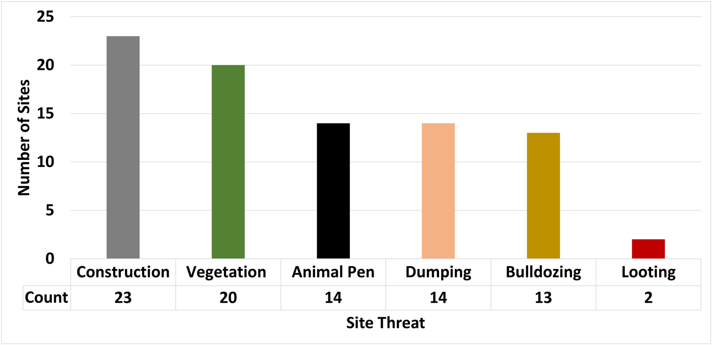
Following an assessment of the overall condition, the specific disturbances and threats observed at each site were also recorded. Overall, most disturbances, apart from decay and neglect, have been caused by human activities, primarily through construction, development and infrastructure projects. Modern agricultural activity had also affected a number of sites. Six main categories of disturbance were recorded during the fieldwork at the sites in the Lefakat case study area: construction, vegetation, animal pens, dumping, bulldozing and looting (Figure 11).
Number of sites in the Lefakat case study area affected by different disturbances.

The largest category of disturbance observed during the fieldwork was construction and building activity, which was recorded at 23 sites, which is unsurprising given the rapid expansion and building development south of Benghazi. Urbanization has exacerbated damage to archaeological heritage in the region of Benghazi due to the absence of comprehensive state plans for urban development and a lack of law enforcement, particularly in the aftermath of the 2011 revolution. This has led to a proliferation of random housing construction, which has significantly impacted the preservation of archaeological sites in the region. Two sites, Hosh Ben-Zableh and Bu-Emleleikh, have been completely destroyed in 2009 by a government housing project in the region.
In addition, construction activity is still ongoing in the area, as indicated by bulldozing activity and the presence of modern building materials such as concrete blocks and gravel observed at various sites (Figure 12a). Extensive bulldozing for land clearance and development is particularly noticeable around the sites of Sidi Ali Zehri, Umm-Mabruka, Al-Qasaibah and Nuqtat Njayeb; the fieldwork survey documented 13 sites that have been impacted by bulldozing (Figure 12b).
(a) construction activity at Al-Qasaibah; (b) bulldozing at Qasr Ebeid; (c) vegetation growth at Siret Abdul-al-Mawla; (d) animal pen at Al-Qasaibah; (e) looting activity in Qasr Exsem; (f) dumping at Nuqtat Njayeb.

Another significant issue affecting sites in the Lefakat area is vegetation growth, impacting 20 sites (Figure 12c); this includes both agriculture and natural vegetation and trees growing within the boundaries of heritage sites. Fourteen sites were found to have been re-used as animal pens, for instance, Siret Abdul-al-Mawla, Karmet Dakhil-Allah and Al-Qasaibah (Figure 12d). The availability of land suitable for pasture surrounding new neighbourhoods has encouraged residents to raise livestock, providing an additional source of income. Ancient sites serve as a convenient source of stone for constructing animal shelters, and nearly every archaeological site located near modern settlements is utilized for this purpose.
Fourteen sites have also been impacted by rubbish dumping (e.g. Alseirah al-Hamrah, Qasr Ebeid and Qasr Bu Fakhrah) (Figure 12f), largely driven by urban expansion and inadequate waste management. This type of pollution not only harms the environment and visual integrity of the sites but can also cause structural damage and threatens their value for future research and heritage preservation.
At two sites, Qasr Exsem and Siret Abdul-al-Mawla, evidence was found of looting (Figure 12e), in the form of pits. In addition to the theft of any artefacts recovered, illicit excavations of this kind can cause serious physical damage to heritage sites and destroy contextual information that is critical for archaeological research and interpretation. The lack of enforcement, combined with limited public awareness and insufficient protective infrastructure, has allowed this destructive practice to grow, placing invaluable archaeological resources at significant risk.
Finally, it is worth noting that some disturbances were only able to be documented through the use of archived satellite images. Following the 2011 revolution, marabouts were deliberately targeted for destruction by Salafi fundamentalists and as a result this key element of the Libyan cultural landscape and, more broadly, of North Africa has largely disappeared (Sterry Reference Sterry2017; Munzi and Zocchi Reference Munzi and Zocchi2017, 64). Because the marabouts were often built on or near ancient sites, the disturbance and destruction is not limited to the religious structures, but in many cases has also affected the more ancient sites on which they were built. The shrine of Sidi Bu-Khedra, for example, was built directly on top of a qasr on slightly elevated ground, of which only some wall remnants remain, and was surrounded by wall foundations with ill-defined internal arrangements (Figure 13). Three of the four marabouts recorded in the Lefakat region have been completely destroyed, including those at Sidi Bu-Khedra, Umlehima and Umm-Mabruka; only the marabout of Sidi Ali Zehri is still intact. In the example of Umm-Mabruka, a small marabout with a dome sat on the northwest corner of the large fortified farm; the marabout was blown up by Islamic extremists around 2012 as the archive historical images suggests (Figure 14). While these sites cannot be retrieved, documentation via remote sensing methods has become a vital source of information about sites that have already been destroyed.
The site of Sidi Bu-Khedra. (a, b) general views of the site, in which some walls can be discerned; (c) the shrine of Sidi Bu-Khedra (Oct 2011); (d) the same site in October 2012 showing complete destruction; (e) the site as an enclosed cemetery in August 2019. Basemap: (c)-(e) Maxar Technologies, Google Earth.

Umm-Mabruka (a) in October 2011; and (b) October 2012, after the destruction of the marabout. Basemap: Maxar Technologies, Google Earth.

Discussion
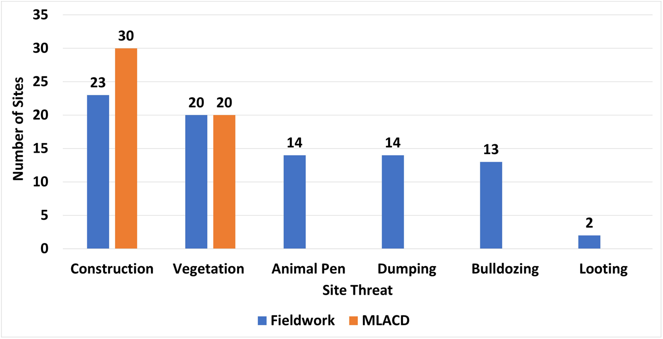
The EAMENA MLACD analysis and the fieldwork both identified several disturbances and threats to the archaeological sites in the Lefakat case study area. In addition to the primary archaeological and condition assessments, a key task of the fieldwork was to validate the EAMENA MLACD results in order to assess the accuracy and effectiveness of the remote sensing method. By validating and comparing the results of the MLACD to the observations made in the field, we can better understand the results, and identify where improvements can be made to the MLACD script in future.
The MLACD primarily detected changes related to construction activities and vegetation growth. The fieldwork was able to confirm and further document these disturbances, as well as identify several other disturbances and threats which were not identified by the MLACD, including bulldozing, looting and the re-purposing of ancient structures as animal pens (Figure 15).
Comparison between the number of disturbed heritage sites detected by the MLACD method and the documented threats observed during fieldwork in Lefakat.

The MLACD detected a change from the Bare to Vegetation class at 20 sites. The fieldwork survey recorded vegetation growth at only 15 of those sites and, in addition, they identified five different sites which had not been identified by the MLACD which were also impacted by vegetation growth (i.e. false negatives). Similarly, the MLACD detected a change in land use from Bare to Urban within the 100 m buffer zone of all the 30 heritage sites of Lefakat during the study period from February 2019 to January 2024, though the fieldwork only documented 23 sites as having been impacted by construction.
These differences in results between the remote sensing method and field observations can be explained by two reasons. The first is that the radius of the buffer zone applied by the MLACD was 100 m, which is a very large area, and the fieldwork survey and documentation often focused only on a core area of the site. This issue can be mitigated to a certain extent by also using high-resolution satellite imagery to do additional validation.
The second reason for the discrepancy is the occurrence of misclassifications, which can result in false positives or negatives. Misclassification can occur for several reasons. For example, seasonality can cause issues where areas that are classified as Bare in summer have vegetation in the winter. Shadows are also a common problem in land-use classification; in this case study, validation showed that shadows were sometimes misclassified as Vegetation.
Another known issue is the resolution of the Sentinel-2 imagery, which is 10 m per pixel. The MLACD method assigns land-use classes to each pixel of an image by measuring its spectral reflectance, which works well if the entire pixel is covered by features belonging to a specific class. However, if a single pixel contains features which belong to multiple classes, e.g. a mixture of buildings and vegetation, this will make their detection harder and can lead to misclassification. The results of this issue, known as mixed pixel, is usually that whichever feature occupies a larger portion of the pixel will determine the classification. So, for example, if a building occupies a space of 3 x 3 m (9 sq. m) within a 10 x 10 m (100 sq. m) pixel, and the rest of the area within the pixel is covered in grass (91 sq. m), that pixel will be classified as Vegetation, rather than Urban. Therefore, the building will not be detected by the MLACD and could result in a false negative.
One example of a false negative, i.e. a disturbance which was missed by the MLACD, was documented during the survey at the site of Qsur Khalita (Figure 16). The site consists of a fortified farm featuring a ditched qasr, surrounded by various structures of different sizes, including an olive-oil press and a well (Figure 16a). The MLACD successfully detected the road and a newly-constructed building and farm within the 100-metre buffer area of the site (Figure 16d), appearing on the classification change map as a change in class from ‘Bare to Urban (B–U) (Figure 16e). However, the MLACD did not detect the many scattered trees and shrubs throughout the site that were documented during field survey (Figure 16 b, c). The field survey also documented other disturbances such as bulldozing (Figure 16b), which was identified by the MLACD as part of the Urban class, since the MLACD model was not specifically trained to identify bulldozing activity.
Example of a false negative identified at Qsur Khalita (a) a ditched qasr and a small building at Qsur Khalita; (b) evidence of bulldozing and construction activity; (c) natural vegetation at the site not detected by the MLACD; (d) image showing road and modern farm within 100 m buffer zone of the site (Basemap: Google Satellite Imagery (accessed in QGIS via XYZ Tiles, September 2025); (e) classification change map produced by MLACD for the area of Qsur Khalita identifying a large area of change from Bare to Urban (in grey) on the south edge of the buffer zone.

Some misclassifications could be resolved by using higher-resolution imagery, where small features are more clearly distinguishable. The EAMENA MLACD uses Sentinel-2 imagery as the default because it is freely available to access and analyse in Google Earth Engine, whereas most higher-resolution images are not available open-access and are prohibitively expensive to purchase. The best way to reduce misclassification is to continue to refine the model by providing high-quality validation and training samples.
Conclusion
Libya’s rich archaeological heritage faces unprecedented challenges driven by conflict, rapid urbanization, agricultural activity, looting and environmental factors. The combined effects of these threats, exacerbated by political instability and environmental disasters, demand urgent and coordinated international efforts to preserve what remains of these invaluable cultural assets.
In the Lefakat case study area in particular, rapid population growth has driven significant urban expansion, which has emerged as the most critical threat to heritage sites in the region. Inadequate urban planning and weak regulatory enforcement have resulted in uncontrolled development, exacerbating pressures on cultural heritage. Both the MLACD and fieldwork assessments have confirmed that construction activities have severely affected numerous archaeological sites, with entire historic settlements being demolished for residential projects. These findings highlight the acute vulnerability of cultural heritage in rapidly urbanizing contexts, particularly in areas lacking structured preservation frameworks.
The office of the DoA in Benghazi is actively engaged in the preservation and protection of archaeological sites in the Lefakat region, responding to growing threats from modern development and land alteration. For example the site of Siret (Suwayrat) al-Thaalib is located in an area which has been heavily impacted by levelling for construction (Figure 17). Only one structure remains visible, a rectangular building (15.7 x 17.5 m), constructed with medium-to-small coursed masonry with large rough-dressed blocks at the corners and a single doorway. A defensive revetment made of small- and medium-coursed stones is also present, probably indicating its defensive nature, and to the east of the building, additional structures are present but have been heavily disturbed by recent bulldozing (Buzaian Reference Buzaian2022, Appendices 197). Due to its location in the housing project area and after the area underwent levelling operations to prepare for the development, it was fenced off and is now protected by the DoA.
General view of the site of Siret (Suwayrat) al-Thaalib, showing a protective wall constructed to shield the archaeological site area from encroaching urban development.

This case study illustrates the importance and value of combining technological tools like the MLACD with on-the-ground field surveys. One of the advantages of change detection using remote sensing and historical imagery is that it allows us to look back in time and document sites that have already been completely destroyed. The MLACD is particularly effective in detecting changes related to urban expansion and vegetation growth and is an invaluable tool for understanding and monitoring change over periods of time. Nevertheless, it is not yet able to identify consistently certain disturbances such as looting and the re-use of sites as animal pens or waste dumping grounds, which were identified during the fieldwork, emphasizing the importance of conducting in-person assessments to complement remote sensing technologies.
In summary, the EAMENA MLACD method is an essential tool for the rapid monitoring of heritage sites, providing timely data on threats and disturbances. However, the ongoing need for fieldwork remains clear, as it allows for the identification and documentation of threats that cannot be captured by remote sensing alone. The collaboration between these methodologies is critical to safeguarding Libya’s rich cultural heritage, particularly in areas like Lefakat, where rapid urbanization and human activities continue to pose significant risks.The integration of the MLACD method with fieldwork assessments provides a comprehensive and effective approach to monitoring and evaluating the complex threats faced by archaeological sites in Libya. The technique offers valuable insights into land use and environmental change, enabling the development of a more robust and reliable knowledge base for the region, while also allowing for the remote monitoring of heritage sites confronting a range of threats.
Acknowledgements
The EAMENA MLACD training and Lefakat fieldwork discussed in this paper were supported by the British Council’s Cultural Protection Fund (Grant No. LG1-0097-22). The core work of the EAMENA project is generously funded by Arcadia (2312-5142). We extend our sincere gratitude to the Libyan Department of Antiquities, particularly its Director, Dr Mohamed Faraj, the Board of Directors and Abdulmunam Abani (Head of the Training Office, DoA), for their ongoing support and collaboration with the EAMENA project. The fieldwork team comprised: Naser Alhrari, Hani Hasan Alshareef, Abdullah Muhammad Muftah and Omar Muhammad Burwis. During the period in which this work was done, the Leicester EAMENA team was led by Professor David Mattingly and, following his retirement, is now led by Professor Ruth Young. We are also grateful to EAMENA Director Dr Bill Finlayson (University of Oxford) for his ongoing support, as well as the rest of the EAMENA team. Special thanks are due to our administrative team at the University of Leicester, particularly Krupesh Mistry.


 Open access