


Introduction
The emergence in Neolithic Europe of various forms of architectural monumentality attests to these societies’ capacity to coordinate large-scale projects and to construct shared social spaces (Müller Reference Müller and Osborne2014). The notion of monumentality, which is most often associated with megalithism, also includes the ditched enclosures linked to Linearbandkeramik (LBK) settlements that first appeared in the Early Neolithic of Western Europe (Petrasch Reference Petrasch, Fowler, Harding and Hofmann2015). It was only during the Middle Neolithic, from the mid fifth millennium BC, however, that large, causewayed enclosures first appeared in northern Germany and France in particular (Müller Reference Müller and Osborne2014; Dubouloz Reference Dubouloz, Gandelin, Ard, Vaquer and Jallot2018). More recently, mid fifth-millennium enclosures have been discovered on the Atlantic coast of France, coinciding with the construction of the first megaliths in that region (Laporte et al. Reference Laporte2015). Several studies have focused on the spatial and chronological relationships between enclosures and megaliths—mainly those from the fourth millennium BC—in England and Germany (Darvill Reference Darvill, Ard and Pillot2016; Hinz Reference Hinz, Ard, Mens and Gandelin2021), as well as the well-known example of the Sarup region in Denmark (Andersen Reference Andersen, Muller, Hinz and Wunderlich2019).
In order to understand the contexts within which these enclosures first emerged, and their relationship with megalithism, our research focuses on west-central France, recognised as one of the earliest centres of megalithic construction in Atlantic Europe (Laporte et al. Reference Laporte, Jallot and Sohn2011; Joussaume Reference Joussaume2016). Erected as early as the mid fifth millennium BC (Middle Neolithic; 4700–3700 BC), today these megalithic monuments are found individually, scattered across the landscape, or grouped, such as at Bougon (Mohen & Scarre Reference Mohen and Scarre2002). The northern part of the Charente department, in particular, features one of the most important concentrations of dolmens in western France (Joussaume et al. Reference Joussaume, Laporte and Scarre1998; Ard et al. Reference Ard, Muller, Hinz and Wunderlich2019). This concentration includes dolmens of a unique architectural form (the Angoumoisin type) and long barrows that are among the most imposing known in Neolithic Europe (Laporte et al. Reference Laporte, Lopez-Romero, Bernard, Robin, D'Anna, Schmitt and Bailly2014; Ard et al. Reference Ard2016b, Reference Ard, Ard, Mens and Gandelin2021). Mainly studied at the end of the nineteenth century, however, the structures and development of these monuments remain largely unknown.
For more than a century, archaeologists have sought, without success, to locate the habitational settlements contemporaneous with these earliest megalith monuments. While west-central France includes one of the largest concentrations of causewayed enclosures in Europe (Joussaume et al. Reference Joussaume2014), with over 300 sites recorded, the material culture and dating evidence obtained over the span of several decades of research place their emergence approximately one millennium later than the date of the megaliths (i.e. in the Late/Final Neolithic; 3700–2200 BC). Moreover, in the absence of any known structures within these enclosures, their habitational function remains the focus of debate (Burnez & Louboutin Reference Burnez, Louboutin, Varndell and Topping2002).
As a result, fundamental questions about how the megaliths were integrated into the landscape and about the location and form of contemporaneous settlements that housed the builders of these monuments have yet to be properly explored. To address these questions, a collaborative research programme was initiated in 2013, and expanded and continued via the ANR MONUMEN project between 2018 and 2022. The aim of this programme is to compare the two forms of monumental architecture—megaliths and enclosures—in order to clarify their emergence and development between the mid fifth and the end of the third millennium BC (Ard et al. Reference Ard, Ard, Mens and Gandelin2021). The study area, between the Loire, Massif Central and Pyrenees, constitutes a sort of reference laboratory on account of its abundance and diversity of known monumental sites. Starting with an interdisciplinary approach (using archaeology, architectural study, geoarchaeology and bioarchaeology), and with a particular emphasis on non-invasive methods (including photogrammetry, 3D laser scanning, geophysical survey, LiDAR and photogrammetry with drone photo coverage), the project seeks to identify the technical and cultural choices of the megalith builders (Ard et al. Reference Ard, Ard, Mens and Gandelin2021).
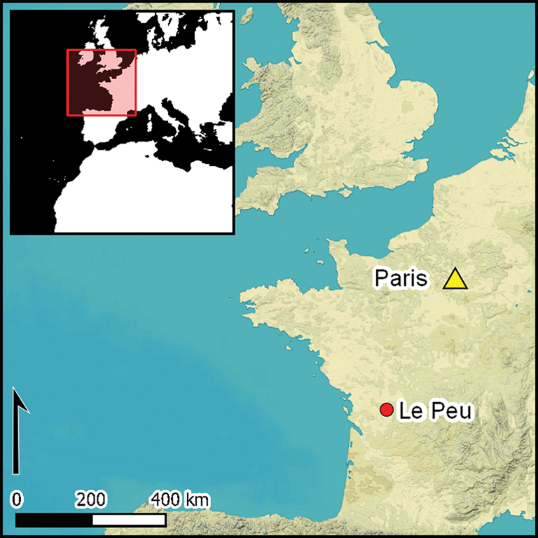
The application of these methods to the study of the enclosures has yielded unprecedented data regarding the settlement or habitational sites of the first megalith builders. The enclosure of Le Peu at Charmé, Charente, is a case in point. Located on a limestone promontory, it is only 2.5km south-west of the Tusson cemetery, which consists of an alignment of five long mounds, and is among the most imposing known in Europe at 139m long (although it remains unexcavated; Ard et al. Reference Ard2016b, Reference Ard, Ard, Mens and Gandelin2021). Our work at Le Peu establishes the site as unique in Atlantic Europe thanks to its Middle Neolithic date, as well as the defensive aspect of its ditch system and the presence of buildings within the enclosure. Moreover, by demonstrating the contemporaneous emergence of megaliths and enclosures as early as the mid fifth millennium on the Atlantic coast, we overturn the consensus that these two forms of monumental architecture developed separately.
A multi-method and multi-proxy approach
The enclosure at Le Peu was discovered by aerial survey in 2011 (Ard et al. Reference Ard2016a). Aerial photographs allow us to distinguish two interrupted parallel and curvilinear ditches across the western end of the promontory (Figure 1b), with the innermost ditch interpreted as a palisade trench. A break in the external ditch is clearly visible at the northern end, at which point a ‘crab claw’ entranceway extends outwards—something that is unique for the Middle Neolithic.
Charmé, Le Peu, Charente, France: a) location and Neolithic environment of the enclosure (GIS: A. Laurent; ©IGN RGE 5 m 2021; database ANR MONUMEN); b) aerial photograph of the site (E. Bouchet, 2011); c) digital terrain model of the enclosure environment (GIS: A. Laurent; ©IGN RGE 5 m 2021).

Geomagnetic survey of the enclosure, carried out with a FEREX gradiometer (Foerster Institüt) and with a G858 magnetometer (Geometric) for targeted areas, has revealed a complete plan of the enclosure, including evidence for a second crab claw entranceway, multiple breaks in the southern part of the external ditch, and several anomalies within the interior (to the east) (Figure 2). Posthole-type anomalies at the highest point of the promontory suggest the presence of four quadrangular buildings—a form previously completely unknown in this region of France. The results of the geomagnetic survey were used to determine the location of trenches for excavation, undertaken between 2014 and 2021, to investigate the two crab claw entrances, the ditch and the palisade trench, as well as some of the anomalies within the enclosure (Figure 2). In addition, outside the enclosed area, an extension of the geomagnetic survey to the west revealed three further small buildings similar in plan to those identified within the enclosure. Excavation to establish the function and date of these three small buildings has been conducted in 2022.
Magnetic mapping of the enclosure of Le Peu and location of excavation trenches (geophysical acquisition: G. Bruniaux, V. Legrand, F. Lévêque, F. Lüth and V. Mathé; GIS and CAD: V.-E. Leroux and H. Vitté).

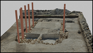
Excavation has revealed that the quadrangular buildings detected on the highest part of the promontory lie directly beneath the current plough zone (at a depth of approximately 0.2m), whereas the lower part of the slope is covered by nearly 1m of sediment. The potential for good preservation in a context where occupation layers are rarely preserved favoured the application of environmental and geoarchaeological methods. Our aim was to document the landscape framework of this Neolithic occupation using geomorphology to characterise the formation processes of the sedimentary deposits and the evolution of the surrounding terrain over time. This approach was complemented by bioarchaeological analyses (palynology, anthracology and malacology) to characterise the vegetation and the wider environment. To this end, 27 trenches were machine stripped from the mid-slope to the lower areas, first on the northern slope and then on the southern and eastern slope, allowing the sedimentary deposits to be traced over an area of more than 6800m2 (Figure 2). A 3D reconstruction of the enclosure and of its buildings in their landscape context was subsequently created by Archeotransfert.
An enclosure on the edge of a marsh
The enclosure is located on a Late Jurassic limestone promontory measuring 700m long and 275m wide (Cariou & Gabilly Reference Cariou and Gabilly1973), situated above a valley that drains the Bief stream to the east. The site is positioned at an elevation of approximately 75–80m asl, flanked to the north and south by shallow, flat, dry valleys (Figure 3a). The western side of the enclosure passes through a shallow col, enhancing a natural boundary that limits access to the promontory from the west, while the other slopes were surrounded by a horseshoe-shaped marsh (Figure 1c).
Charmé, Le Peu (Charente, France): a) 3D block showing the local geological and geomorphological context of the study area (extract from the BRGM 1:50 000 geological map of France and IGN RGE-ALTI-5m) (GIS and CAD: G. Dandurand); b) 2019 survey of the stratigraphic section from trench Tr. 20 (drawing and CAD: G. Dandurand and M. Onfray); c) detail of the northern part of the trench 20 section (photograph: M. Onfray).

The different trenches excavated along the slopes to the north, east and south highlight a pedo-sedimentary sequence that can be summarised into five main chrono-stratigraphic phases, some of which have been radiocarbon dated (Figure 3b–c). The base of the sequence is composed of colluvial-alluvial formations (Ng) and reworked calcareous grit (Gr), remobilised weathering products and fragments of marly limestone (J6). This sedimentation may correspond to the extremely cold and dry climatic conditions during the last stages of the Weichselian Late Pleniglacial (MIS 2; 23 000–13 000 BC), a period characterised by climatic oscillations that led to solifluction and the reworking of calcareous grit (Bertran et al. Reference Bertran1992). The deposits then underwent strong erosion and remobilisation (Ng) through to the beginning of the Holocene (Younger Dryas transition/Preboreal 9000–7000 BC).
A dark palaeosol (P) of peaty appearance was deposited on top of the calcareous grit during the Boreal–Atlantic climatic optimum (7000–3700 BC). This reflects a more temperate and humid climate, favouring the development of denser vegetation cover in biostatic equilibrium. The landscape became more closed, with waterways carrying more materials, and the water table and flood levels higher. Consequently, the lowest areas would have been flooded for at least part of the year. It was during this period that the enclosure and associated features were constructed, and ceramic and lithic artefacts dating to the Middle Neolithic were retrieved from these sediments.
The third phase corresponds to the generalised erosion of this palaeosol (Truncation T1 on Figure 3b), which is nearly 0.8m thick at the highest point of the promontory. It remains unclear whether this erosion began at the end of the Atlantic optimum or took place during the Subboreal (2500–700 BC). Nonetheless, it appears to be contemporaneous with clogging of the talweg bottoms with overflow silts (Ls–Sl) and a progradation of tuffaceous and carbonate deposits (St–Lc) linked to cool and dry palaeoclimatic conditions. The residual presence of a few lithics attributed to the Neolithic in secondary contexts within level 3coll, however, seems to support the hypothesis of generalised erosion during the Subboreal.
The fourth phase corresponds to colluvial detrital formations (2coll and 1coll), which were created by accelerating erosion of the top of the promontory caused by clearance and intensive cultivation from the Sub-Atlantic period onwards (700 BC). Truncation T2 (Figure 3b), highlighted by a layer of limestone pebbles, relates to an increase in anthropic pressure and/or climatic deterioration during the Little Ice Age (AD 1300–1700). Finally, recent ploughing and other subsoil activities have destroyed the lower horizons, and the mechanisation of agriculture over the last few decades has further accelerated this process of soil erosion.
The excellent preservation of shell at the site permits us to conduct a malacological analysis to identify the vegetational environment around the marsh contemporaneous with occupation of the enclosure (Figure 4). The results from trench 4 indicate a significant increase in the proportions of aquatic species within palaeosol (P), with a high frequency of pill clams (Pisidium subtruncatum), which suggest slow-moving or standing water. Among the terrestrial species identified, those favouring closed environments are better represented than mesophilic species. The proportion of species associated with open environments progressively decreases throughout the Middle Neolithic compared with those favouring palustrine environments, even if the latter remain low. This suggests that the riparian edges were not colonised by palustrine vegetation, and were probably dry and wooded. Despite the poor preservation of pollen, analysis of the palaeosol (P) from trench 2 provides additional information regarding vegetation. Pollen at the base of the palaeosol attests to an open, mixed oak forest (Quercus, Corylus, Ulmus and Tilia). During the Neolithic period, the valley was occupied by marsh or riparian vegetation dominated by the Cyperaceae family. The persistence of a high water table is also confirmed by the prevalence of an aquatic species of the Potamogeton family. On well-drained soils, the abundance of Poaceae and the presence of ruderal plants (e.g. Chenopodiaceae, Caryophyllaceae and lanceolate plantains) indicate anthropic prairie formations.
3D reconstructions of the enclosure of Le Peu and its environment from archaeological data (© Archeovision Production 2018).

A monumental and possibly defensive enclosure
The promontory is blocked to the west by a shallow, U-shaped ditch (St. 1), 4–5m wide, diminishing in depth as it rises to its highest point, where the erosion is greatest (Figure 5). The depth of the ditch does not exceed 1m and its fill presents a succession of silty-clay layers. Only a few artefacts of a regionally undefined early Middle Neolithic cultural sphere were recovered from the ditch. Parallel to the ditch, at a distance of 4–5m inside the enclosure, was a parallel double-palisade trench (St. 2), within which oak posts (150–300mm in diameter)—identified via charcoal remains—were set in place with (extant) packing stones (Figure 5). These timber double palisades, the heights of which are impossible to estimate, contributed along with the ditch to the monumental character of the enclosure. Radiometric analysis dates the digging of the outer ditch and double palisade trench to c. 4400 BC (Figure 6; see also Table S1 in the online supplementary material (OSM)). A date obtained on a bone sample from the upper levels of the outer ditch fill attests to the latter's use until the beginning of the fourth millennium (Beta-447613: 5080±30 BP). This architectural configuration—an outer ditch with one or two palisades—has only recently been identified (Soler Reference Soler and Joussaume2014), but now appears characteristic of Middle Neolithic enclosures in west-central France, and reflects an increase in the wider documentation of architecture related to this period in northern and southern France (Gandelin Reference Gandelin2011; Dubouloz Reference Dubouloz, Gandelin, Ard, Vaquer and Jallot2018).
Plan of one of the monumental entrances of the enclosure of Le Peu excavated in trench 17 and details of test pits in the external ditch St. 1 (top) and in the double palisade trench St. 2 (bottom) (CAD and photographs: V. Ard).

Charmé, Le Peu (Charente, France). Diagram of all radiometric dates obtained for the different types of structures built during the Middle Neolithic, produced using OxCal v4.4.4 (Bronk Ramsey Reference Bronk Ramsey2021) and calibrated using atmospheric data from Reimer et al. (Reference Reimer2020) (CAD and illustrations: V. Ard).

Extensive excavation of Le Peu has revealed that this ditch/palisade arrangement on the western side of the enclosure is completed on the northern, eastern and southern slopes of the promontory by a double wooden palisade trench running along the edge of the marsh, surrounding an area of nearly 6ha (Figure 4). Nearby, activity areas are evidenced by the discovery of bone, lithic and ceramic remains, as well as pits and hearths within the palaeosol (P) attributed to the Middle Neolithic.
Two exceptional features, described here as entrance structures, accentuate the monumentality of the enclosure, for which there is currently no known fifth-millennium BC equivalent along the Atlantic façade (Figure 7). These features were discovered during the excavation of the two ‘crab claw’ entrances through the outer ditch (St. 3 & 125). Crab claw entranceways are considered characteristic of the regional Late Neolithic during the third millennium (Burnez & Louboutin Reference Burnez, Louboutin, Varndell and Topping2002) and have been dated to the beginning of the Late Neolithic (c. 3650 BC) at the nearby Bellevue enclosure at Chenommet (Ard Reference Ard2022). Dating on charcoal from the fill of St. 125 at Le Peu (Beta-594523: 5120±30 BP) indicates that it was dug as early as the Middle Neolithic, making it the oldest known example in west-central France. In contrast with the best known Late/Final Neolithic examples, however, the Le Peu crab claws are formed by single, rather than paired, curving ditches placed either side of the break in the enclosure ditch. In the absence of extensively excavated enclosures of the same date, it remains to be seen whether this is a regional characteristic; however, two crab claw entrances, analogous to Late Neolithic examples, have recently been found at the Achenheim enclosure in Lower Alsace, in north-eastern France, dated to the end of the fifth millennium BC (Lefranc et al. Reference Lefranc2021).
Plans and views of the two monumental buildings' entrances protected by ‘crab claw’ arrangements (CAD: V. Ard; orthophotography and 3D model: A. Laurent).

The excavation of the north-west crab claw (St. 3) led to the discovery of a post-built structure of horseshoe-shaped plan (St. 134), projecting from the double palisade (St. 2) (Figure 7). The structure overlies the infilled outer ditch (St. 1). Orientated south-east to north-west, the structure measures 5.4–5.8 × 7.4–7.9m, delimiting an area of approximately 40m2. The structure is formed by a continuous trench in which posts were set in place using limestone blocks. The trench measured 0.7–1.1m wide, with a maximum depth of 0.8m, and was filled with brown-yellow clay sediment. Two 1.5m-wide spaces where the trench is shallower (0.3m), closest to the palisade trench (St. 2), may correspond to entrances into the structure. Here, the depth of the post trench and the massive nature of the limestone blocks used to hold timber posts in place attest to the monumentality of this feature, which we interpret as an entrance structure. Excavation of the second crab claw (St. 125), further south and not far from the highest point of the promontory, led to the discovery of a second entrance building (St. 126), with dimensions comparable to St. 134: 7.8 × 6.4m (Figure 7). The continuous trench, with a depth of 0.5m, delimiting this second entrance building, featured a series of approximately 20 carbonised ‘ghosts’ of posts 0.2–0.3m in diameter and must have been supported, like St. 134, by the double internal palisade (St. 2).
To the south, St. 126 intersects with the ditch (St. 1). Charcoal samples from these features (St. 3 & 126) date to the mid fifth millennium BC (Figure 6), attesting to their early construction in the occupation sequence. The digging of these features, which required infilling the ditch (St. 1), could attest to a need to reinforce the protection of the entrances. Although there is no direct stratigraphic relationship between them, the spacing between the crab claws and the entrance buildings, the fact that both post-date the St. 1 ditch, and the positioning of the crab claws as if to protect the buildings, all suggest that they were constructed simultaneously or within a short period of time. Moreover, the location of these structures at the main entrances to the enclosure, their probable height (given the depth of the foundation trench and the massive size of the packing stones), and their association with the crab claws, all attest to an ostentatious function. We could potentially describe them as ‘bastions’, in reference to the examples known from later protohistoric and historic periods (Keeley et al. Reference Keeley, Fontana and Quick2007). While the delimitation of a social space (Müller Reference Müller and Osborne2014) may have been the primary function of the enclosure, the addition of the bastions and crab claw entrance in a second phase may suggest a new need for defence (Keeley et al. Reference Keeley, Fontana and Quick2007). A defensive function is apparent at many Late and Final Neolithic enclosures in the region, as evidenced by, for example, the narrowness of entrance passages, the use of chicanes, and the erection of banks alongside ditches (Ard Reference Ard2022).
The oldest buildings of west-central France
The search for traces of habitational settlement was one of the major objectives of the extensive geomagnetic survey of the interior of the enclosure. The discovery of evidence for at least three buildings has permitted the excavation of the oldest rectangular buildings known in west-central France (Figures 2 & 8). Located at the point of the promontory, the occupation levels of these buildings have completely disappeared due to erosion and only postholes are preserved. All the buildings show traces of combustion, attesting to their destruction by fire c. 4400 BC (Figure 6).
Plans of the four Middle Neolithic buildings discovered inside the enclosure of Le Peu at the top of the promontory (CAD: V. Ard; 3D reconstruction: Archeovision Production).

Building 1 is 13 × 9m. Orientated almost east–west, it is defined by 16 postholes with diameters, at the top, of between 0.6 and 1m, and a surviving depth of 0.3–0.5m. The arrangement of the extant packing stones allows the diameter of the posts to be estimated as between 0.25 and 0.40m. As was the case for the palisades, the wood used was deciduous oak, as indicated by charcoal.
Nearby, traces of a second building, not detected during the geomagnetic survey, were discovered during mechanical stripping. This building was located close to numerous pits containing lithic and ceramic material. Building 2 is orientated south-west–north-east and is defined by 10 postholes with similar diameters to those of building 1 (0.6–1.1m), with the exception of the posthole at the eastern wall, which is much larger (2.2m in diameter). The postholes are, however, shallow (0.25–0.4m) and the packing stones rarely preserved.
The other two buildings (3 and 4), located further east, are of comparable dimensions to buildings 1 and 2. Building 3 measures 13 × 8.5m and has a similar orientation to building 1. It is defined by 10 postholes. Building 4, on the other hand, is more unusual, being square in shape (10 × 10m); as in the case of building 2, a posthole on the eastern wall is much larger and slightly out of line with the rest of the wall. Otherwise, the dimensions of the postholes and posts of building 3 and 4 are comparable to buildings 1 and 2. The four buildings are of similar date (Figure 6), pointing to construction during the earliest phase of the enclosure.
Architecturally, buildings 1–3 bear strong similarities. They feature load-bearing posts on the sides only and a central post in the eastern wall that protrudes slightly from the wall line, in contrast with the western wall, where it is somewhat recessed. Based on these observations for buildings 1–3, we present a reconstruction of one of the buildings in Figure 8 (due to lack of information, building 4 could not be reconstructed). The structure of the buildings consists of a system of four porticoes. Inside building 1, traces of small posts were identified, suggesting the presence of a raised platform that could accommodate a sleeping or kitchen area. Longitudinal timbers will have supported closely spaced rafters, which, in turn, supported a roof that was probably covered with bark or thatch. Daub debris in the posthole fills indicates wattle-and-daub walls. Currently, these buildings have no regional comparison; the recently discovered monumental building at Aytré, Charente-Maritime, dated to the Middle Neolithic, has much larger dimensions (approximately 50 × 20m) and a central row of ridge beams (P. Fouéré, pers. comm.).
An alternative form of monumentalism in the world of the living
The discovery of the Le Peu enclosure in the heart of one of the centres of early Atlantic megalithism is a breakthrough that attests to the parallel development of two forms of monumentalism during the mid fifth millennium BC: an enclosure for the living and megalithic tombs for the dead. Only 2.5km from Le Peu, the five long mounds of the Tusson cemetery lie on a direct line of sight to the promontory that is surrounded by the Le Peu enclosure (Figure 9). The relationship between these two sites is therefore brought into question, even though it is currently impossible to determine whether Le Peu was home to the builders of these megalithic monuments. As the latter have not been investigated, within the framework of the ANR MONUMEN project we have sought to date the construction of these megalithic monuments by searching for their quarries using geomagnetic surveys (Mathé et al. Reference Mathé, Legrand, Camus, Ard, Ard, Mens and Gandelin2021).
Tusson, Gros Dognon (Charente, France): a) location of the long barrows in relation to Le Peu enclosure (GIS: A. Laurent; ©IGN RGE 5 m 2021); b) LiDAR survey of the monument and magnetic mapping of its environment revealing the existence of a number of pit quarries (acquisition and processing: A. Laurent, F. Lüth, N. Poirier and V. Mathé).

The results of these surveys indicate hundreds of subcircular magnetic anomalies around the tumuli, most approximately 3m in diameter, as well as more linear features up to 10m in length (Figure 9). Excavation has revealed that these anomalies relate to Neolithic quarries dug in the form of circular shafts, sometimes merging together (Ard et al. Reference Ard, Ard, Mens and Gandelin2021). The cleaning of an old section that cut the Petit Dognon long mound confirms that some of the Tusson tumuli were built with materials from these quarries (Ph. Gouézin excavations, 2020). Once the extraction of stone was complete, one or more deer antlers were deposited—probably intentionally—at the bottom of each shaft. This phenomenon is also documented at quarries related to other regional monuments, although these have so far seen little investigation (Mohen & Scarre Reference Mohen and Scarre2002; Laporte Reference Laporte, Guyodo and Mens2013). In total, 13 antlers have been radiocarbon dated, helping to determine the period in which these quarries were exploited and thus, indirectly, dating the initial construction stages of the megalithic structures, for which we currently have no associated archaeological finds. The results indicate that these quarries were in operation as early as 4600 BC, with intense exploitation between 4350 and 4080 BC—synchronous with the main occupation of Le Peu. Moreover, as with the neighbouring Motte de la Jacquille monument at Fontenille, Charente (Ard et al. Reference Ard2016b), the location of the quarries in relation to the megalithic monuments is significant. The quarries surround the Petit and Gros Dognon long mounds that form two or three parallel and discontinuous lines, which resemble interrupted enclosure ditches. The forms and techniques used to construct both the quarries/megaliths and the enclosure at Le Peu thus appear to be similar.
Conclusion
Following a sustained programme of research, Le Peu now constitutes a reference site through which to explore the emergence of the earliest monumental structures in Atlantic Europe and the communities who built them. On account of its architecture, date and traces of buildings of possible residential function, Le Peu currently has no Middle Neolithic equivalent in west-central France. It must, however, be studied in context, and further geophysical survey has already identified three new enclosures close to Charmé, within a 2km radius of Le Peu (Figure 10). Assessment of these three sites indicates their occupation during different periods, following the abandonment of Le Peu. The dynamics of occupation within this micro-territory and its environment are thus beginning to emerge over time.
Charmé (Charente, France): Neolithic enclosures discovered in the environment of Le Peu by extensive magnetic survey (geophysical acquisition: F. Lüth; GIS: A. Laurent; ©IGN RGE 5 m 2021).

The discovery and excavation of the Le Peu enclosure offers a picture of the settlements of the first megalith builders, where wood and earth were the preferred building materials, while stone dominated in the world of the dead. The desire to protect the community with defensive architecture also marks a turning point in the social tensions that characterise the middle of the fifth millennium BC in Western Europe.
Acknowledgements
We warmly thank the owners of the fields, as well as all the collaborators and volunteers who participated in the field research. Many thanks to Mélanie Lacan for the English translation.
Funding statement
This research was financed by grants from the Ministry of Culture (Regional Archaeology Service of DRAC Nouvelle Aquitaine), the Charente department and the French National Research Agency (ANR) via the MONUMEN project: Monumentality, Landscapes and Social Competitions during the Neolithic in Atlantic Europe (ANR-17-CE27-0009).
Supplementary material
To view supplementary material for this article, please visit https://doi.org/10.15184/aqy.2022.169.


 Open access