





Policy Significance Statement
The contrast between domestic workers’ maps and public transportation official maps furthers understanding of how expert cartography has ignored the challenges of actual users (Harley, Reference Harley2002; MacEachren, Reference MacEachren2004; Elwood, Reference Elwood2009; Kennedy et al., Reference Kennedy, Hill, Aiello and Allen2016; Vaughan, Reference Vaughan2018) and how feminist approaches could benefit them (Haraway, Reference Haraway1991; Townsend, Reference Townsend1991; Rose, Reference Rose1993; Kwan, Reference Kwan2002). Proper access to information on mobility systems enhances users’ RtC (World Social Forum, 2004). This article is relevant for transport policymakers because it highlights the gap between how they map the city and how users understand and map the city based on their experiences and knowledge, considering that these users—domestic workers—are 13 million wage working women in Latin America and captive to public transit (International Labour Organization (ILO), 2021). It recommends combining experts’ mapping techniques with users’ street-level approaches in built and projected transportation systems.
1. Introduction
While conducting fieldwork in 2017 in a run-down building that houses the Escuela Nacional Sindical (ENS) in Medellín, I interviewed a domestic worker of the Afro-Colombian Domestic Workers’ Union (UTRASD). I asked her to draw her commute on a map of Medellín with its respective districts (comunas in Spanish). The map had the shape of the city divided by lines into multiple districts and legally assigned numbers. She froze. She could not trace her route because she did not know how to represent it on that map.
In 2018, in a spacious office on a high floor of a building located in Bogotá’s financial district, while turning off the recorder, I described to the expert some of my preliminary findings on domestic workers’ mobility: highly racialized and impoverished women who constitute one in five wage working women in Latin America, and massive captive users of the region’s public transit systems, with 83% traversing Colombian cities every day (Osorio Pérez, Reference Osorio Pérez2018; International Labour Organization, 2021). I told him about the maps they had drawn of their commutes in Bogotá and Medellín. He asked to see them. Shocked, he widened his eyes, calling another consultant. The expert told him while pointing to one of the maps on a blank piece of paper: “Do you see? That is why users do not understand the maps we make for them”.
These stories represent two sides of the same coin. The city that domestic workers inhabit, how they situate themselves and imagine it from the street level, distances from the expert gaze that literally and metaphorically observes and draws the city from above. This gap in experiences and representation reveals the hierarchy and the lack of response to the mobility needs of domestic workers and their limited access to the RtC. It interrogates how current transportation systems are planned today and for whom. It hints at why mass public transportation systems that should enhance quality mobility for millions of primarily middle- and low-income Latin Americans ignore them, while informal modes tailored to users’ needs constantly threaten formal mobility systems in place.
This article seeks to tell the story of this gap, why it occurs, the negative impact on domestic workers’ RtC—and similarly situated commuters—, and how to close it. It begins by describing the literature on mapping techniques that detach from the lives of ordinary citizens; the concept of RtC; its connection to transport accessibility that intersects with race, class, gender, and other sources of vulnerability; and the discussions around feminist geography and its relationship with cartography. Then, it describes the qualitative methodology used.
The central argument is twofold in response to the following statement: “Cartography has historically been associated with positivist forms of knowledge production and may help answer questions about what and where. Feminist methodologies are associated with qualitative research and can best answer questions about why and how” (Ricker et al., Reference Ricker, Kraak, Engelhardt, Engebretsen and Kennedy2020:410). Part one analyzes two “expert” maps of Bogotá and Medellín’s transport systems, following the logic of modernization and rationalization. Part two analyzes the maps of domestic workers’ daily commutes, considering their educational level, arrival in the big city from rural Colombia, and how they learned to move around. Part three delves into the implications of the gap for their effective enjoyment of RtC. It provides public policy recommendations addressing the gap.
1.1. Literature: Cartographies and RtC for all
Maps are a coded representation of reality based on specific information and illustrated by lines, colors, textures, and conventions (Desimini, Reference Desimini, Coomans, Cattoor and De Jonge2019:19). When designed effectively, maps tell stories, provide dynamic information about geographic patterns at multiple scales, and show trends across various time scales (Ricker et al., Reference Ricker, Kraak, Engelhardt, Engebretsen and Kennedy2020). They usefully capture data and provide a starting point to statistically analyze it visually (Vaughan, Reference Vaughan2018:7). A map should help whoever reads and uses it to understand a concept or idea quickly, and it should be legible (Lynch, Reference Lynch1960; Ricker et al., Reference Ricker, Kraak, Engelhardt, Engebretsen and Kennedy2020).
Different types of maps exist. Topographic maps implicitly show various large-scale physical phenomena. Currently, these maps build on both accessible data and personal data that are ground-truthing (Desimini, Reference Desimini, Coomans, Cattoor and De Jonge2019:19). They require a legend, and understanding them demands looking at the legend and the drawing several times. It allows us to accurately read the geomorphology, material, and occupation of space so that a person can grasp scaled information (Desimini, Reference Desimini, Coomans, Cattoor and De Jonge2019:19). Geographic maps use distant media to describe the entire world (Harvey, Reference Harvey1980). Topological maps place critical points on a path, such as the maps of public transportation systems (Desimini, Reference Desimini, Coomans, Cattoor and De Jonge2019). Thematic maps focus on a single feature and usually geo-locate statistical information (Desimini, Reference Desimini, Coomans, Cattoor and De Jonge2019:19). Social cartography maps represent specific social aspects at a concrete time and space (Vaughan, Reference Vaughan2018:1).
Some experts have erroneously conveyed maps as objective and transparent. Institutional mapping presupposes the world can be measured through exact and objective procedures (Ferdinand, Reference Ferdinand, Dibazar and Naeff2018:139). However, maps often contain errors; people with individual positionalities and epistemologies, who undergo interrelated processes and negotiations, create them (Elwood, Reference Elwood2009; Kennedy et al., Reference Kennedy, Hill, Aiello and Allen2016; Pavlovskaya, Reference Pavlovskaya2018; Vaughan, Reference Vaughan2018). The database, the missing relevant data, who is included or excluded in the information, and the editing details involve crucial decisions in a map’s final design (Pavlovskaya and St. Martin, Reference Pavlovskaya and St. Martin2007; Ricker et al., Reference Ricker, Kraak, Engelhardt, Engebretsen and Kennedy2020). They manifest power and authority over the truth, which offers direct and indirect messages through representations and symbols (Wood, Reference Wood1992; Pickles, Reference Pickles1995; MacEachren, Reference MacEachren2004). Maps are “preeminently a language of power, not protest” (Harley, Reference Harley2002:79). Although maps distort time and space (Desimini, Reference Desimini, Coomans, Cattoor and De Jonge2019:17), their value as scientific objects lies in the scale’s precision and other similar measuring factors (Vaughan, Reference Vaughan2018).
Maps from above, like “God’s eye,” contrast with maps from the ground, those experienced through one’s body. The panoptic visualization of watching over the city takes distance and makes it readable from above (Ferdinand, Reference Ferdinand, Dibazar and Naeff2018). “God’s eye” maps separate the experts who create them and users who read them from the streets that manifest complex situated practices, allowing them to grasp the urban geographies without grabbing them (Ferdinand, Reference Ferdinand, Dibazar and Naeff2018:145). Aerial views reduce urban environments to transparent texts, promoting rational interventions from afar (Ferdinand, Reference Ferdinand, Dibazar and Naeff2018:145). The idea of maps’ objectivity precisely comes from this exercise of taking distance. However, feminist geography considers “God’s eye” authoritative, unquestionable, and objective, although cartographers know that making a map entails constant indeterminacy (Ricker et al., Reference Ricker, Kraak, Engelhardt, Engebretsen and Kennedy2020:410).
Recently, scholars have argued that disseminating digital cartography has democratized this epistemology, engaging many non-traditional experts in map creation (Crampton, Reference Crampton2010; Della Dora, Reference Della Dora2012). Other authors contend that this supposed democratization of cartographic practices adds these non-experts to conventional cartographic knowledge (Ferdinand, Reference Ferdinand, Dibazar and Naeff2018:149). Hence, we should inquire who has the knowledge and resources to access open digital data, especially in places with low digital literacy, who can create visual roadmaps to inhabit cities.
Modern urbanism considers the street a subordinate and disorderly social site that cartographers and planners must order from above through rational mechanisms (Ferdinand, Reference Ferdinand, Dibazar and Naeff2018:138). However, in contrast to “God’s eye” maps (Figure 1 Left), street-level maps have relevant features speaking specifically to the citizens who inhabit them and their complex social dynamics (Figure 1 right).
Example of street-level map vs. example of aerial map. Left panel: Invisible Commutes (2017–2018) Mapa 20: Medellín. Available at: https://www.invisiblecommutes.com/mapas. © Invisible Commutes. All rights reserved. Right panel: Pavel Afanasov (2023) Tbilisi GE. Old Tbilisi in Open Aerial Map available at: https://map.openaerialmap.org/#/-18.720703125,18.562947442888312,3/latest/65362aaefbe6460001057d56?_k=heeum1. Available under a CC-BY License. © Invisible Commutes. All rights reserved.
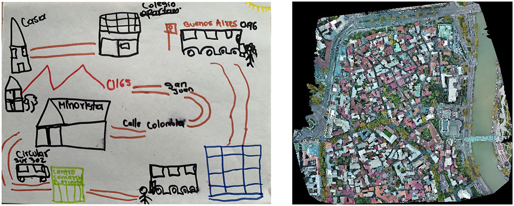
One of these features relates to people’s familiarity with a particular urban environment. When Kevin Lynch was studying Boston, he found that how people matched with the city elements was subjective (Lynch, Reference Lynch1960). While for those who knew less about Boston, the city was its topography, great regions, and general characteristics; those who knew it some more considered specific routes and their interrelationships; and those who knew it best were based on particular urban landmarks (Lynch, Reference Lynch1960:49).
Likewise, grounding the map permits departing from institutional limits (Ferdinand, Reference Ferdinand, Dibazar and Naeff2018). Artist Jeremy Wood transforms the body of the walker into a “geodesic pencil” that inscribes urban landscapes as he traverses them (Ferdinand, Reference Ferdinand, Dibazar and Naeff2018:138). Wood’s maps make streets and their citizens the sites and agents of cartographic practice, empowering pedestrians since walking becomes an iterated performance of making and remaking streets (Ferdinand, Reference Ferdinand, Dibazar and Naeff2018:138 and 139). His maps document spatial realities and daily rhythms (Ferdinand, Reference Ferdinand, Dibazar and Naeff2018).
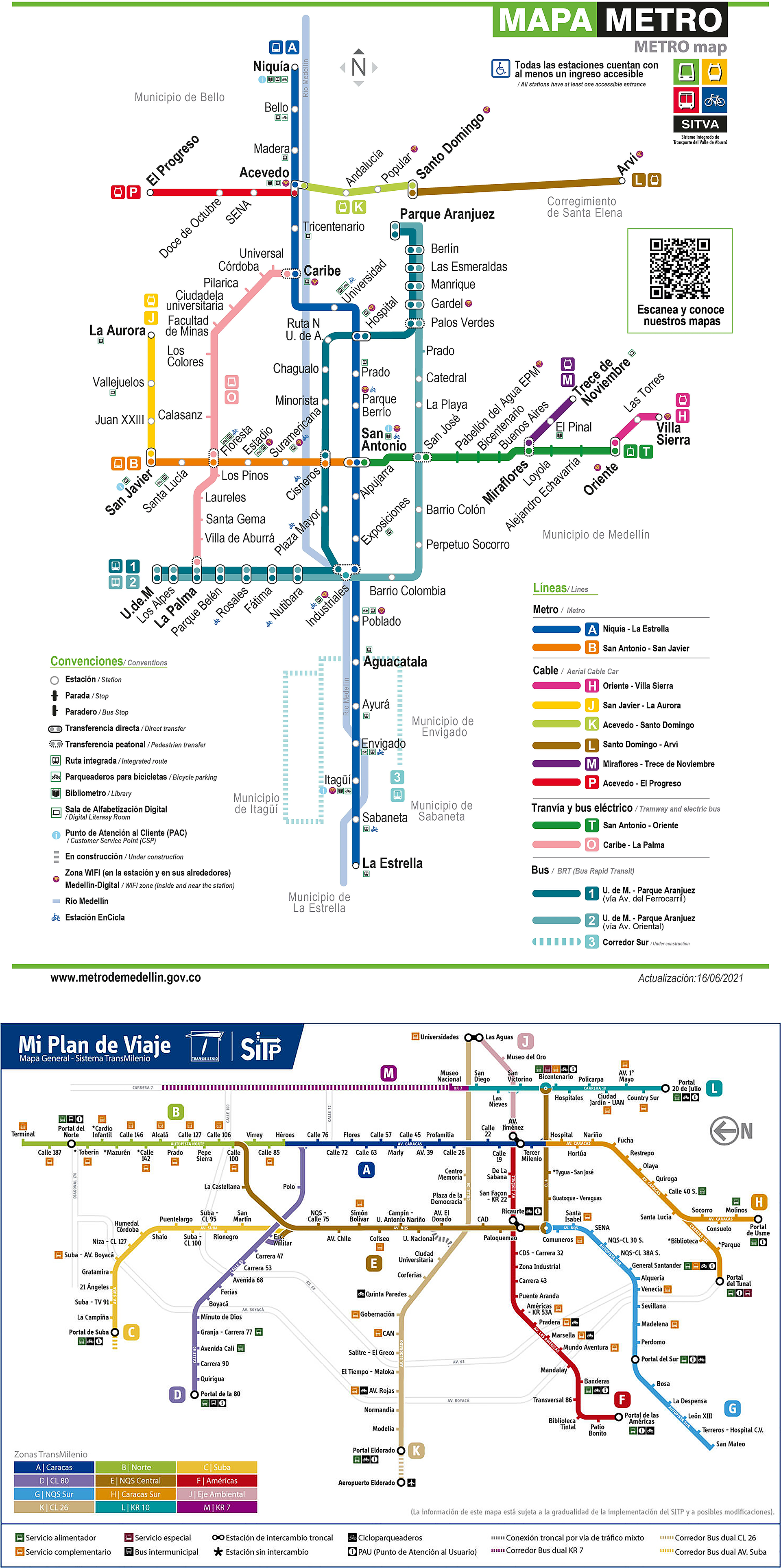
The practices of feminist geography, walkability indexes, and safety audits map streets from a gender perspective (Col-lectiu Punt 6, 2017; SampaPé, 2019). These techniques develop quantitative and qualitative variables to measure, explore, and analyze the infrastructure and services that cities offer to women. They include social cartography and specific indicators referring to security—against gender-based violence (GBV), among others—, physical accessibility—for people with disabilities but also for exercising care work—, lighting, visibility, cleanliness, among others. These cannot be understood and transformed from a “God’s eye” map (Figure 2) because they are grounded characteristics; they can only be experienced at the street level (Figure 3).
Experts’ Maps: Medellín Metro Map and Bogota’s mass transit system map. Left panel: Medellín Metro (2021) Schematic map, available at: https://www.metrodemedellin.gov.co/viaje-con-nosotros/mapas. Right panel: Map of the Integrated Public Transport System, Bogotá (n.d.) available at: https://sitp-bogota.com/mapa-de-transmilenio/. © gov.co. All rights reserved.
Domestic workers’ maps in Medellín and Bogotá. Left panel: Invisible Commutes (2017–2018), Map 21: Medellín (Cleopatra*) Right panel: Invisible Commutes, Map 5: Bogotá (Bolena*), available at: https://www.invisiblecommutes.com/mapas. © Invisible Commutes. All rights reserved.

Experts usually create maps since maps require particular data analysis, drawing, and reading skills to understand the landscapes’ phenomenological and atmospheric qualities (Desimini, Reference Desimini, Coomans, Cattoor and De Jonge2019:19). Their elevation not only refers to the perspective from which experts draw the map but also to the elevated role in the expertise’s hierarchies (Certeau, Reference Certeau1984; Ferdinand, Reference Ferdinand, Dibazar and Naeff2018). Expert urban planners and cartographers often answer to those holding political and economic power (Certeau, Reference Certeau1984; Ferdinand, Reference Ferdinand, Dibazar and Naeff2018). These experts generally follow standard mapping procedures, focusing on specific objects rather than the relationship among them, and mostly assume linear time (Cattoor, Reference Cattoor, Coomans, Cattoor and De Jonge2019:64).
Expert mapping procedures and experts themselves present several problems. First, standard processes constantly limit the designer’s ability to engage with these spaces’ contradictions and competing demands (Cattoor, Reference Cattoor, Coomans, Cattoor and De Jonge2019:64). Diverse individuals who inhabit and cross spaces raise diverse social, cultural, environmental, and economic demands. Second, map production based primarily on quantitative data has led to a departure from scale, material, and temporal and substantiated aspects, leading to losing temporal and spatial precision on the human scale (Desimini, Reference Desimini, Coomans, Cattoor and De Jonge2019:18). Although maps are supposed to lose temporal and spatial precision, in this study, this is not a feature but a bug. By lacking this precision, maps miss subjective and dynamic experiences, materiality, and grounded approaches to real life in a set space and time that could help people efficiently interact with the tools they provide.
Third, often those who have the power and technical skills to map are unaware of the injustices that the map should reflect, thus reproducing and reinforcing these inequalities (Elwood and Leszczynski, Reference Elwood and Leszczynski2013; Leszczynski, Reference Leszczynski2015; Ricker et al., Reference Ricker, Kraak, Engelhardt, Engebretsen and Kennedy2020:411). Likewise, while cartographers seize the space from above, exercising a dominant position, subjects who cross the streets experience the space creatively “from below” from a subordinated stance (Ferdinand, Reference Ferdinand, Dibazar and Naeff2018:145). Experts and their maps depart from alternative views of geography that they consider deviations from conventional techniques (Ferdinand, Reference Ferdinand, Dibazar and Naeff2018:146). Finally, a deficient understanding of these maps, especially city and transportation systems’ cartographic representations, limits blood-and-flesh humans’ access to RtC. It is particularly burdensome for users experiencing intersecting sources of inequality, such as domestic workers.
The city is the meeting place, the spatial environment to develop the capacities and exercise (or not) human rights (Correa Montoya, Reference Correa Montoya2011). Through his RtC concept, Henri Lefebvre centered on the individual and his claims (Lefebvre, Reference Lefebvre1968). From Brazil, Edesio Fernandes has delved into the concrete legal implications of this right, focusing mainly on urbanization from the perspective of property and housing rights (Fernandes, Reference Fernandes2007).
The World Charter of the Right to the City defines RtC as a collective right of urban dwellers, especially the most vulnerable groups, to use and obtain the equitable fruits of cities within the framework of sustainability, democracy, equity, and social justice (Carta Mundial Por El Derecho a La Ciudad, 2004). This right must be based on uses and customs to exercise the right to free self-determination and an adequate standard of living. It is interdependent with civil, political, economic, social, and environmental rights in international human rights treaties. Article 13 states that cities should guarantee mobility for all, following an urban and interurban circulation plan and through accessible, affordable, and sustainable public transportation systems.
Two key concepts are worth highlighting. First, the accessibility framework refers to the opportunities (e.g., health care, employment, or education) available (or their variations) for a person or a group through the mobility system (Baltimore EJT Project and Transportation Equity Cooperative Research Program, 2011). Mobility issues, information, signage, affordability, connectivity, and land use patterns all affect accessibility (Litman, Reference Litman2022).
Limited accessibility negatively affects users’ livelihoods, producing social exclusion, especially for particular social groups such as children, women, low-income people, and people with disabilities (Montes Calero et al., Reference Montes Calero, Montoya-Robledo, Noboa Lopez, Scholl, Sandoval, Lee, Rodriguez Porcel, Scholl, Fook and Barahona2022). Studies on intersectional vulnerability and transportation reflect the specific commuting patterns and experiences of vulnerable social groups moving around particular urban areas. For example, in Latin America, low-income populations living on the cities’ periphery are captive users of public transit since they lack the resources to afford costlier alternatives (Jirón, Reference Jirón2011; Montoya-Robledo and Escovar-Álvarez, Reference Montoya-Robledo and Escovar-Álvarez2020; Moscoso et al., Reference Moscoso, López, Montoya, Quiñones, Gómez, Lleras, Adriazola-Steil and Vega2020). Likewise, studies of low-income urban dwellers in Mumbai found that low-paid workers, especially informal workers, often walk more and use more public transportation than their higher-income counterparts (Baker et al., Reference Baker, Basu, Crooper, Lall and Takeuchi2005).
Women, who are heterogeneous, suffer from limited accessibility, especially as the majority of users in Latin-American public transit (Granada et al., Reference Granada, Urban, Monje Silva, Ortiz, Pérez, Montes and Caldo2016). Limited accessibility comes from having commutes that transportation planning ignores, such as the mobility of care and the mobility for paid care (Sánchez de Madariaga, Reference Sánchez de Madariaga, de madariaga and Roberts2013; Montoya-Robledo et al., Reference Montoya-Robledo, Montes Calero, Bernal Carvajal, Galarza Molina, Pipicano, Peña, Pipicano, López Valderrama, Fernández, Porras, Arias and Miranda2020; Montoya-Robledo and Escovar-Álvarez, Reference Montoya-Robledo and Escovar-Álvarez2020), facing constant sexual harassment and other sources of violence such as common and racial violence (Montoya-Robledo, Reference Montoya-Robledo, Peake, Adeniyi-Ogunyankin and Dattan.d.-b; Montoya-Robledo, Reference Montoya-Robledon.d.-c; Kash, Reference Kash2019; Soto Villagrán, Reference Soto Villagrán2019; Quiñones, Reference Quiñones2020; del Mar Rodas-Zuleta et al., Reference del Mar Rodas-Zuleta, Cardona and Escobar2022), being the majority of immobile people (Riera, Reference Riera2018), and spending large percentages of their income in public transportation (Montoya-Robledo, Reference Montoya-Robledo, Coggin and Madhavn.d.-a; Montes Calero et al., Reference Montes Calero, Montoya-Robledo, Noboa Lopez, Scholl, Sandoval, Lee, Rodriguez Porcel, Scholl, Fook and Barahona2022).
Domestic workers are a vast group of women experiencing inaccessible transport in Latin America. As highly feminized occupation, female domestic work represents 91% of the 14 million domestic workers in the region (International Labour Organization, 2021). Recent studies have shown that they experience the longest commutes of all occupations in cities like Bogotá, Colombia (Fleischer and Marin, Reference Fleischer and Marin2019; Montoya-Robledo and Escovar-Álvarez, Reference Montoya-Robledo and Escovar-Álvarez2020). According to qualitative data collected by the Invisible Commutes transmedia project, their commutes can climb to seven hours round-trip in Bogotá, six hours in Lima, five hours in Sao Paulo, and four hours in Medellín (Montoya-Robledo et al., Reference Montoya-Robledo, Goméz-Restrepo and Gonzalez-Robledo2022a). Transportation planners dismiss care work as work and disjoin their working sites in residential areas to vast mobility systems (Buchely and Castro, Reference Buchely and Castro2016; Montoya-Robledo (Reference Montoya-Robledo, Peake, Adeniyi-Ogunyankin and Dattan.d.-b)). In these long commutes, these women spend large percentages of their limited income on transportation and experience health hazards due to the high quantities of particulate matter they inhale (Montoya-Robledo and Escovar-Álvarez, Reference Montoya-Robledo and Escovar-Álvarez2020; Montoya-Robledo et al., Reference Montoya-Robledo, López Valderrama and Iguavita2022b).
Inaccessible transportation for domestic workers and other similarly situated commuters connects to their specific understanding of the city they inhabit. Proper information in maps and signage can make their commutes manageable. Feminist geography can improve their access to the city via proper cartographic and signage devices.
Feminist geography is an epistemological and activist field of research methodologies (England, Reference England, Aitken and Valentine2006). It studies, among others, the ideological argument that places women in the private sphere and men in the public sphere (Scott, Reference Scott1988; Rose, Reference Rose1993; Okin, Reference Okin1998). Historically, some geographers and planners have viewed the city as a predominantly male space, leading to maps and analyses that primarily cater to men’s realities, disregarding women’s experiences and practices (Townsend, Reference Townsend1991; Rose, Reference Rose1993; Kern, Reference Kern2019).
Precisely, feminist geography criticizes cartography and the use of GIS because they adopt an external perspective, from the all-powerful “God’s eye” claiming to see everything from nowhere, although experiences and realities are situated (Haraway, Reference Haraway1991; Kwan, Reference Kwan2002). Kwan believes that feminist geographers must develop strategies to make a GIS-based physical map responsive to feminist discourse (Kwan, Reference Kwan2002). Accordingly, one must analyze what has been excluded from the data and the maps (Moore, Reference Moore2018) to understand whose experiences remain hidden and how including them could help ensure their RtC.
1.2. Methodology
Fieldwork was conducted between May 2017 and August 2018 in Bogotá and Medellín (Montoya-Robledo, Reference Montoya-Robledo2020). The Harvard Ethics Committee approved a semi-structured questionnaire, including questions about how the transportation system worked, who it was planned for, what were its shortcomings, and some particular experiences in terms of time, money, and service. Following a snowball methodology, domestic workers, transportation experts, local and national government officials, domestic workers, and employers were contacted via email and WhatsApp. The interviewee chose the place for the interview according to her comfort. Domestic workers responded during their free time, at home, or in public sites. I interviewed employers at home, while experts and public officials responded to the interview in their houses or offices during their workday.
We read together an informed consent form. Domestic workers and employers kept their personal information anonymous, while experts and public officials could remain anonymous or include their full names. Domestic workers could do the interview and the map and decide whether I could accompany them on a full-day commute, where I conducted an observation. Through social cartography, domestic workers drew their commuting route in the public transport on white pieces of paper, which can be consulted in the “mapas” tab on the Invisible Commutes website,Footnote 1 and also in Zenodo.Footnote 2 I excluded the first set of maps with the shape of the cities because they could not situate themselves in them. Two maps, one from Bogotá and one from Medellín, were randomly chosen for this study’s analysis. Approximately 40 domestic workers, 20 employers, and 120 public officials and experts were interviewed in both cities until a saturation point was attained.
Qualitative data were analyzed by Atlas.ti software. Based on the interviews, participant observations, and maps, categories around topics repeated among interviews, including lengthy commutes, expenses, sexual harassment, racism, other sources of violence, transportation means, signage, educational level, and poverty level, were created and defined. Information was classified, and then findings were analyzed through a local government law perspective, a gender lens, an intersectionality lens, and finally, a cartographic approach.
One map from Medellín’s Metro from 2021 and one from Bogotá’s Transmilenio system (no date) were also collected from the official websites. They were analyzed based on (1) the names of the stops vis-à-vis essential landmarks in both cities; (2) geographical accidents; (3) cardinal points; (4) inclusion-related information such as accessibility for people with disabilities; (5) conventions; and (6) missing information found in qualitative data such as the location of dangerous places in terms of GBV.
2. Findings
2.1. Experts’ maps and signs of mobility systems
The integrated transport system of Bogotá (SITP) and the integrated transport system of Valle de Aburrá (SITVA) are mass means of transport, articulated and integrated in terms of infrastructure, fares, and services. University-educated urban planners, designers, architects, and engineers, the vast majority of whom are men, designed and built these systems. National and local legal regulations govern their construction and operation. Their underlying idea is to modernize public transport, which has a specific historical background linked to international modernization ideas (Ardila, Reference Ardila2003; Metro de Medellín, 1998; Salazar Pineda, Reference Salazar Pineda1987). Control over cartography is crucial in creating the image of orderly, modern cities, attractive for tourism and investment (Eslava, Reference Eslava2012). According to Eslava, compared to other official maps of Bogotá, these show cities from their best angle: harmonious, organized, sustainable, and developed in an egalitarian way, beyond daily contradictions and inequalities (Eslava, Reference Eslava2012).
The integrated transport systems and the maps that represent them follow a rationalization and objectivity logic. One expert said, “We must articulate [the transportation system]. It is like a nervous system or a circulatory system. It is a way of having […] systems in a hierarchical logic, hierarchical corridors, and how I bring the big flows. We began to collect the flows through the capillaries, and I have to consider where to take them and through what paths” (Pizarro, 2018). These maps show these hierarchies, with smaller lines feeding broad, massive trunk lines to group users. These maps are located at stations and stops of both systems, and their recipients are the users.
Both maps use specific letters and differentiated colors indicating the lines of public transport (they exclude the integrated routes of zonal buses). They have signs for each station. The metro system map includes specific conventions referring to stations, stops, Wi-Fi zones, accessible places for people with disabilities, and modal connections. The Transmilenio map in Bogota features other conventions, such as bicycle parking and interchange stations. Both point to the north of the city through cardinal symbols.
The names given to the stops refer to specific urban vital points. For example, in Medellín, some stations have the municipality’s name, such as Itagüí, Sabaneta, or La Estrella. However, it is unclear from the map that the Envigado station lies beyond the municipality’s jurisdiction with the same name due to political struggles (Montoya-Robledo, Reference Montoya-Robledo2020). In Bogotá, references to the street name or emblematic sites such as Virrey Park, the Aguas sector, or the El Dorado portal close to El Dorado international airport provide referential guidelines. However, other stops remain obscure to users learning to navigate and understand the city from below. Despite these attempts to make them legible, the maps do not account, for instance, for the dangerous areas with the highest occurrence of GBV or the care-related sites; they hide the geography of the cities that are crucial landmarks, such as Cerro de Nutibara in Medellín or the Cerro de Monserrate in Bogotá, they lack references to crucial businesses, churches, stores, or meeting places.
Other distinctive symbols help users understand and use public transportation systems. In Bogotá, the SITP also includes zonal buses outside the exclusive trunks of Transmilenio’s Bus Rapid Transit (BRT). Zonal buses replaced traditional collective bus routes and operate in city streets, sharing lanes with other vehicles. Conventional buses had boards on the right side of the front window with names of the areas through which their routes operated. Heyner, a person who created these boards, recounts that “[t]o make a board, I would get on the bus […] to take the tour. I observed the key points for people to locate themselves. Then I went back to the workshop and started designing” (Puentes, Reference Puentes2018). Traditional buses are related to the users at the street level, responding to urban references from below. Nevertheless, these buses did not respond to transport rationalization and city modernization that experts longed for.
With the creation of the SITP (Decree 309 of 2009), Bogota’s mayor sought to consolidate an integrated system including the BRT, feeder buses and zonal buses, and the transmicable. Modern buses with greater passenger capacity replaced conventional buses. Between 2010 and 2015, the latter went from 16,000 to 5000 (García, Reference García2018). Digital boards replaced the graphics or the geographical references that users traditionally used to recognize routes. The district government contracted with a signage company that eliminated traditional boards (García, Reference García2018). People were lost when the signs for the new SITP zone buses changed (García, Reference García2018). Users say State pedagogy was absent, but the former Mobility Secretary argues that the Transmilenio company and the Secretariat carried out copious campaigns and “Plan Padrino,” through which technicians taught users about the changes (García, Reference García2018).
2.2. Domestic workers’ maps and how they learned to understand the city
Experts who created the SITVA of Medellín and the SITP of Bogotá hold a professional education and desire to modernize and rationalize the system. This standpoint translates into transit maps and signage. Opposingly, domestic workers experience mobility differently, as revealed in their commuting maps and testimonies. Their lack of education, the change from a rural to an urban world, and the referential teaching they got from their social networks distance from the expert’s view who plans transport and draws it through his aerial maps. This explanation responds to the feminist methodologies of qualitative research that seek to understand better the why and how of these visions and graphic representations.
Domestic workers have deficient educational levels. In Colombia, for 2016, the Broad Home Survey (GEIH for its name in Spanish) showed that 4.9% of domestic workers had no educational level, 38.6% had finished elementary school, 26.9% had completed middle school, 22.5% had completed high school (Osorio Pérez, Reference Osorio Pérez2018). These low alphabetization levels mirror domestic workers’ testimonies and increase the gap between the expert knowledge reflected on the maps and these women’s vision of cities. For example, Amparo* recounts, “The only chance I had to earn a living was to be a domestic worker because I had no studies. I did not go to school. My uncle taught me to read and write. I dropped out of school because, once my dad went fishing. He left me to care for his donkey, but I went to school instead. The donkey flew away, so my dad told me that if I returned to school, I would be in real trouble” (Amparo*, 2017). Amparo’s* story denotes her lack of educational opportunities, the punishment for not having complied with a typical rural obligation such as caring for animals, and domestic work as the only avenue for survival. However, it also shows her rural origin opposing urban realities she later encountered through domestic work in Medellín.
Likewise, workers like Elisa*, Libertad*, and Rosa* also describe their arrival in Medellín from Chocó and Urabá, Antioquia, and their limited educational opportunities. Rosa explains, “I dropped out of school because I had to work when I was little […] extracting gold with my mother…the study was not a priority for them at that time…” (Rosa*, 2017). Rosa’s* story, like Amparo’s*, demonstrates restricted access to education and a profoundly rural context. In her case, the river and mining, alien to Medellín, were essential to her economic sustenance.
Cleopatra*, originally from Tutunendo, Chocó recounts,
“I never set foot on campus. When I arrived in Medellín, I had never been to school. Because I was a woman and the eldest, I had no right to go to school. […] I learned to read on television through a TeleAntioquia program at 13. […] I would tear the pages out of the notebooks of the children I cared for to study” (Cleopatra*, 2017).
Cleopatra’s* story reveals gender stereotypes that limit girls and women’s education and her will to become literate with the minimum resources available.
Clara* started studying later on in life because initially, the school was far from her home. Because of her age, most of the students made fun of her. Thus, she dropped out of school and learned to read independently (Clara*, 2018). Once again, the story narrates the connectivity difficulties to an educational site and the consequences on her literacy level.
All domestic workers interviewed came from small municipalities and the countryside to large cities such as Bogotá and Medellín. These peasant women were not accustomed to traffic. They also highlighted the long distances traveled from their towns of origin to the cities where they started to work. Clara* had to get on a bus for more than eight hours to get to Bogotá (Clara*, 2018). On the trip from San Jerónimo to Medellín, Esperanza* could not stop vomiting because she had never ridden a car (Esperanza*, 2017). Still a child, Rosa* traveled from Istmina, Chocó to Medellín. Her encounter with the new city initially dazzled her:
“My mom sent me to my sister to find a job. When I arrived in Medellín, I saw it as something different […]. There were many lights. I felt like I was in paradise…those landscapes. I arrived around four in the morning, and the streets were very lonely.” (Rosa*, 2017).
Contrary to Rosa*, Bolena* was 19 when she arrived in Bogotá from Neira, Caldas. She feared the overcrowding and the loud noises: “In the terminal, they began to give me sweets. […] They welcomed me to Bogotá. Then they asked me for the money and made fun of me” (Bolena*, 2018). For Yolima*, arriving in Bogotá was terrible, not only because she felt lost when she landed at a pension downtown but also because she was forcibly displaced in 2006 from Chocó (Yolima*, 2018). This multiplicity of arrival experiences unveils fear, illusion, adventure, loss, the violence of the armed conflict, and the terror and hope of changing their lives from inhabiting the countryside to living in large urban areas.
The rationality of the big city challenged domestic workers. Many like Milvia* and Linda* began working as in-house domestic workers, taking longer to learn how to move around the city (Linda*, 2018; Milvia*, 2018). Once, Rosa* left her employer’s house because she was bored. Walking down the street, she asked where the Santa Cruz neighborhood was. People told her she was lost. Rosa* narrates, “I returned to [my employer’s] house, and she scolded me because I left the door open. On Sunday, my sister went to pick me up and explained how to go alone to Parque Berrío, Nutibara, Parque Bolívar, to Santa Cruz…” (Rosa*, 2017).
Reinalda ignored the bus routes, initially spending her salary on taxis. Later, her friend taught her how to use collective public transport and to recognize Medellín’s reference points (Montoya-Robledo and Goméz-Restrepo, Reference Montoya-Robledo and Goméz-Restrepo2019). Lucía’s brother told her how to commute in Bogotá (Lucia*, 2018). Years after arriving in Medellín, Esperanza* still uses traditional buses because that was how they initially taught her to commute (Esperanza*, 2017). She fears the mass metro system, which remains unintelligible.
Being amazed or afraid of this unknown world, understanding the city, facing it, and recognizing the reference points, starting from a collective learning process far from expert knowledge. A friend or relative introduced them to this urban literacy through street direct observation. For domestic workers, the city differs from this rational world that experts promote to make it attractive to investment and international tourism. It is a site they traverse daily to earn a living, and they evaluate strategies to do so as safely as possible. Their low schooling levels, the contrast between their place of origin in rural areas or peripheral municipalities and the big city, and learning to move through street references appear in their maps. Two examples are presented as follows:
Cleopatra’s* map (Figure 3: left) shows the critical landmarks of her journey: her house, the Torres de Bomboná (Tore von vona) in the center of Medellín, the Oriental (western) avenue where she makes the change bus, the San Diego Shopping Center (SanDiego), and El Poblado neighborhood (Povlao) where she works. The spelling of the places is phonetic, which reflects her low level of education.
Bolena’s* map (Figure 3: right) shows several of her commuting routes. She works in the north, so there she locates several Transmilenio stations. Since her family inhabits Cazuca and San Joaquín neighborhoods, she also shows these routes in which she refers to Boyacá Avenue, San Joaquín, Meisen Hospital, and Cazuca. The eastern Cerros, essential for those who navigate the city, appear at the top of the map, with the cross of the Cerro de Monserrate behind.
Both maps lack the cardinal symbols that are essential in expert maps. They are referential maps drawn from the street level, depicting the city’s appearance when you travel with your body. They are not maps based on quantitative data but on Bolena* and Cleopatra*‘s subjective experiences; maps reflect their educational level, their way of seeing and understanding the city, and how they learned to move around it. On these maps, the landmarks are those references to get to work, which is their means of survival. That rational and modern city, created by experts to attract international attention, is absent, as well as the museums, the botanical gardens, the central squares, and the tourist icons in the mass transit maps above. It may even account for the fact that these are not places that domestic workers usually visit and that makes us question their RtC.
2.3. The gap between experts’ and domestic workers’ maps and RtC
In the context of RtC, transportation is both a right and a derivative demand. Transport connects people with opportunities and services, ensuring the rights interrelated with RtC. For example, you must move toward the square where a political march occurs to exercise your right to political participation. Hence, if you ignore how transport works or what services and opportunities it connects because the map is illegible according to your educational level, or urban literacy, you cannot exercise quality mobility or other rights part of RtC.
Domestic workers’ maps analyzed here and others found in the Invisible Commutes website lack the squares, museums, recreation, or leisure centers reflected in “expert” maps. The key elements were homes and job sites, and in Bolena’s case*, relatives’ homes. Two issues are worth examining: First, since these were the routes they learned, their limited access to education, and their own experiences, the other urban opportunities and services still need to be included. Second, since the public sphere has been mainly a masculine space, domestic workers remain circumscribed to the private sphere at home and in their paid work on the domestic site. For them, the city is almost an accident in their survival (Montoya, Reference Montoya2019). Although the city offers varied services, the gap between the experts’ and domestic workers’ notions of the city is so big, and the ideology of the public as masculine is so ingrained that they have no way of accessing urban fruits equitably in a sustainable, democratic, or just manner, as RtC prescribes. Likewise, as long as the vision of domestic workers about the city and mobility remains absent from the transportation system’s maps, this gap will remain.
3. Lessons Learnt
Thinking of RtC regarding access to other rights through the effective connection with opportunities and services through transport necessarily involves systems mapped legibly for all.
Here are some concrete public policy recommendations to bridge the mapping gap:
-
- Before looking at the quantitative data, the cartographer working at Transmilenio or the Metro company should consider what is the purpose of the map, what is the story it wants to tell, who are the target or potential users, how to involve them in the entire map designing process, in what environment will the map be used, and in what mode (Ricker et al., Reference Ricker, Kraak, Engelhardt, Engebretsen and Kennedy2020:412).
-
- Cartographers and transportation planners should promote the effective participation of underrepresented and vulnerable urban subjects such as children, people with disabilities, migrants, elders, and domestic workers. It entails finding and contacting them; bringing their voices and maps to the table around critical topics related to RtC, transport accessibility, affordability, and sustainability; their way of understanding and experiencing the city; paying for their transportation expenditures; and providing care for their dependents when necessary.
-
- Cartographers and transportation planners should map new projects in a participatory way and remap already-made maps. It would be essential, for instance, in the Corredor Verde of Carrera Séptima and the metro in Bogotá, the light metro of la ochenta in Medellín, and Line 2 of the metro of Lima. Nevertheless, already-“finished” maps should also be reconsidered (Cattoor, Reference Cattoor, Coomans, Cattoor and De Jonge2019). Maps should include the expert techniques and the knowledge inscribed in the bodies of these women who traverse the cities daily. This remapping could take place in the Metros of Santiago, Mexico City, Buenos Aires, Sao Paulo, Rio de Janeiro, and BRT systems such as the MIO in Cali, Transmilenio in Bogotá, and the BRT line in San Salvador. Consultations at various stages of the process on signage, effective communication, and cartography with captive public transit users, such as domestic workers, are essential to avoid potential confusion from introducing a new mass transit map in a city.
-
- Cartographers and transportation planners should combine “God’s eye” mapping formats based on quantitative data with street-level mapping that includes subjective bodily experiences of the challenges domestic workers and other similarly situated commuters face when traversing cities. Combined, both maps could show aerial views of a specific site, with on-the-ground pictures of particularly relevant landmarks, and signal more and less violent areas to make people aware of their surroundings. They should use clear language and understandable images regardless of the educational level of the user.
Implementing these recommendations may expand spatial imagination and dismantle systematized and standardized mapping procedures reflecting the 19th- and 20th-century spatial ideologies (Brenner and Schmid, Reference Brenner, Schmid, Ren and Keil2011). Combining both types of maps can collapse the binary, including the people who inhabit it and the phenomena and practices that occur on the ground (Ferdinand, Reference Ferdinand, Dibazar and Naeff2018:146 and 156). It can break the domination of “men” experts from above, bringing the visions of those experiencing the city with their bodies, and promote RtC truly incorporating equity and social justice.
Acknowledgments
The author is grateful for the participation of domestic workers who are and are not members of UTRASD, experts, and policymakers.
Funding statement
This research was supported by grants from the Harvard Kennedy School, Fellowship from the John R. Meyer Transportation Policy Fund, Harvard Law School, Cravath International Summer Travel Grant, Harvard David Rockefeller Center for Latin American Studies, Summer Research Travel Grant, and Winter Research Travel Grant. The funders had no role in study design, data collection, analysis, publication decision, or manuscript preparation.
Competing interest
The author declares no competing interests exist.
Author contribution
The author was in charge of the whole research and writing process.
Data availability statement
Data on maps of domestic workers are available at: www.invisiblecommutes.com/mapas and DOI: http://10.5281/zenodo.10019083.


 Open access


Comments
No Comments have been published for this article.