


Introduction
The subarctic boreal landscapes of the Siberian taiga may seem remote, but it is here, 8000 years ago, that hunter-gatherers built fortified settlements, many centuries before comparable enclosures first appeared in Europe (Figure 1). The building of fortifications by forager groups has been observed sporadically elsewhere around the world in various—mainly coastal—regions from later prehistory onwards, but the very early onset of this phenomenon in inland western Siberia is unparalleled. This phenomenon, largely unknown to international researchers, can contribute to the critical re-appraisal of narratives of linear pathways to social change increasingly explored in both scientific and popular debates (e.g. Dan-Cohen Reference Dan-Cohen2020; Graeber & Wengrow Reference Graeber and Wengrow2021).
Regions with enclosed/fortified sites of hunter-gatherers and farmers (hatched) and early pottery traditions (green and orange shades) in north-west Eurasia, seventh to sixth millennium cal BC (illustration by B. Ahrens & S. Juncker; pottery distribution modified after Jordan et al. Reference Jordan, K., P., H. Piezonka, F. and J.2016; enclosures of agricultural communities after Müller 2010; see OSM for references).

Pit-house settlements with enclosures consisting of banks, ditches and/or palisades appear on promontories and other topographical peaks across the West Siberian Plain from the end of the seventh millennium cal BC onwards (Borzunov Reference Borzunov2020; Dubovtseva et al. Reference Dubovtseva, Kosinskaya, Piezonka and Chairkina2020; Schreiber et al. Reference Schreiber, Piezonka, Chairkina, Dubovtseva, Kosinskaya, Ibsen, Ilves, Maixner, Messal and Schneeweiß2022; see online supplementary material (OSM)). These complex settlements are part of a broader set of socio-economic and technological innovations and transformations in western Siberia and thus demarcate a phase of accelerated social change that is only partially understood. Here, we present new results from the key site of Amnya, part of our ongoing systematic programme of research (Dubovtseva et al. Reference Dubovtseva, Kosinskaya, Piezonka and Chairkina2020; Chairkina & Piezonka Reference Chairkina and Piezonka2021; Schreiber et al. Reference Schreiber, Piezonka, Chairkina, Dubovtseva, Kosinskaya, Ibsen, Ilves, Maixner, Messal and Schneeweiß2022). By contextualising new chronological data and structural evidence of the architectural features and layout of this complex, we put forward various scenarios that might explain the sudden and unprecedented emergence of diversified hunter-gatherer life worlds in the west Siberian taiga 8000 years ago.
Territoriality, social diversification and fortification in hunter-gatherer societies
In western archaeological narratives, explicitly or implicitly rooted in evolutionist thinking, the transition to farming is often regarded as fundamental to socio-political, economic and ideological ‘complexity’ (Arnold et al. Reference Arnold, Sunell, Nigra, Bishop, Jones and Bongers2016). Archaeological definitions of social complexity vary greatly, as the key criteria used to define what qualifies as ‘complex’ are inconsistent across the discipline. Diverse combinations of traits such as sedentism, high population densities, surplus economies, emerging social hierarchies and hereditary leadership, warfare and the construction of fortifications are typically associated with the concept of social complexity (Dan-Cohen Reference Dan-Cohen2020). In this article, we deliberately avoid the term ‘(social) complexity’ as it evokes an evolutionistic notion of change in human societies and, instead, we approach the observed societal dynamics as ‘diversification’. By diversification, we refer to the societal background of increased heterogeneity, as expressed through new material practices such as pottery production and monumentality at the end of the seventh millennium BC.
Research on defensive architecture has traditionally fallen within the remit of studies of agricultural, pre-state and state societies (e.g. Ballmer et al. Reference Ballmer, Fernández-Götz and Mielke2018). Accounts of defensive behaviour in non-farming societies are comparatively rare, and the topic remains largely absent from recent handbooks on hunter-gatherers and on conflict archaeology (e.g. Cummings et al. Reference Cummings, Jordan and Zvelebil2014; Fernández-Götz & Roymans Reference Fernández-Götz and Roymans2018). It is primarily in the Americas that investigations of hunter-gatherer defensive architecture have progressed, increasingly leaving behind (neo-)evolutionist and behaviouralist frameworks and, instead, focusing on political economy, anarchist and post-humanist approaches (e.g. Angelbeck Reference Angelbeck2016; Grier et al. Reference Grier, Angelbeck and McLay2017). Russian-language, principally descriptive-positivistic or ethnohistoric studies on the topic have so far received little international attention (Perevalova Reference Perevalova2002; Borzunov Reference Borzunov2020).
Both archaeological and ethnographic studies document a variety of motives for the building of fortifications, depending not only on the anticipation of threat but also on defensive strategy and social structure (Clark & Bamforth Reference Clark and Bamforth2018). In mobile societies, fortification can be a strategy to pre-empt the unpredictable behaviour of others, such as raiding (Golovnev & Osherenko Reference Golovnev and Osherenko1999). Reliable (seasonal) resource abundance and opportunities for mass harvesting can trigger increased territoriality and ownership among hunter-gatherer groups (e.g. Schulting Reference Schulting and Ralph2013). Permanent sites, for example the formal cemeteries of the Late Mesolithic increasingly recognised across northern Eurasia, have been linked to such territorial claims (Rowley-Conwy Reference Rowley-Conwy, Zvelebil, Dennell and Domanska1998; Schulting et al. Reference Schulting2022). Ostensibly defensive architecture, as the long-term construction of space, can likewise have parallel functions, serving as landmarks in collective memory and identity (Grier et al. Reference Grier, Angelbeck and McLay2017). As manifestations of social inequality, fortifications can also be related to (heritable) property rights, labour obligations and the restriction of access to resources (e.g. Golovnev Reference Golovnev, Schweitzer, Boesele and Hitchcock2000; Grier et al. Reference Grier, Angelbeck and McLay2017). Increasing political differentiation is not necessarily accompanied by greater wealth inequality, however, and defensive architecture can also be coordinated without a centralised authority (Angelbeck Reference Angelbeck2016; Moreau Reference Moreau2020).
Materials and methods
There is a long history of hunter-gatherer fortifications in western Siberia, extending from the Stone Age through to the Russian conquest of the region in the sixteenth and seventeenth centuries AD. Ethnohistoric evidence provides insights into motives and strategies for the construction of these defensive sites (Golovnev & Osherenko Reference Golovnev and Osherenko1999; Schreiber et al. Reference Schreiber, Piezonka, Chairkina, Dubovtseva, Kosinskaya, Ibsen, Ilves, Maixner, Messal and Schneeweiß2022).
The context of ancient fortifications in western Siberia
Western Siberia, between the Ural Mountains and the River Yenisei, represents a particularly rich ecosystem from a hunter-gatherer-fisher perspective. Fish, aquatic birds, forest fowl and large game such as elk and reindeer have predictable seasonal behaviours, and this abundance may have contributed to a rise in population and socio-political differentiation once the mass-harvesting strategies of such ‘naturally stored’ resources developed (Golovnev Reference Golovnev1995; Adaev Reference Adaev2007). Storable and transportable goods made from these natural resources could include fish oil, fish meal, dried/smoked fish, dried birds and frozen meat—goods made and used by Indigenous groups in western Siberia to the present-day (Piezonka Reference Piezonka, Nieuwenhuyse, Bernbeck and Berghuijs2023). These ‘front-loaded resources’, that is, goods that are labour-intensive to acquire and process but which can be stored and are subsequently easy to transport and prepare (Bettinger Reference Bettinger2009), would have been a target for raiders.
Early Holocene pre-pottery hunter-gatherer sites (termed ‘Mesolithic’ in the regional periodisation, see OSM) are concentrated in the Urals region and more sparsely distributed in the low-lying expanses further east. This latter area became occupied more intensively only from the later seventh millennium cal BC (regionally termed ‘Neolithic’ but referred to as the pottery Mesolithic in Western terminology; see Figure S1). Among these pioneering sites are the earliest fortified settlements in northern Eurasia with evidence for hierarchical organisation indicated by pit houses of differing sizes; eight Stone Age examples are currently known (Borzunov Reference Borzunov2020; Figure 1). Another new site type that emerged in this period is the large, stratified mound (Russian kholm), with examples reaching 50m in diameter and up to 6m in height (Panina Reference Panina2011). These mounds are characterised by unusual features such as groups of human skulls, clay figurines, bone and antler, hearths and post-row structures, and are interpreted as ritual or sacrificial sites (Shorin Reference Shorin2017; Piezonka et al. Reference Piezonka2020). The adoption of pottery technology by the local hunter-gatherer communities is another novel feature of this period of change in the seventh millennium BC (Chairkina & Kosinskaia Reference Chairkina, Kosinskaia, Jordan and Zvelebil2009; Piezonka et al. Reference Piezonka2020).
The Amnya archaeological complex
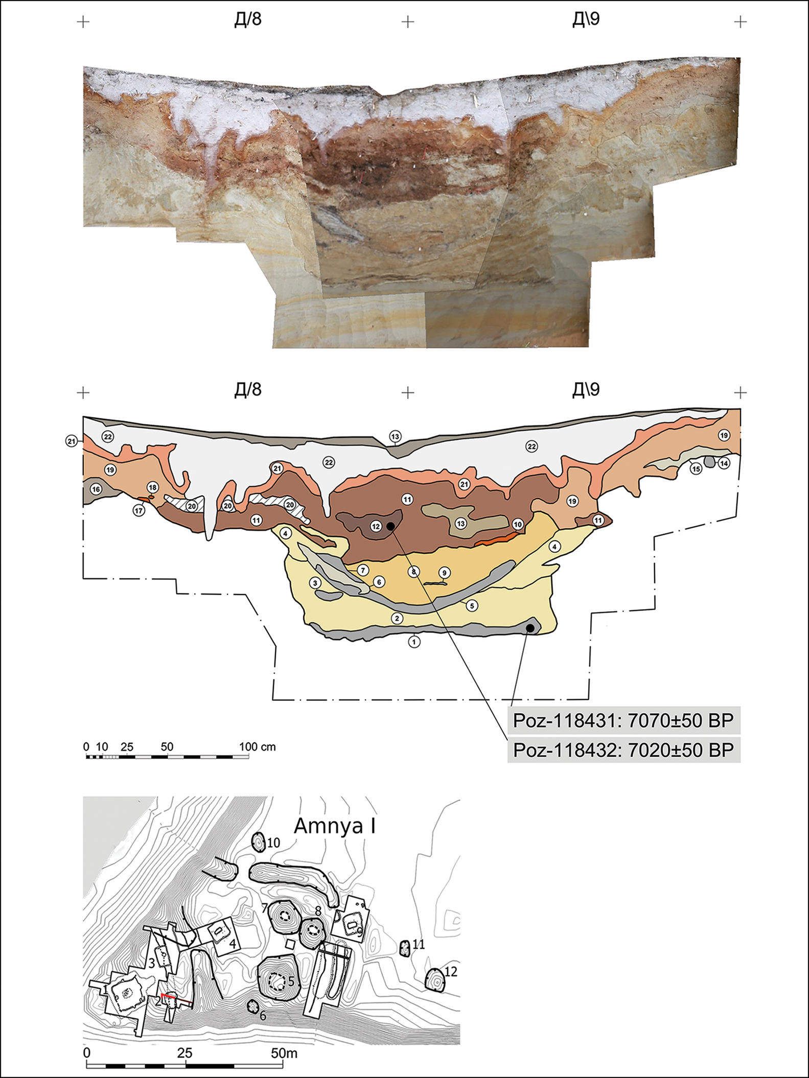
Amnya I is regarded as the northernmost known Stone Age fortification in Eurasia and, based on current evidence, also one of the oldest fortified habitation sites worldwide (Morozov & Stefanov Reference Morozov and Stefanov1993; Dubovtseva et al. Reference Dubovtseva, Kosinskaya and Piezonka2019; Borzunov Reference Borzunov2020). Located in the northern taiga of the Lower Ob’ region, the settlement occupies a sandy spit above a marshy river floodplain (Figure 2). Extant surface features include banks and ditches, which enclose the tip of the promontory, and 10 house pit depressions (Figures 2 & 3). Ten further house pits, located approximately 50m to the east, comprise the open settlement of Amnya II (Stefanov Reference Stefanov and Trufanov2001).
Top: aerial view of the Amnya river and promontory; bottom: general plan of Amnya I and II, showing location of excavation trenches and features visible in the surface relief (illustration by N. Golovanov, S. Krubeck & S. Juncker).

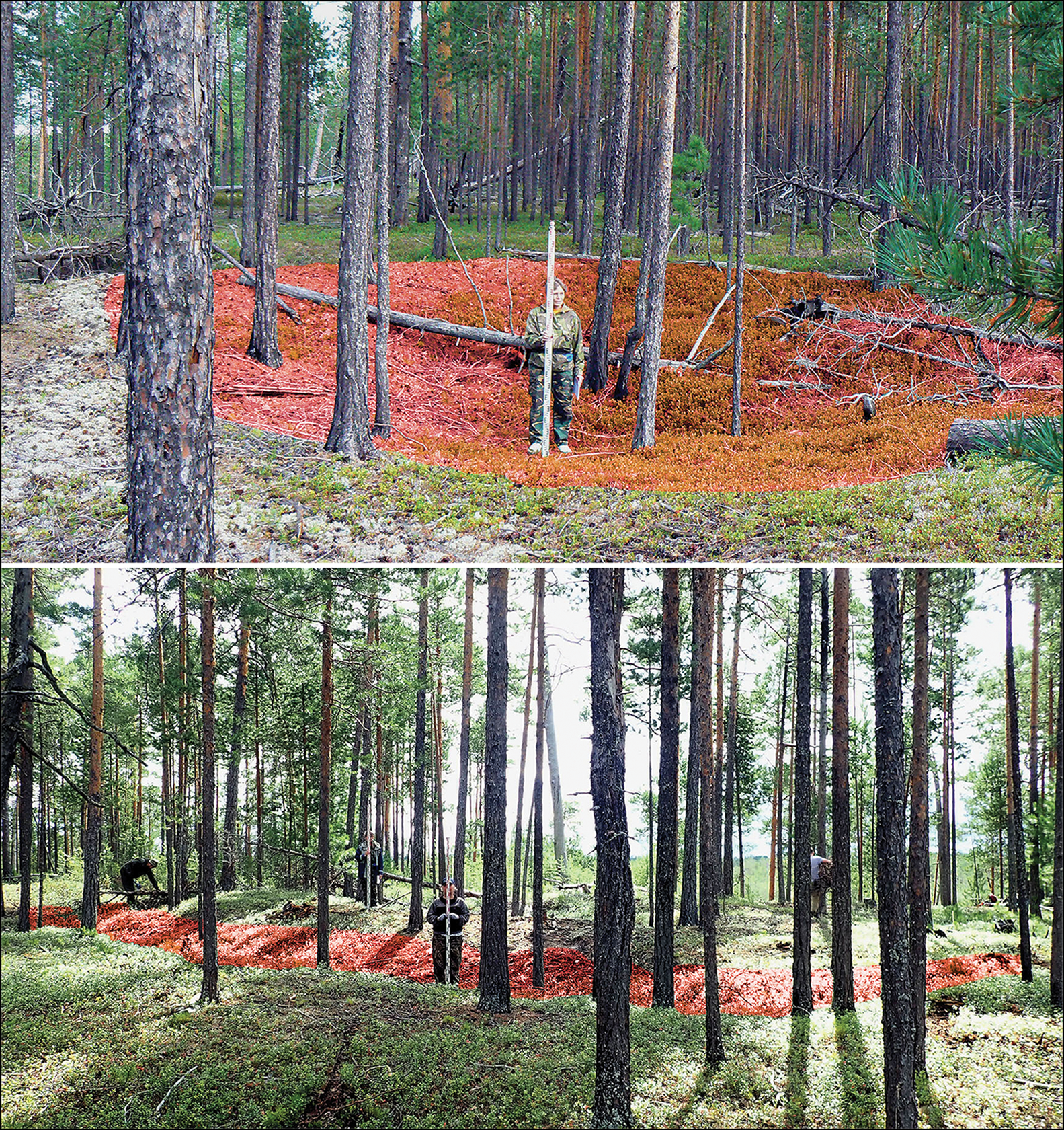
Amnya I, structures in the surface relief (locations highlighted). Top: depression of pit house 5; bottom: outer defence line with bank and ditch III (photographs by E. Dubovtseva).
Excavations at Amnya I between 1987 and 2000 identified wooden palisades, confirming the defensive interpretation of two fortification lines (ditches II and III and associated features). A further, inner ditch across the tip of the promontory (ditch I) was also discovered. The pit houses are rectangular in plan and range from approximately 13 to 41m2 in size, with depths of up to 1.8m. The largest of these pit houses occupies the tip of the promontory (Figures 3, S2 & S3). Construction features, including the presence of central elevated fireplaces, have led to the interpretation of these structures as long-term dwellings (Stefanov Reference Stefanov and Trufanov2001). Stratigraphic evidence from the house pits points to the repeated destruction of the settlement by fire, a phenomenon also observed at other early enclosed sites in the region (Borzunov Reference Borzunov2020: 355–6) and thought to be connected to violent conflict.
The remains of approximately 45 pottery vessels have been recovered from the Amnya complex. Both pointed and flat-based forms are represented, reflecting two distinct typological traditions: one, potentially slightly older, type is broadly characterised by pricked/incised ornament, and the other by comb stamp decoration (Dubovtseva et al. Reference Dubovtseva, Kosinskaya, Piezonka and Chairkina2020; Figure 4, no. 1–5). On some of the house floors, both types of pottery were found together, indicating at least partial contemporaneity (Dubovtseva et al. Reference Dubovtseva, Kosinskaya and Piezonka2019, see also below). Both pottery types belong to the initial phase of the early expansion of ceramic use along the riverine corridors of western Siberia (Piezonka et al. Reference Piezonka2020). The lithic inventory largely consists of quartz but also includes flint artefacts such as microblades and ground slate tools and weapons, including among them numerous slate projectile heads (Figure 4, no. 6–10) (Dubovtseva et al. Reference Dubovtseva, Kosinskaya and Piezonka2019). Bone fragments were preserved only in a calcined state, among which elk, reindeer and beaver have been identified (Morozov & Stefanov Reference Morozov and Stefanov1993).
Amnya I: pottery from house 9 (2–4) and the area between house pits (1, 5) and lithic artefacts from house 1 (6–10) (after Stefanov & Borzunov Reference Stefanov, V.I. and Borzunov2008).

Four radiometric radiocarbon dates from the initial excavations were interpreted as evidence for an earlier, Mesolithic phase in the eighth millennium cal BC and a main settlement phase in the early sixth millennium cal BC (see OSM). Evidence for re-occupation during the Eneolithic period in the fourth millennium cal BC was also identified in some of the Amnya I house pits. Based on ceramic typology, the excavators attributed Amnya II to the Eneolithic, although earlier activity was also considered possible (Stefanov Reference Stefanov and Trufanov2001). To refine our understanding of the layouts of these sites and their building sequences, and to date them, in 2019 we conducted fieldwork at Amnya I and II including topographic survey, re-assessment of the sections of the earlier excavation trenches, radiocarbon dating, and palaeoenvironmental and palaeobotanical studies. Here, we present the results including new radiocarbon dates for various features at Amnya I and the first-ever direct dates for Amnya II.
Results: settlement structure, chronology and palaeoenvironment
Topography and settlement features
The topographic survey has yielded a 3D model of the Amnya archaeological complex (Figure 2). Stratigraphic sections through houses 2, 4 and 8 and the inner and outer fortification lines at Amnya I, and through house 2 at Amnya II (Figure 2: red marks), facilitated a re-assessment of the sequences and the sampling of securely stratified specimens for radiocarbon dating and palaeobotanical analyses (Figures 5 & 6; see also OSM).
Amnya I, trench 2: section through ditch I (stratigraphic units 1–9) and building structure 2 (stratigraphic units 10–19). Rectified profile photo (top) and drawing with interpretation and sample position (bottom) (illustration by L. Kosinskaya, N. Golovanov & S. Juncker).
Amnya I, trench 2: palisade 1 (stratigraphic unit 6) and abutting cultural layer (stratigraphic unit 4). Rectified profile photograph (top) and drawing with interpretation and sample position (bottom) (illustration by H. Piezonka, N. Golovanov & S. Juncker).

A revised chronology of the Amnya complex
Based on stratigraphic and planimetric observations and finds distributions, the original excavators (Morozov & Stefanov Reference Morozov and Stefanov1993; see also OSM) suggested the following sequence:
1) the oldest features at Amnya I are house 1, ditch I and possibly also house 4;
2) after the refilling of ditch I, structures 2 and 3 and a new defensive line comprising ditch II and an adjacent bank and palisade were erected;
3) houses 8 and 9 were built;
4) the third defence line with ditch III and the adjacent rampart and palisade were erected (the palisade cutting through the already-abandoned house 8); houses 5, 6 and 7 might also date to this phase.
Our re-assessment of the spatial distribution of the pottery and other material remains led to a re-interpretation of the site's development (Dubovtseva et al. Reference Dubovtseva, Kosinskaya, Piezonka and Chairkina2020), suggesting house 9 to be the oldest structure (containing pottery with pricked/incised decoration only), followed by houses 1 and 4 (with mixed assemblages of pottery), and finally building structures 2 and 3 (with only comb ware and unornamented pottery). The original radiocarbon dates do not exclude either interpretation.
The 11 new AMS-radiocarbon dates presented here now suggest a different sequence of building activities at Amnya I (Table S1 and Figure S6) and provide the first absolute dates for Amnya II. A simple Bayesian chronological model of the Amnya radiocarbon results (Figure 7, see also OSM) indicates two phases of activity: 1) an initial phase of fortification at Amnya I in the final century of the seventh millennium BC (based on charcoal from ditch I and palisade 1 and organic matter from the associated cultural layer); and 2) the main occupation phase at the beginning of the sixth millennium BC (based on charcoal from houses 1, 2 and 8 at Amnya I and from house 2 at Amnya II). This indicates that the Early Neolithic complex comprised both a fortified settlement on the Amnya promontory (Amnya I) and a broadly contemporaneous open pit house complex 50m away (Amnya II; see Figure 2). An Eneolithic re-occupation in the fourth millennium cal BC featuring pit houses and associated material culture is attested at both Amnya I and II (Stefanov Reference Stefanov and Trufanov2001) but was not subject to new dating work.
Top: Bayesian chronological model of activity at Amnya. Distributions in outline: simple calibration of radiocarbon results using the IntCal20 calibration data (Reimer et al. Reference Reimer2020) and OxCal v4.4 (Bronk Ramsey Reference Bronk Ramsey2009). Solid distributions: posterior density estimates of the dates of samples (black, charcoal; green, uncharred plant material) and associated events (blue). The model structure is defined by the brackets and OxCal functions (equal-area font). Centre: chronology of the ‘8.2ka event’ in Greenland ice-cores, based on Kobashi et al. (Reference Kobashi, Severinghaus, E.J., Barnola and A.M.2007), converted to cal BC. Bottom: time-lags between climatic transitions of the 8.2ka event and the estimated date of palisade 1 at Amnya I (see OSM for references) (figure by authors).

Palaeoecology and palaeoenvironment
We collected samples for the first analyses of plant macrofossils from Stone Age settlements in the western Siberian taiga, recording the presence of edible plants such as berries and the possible use of coniferous twigs as floor coverings (see Tables S2 & S3). The results of sediment coring in the marshland at the foot of the Amnya promontory (Figure 8) suggest that during its occupation from c. 6000 cal BC onwards in the Atlantic period, there was a lake to the south of the site and a river on its northern side (see Table S4). Three radiocarbon dates indicate that lake mud deposits (gyttja) began to form in the eighth to seventh millennium cal BC; peat started to form c. 5000 cal BC, expanding to replace the lake during the fourth millennium cal BC.
Sedimentary profiles from coring adjacent to the Amnya promontory with radiocarbon dates (illustration by N. Chairkina & S. Juncker).

Discussion: hunter-gatherer diversity and environmental fluctuations?
What happened in western Siberia during the Early Holocene that led to the emergence of diversified hunter-gatherer life worlds featuring novel enclosed and structured settlements, as exemplified by the Amnya complex? Did a rise in intergroup conflict and persistent raiding necessitate defensive constructions? Did communal or ritual drivers, or technical innovations lead to new ways of appropriating space and landscape? And what role did climatic fluctuations and environmental change play in these developments? To approach these questions, the wider environmental and socio-cultural setting of the phenomenon must be examined.
Climatic and environmental change: the framework of the 8.2 ka event
Early fortified sites in western Siberia first appeared shortly after the 8.2 ka BP cooling event, one of the most pronounced global climatic changes of the Holocene that lasted from c. 6200–6050 cal BC (Figure 9 & OSM). This event coincided with manifestations of increased territoriality among hunter-gatherer groups in other parts of northern Eurasia, for example, the emergence of formal cemeteries in Russian Karelia (Schulting et al. Reference Schulting2022). Across Europe and Southwest Asia, adaptations of socio-economic systems have been linked to the 8.2 ka event (e.g. Clare Reference Clare2016; Roffet-Salque et al. Reference Roffet-Salque2018); in north Asia, however, potential connections between climate change and human adaptation are still poorly understood (e.g. Kobe et al. Reference Kobe, Bezrukova, Leipe, Shchetnikov, Goslar, Wagner, Kostrova and Tarasov2020). In arctic western Siberia, a rapid onset of the Holocene Thermal Maximum in the mid-seventh millennium cal BC has been postulated (Ryabogina et al. Reference Ryabogina, Afonin, Ivanov, Li, Kalinin, Udaltsov and Nikolaenko2019), which may mask the 8.2 ka event. Further south, in the western Siberian basin, peatbogs began to develop much later, only 6000–5000 years ago (Kuvaev Reference Kuvaev2001), a scenario consistent with results from our pilot study of sediment cores from Amnya (see Figure 8 & OSM). Understanding of palaeoenvironmental developments in Early Holocene western Siberia, however, remains patchy.
Economic and cultural traits in Early Holocene west Siberia denoting a phase of innovations c. 6000 cal BC (illustration by B. Ahrens & H. Piezonka).

Economic intensification, seasonal harvesting and settlement layout
Post-glacial hunter-gatherer economies in the forest zone are often associated with delayed-return strategies. Resources that are “invulnerable to excessive exploitation” (Hayden Reference Hayden, Burch and Ellanna1996: 238), for example salmon or acorns, are thought to have favoured competition among hunter-gatherer groups. Seasonal mass harvesting is seen as a precondition for the accumulation of storable surpluses and, when connected to resources that can be inherited and/or monopolised (e.g. fish-run sites), the ability to organise and store large quantities could be crucial in the development of wealth and power inequalities (Feinman & Neitzel Reference Feinman and Neitzel2023). Technical innovation (e.g. capture techniques such as stationary constructions for fishing, bow and arrow weaponry, preservation and storage methods, and prestige technologies) is also regarded as a crucial factor in socio-economic intensification (e.g. Angelbeck & Cameron Reference Angelbeck and Cameron2014; Jordan Reference Jordan2015). Pottery, in particular, is seen as an important technical development, enabling new processing and storage strategies for long-lasting, high-calorie foods such as fish oil (Craig Reference Craig2021). In the study region, both the adoption of pottery and the construction of fortified sites might be seen to reflect these socio-economic developments (Piezonka Reference Piezonka, Nieuwenhuyse, Bernbeck and Berghuijs2023).
Evidence for Late Mesolithic settlement across much of the region is limited to a few ephemeral camps, and a steep population increase is notable with the onset of the Early Neolithic c. 6000 cal BC (see OSM). Judging by the diversity of the early pottery and lithic inventories associated with this incipient Neolithic period, even at single sites such as Amnya I, it is presumed that different communities participated in the population increase.
It is currently unknown whether sites such as Amnya were inhabited year-round. While ethnographic studies attest seasonal cycles of movement in this region, with winter and summer settlements (Golovnev Reference Golovnev1995), some characteristics of Amnya I and II, such as pit-houses with large central hearths (winter occupation) and thick cultural layers in between houses (resulting from activities in the snow-free period), possibly point to year-round occupation. Our new dating results show that houses 2, 8 and 9 at Amnya I and house 2 at Amnya II were broadly contemporaneous. Parts of the fortification architecture (palisade 1 and ditch I) seem to be approximately 100–200 years earlier than these dwellings, whereas palisade 2 is stratigraphically later than house 8 (Figure 7; OSM). The new dates therefore support the suggestion that the complex may have been structured as a fortified ‘citadel’ with a type of outer ‘bailey’. Such hierarchical layouts can also be observed at several other early enclosed sites in the region, including Kayukovo 1 & 2 and Imnegan 2.1 (Kardash et al. Reference Kardash, Chairkina, Dubovtseva and Piezonka2020; Figure 10).
Complex Stone Age settlements in west Siberia with pit houses and enclosing features (clockwise from top left): Mergen 6; Amnya I & II; Imnegan 2.1; Kayukovo 1 & 2 (illustration by S. Juncker & H. Piezonka).

Territoriality, social structure and inter-group conflict
As territorial markers on riverbanks and lake shores, the early fortified sites in western Siberia would have ensured access to economically important places with a reliable seasonal abundance of aquatic resources. The autochthonous emergence of monumental constructions, such as ritual mounds, pit-houses and fortifications may mark a rearrangement of the social order towards ownership and territoriality through increased differentiation in the organisation of labour and resources. By securing access to resources, by enhancing social memories and histories and by creating social relationships, monumental constructions would have embodied individual and collective objectives (Grier & Schwadron Reference Grier and Schwadron2017: 5; Feinman & Neitzel Reference Feinman and Neitzel2023). Alternatively, it has been suggested that the early fortified sites in the taiga are an adaptation to increasing inter-group conflict. In this scenario, the sites would have been built either by incoming people, presumably from the south, to secure their occupation of the region, or by the local populations defending themselves against such immigrant groups (Borzunov Reference Borzunov2020: 548–9; see also Kosinskaya Reference Kosinskaya2002; Chairkina & Kosinskaia Reference Chairkina, Kosinskaia, Jordan and Zvelebil2009).
Explaining the west Siberian pathway
Based on the current situation, we propose a model of economic intensification, possibly combined with an influx of people from beyond the region, to explain the concurrent changes observed in western Siberia c. 8000 years ago: population growth, the emergence of fortified sites, an increase in the numbers of pit house settlements, the rise of ritual monumentality—as exemplified by the kholmy mounds—and the adoption of pottery (Figure 9). Three possible scenarios concerning the potential role of environmental change in these developments, perhaps connected to the 8.2 ka climatic event, can be considered.
Scenario 1 assumes that the package of innovations described above developed in response to economic stress induced by climatic fluctuation (e.g. through changing oxygen regimes in water bodies, negatively affecting fish populations), and that this triggered the adjustment of economic and social systems through technological innovation. In contrast, scenario 2 proposes that environmental changes in the wake of the 8.2 ka event led to an increased abundance and/or accessibility of certain seasonal resources. This triggered the development of new mass-harvesting strategies and improved storage practices that, in turn, enabled the accumulation of resource surplus. Management of these surpluses then led to changes in the socio-political structuring of populations and the emergence not only of wealth inequality and exclusive property rights, but also of increased community cohesion, for example through collective work on, and use of, monumental constructions. Finally, scenario 3 rejects a deeper connection between the package of socio-economic innovations and environmental change suggesting, instead, that developments such as new fishing, fowling, processing and storage technologies were driven by other factors. These might include incoming groups, either bringing innovations with them, or triggering the development of such innovations though interactions with local populations.
Conclusions: a Stone Age innovation ‘package’ in the taiga?
The enclosed hunter-gatherer settlement of Amnya in the west Siberian taiga is one of the oldest-known fortified habitation sites in the world. Building on the results of earlier excavation, new fieldwork and a related programme of radiocarbon dating have now clarified the date of activity at the site, including the ditches, banks, palisades and the substantial pit houses, at Amnya I at c. 6000 cal BC. For the first time, the broad contemporaneity of the adjacent open pit-house settlement Amnya II has also been demonstrated, indicating a complex hierarchical structure to the site, with an enclosed promontory and an associated undefended outer section, that mirrors the arrangements observed at contemporaneous settlements in the region.
Amnya and the, approximately eight, other known Stone Age hunter-gatherer forts in the region represent evidence of an unprecedented, autochthonous pathway towards socio-political differentiation in an unexpected part of the world. Coinciding with a sharp increase in population, these sites emerge as part of a broader package of change that took hold in the taiga c. 6000 cal BC. This package encompassed innovations in technology (including pottery), subsistence, ritual practice and socio-political organisation, broadly resembling the main pillars of the ‘Neolithic package’ typically linked with the expansion of early farming (Çilingiroğlu Reference Çilingiroğlu2005). This horizon of innovation suggests stark transformations in the socio-political structures of Early Holocene hunter-gatherer populations living in the taiga, including greater group cohesion, increased sedentism and territoriality, and a rise in inter-group social tensions and conflict. Within this suite of developments, fortified sites, while being functionally defensive, also signalled a new and more persistent attachment of communities to places. Working towards the creation and defence of fortified settlements would have enabled the development of stronger group unity and internal cohesion. Such developments are also inherent in the kholmy mounds as large-scale ritual structures in the landscape. The role of climatic fluctuations during the 8.2 ka event, and possible socio-economic adaptations in response to the associated environmental changes, remains unclear.
The Amnya settlement complex marks the beginning of a unique, long-term phenomenon of hunter-gatherer defensive sites in the north of Eurasia, an almost unbroken tradition that continued for almost eight millennia into the Early Modern period (Schreiber et al. Reference Schreiber, Piezonka, Chairkina, Dubovtseva, Kosinskaya, Ibsen, Ilves, Maixner, Messal and Schneeweiß2022). This phenomenon distinguishes western Siberia from adjacent regions such as the Baikal area and north-eastern Europe where increasing territoriality was, instead, manifested in the emergence of large cemeteries (e.g. Schulting et al. Reference Schulting2022). Explaining this specific cultural, economic and political pathway in a palaeoecological and cultural setting that was not markedly different from other regions at that date, such as the north-eastern European plain, is currently difficult. However, a better understanding of the west Siberian pathway is essential for the development of broader insights into early social differentiation, territoriality and conflict in non-agricultural societies and may, in turn, act as a lens through which social change in prehistory may be viewed more generally.
Acknowledgements
The authors would like to thank the late Vladimir Stefanov (Ekaterinburg), one of the initial scholars investigating Amnya, for his valuable and insightful guidance. Our thanks also go to the dedicated Amnya fieldwork crew of 2019, including Mikhail Khramtsov, Anna Put'makova, Nikita Golovanov, Gennadii Saukov and Kiel students Bastian Breitenfeld and Wiebke Mainusch. We are also grateful to Yasmin Dannath (Institute of Pre- and Protohistoric Archaeology, Kiel University, Germany) for identifying the botanical macro-remains.
Funding statement
This research forms part of the programme of scientific research of the State Academies of Sciences for 2013–2020, the “Ancient and medieval cultures of the Urals: regional features in the context of global processes” project (registration number: AAAA-A16-116040110036-1) and the state mission of the Ministry of Science and Education of the Russian Federation “Interaction of Cultural and Linguistic Traditions: The Urals in the Context of the Dynamics of Historical Processes” (topic no. FEUz-2020-0056). Funds were also provided by the Cluster of Excellence ROOTS, Kiel, and the German Research Foundation (DFG) under Germany's Excellence Strategy (grant no. EXC 2150–390870439).
Supplementary information
To view supplementary information for this article, please visit http://doi.org/10.15184/aqy.2023.164.


 Open access