


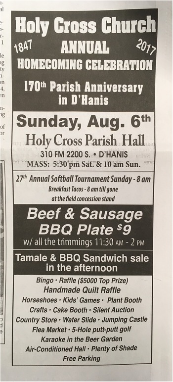
In August 2017, I turned off my GPS and stepped out of my rental car onto the dirt road beside Holy Cross Catholic Church in D’Hanis, Texas. I was a second-year PhD student from the northeast United States, and as a stranger in this small town, I felt viscerally out of place. The church picnic in D’Hanis is an annual homecoming event attended by family members from across the country, which I had learned about through a chance encounter with an ad in a local newspaper (Figure 1). Showing up alone to parties was not part of my archaeological training, and although I knew that doing so was a logical way to build community connections, that did little to reduce my nerves. I entered the church.
Phone photograph of the newspaper ad in the Hondo Anvil Herald for the Holy Cross Church annual homecoming celebration (Patricia G. Markert, 2017).

Figure 1 Long description
Holy Cross Church 1847 ANNUAL HOMECOMING CELEBRATION 2017 170th Parish Anniversary in D'Hanis Sundaycomma Aug. 6th Holy Cross Parish Hall 310 FM 2200 S. • D'HANIS MASS: 5:30 pm Sat. & 10 am Sun. 27th Annual Softball Tournament Sunday - 8 am Breakfast Tacos - 8 am till gone at the field concession stand Beef & Sausage BBQ Plate dollar9 wdivided by all the trimmings 11:30 AM - 2 PM Tamale & BBQ Sandwich sale in the afternoon Bingo • Raffle (dollar5000 Top Prize) Handmade Quilt Raffle Horseshoes • Kid's Games • Plant Booth Crafts • Cake Booth • Silent Auction Country Store • Water Slide • Jumping Castle Flea Market • 5-Hole putt-putt golf Karaoke in the Beer Garden Air-Conditioned Hall • Plenty of Shade Free Parking.
It turned out there was little time for nerves. The ensuing six hours were a whirlwind of introductions, trading contact information, and making plans. I met people who would become collaborators and friends over the next eight years. I wrote pages of fieldnotes that night, trying to capture names and details, but what quickly became clear is that developing relationships was not something I could meticulously plan. There is an openness inherent to relationship building and to community-based work, a shifting of personal accountability that extends beyond a research question or design—and that was a lesson I was only going to learn in community. There was no methodological roadmap for this: it was something community members and I would need to figure out together.
Despite months of background research and planning, this experience marked a clear beginning to the community-based projects that emerged over the next several years. I had come to Texas with preconceived ideas about the project and its research design. My initial research question was comparative: How did D’Hanis and its sister colony Castroville develop into distinctly different towns through time, despite shared origins as nineteenth-century Alsatian settlements in Texas (Markert Reference Markert, White and Dale2022a, Reference Markert2022b)? My research design included conducting oral history in both communities and mapping ruins in D’Hanis to re-create the layout of the original settlement. I had made some community connections when I had participated as a PhD student in my adviser Ruth Van Dyke’s archaeology project in nearby Castroville (Van Dyke Reference Van Dyke2017).
This preparation got me on the plane to Texas, but once I arrived, I was faced with a different kind of navigation, a different set of choices. The annual picnic was the start of several relationships, which multiplied as the project progressed and gradually pushed me beyond my original research design and questions. With others, I came to appreciate the ruins themselves as sites of memory, to question the ways that different migrations affected heritage and landscape, and to explore how digital methods could expand shared questions about and access to sites—none of which I had envisioned at the outset of the project.
In this article, I explore what came after the church picnic: the emergent methods that were informed, transformed, or prompted by engagements with community. Charting a course in collaborative or community-based work can be difficult. How do we communicate how to do archaeology with communities if there is no one-size-fits-all methodology? I do not frame this as a problem but a provocation, taking seriously the fact that community-based work is challenging and that being challenged makes us stronger researchers and research partners.
Community-based and collaborative approaches have transformed archaeological research over the past three decades (Montgomery and Fryer Reference Fryer2023; see also Agbe-Davis Reference Agbe-Davies2010, Reference Agbe-Davies2011; Atalay Reference Atalay2012; Colwell Reference Colwell2016; Colwell-Chanthaphonh and Ferguson Reference Colwell-Chanthaphonh and Ferguson2008; Franklin Reference Franklin1997; Little and Shackel Reference Little and Shackel2014; Nicholas et al. Reference Nicholas, Roberts, Schaepe, Watkins, Leader-Elliot and Rowley2011; Silliman Reference Silliman2008; Wylie Reference Wylie, Padovani, Richardson and Tsou2015). Archaeologists have addressed the best practices, challenges, and benefits of working with communities (e.g., Franklin Reference Franklin1997; Supernant and Warrick Reference Supernant and Warrick2014; Tully Reference Tully2007; Westmont and Clay Reference Westmont and Clay2021) in discussions that have found homes in publications like the Journal of Community Archaeology & Heritage (e.g., Cipolla and Quinn Reference Cipolla and Quinn2016; De Nardi Reference De Nardi2014; Rizvi Reference Rizvi2022). Some of the core goals of community and collaborative archaeology are the co-construction of knowledge, shared decision-making, and shared benefits from outcomes of the research at each stage of a project.
Colwell-Chanthaphonh and Ferguson (Reference Colwell-Chanthaphonh and Ferguson2008) proposed the concept of a “collaborative continuum” along which goals and relationships fluctuate and must be constantly assessed and negotiated over the course of a project (for an updated framework that includes colonial and Indigenous control, see Colwell Reference Colwell2016). There is no roadmap, no one-size-fits-all set of methods that works for every collaborative context (Chilton and Hart Reference Chilton and Hart2009:87), and no single “community” or “public” with a static set of interests in a site or the past (Agbe-Davies Reference Agbe-Davies2010; Supernant and Warrick Reference Supernant and Warrick2014). Working with communities requires flexibility, a willingness to listen and change course, a principled openness to challenge and growth, and an ongoing commitment to establishing what ethical archaeology looks like in dialogue with others (Ardren Reference Ardren2002; Supernant et al. Reference Supernant, Baxter, Lyons and Atalay2020). Sharing the particularities of our approaches—the stories and relationships that underlie the research—can be just as important as sharing the findings and outcomes.
For archaeologists, research with communities has been scaffolded by theoretical, methodological, and ethical scholarship and dialogue happening throughout the discipline (e.g., Beck and Somerville Reference Beck and Somerville2005; Chilton and Hart Reference Chilton and Hart2009; Little Reference Little2002; McDavid Reference McDavid2002, Reference McDavid2011; Pyburn Reference Pyburn, Okamura and Matsuda2011; Reid Reference Reid2022; Singleton and Orser Reference Singleton, Orser, Zimmerman, Vitelli and Hollowell-Zimmer2003; Supernant and Warrick Reference Supernant and Warrick2014). Black Feminist and Indigenous archaeologies have provided a model for community-centered and interdisciplinary approaches rooted in relationships and accountability, with several transformative works that ground archaeology in practices of care (Atalay Reference Atalay2012; Battle-Baptiste, Reference Battle-Baptiste2011; Supernant et al. Reference Supernant, Baxter, Lyons and Atalay2020; see also ongoing work at Estate Little Princess in Flewellen et al. Reference Flewellen, Odewale, Dunnavant, Jones and White III2022). Ethnographic archaeology and archaeological ethnography (Castañeda and Matthews Reference Castañeda and Matthews2008; Hamilakis Reference Hamilakis2011; Meskell Reference Meskell2005, Reference Meskell and Shankland2012), as well as approaches to applied, activist, and liberatory archaeologies (e.g., Atalay et al. Reference Atalay, Clauss, McGuire and Welch2014; Barton Reference Barton2021; D’Alpoim Guedes et al. Reference D’Alpoim Guedes, Gonzalez and Rivera-Collazo2021; Flewellen et al. Reference Flewellen, Dunnavant, Odewale, Jones, Wolde-Michael, Crossland and Franklin2021; Fryer Reference Fryer2023; Lans Reference Lans2024; McGuire Reference McGuire2008; Mullins Reference Mullins2011; Stottman Reference Stottman2018), offer provocations toward reflexive and relational research with others. These works demonstrate the value of locating ourselves within our research, with many doing so through the critical work of narration.
All research constitutes a form of relationship building, a process that generates not just data but also connections between researchers and the others involved (Lyons and Supernant Reference Lyons, Supernant, Supernant, Baxter, Lyons and Atalay2020:10; see also Wilson Reference Wilson2008). Community-based archaeology centers this relationship building and actively engages with the possibilities and constraints of these relationships by approaching communities as processes, rather than static places or things (Agbe-Davies Reference Agbe-Davies2010:385). Although not all community-based projects may identify as “collaborative,” they all require collaboration (i.e., at its most basic, working with others).Footnote 1 Here, it is useful to approach collaboration as a question that frames an ongoing dialogue in a relationship: What does it mean to work together, and how will we accomplish it? Answers require continual negotiation. They are variable and changeable, full of those possibilities and constraints inherent to relationships.
Because there is no roadmap for work with communities, it is useful to look at everyday practice for inspiration: how methods emerge from relationships, how relationships affect the research process, and what types of engagements are prompted by archaeology during and after archaeological projects. This requires some tacking back and forth between method and context. In the following sections, I reflect on three methods that, prompted by relationships or engagements in community, emerged or changed during the course of the project: oral history and narrative analysis, community-based archival research, and close-range photogrammetry. Instead of offering guidelines or instructions, I narrate the process and consider how working with others shaped the project’s questions and methods. I also address the possibilities and challenges of community-based work, recognizing that we occupy different privileges, positions, and bodies as researchers and that this too shapes projects.
A Brief Detour into Historical Context
I draw the following examples from the Old D’Hanis Archaeological Mapping Project and Castro Colonies Oral History Project, which explored the ways that place-making emerged in the wake of nineteenth- and twentieth-century Alsatian, German, and Mexican migration to Medina County, Texas (Markert Reference Markert2020, Reference Markert, White and Dale2022a, Reference Markert2022b). Medina County is located on the unceded ancestral homelands of the Ndé Kónitsąąíí Gokíyaa (Lipan Apache). It is a settler-colonial landscape, divided, mapped, and settled through the Republic of Texas’s adoption of New Spain and Mexico’s empresario system, which offered land grants to colonization companies in exchange for settlement (Weaver Reference Weaver2005). D’Hanis was one of four German and Alsatian colonies founded in the 1840s by empresario Henry Castro on the land west of San Antonio (Jordan Reference Jordan1966; Morgenthaler Reference Morgenthaler2009; Van Dyke Reference Van Dyke2017; Waugh Reference Waugh1934; Weaver Reference Weaver2005). The presence of the towns was strategic, enabling the Republic of Texas to populate and secure territory west of its growing cities against incursion from Mexico while advancing a campaign of ethnic cleansing against the Lipan Apache and the Comanche Nation (Ayres Reference Ayres1995; Babcock Reference Babcock2016; Campbell Reference Campbell2003; Panich and Schneider Reference Panich and Schneider2014). The contracts specifically stipulated the recruitment of white European colonists (Cohen Reference Cohen1897).
D’Hanis was the last and farthest west of Castro’s colonies. Alsatian and German settlers built rock houses and a Catholic church there, and their descendants spoke a dialect of Alsatian until World War II (Roesch Reference Roesch2012). After the construction of the railroad in 1881, many families relocated a mile and a half to New D’Hanis, which developed around the depot. The rock homes of the old settlement were later rented and purchased by Mexican migrants fleeing the Mexican Revolution; they encountered social, ethnic, and linguistic segregation in early twentieth-century Texas (De León Reference De León1985; De León and Stewart Reference De León and Stewart1983; Montejano Reference Montejano1987).
Within this landscape, the research emerged as a multifaceted and interdisciplinary process. My initial questions focused on the nineteenth-century Alsatian past before expanding to encompass the town’s more layered histories, and I drew on new methods as relationships and circumstance prompted me to think outside the frameworks I was familiar with. Eventually, I defended and published a dissertation. To understand project trajectories, we often take a big-picture approach, but in the following sections, I examine how research directions change during smaller moments, interactions, or experiences in the field.
From Oral History to Narrative Analysis
In August 2018, I met a 93-year-old resident of D’Hanis at the local Dairy Queen. We sat at the table where she would eat lunch each day and discussed my work and her experiences while eating fish sandwiches. Past and present converged over fast food and ice cream. She asked whether I had time to take a drive, and I told her I did. We finished eating and went to my rental car. From there, we drove to the nearby Hondo Airfield where she had worked as a teenager during World War II, a period when speaking German or Alsatian in public was prohibited. The car’s air conditioner ran at full blast while she spoke, a necessary annoyance given the heat. In the car, listening to her above the hum, I began to consider the ways that World War II had profoundly shaped landscape and identity in the community.
That same month, I interviewed one of the last fluent speakers of the Texas-Alsatian dialect. Born and raised on a farm outside Castroville, he did not learn English until he attended elementary school in town. He and others told me how Alsatian-speaking Texans would refer to outsiders from San Antonio as Amerikaners well into the twentieth century. As an adult, he had become somewhat of a celebrity in Alsace and traveled there regularly. With my tape recorder in hand, we sat in his pickup truck as he played me a CD he had recorded with a country and western band in France, translating classic country songs into Alsatian. I began to consider the ways in which language was inseparable from understanding space, history, and identity in this place.
Days later, I found myself in another pickup truck with a Mexican American resident of D’Hanis who took me to visit the house where he had lived as a child with his grandparents. It was now in ruins. His grandfather had escaped the Mexican Revolution and arrived in D’Hanis in the early twentieth century during a time when the town was deeply segregated, with a Spanish-speaking and English-speaking church and school. He purchased the rock house in the 1940s, which had been built nearly a century earlier by an Alsatian migrant. In a separate interview, his sibling reflected on living in that house and shared stories about how speaking Spanish was punished in school well after desegregation in the 1950s. When the archaeological crew later recorded the rock structure, these stories layered across the built landscape, and I began to consider what that might mean for analyzing and presenting our findings.
These are three examples of how oral history encounters prompted shifts in project questions and approaches. Conducting oral histories was an early part of the research design for the project.Footnote 2 Based on my previous oral history experience (Barton and Markert Reference Barton and Markert2012), I was prepared to conduct interviews in a variety of settings, recognizing that the traditional sit-down interview, although preferable for sound quality, was not always possible in the field. Often, I talked with people in cars and trucks. After an initial informed consent process, I would keep my recorder handy in whatever setting I was in, following the lead of my interviewees. Sometimes interviews would unfold over multiple sessions and in a variety of settings as we picked up threads from previous conversations.
The nature of oral histories is emergent, so although this did not constitute a shift in methods, the conversations began to shape the way I approached other parts of the project, such as my analysis of archaeological landscapes (i.e., ruins) and the ways I approached multiple migrations in my research question. Understanding the multilayered conversations we were having about place and history demanded interdisciplinary analyses. Drawing from prompts during my coursework in the four subfields, I turned to linguistic anthropology methods to make sense of the ways people narrated these landscapes, their migration histories, and language through time.
Oral history encompasses both method and data (Abrams Reference Abrams2010). As a method, it decenters the archaeologist as the sole producer of knowledge (McDavid Reference McDavid2002); creates opportunities for ongoing dialogue between the archaeologist and community (Beck and Somerville Reference Beck and Somerville2005); creates space for the co-production of knowledge that challenges erasure and contested heritage narratives (ike Reference ike2024; Reid Reference Reid2022); positions archaeological sites as sites of memory (Moshenska Reference Moshenska2007); and highlights archaeological work as a situated, meaningful, and political project (González-Tennant Reference González-Tennant2014). As an anticolonial methodology, oral history can create space for community-driven dialogues that recenter narratives away from the colonial frameworks that forefront violence and toward generative frameworks rooted in experience and hope-based resistance (Montgomery Reference Montgomery2023). In the world of community-based and collaborative archaeology, oral history is a tool for making archaeology relevant, accountable, and dialogic in both practice and interpretation.
As data, oral histories function as sources of narrated information that can contribute to more holistic interpretations of the past. Abrams (Reference Abrams2010) provides several critical lenses through which we might make sense of oral historical data: as performance, memory, and co-created document, among others. As an archaeologist, I wanted to treat the oral histories I collected with the same systematic consideration as the archaeological data. I also recognized that in my oral history work I was recording stories with descendants of European settler communities and Mexican migrants of the twentieth century. The contested histories we explored together involved themes of settler colonialism, Indigenous displacement, segregation, and notions of belonging. There is the risk of simply perpetuating settler narratives and mythologies without analytical care. This, and some of the unexpected provocations of the encounters discussed earlier, encouraged me to use narrative analysis to understand not just what people were saying but also how they were using language to create meaning, memory, and identity through storytelling (De Fina and Georgakopoulou Reference De Fina and Georgakopoulou2012; Perrino Reference Perrino2011, Reference Perrino, Fina and Georgakopoulou2015).
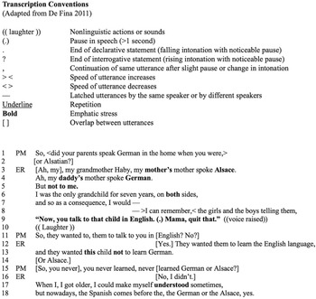
We recorded more than oral history interviews over the course of the project. After transcription, I coded them based on emergent themes. I then selected narratives, re-transcribed them based on linguistic conventions (Figure 2; De Fina Reference De Fina2011), and conducted narrative analyses to examine patterns in language, storytelling, and content to understand strategies that people were using to make and convey meaning about place, history, and migration. Some examples of patterns were interactional elements of the interview itself (Wortham Reference Wortham2000), the racialization of language (Rosa Reference Rosa2016), how narrators call on known and imagined “figures of personhood” (Koven Reference Koven, Fina and Georgakopoulou2015) or evoke other’s voices in their own storytelling (Wortham Reference Wortham2001), how they navigate notions of time and space (Bakhtin Reference Bakhtin1981; De Fina Reference De Fina2003; Dick Reference Dick2010; Perrino Reference Perrino, Fina and Georgakopoulou2015), and how they orient themselves and others in the world (Modan and Shuman Reference Modan and Shuman2011). These linguistic analyses informed how I analyzed both my archaeological and narrative data, prompting me to think about the ways people also draw on meaningful concepts in material interactions (Bakhtin Reference Bakhtin1981). They also helped me make sense of space and time in multigenerational processes of place-making, from settler-colonial mythologies to the spatialization and segregation of language (German, English, and Spanish; Markert Reference Markert2022b).
Linguistic anthropology transcription conventions (adapted from De Fina Reference De Fina2011) and an example of an oral history excerpt, re-transcribed for narrative analysis as part of the Castro Colonies Oral History Project (Patricia G. Markert, 2022).

Figure 2 Long description
The table has two sections. The first section lists transcription conventions with two columns: 'Symbol/Notation' and 'Meaning'. Symbols include (.) for nonlinguistic actions, (..) for pauses over one second and (.) for end of statements. The second section is an oral history excerpt with columns 'Speaker' and 'Utterance'. It features a dialogue about language use in a family, highlighting the preference for English over German or Alsace. The table contains approximately 18 lines of dialogue. The conventions are used to interpret the excerpt.
I sent the final product—the published dissertation—to people I interviewed and included in the analysis, some of whom have (self-reportedly) now read my full dissertation. Some have even given me paginated notes. This serves as a reminder that data collection and publication are mere moments in a broader conversation that is the co-production of knowledge within communities. Oral history also reminds us of this broader conversation: despite scholarly efforts to diligently record, transcribe, publish, and set things on paper, oral narratives continue to exist in a more dynamic sphere of relationships and dialogue. We enter this sphere when we work with communities. It provides necessary perspective to the work that we do.
Into the Community Archive(s)
In 2017, in the parking lot of a public library, I met a local resident who would later become a regular partner in historical research. From the back of his pickup truck, he pulled out a box filled with stacks of old papers—old letters and correspondence, receipts, ledgers, jail records—all from around the 1890s. He told me that as a child, he had saved these papers when one of the old buildings in D’Hanis was demolished in the 1950s. He also had a binder of hundreds of photographs that he had accumulated over the years by visiting other community members and scanning their images. This was my first introduction to a community culture of archiving in Medina County, a practice that was rooted deeply in place, history, and relationships. He allowed me to take the box into the library and create digital records for my own growing collection of materials. This experience repeated itself often throughout the next several years, and I came to realize that the process of archiving was itself an act of community building and place-making (Bastian and Flinn Reference Bastian and Flinn2019; Flinn Reference Flinn2007; Flinn et al. Reference Flinn, Stevens and Shepherd2009).
Archival research is a core component of historical archaeology, and archaeologists have incorporated archival materials into projects in creative and interdisciplinary ways (Beaudry Reference Beaudry1988; Flewellen Reference Flewellen2020; Norton Reference Norton2020; Platt Reference Platt2020; see also ike [Reference ike2024] and Alicia Odewale and Parker VanValkenburgh’s Mapping Historical Trauma in Tulsa (MHTT) from 1921–2021 Project). I originally approached archival research as background research, working with established archives like the Portal to Texas History (University of North Texas Libraries) and University of Texas San Antonio’s (UTSA) Special Collections to piece together historical context for the projects. I expected I would encounter primary source materials like photographs in people’s homes, but as I developed relationships in the community, scanning personal archives emerged as its own form of fieldwork.
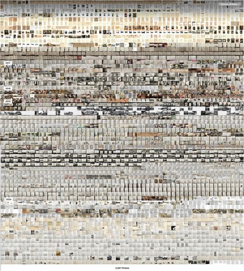
At nearly every house that I visited, someone had some form of historical documentation that they retrieved for me to digitize. In response, I developed an on-the-go digitization method to quickly scan materials, which consisted of an iPad Pro, a scanning application (iScanner), a portable arm to hold the tablet parallel to the table, a foldable LED light, and a piece of black poster board. I scanned boxes of old newspapers and photographs, arrest records and store ledgers, letters that had been translated from German, personal collections, and scrapbooks. Sometimes, as in this section’s opening anecdote, the archive traveled to me. I recorded materials in restaurants and coffee shops. I also digitized physical materials in businesses—maps and plats at local surveyors’ offices—and institutional archives, such as folders of newspaper clippings and photographs at the Institute of Texan Cultures at UTSA. Not all these were primary source materials. Folks shared copies of local histories, pamphlets, and published materials (e.g., Jack Finger’s sell-published 2012 book, A Walking Tour of Beautiful Downtown D’Hanis . . . With Detours), and I scanned these as well. By 2019, I had amassed more than 3,500 digital images, including photographs, maps, letters, self-published family histories, newspaper clippings, and albums (Figure 3).
Nearly 4,000 digital scans from community-based archival research, taken using an iPad Pro and compiled/organized by date in the Apple photos app (Patricia G. Markert, 2021).

Figure 3 Long description
The image shows a large collage composed of numerous small images arranged in a grid pattern. The images are organized in rows and columns, creating a mosaic-like effect. Each small image appears to be a distinct photograph or document, contributing to the overall visual complexity. The collage is densely packed, with minimal spacing between the individual images. At the bottom, there is a label stating '3,627 Pictures'.
At the beginning of the project, I underestimated the sheer amount of archival material that community members would share with me during our work together. The items I scanned for my own research were a mere sample of a much larger, ever-evolving community archive. Through my own process of creating a digital archive, I began to recognize how relationships, movement, and trust factored into the ways that people navigated archival research and shared materials in community. I was being invited into spaces of archival expertise and allowed access to personal decisions and collections. Importantly, this archival network existed long before I arrived, and my presence became yet another part of that living archive.
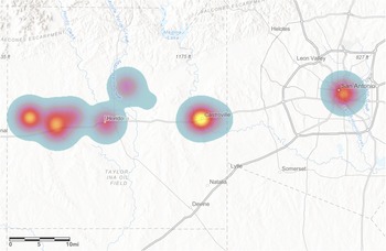
My methods for digitizing archival records, as it turned out, also produced a way to visualize the day-to-day interactions on which community-based research is built. When I sat down to sort through the material, I realized that the iPad had an added feature—it geolocated each scan—allowing me to map an entire two years of archival research onto the landscape using ArcGIS (Figure 4). Given that the archive reflected direct work with community partners, it became a manifestation of the relationships and movements needed to participate in this practice of community archiving. It may not have produced a roadmap, but it reflected the routes and places we occupied together during the research process. It also opened up possibilities for further analysis, including an examination of the ways that archival materials repeat across this landscape (e.g., representing shared materials) or present gaps, fissures, and erasures in community and history (Flewellen Reference Flewellen2020; Hartman Reference Hartman2008), such as the division between Mexican and Alsatian-German representation in the materials, a present-day reflection of the segregated landscape under Jim Crow and its legacies.
Heat map generated in ArcGIS Online by inputting the geotagged locations of digital archival scans taken using an iPad Pro during fieldwork (Patricia G. Markert, 2021).

Figure 4 Long description
The heat map displays geotagged locations in Texas, focusing on areas around San Antonio, Castroville and Hondo. The map uses color intensity to indicate the density of locations, with brighter areas representing higher concentrations. San Antonio shows a significant cluster, as do Castroville and Hondo. The map includes a scale bar indicating distances in miles and major roads and towns are labeled, providing geographic context. The distribution suggests concentrated activity in these regions, with less density in surrounding areas.
The nature of the community archive is similar to that of the oral histories: it exists in and through relationships, in a state of constant flux, and is fluid where my recording and publishing practices attempted to make it concrete. My research archive is part of a broader practice of collecting that continues in the community, and understanding it as such prompted me to think about archival materials—and the histories and identities inherent to those practices of collecting—in ways I might not have otherwise.
Close-Range Photogrammetry: Ruins as Sites of Digital Engagement
When it came time to record the ruins of Old D’Hanis, my team and I arrived with notebooks, iPads, hard hats, hedge clippers, and a chainsaw. The archaeological component of the research took place in November and December 2018, building on a year of preparation and community-based exploratory work. With the launch of the Old D’Hanis Archaeological Mapping Project, we set out to record six structures that dated to the early decades (1847–1860) of the Old D’Hanis settlement: five rubble-rock ruins and one log dogtrot cabin.Footnote 3
The goal of the archaeology was to record and map the structures and their locations using a range of methods, from architectural elevation drawing to geographic information systems (GIS). This contributed to an analysis of architectural and spatial decisions made by Alsatian and German migrants in the early decades of the settlement. After more than a year of community conversation, I was also interested in the decisions and place-making practices of later occupants who shaped the buildings, including generations of descendants and Mexican families who made the old rock houses their homes in the early twentieth century. As we cleared the structures (Figure 5) and then drew and photographed them, we were attentive to the biographies of the buildings themselves: a change in building material, an addition or expansion, evidence of remodeling, or the (occasional) inclusion of modern amenities like plumbing or electricity. The crew conducted surface survey, mapped areas of the structure by hand, photographed surface finds and architectural details using a project iPad, and completed scaled elevation drawings of walls and significant architectural features such as fireplaces (Figure 6).
Photographs of one of the ruins recorded by the Old D’Hanis Archaeological Mapping Project, before and after the crew cleared overgrowth (Patricia G. Markert, 2018).

Figure 5 Long description
The image shows two photographs side by side. The left photograph depicts a ruin covered with dense vegetation, including bushes and small trees, obscuring much of the structure. The right photograph shows the same ruin after the vegetation has been cleared, revealing the stone walls and rubble. The walls are made of irregularly shaped stones, some of which are crumbling and there is visible damage and wear on the structure. The ground is covered with rocks and some greenery remains around the base of the walls.
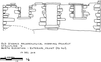
Architectural elevation drawing of one of the ruins recorded by the Old D’Hanis Archaeological Mapping Project (Patricia G. Markert, 2018).

Figure 6 Long description
Hand-drawn elevation of a stone wall face with irregular rectangular blocks and broken wall edges at the far left and far right. Three main openings are shown across the wall: a narrow opening at the left, a larger central opening with a rectangular lintel and a small rectangular step at its base and a smaller rectangular opening to the right with a framed outline. A dashed curved line runs across the lower left portion of the wall area. Text at the lower left reads “OLD D’HANIS ARCHAEOLOGICAL MAPPING PROJECT” and “STRUCTURE 7”. Below that it reads “NORTH ELEVATION – EXTERIOR, FRONT (PD 701)”. A date line reads “17 DEC 2018”. At the bottom left is a scale bar labeled “2 METERS” with a midpoint label “1 M”. Near the bottom center is a north arrow labeled “N”, with the arrow pointing downward.
After clearing, we photographed the extant walls and surrounding landscape to create 3D models of the structures.Footnote 4 A month or so before heading to the field in 2018, I had learned about close-range photogrammetry as an archaeological field method and decided to add it to the project. This choice ended up shaping the project in significant ways. At the time, photogrammetry was emerging as an accessible, fast, and low-cost method for imaging sites, buildings, objects, and landscapes with a high level of accuracy and precision (Prentiss Reference Prentiss2016; Sapirstein Reference Sapirstein2016; Sapirstein and Murray Reference Sapirstein and Murray2017; Yamafune et al. Reference Yamafune, Torres and Castro2017; Yilmaz et al. Reference Yilmaz, M. Yakar and Dulgerler2007). Close-range photogrammetry generally consists of photos taken by hand. Although many projects use drones to capture photographs, which provides an exciting set of possibilities, unmanned aerial vehicles (UAVs) are not always the most accessible or cost-effective option, and trees and brush would have made their use difficult at several of the ruins we recorded. Although time and effort are trade-offs, close-range photogrammetry provides a layer of relative accessibility to the 3D modeling of architectural features. It is possible to implement this method with a DSLR camera, a laptop with a graphics processer, and photogrammetry software such as Agisoft Metashape Pro.Footnote 5 I included photogrammetry as a method late in the research design process in part because I was curious—would it work?—but also based on a strong sense that the 3D models would enable important types of engagement for the research and in community.
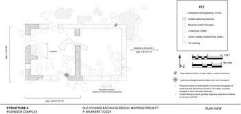
The models made a range of analytic options available to me digitally: creating scaled plan views of the structures in Adobe Illustrator (Figure 7), setting scales and measuring between points, and zooming in and out to reassess structural details. But beyond the research, the models became new sites for community connections and knowledge sharing. This builds on an emerging body of literature on digital, multimodal, reflective, interdisciplinary, and community-based approaches to mapping and GIS in archaeology (De Nardi Reference De Nardi2014; Gillings et al. Reference Gillings, Hacıgüzeller and Lock2019; González-Tennant Reference González-Tennant2016; Norton Reference Norton2020; Platt Reference Platt2020; Warner-Smith Reference Warner-Smith2020; see also Bodenhamer et al. [Reference Bodenhamer, Corrigan and Harris2015] for perspectives from the digital humanities).
Digital plan view created in Adobe Illustrator using scaled 3D model generated in Agisoft MetaShape Pro (Patricia G. Markert, 2021).

Figure 7 Long description
The plan view illustrates Structure A at the Old Dvāravatī Archaeological Mappings Project. The layout includes limestone stone blocks in situ, visible wall foundations and limestone rubble. A key indicates symbols for these elements, along with a fireplace and tin roofing. The structure measures 9.4m by 17.1m. Limestone Structure 3 is noted to the north. The map includes a scale in feet and meters and a north arrow for orientation. The key provides details on the representation of different materials and features within the site.
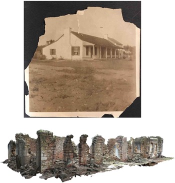
Many of the sites we recorded remain inaccessible for several reasons—safety, private property, or difficult terrain—so the models became an important point of access. Although we conducted site visits and tours during fieldwork, many of the people I worked with were in their eighties and older. Visiting a ruin, which could require some hiking and climbing over tricky terrain, was simply not possible. During and after fieldwork, I was able to bring preliminary models to people’s homes or to community events, allowing us to compare old photographs and discuss our observations of the ruins (Figure 8). The ruins were sites of memory and nostalgia, often with direct familial connections, so the ability to view and explore them virtually was a valuable option for those with limited access and mobility.
Nineteenth-century photograph of one of the structures recorded by the Old D’Hanis Archaeological Mapping Project alongside the 3D model of the ruin, generated using Agisoft Metashape Pro (photograph courtesy of E. Rothe; 3D model by Patricia G. Markert, Reference Markert2020).

Figure 8 Long description
The image shows a nineteenth-century photograph of a building with a porch and multiple windows. Below it is a 3D model of the building's ruins, featuring a series of stone columns and walls in a state of decay. The photograph and model are presented side by side for comparison.
The models also became, and remain, sites for remote engagement. In 2020, sitting in an apartment in Eugene, Oregon, during the early months of the COVID pandemic and with the thick smoke of the wildfires outside my window, I presented the 3D models to community members at a Castro Colonies Heritage Association meeting on Zoom. We were able to look closely together at architectural details despite the thousand-mile distance. Later, in 2025, I sent files from a more recent model I had made of St. Dominic’s Church (this time using a DJI Mavic 3E drone) to community partners in Texas from my home in London, Ontario. They 3D printed the model, adding structural elements as part of a local effort to stabilize the ruin. In 2018, we could not have envisioned either scenario, but the process of photogrammetry had enabled a continued conversation around the archaeology that transcended time, space, and circumstance.
Layered Pasts and Emergent Interdisciplinarity
During archaeological fieldwork in 2018, a crew member and I conducted a driving tour of D’Hanis with a then 99-year-old member of the community, someone who became a good friend over the course of the project and has since passed away. At her prompting, we slowed at the ruins but stayed in the car, glimpsing them through the sparse brush. A few buildings were visible for the first time in recent memory due to the clearing efforts of the crew.
Stopping at one structure, which was little more than a few standing walls, she told us, “This was a beautiful house. Oh, I loved this house.” We talked about her memory of the building, its L-shape and brick patio that was now barely visible under a thin layer of soil. She reminisced about the woman who had lived there, a rather severe aunt whom she remembered walking to town in her black dress each day. Others in the car, members of a younger generation, talked about playing in the ruins of the house and being chastised by their parents. The archaeological crew had just finished recording the site, so drawings, architectural details, and surface finds were fresh in our minds. Several different engagements with place mingled in the car as the ruin sat silently in our view. I was reminded of an earlier driving tour with another local resident and friend, a member of D’Hanis’s Mexican American community, and his memories of the solid walls of his childhood, now a ruin.
What these moments demonstrate is that although I am separating methods in this discussion, they and the data they produced were inseparable in practice. One final methodological challenge that emerged was how to engage with the wide range of interdisciplinary data collected during the project. How do we present multifaceted data in a way that reflects the process of its creation—the way that community-based work prompts us toward interdisciplinary research? I reflect on this briefly, acknowledging that the answer to this question is a long-term one that is still in progress.
These landscapes of memory are not visible in the ruins we recorded, but they became legible through these engagements with people and place. When I wrote the architectural analyses for the buildings after three years of community-based fieldwork, the result was an interdisciplinary layering of data: oral histories like these alongside archival fragments, drawings, and models of the ruins themselves. Learning to thoughtfully layer interdisciplinary data was yet another method that community-based work made necessary. Data drawn across methods create new conversations and insights, allowing us to think about places and people’s engagements with them across time and space. In my dissertation—the first publication of these results—the layering of data created multigenerational biographies of the buildings and their residents. They traced the histories of the structures across multiple periods of occupation, use, and abandonment, examining the different meaningful engagements that families and communities formed with the buildings through time, across both Alsatian-German and Mexican migration to D’Hanis.
We are continuing to experiment with interdisciplinary applications six years later. In June 2024, with a team of students from Western University, we traveled to Medina County to present the initial version of a virtual archaeology game called Discover Old D’Hanis. This game layers the reconstructed landscape of D’Hanis (ca. 1880) with 3D models, artistic reconstructions, archival data, archaeological notes and photographs, and excerpts from oral histories from German, Alsatian, and Mexican descendants. Players can walk through the town, discovering data points and piecing together a story of the place, its history, and its community through time. The student team comprised two fourth-year computer sciences students, who designed the virtual world and gameplay, and a master’s student in music, who contributed historic sound design and an original composition based on German folk music.
Nearly 100 community members—many familiar faces and many new ones—attended the event. In an astonishing, entirely unprompted moment, members of the older generation in the crowd began to sign a German folksong as the music student presented the songs that inspired her work (Fohn Reference Fohn2024). This new arm of the project is a work in progress, but it illustrates how new applications and research directions continue to emerge through ongoing conversations with students and community members.
Challenges and Opportunities for Community-Based Archaeology
Working with others is challenging work because relationships are challenging work. An archaeology rooted in relationships has the potential to challenge, unsettle, and change us (Kelvin and Hodgetts Reference Kelvin and Hodgetts2020; Lyons and Supernant Reference Lyons, Supernant, Supernant, Baxter, Lyons and Atalay2020:10; see also Rizvi Reference Rizvi, Supernant, Baxter, Lyons and Atalay2020). The relationships through which we build community-based projects, like any relationship, are understandings between people. In whatever capacity, we are sharing our lives and something of ourselves with others. It is a matter of trust as much as ethics, and it is a two-way-street.
The positions we occupy as researchers require an ongoing commitment to transparency, humility, accountability, and an openness to change and new direction (see Westmont and Clay Reference Westmont and Clay2021). At the same time, centering community requires recognition that our titles and resources are hollow without welcome and access from those with (and for) whom we work. Outside academic or professional frameworks, sharing power and building trust may not resemble traditional methods like meetings or discussions. They might look like sharing a meal, accepting an invitation, taking a car ride, attending a funeral, or getting to know each other’s toddlers and grandchildren as years pass. My daughter has now joined me in Texas three years in a row. She has spent time at people’s homes and at community events, ridden in trucks on ranches, and fed sheep that graze the ruins of Old D’Hanis (Figure 9). Many of my long-term community partners have watched her grow, and she knows their names. I have been privileged to have her join me, though managing childcare alongside project and community commitments has taken considerable work (Reference Seifert and Spencer-Wood2025). Her presence has become an indelible part of the fabric of the project.
My daughter and I at the children’s archaeology exhibit I designed for the Castro Colonies Living History Center, Castroville, Texas, taken two years apart (photos taken by Jeremy Trombley, August 2023 and June 2025).

Figure 9 Long description
The first image shows a woman and a child sitting at a sand table in an archaeology exhibit. The woman is using a brush, while the child points at something in the sand. The second image shows the same woman and child standing at the sand table. The woman is holding a tool and the child is looking at the sand. Various tools are scattered on the table and informational panels are visible in the background.
One challenge here—in addition to doing archaeology as a parent (Camp Reference Camp, Muhammad and Neuilly2019)—is nurturing relationships beyond the bounds of a research project. Doing so can be wonderful and generative, but our ability to build long-term relationships as archaeologists, and often as outsiders, may not always match our willingness or desire. Constraints like time, funding, graduate degree timelines, travel, family, and the demands of new research projects exist for everyone in different variations and capacities, and they too change over time (Rizvi Reference Rizvi, Supernant, Baxter, Lyons and Atalay2020). There is no easy answer or one-size-fits-all solution, except for a commitment to dialogue and transparency, a respect for the very real work of building relationships, and an awareness of our limitations.
It is also important to recognize that it is often, if not always, a privilege to engage in community-based research as an academic. A roadmap to community-based practice does not exist because we, as researchers in community, occupy different identities, bodies, and social privileges that shape the way we move through the world with others, as well as our own experiences of safety and access. The research methods I describe here are situated and contextualized by my presentation as a white, able-bodied, cisgender woman in South Texas. As a researcher, I can confront issues of racialization, segregation, and settler colonialism from a place of relative safety, if not without some discomfort. Many places in the United States, including the state of Texas and farther afield, are taking strategic legislative, political, and policy-based actions to exclude and harm BIPOC, LGBTQAI2S+, and immigrant members of their communities, as well as archaeologists or students seeking to do this type of work. Indeed, fieldwork and professional settings writ large can still be unsafe spaces for many archaeologists, particularly minoritized members of the discipline (e.g., Hodgetts et al. Reference Hodgetts, Supernant, Lyons and Welch2020; Markert et al. Reference Markert, Hodgetts, Cantin, Mallet Gauthier, Lyons, Supernant, Welch, Wiley and Dent2025; Meyers et al. Reference Meyers, Horton, Boudreaux, Carmody, Wright and Dekle2018; Voss Reference Voss2021a). This raises ethical issues for community-based archaeology that we must collectively address in our politics and professions (D’Alpoim Guedes et al. Reference D’Alpoim Guedes, Gonzalez and Rivera-Collazo2021; Franklin et al. Reference Franklin, Dunnavant, Flewellen and Odewale2020; ike et al. Reference ike, Miller and Hartemann2020; Voss Reference Voss2021b).
Collaborative approaches are time-consuming and expensive; even when we get creative, field research costs money and relationship building takes time. I was fortunate to receive funding to do this work from both local and national sources, all of which expressed support for community-based approaches. Financial barriers already pose steep obstacles to entering and succeeding in archaeology (Heath-Stout and Hannigan Reference Heath-Stout and Hannigan2020). Engagements with community, collective project planning, public-facing outputs, and maintaining relationships can mean slower routes to publication and other traditional milestones on the tenure track. The professional landscape is changing slowly, but community-based work remains challenging to fund (Montgomery and Fryer Reference Fryer2023), even though targeted funds like the Wenner-Gren Engaged Anthropology Grant offer opportunities that did not exist a decade ago.
Concluding Thoughts for Paths Forward
As Natasha Lyons and Kisha Supernant write in their introduction to Archaeologies of the Heart (Reference Lyons, Supernant, Supernant, Baxter, Lyons and Atalay2020:10), “Without the relationships we build, archaeology would not be possible, yet we do not always appreciate the impacts those relations have on the ways knowledge gets generated in our field and the ways we interpret the past.” When I started this project, I had a research design: I sought to compare two nineteenth-century towns using a set of methods that seemed appropriate to the task: oral history, archaeological survey and mapping, and some archival research. On paper, it is easy to check the boxes: I used those methods, these were the limitations, these were the results. But what I had not quite anticipated was the power of relationships and the ways they prompted me in new creative directions throughout the process. The dissertation I wrote four years later reflected a shared exploration of space, archives, ruins, and stories that exceeded the bounds of what I alone would have thought possible when I arrived at Holy Cross Church in 2017. Rather than engaging with a single migration event, it reflected the many intersecting migrations that shaped the area (Markert Reference Markert2020), its (often contested) heritage, and the vibrancy of its communities.
Being able to develop, communicate, and execute a research design is a necessary skill in archaeology, one I now have the privilege of teaching graduate students in my classes. In teaching and mentoring, we can also take care to orient students to the flexible and relational realities of fieldwork with communities. Methods may change. Projects will change. The product may not be what we envisioned, but it will reflect the relationships we developed along the way, and those relationships and experiences have the potential to shape the project as much as (if not, at times, more than) our initial conceptions.
This article has been an exploration in charting the ways that methods emerge in conversation with community and how relationships lead us in new directions as we move through the research process. It has also been a practice in narrating the small moments and interactions that shape projects and their methods. There is no roadmap for community-based research, but there is the work of building and navigating relationships and of being open to the occasionally unexpected directions that research can take when we work with others. In hindsight, walking into the church at the start of this project was a practice in confronting the unknown and a lesson in letting go. It may not have been outlined in my research design, but the act of showing up and being present—that day in 2017, and all the times that came after—became one of the most critical and necessary methods for building a community-based project. When we locate ourselves in community, we follow each other’s lead.
Acknowledgments
A heartfelt thank you to the many people from Medina County and farther afield who contributed to this research through oral histories, archives, and time spent in friendship and conversation. You welcomed me into your community, homes, histories, and families over the past several years, making this project possible. To Polo Rodriguez, Elsie Rothe, and Melvira Carle, your knowledge and guidance shaped this project, and I miss each of you dearly. Thank you to the Castro Colonies Heritage Association for providing generous support at each stage, to the property owners in Old D’Hanis for making the archaeological work possible, and to Holy Cross Parish and the Archdiocese of San Antonio for facilitating photogrammetry of St. Dominic’s Church. I am grateful for the continual support and guidance of my adviser Ruth Van Dyke and to my dissertation committee, Randy McGuire and Sabina Perrino, whose advice guided this project from start to finish. Thank you to my field crew, Hunter Crosby, Emily Sainz, and Nolan O’Hara and the Discover Old D’Hanis team, Michael Salton, Emily Missetta Grant, Terrance Ju, and Hui Yi Joyce Lee. I would also like to thank my reviewers and Jeremy Trombley for thoughtful and constructive feedback on earlier drafts and Yarubi Diaz Colmenares for the Spanish translation of the abstract. These acknowledgments are the tip of the iceberg on a project like this, so I extend my gratitude to everyone else who made this—and continues to make this—work possible. Thank you.
Funding Statement
This work was supported by the Wenner-Gren Foundation under Grant No. 9706, the National Geographic Society under Grant EC-402R-18, the Council of Texas Archeologists under a 2018 Student Research Grant, the Medina County Historical Commission under a 2020 Research Grant, the Mellon Foundation / American Council of Learned Societies under a 2020 Dissertation Completion Fellowship, the Western University Faculty Research Development Fund (FRDF), and the Binghamton University Graduate Student Employees Union (GSEU) Professional Development Award.
Data Availability Statement
The oral history and archival data from the project were collected under Institutional Review Board (STUDY00000108) approval through Binghamton University and are not available publicly. The 3D models generated as part of the project are publicly available through the project’s Sketchfab.com page, www.sketchfab.com/fieldnotesfromtexas. At the time of publication, an early-access version of the Discover Old D’Hanis game is available for free download on Steam, with instructions and updates posted to www.discoverolddhanis.com.
Competing Interests
The author declares none.


 Open access