


Introduction
Ancient long-distance trade foreshadowed the development of international commerce and attests to a process of pre-modern globalisation. The connection between economic developments and the road networks in Eurasia and Africa in the pre-modern periods has been established in several case studies. The famous ‘Silk Roads’ that connected China to Western Asia (Hansen Reference Hansen2012; Graf Reference Graf, Wilson and Bowman2017), the trading routes across the Sahara (Ross Reference Ross, Kratli and Lydon2011; Wilson Reference Hansen2012; Braun & Passon Reference Braun and Passon2020) and the desert roads that connected the Red Sea to the Nile Valley (Sidebotham Reference Sidebotham2011) all bear witness to extensive trade systems in the ancient and medieval worlds. The ‘Incense Route’ was the main artery for the transport of spices and aromatics from their production zones in southern Arabia to the Mediterranean coast. This network of trade centres and road stations (caravanserai) supported lively commercial activity that peaked during the Nabataean and Roman periods, between the third century BC and the third century AD.
The Nabataeans possessed a monopoly over camel trains and their commercial networks spanned different cultures, languages, religious identities and territories across Arabia and the southern Levantine deserts (Graf Reference Graf1990; Fiema Reference Fiema1994; Politis Reference Politis2007; Erickson-Gini Reference Erickson-Gini2010). Trade caravans made their way along a series of roads that converged on Petra, the capital of the Nabataean kingdom. From there, caravans headed west to the port of Gaza, their main gateway to the Mediterranean Sea and the markets of ancient Greece and Rome, supplying Hellenistic and Roman consumers with luxury goods, medicinal herbs and exotic scents from the East.
Archaeological and historical research into inter-regional trade systems has concentrated traditionally on ports of departure and trade destinations, and on the large centres strung along these routes, such as Buchara and Samarkand along the ‘Silk Roads’, Qana in Yemen, and Palmyra and Antioch in Syria (Sauer & Blakely Reference Sauer, Blakely and Potts1988; Bukharin Reference Bukharin, Neuwirth, Sinai and Marx2010; Sealand Reference Sealand2016; Rante & Mirzaakhmedov Reference Rante and Mirzaakhmedov2019; De Giorgi & Eger Reference De Giorgi and Eger2021). The route infrastructure, the means by which people walked or rode between road stations, the size of caravan trains, and the remains traders left at the stations along the roads, have been investigated only to a limited extent by archaeologists (for exceptions, see Alcock et al. Reference Alcock, Bodel and Talbert2012; Riemer & Förster Reference Riemer, Förster, Forster and Riemer2013), leaving questions relating to the logistics and sustainability of desert caravan trade routes largely unexplored.
To address these questions, we pursued a strategy involving targeted, small-scale excavations at middens or rubbish dumps at caravanserai along the Petra–Gaza section of the ‘Incense Route’. We employ the same methodology applied in our earlier study of the main late antique settlements of the Negev Highlands, which addressed the town and village economy through investigation of urban and rural rubbish dumps (Bar-Oz et al. Reference Bar-Oz2019). The current study of caravanserai rubbish dumps along the ‘Incense Route’ through a similar lens enables us to illuminate aspects of the organisation of desert trade, with wide implications for other ancient trade routes.
The section of the Petra–Gaza route investigated here passed through Orhan-Mor (Arabic: Moyat-‘Awad), a major road station or caravanserai in the western Arava Valley, and from there on to the Negev Highlands. Excavations and surveys conducted along the road highlight the development of this historic route, which reached its zenith after the Roman annexation of Nabataea in AD 106, before experiencing a major decline in the first half of the third century AD (Erickson-Gini & Israel Reference Erickson-Gini and Israel2013). In addition, a north–south route connecting the Gulf of Aqaba (port of Aila) via the Arava Valley also passed through Orhan-Mor, making it an important junction with the Petra–Gaza route. Ancient written sources specify the length of the journey and the locations of road stations, which provided the caravans with shelter, water and fodder for the camels. Pliny the Elder (Naturalis Historia 12.32.63–65; Rackham Reference Rackham1938), who lived in the first century AD, wrote that traversing the Incense Route from Yemen to Gaza took about 62 days. The Negev section of this route includes two caravanserais founded in the Early Roman period: Orhan-Mor, one day's journey (32km) away, and Sha'ar-Ramon on the eastern edge of the Ramon Crater. As part of the development of the trade network, several forts and watch towers were built following the Roman annexation (post-AD 106), including Neqarot Fort on the banks of Nahal Neqarot, which was built adjacent to Nabataean dwellings that were constructed at the beginning of the first century AD (Figure 1; Table 1).
Major Roman trade routes in the Negev and photographs of excavated sites. The red circles indicate the location of excavated dumps (photographs by R. Galili).

Main characteristics of the studied caravanserai.

The growth of caravan trade across the harsh desert terrain of this region led to the development of a unique socio-economic and infrastructure network designed to meet the needs of merchants and hauliers (Rosen Reference Rosen and Politis2007). The carrying capacity of the desert was low, and the volume of trade was constrained by the availability of water, land and pasture. To expand the capacity of the route, infrastructural developments along the route included concealed, high-capacity cisterns, as well as food supply chains, to sustain traders and their pack animals. Orhan-Mor, for example, was located near springs that could have sustained small-scale cultivation. Other road stations, such as Sha'ar-Ramon with its small adjacent spring, however, lacked potential to grow food and fodder, or supply firewood.
The caravanserai along the Petra–Gaza section were first discovered in the 1930s (Frank Reference Frank1934; Alt Reference Alt1935). These were surveyed and excavated in the 1970s and 1980s by Rudolph Cohen, predominantly targeting the standing remains of buildings and installations, such as a cistern, watchtower, bathhouse and kitchen; archaeobotanical and zooarchaeological finds were only randomly collected and were not studied systematically (Cohen Reference Cohen1982; for a comprehensive summary, see Erickson-Gini Reference Erickson-Gini2010; Erickson Gini & Israel Reference Erickson-Gini and Israel2013). The current article focuses on rubbish deposits, rich in ash and organic remains, located on the outskirts of the sites and undetected by previous work (Figure 2). These deposits are much smaller than the late antique middens from settlements in the neighbouring Negev Highlands that have been shown to be good proxies for urban waste management and site activity (Bar-Oz et al. Reference Bar-Oz2019). Unlike the Negev Highlands settlement middens, which derive from sedentary urban communities, the rubbish deposits along the Incense Route represent the remains of a subsistence and trade economy based on caravans.
Overview of dumps in Sha'ar-Ramon (A–B; photographs by G. Bar-Oz) and Orhan-Mor (C–D; photographs by Y. Tepper). The middens are recognisable from the dark colour of the sediment and abundant scattered ceramic sherds on the surface.

In this study, we present the results of pilot excavations of middens near the Orhan-Mor and Sha'ar-Ramon caravanserais and the fort at Neqarot. Whilst most current knowledge of the people and goods moving along the ancient route is derived from ancient textual sources, our aim here is to demonstrate the potential of the middens left by caravan traders as social archives, and as a complementary source for understanding the social and economic organisation of the caravan trade.
Orhan-Mor
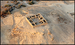
Orhan-Mor lies in the centre of the Arava Valley, north of Nahal Omer. It was established in the third century BC, reached its zenith between the first and third centuries AD, and was abandoned in the first half of the third century AD. It comprises a fort (17 × 17m) that included a square building with an olive press; a caravanserai in the form of a square complex (40 × 40m) with a central courtyard, rooms and a bathhouse; and agricultural terraces and a water pool. Our survey revealed several rubbish middens around the slope of the fort and just beyond the western and northern walls of the caravanserai. Four 1 × 1m test pits were excavated, revealing a series of domestic rubbish accumulations, rich in animal bones, plant remains, livestock dung, small textile fragments, pieces of metal, ceramic sherds and glass fragments (Figure 3; Table 2). The total depth of the archaeological deposits around the caravanserai and on the slope of the fort is approximately 0.3–0.4m.
Aerial view of the Nabataean–Roman (first to third century AD) site of Orhan-Mor and the location of excavations (photograph by R. Galili).

Archaeological characteristics and type of finds recovered from the middens.

The finds are stratified in distinct layers that probably reflect different depositional episodes. The low density of finds in Area D suggests that rubbish was concentrated mainly around the fort and caravanserai. Ceramic chronology and radiocarbon dating show that major accumulation episodes coincided with the peak periods of site occupation. Two radiocarbon dates from the top and bottom of Area C directly overlap with the ceramic evidence, as well as with the known history of the site (see Erickson Gini & Israel Reference Erickson-Gini and Israel2013; Table 3; Figure 4).
Calibrated radiocarbon dates from Orhan-Mor, Neqarot Fort and Sha'ar-Ramon. Dates calibrated in OxCal v4.4.2, using the IntCal20 calibration curve (Bronk Ramsey Reference Bronk Ramsey2020; Reimer et al. Reference Reimer2020).

List of radiocarbon dates from Orhan-Mor, Neqarot and Sha'ar-Ramon, with identification of dated materials and stratigraphic context. Dates calibrated in OxCal v4.4.2, using the IntCal20 calibration curve (Bronk Ramsey Reference Bronk Ramsey2020; Reimer et al. Reference Reimer2020).

The animal bones belonged to several species, mostly sheep and goats (Table 4). In addition, a fragment of a pig mandible and two camel bones were recovered, one of which had been gnawed by a dog. Among the animal remains in Area E we also noted two freshwater crab (Potamon potamios) pincers. This area was also rich in small freshwater snails (Melanopsis praemorsa), indicating the presence of running water, probably via the aqueduct that carried water from the northern spring to the bathhouse inside the caravanserai. The shells, charred material and concentration of ash suggest that the area was used for depositing rubbish from the nearby bathhouse.
Taxonomic composition of faunal remains from the middens.

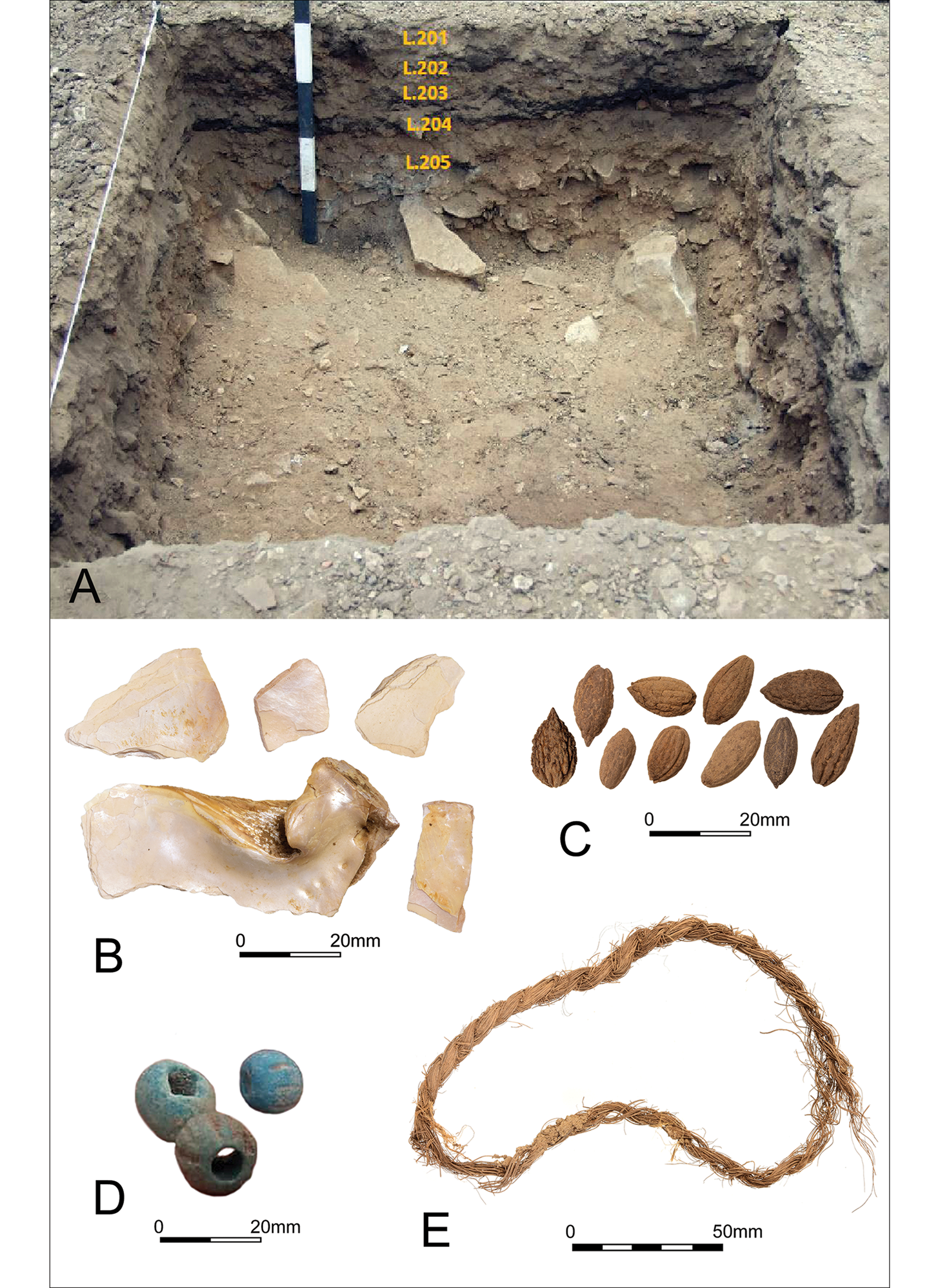
Material from Area C, which was sieved intensively through a 2mm mesh, included the charred remains of the following domesticated plant taxa: barley (Hordeum vulgare), wheat (Triticum sp.), date (Phoenix dactylifera), olive (Olea europaea), grape (Vitis vinifera) and a probable pomegranate (cf. Punica granatum). Barley grains outnumber the date and olive endocarps. Wheat grains are rarer and only a single grape seed was recovered. No plant remains were retrieved from Area D, and the absence of any cereal grains in Areas E and F can be explained by the sieving strategy employed there, using a 5mm mesh only. Area F, however, produced dozens of date endocarps and hundreds of sheep/goat dung pellets, as well as a few olive endocarps (Figure 5).
Section of Orhan-Mor dump in Area F (A) (photograph by Y. Tepper). Finds include Nabataean fineware sherds (B) and date (Phoenix dactylifera) stones (C) (photographs by N. Shamir).

Evidence for the local wild flora comprises predominantly the uncharred seeds and pods of local acacia (Acacia raddiana/tortilis) but also bur clover (Medicago polymorpha) and spiny zilla (Zilla spinosa). The uncharred remains of these species in the upper layers of Area C appear to be recent but their presence throughout the sequence makes it difficult to determine whether this was due to the long-term persistence of local populations or to bioturbation. Evidence for the latter was found in the form of a rodent's nest in this section (locus-basket 314-3403), which contained both charred domesticated plant remains and clearly recent wild remains, such as uncharred Atriplex leaves and the jaw bone of a small reptile. Even accounting for bioturbation, this locus is still the richest sample from Orhan-Mor in terms of domesticated plant variety and probably reflects activity during the peak of the site's occupation.
Neqarot Fort
Neqarot Fort lies on a low hill on the northern bank of a wadi. It was established in the first century AD and was abandoned in the first half of the third century AD. The site comprises a tower with a yard (8 × 7.5m); a ruined rectangular residential complex (17 × 12m); a water pool complex (7 × 7m); and a small (3 × 4m) watch tower on the hill. Outside the two main structures, along the slope of the wadi, we identified two rubbish dumping areas, each measuring a few dozen square metres. Two 1 × 1m test pits were excavated: one south of the Middle Roman fort (second century AD, Area N1) and the other near the Early Roman (first century AD) Nabataean structure (Figure 6; Table 2). The rubbish deposits adjacent to the fort yielded only sparse Roman-period ceramic and glass material. The finds were mixed with modern concrete and construction debris, most probably rubble from conservation work undertaken in the 1990s. No significant ancient rubbish deposits were found in this area. In contrast, a large concentration of such deposits containing numerous pottery sherds was revealed on the fringe of the Nabataean structure (Area N2). These included Nabataean painted ware and imported bowls, lamps, and glass fragments. The pottery chronology is comparable to that found in the residential structure, which dates to the late first century BC and early first century AD. The single radiocarbon date from this area matches the pottery typology and history of the site, covering the range of the pre-Roman annexation phase (Table 3).
Aerial view of the Nabataean–Roman (first to third century AD) site of Neqarot Fort and location of excavations (photograph by R. Galili).

The faunal remains include bones of mostly sheep and goats, and one complete mandible of an adult Dorcas gazelle (Gazella dorcas) (Table 4; Figure 7). Two edible Mediterranean shellfish (Donax trunculus) were also retrieved. Uncharred and clearly recent material dominates the Neqarot plant remains. A few seeds of domesticated plants were recovered, including barley grains, a single wheat grain and fragments of probable olive and date endocarps. All of the domesticated plant seeds are charred. The finds represent the subsistence economy of the site, as well as the cultural influences and trade in goods of both eastern (Nabataean ceramics) and western (glass and Mediterranean shellfish) origins. The overall low concentration of archaeological deposits suggests a short period of occupation and/or a limited population occupying the site.
Finds from Neqarot Fort: A) Nabataean glass vessel; B) gazelle (Gazella dorcas) mandible; C) edible Mediterranean shellfish (Donax trunculus; the black arrow indicates intentional, V-shaped breakage along the margin of the valve) (photographs by N. Shamir).

Sha'ar-Ramon
The site of Sha'ar-Ramon, situated on a hill above a spring, was established in the first century AD, reaching its peak during the first half of the third century AD, before being abandoned soon afterwards. The site was partially re-occupied in the Early Byzantine period (fourth to early fifth century AD). It comprises a caravanserai (42 × 42m) consisting of a square complex, central courtyards, rooms and a cooking facility. We examined an area opposite the main entrance of the caravanserai, where surface finds and dark sediment delineate the ovoid shape of the rubbish middens. Two 1 × 1m test pits were excavated in two areas, which, based on density of finds and colour of sediment, appear to mark the centre of the rubbish dumping area: one at the top of the slope (Area A) and the other in the flat area (Area B) close to the caravanserai gate (Figure 8; Table 2).
Aerial view of the Nabataean–Roman (first to second century AD) site of Sha'ar-Ramon and location of excavations (photograph by R. Galili).

Numerous ceramic and glass fragments were found in both test pits. Each yielded a rich variety of organic finds, including dung, animal bones and a variety of plant remains (Figure 9). The test pit at the top of the slope was excavated to a depth of approximately 1m without reaching the dumping area's base. In the section, we noted two main dark layers containing much ash and charcoal and a lighter layer between them, probably composed of construction debris. The upper dark layer was extremely rich in organic remains, including braids made of palm leaves, date endocarps, charcoal and other plant material, small pieces of textile, and chicken eggshells. Three blue-green faience beads and a small metal ring were found in the lower dark layer. The ceramic finds date the deposits to the first and second centuries AD.
Section of Sha'ar-Ramon dump in Area B (A) (photograph by Y. Tepper). Finds include oysters from the River Nile (Chambardia rubens) (B), olive (Olea europaea) stones (C), faience beads (D) and date-palm (Phoenix dactylifera) cordage (E) (photographs by N. Shamir).
Similar observations were made in the test pit located near the caravanserai gate. The layers were clearly stratified with charcoal-rich lenses, and included fire-cracked stones and pebbles of various sizes, overlying a thin, compacted brown soil. The lower layer was particularly rich with organic matter and contained the remains of a basket and a mat made of palm leaves, as well as abundant animal and plant remains, and ceramic sherds from the first to mid-second century AD. As at Orhan-Mor and Nequarot Fort, the radiocarbon dates overlap with the ceramic dating and with the accepted sequence and history of the site (see Erickson Gini & Israel Reference Erickson-Gini and Israel2013).
The identified animal bones comprise several species, mostly sheep and goats, but also a single camel bone, three fish specimens and a single chicken (Gallus gallus domesticus) bone (Table 4). A fragment of an edible freshwater oyster originating in the River Nile (Chambardia rubens) was also recovered, as was a complete Mediterranean shellfish (D. trunculus), the latter considered an ancient Mediterranean delicacy and documented at other contemporaneous and Byzantine sites in the Negev (Ktalav et al. Reference Ktalav2021).
The Sha'ar-Ramon plant assemblage is relatively diverse, comprising charcoal and uncharred wood, chaff, seeds, stems and windborne seeds. The plant remains can be grouped into three main categories: i) domesticates, including barley, wheat, lentil (Lens culinaris), olive, date, pomegranate and walnut (Juglans regia); ii) local wild flora, comprising acacia, spiny zilla, Salsoleae and colocynth (Citrullus colocynthis); and iii) probable weeds, comprising small-seeded legumes, probable darnel (cf. Lolium) and cleavers (cf. Galium). The domesticates are the best-represented category, particularly barley and olive. Lentil, pomegranate and walnut are each represented by a single specimen. The pomegranate rind and walnut shell were found in the same context (locus-basket 102-1027), underscoring their rarity in the excavated features in general. Although the wheat assemblage is small, both tetraploid and hexaploid wheat are represented by uncharred rachis fragments. It is notable that certain plant parts in the Sha'ar-Ramon assemblage (i.e. grains, legume seeds, date stones) are consistently charred, while others (i.e. zilla fruit, cereal culm nodes, rachis fragments) are uncharred. Olive stones are both charred and uncharred.
The location of the middens and their stratification suggest that they were primary deposits. Fuel waste was probably routinely cleaned from the hearths in the caravanserai and deposited in the midden. Although the dated ceramic material does not enable us to refine the stratigraphy observed, it seems to indicate that the rubbish accumulated during the second and early third centuries AD, which corresponds to the peak occupation phase of the caravanserai. The closest origin of fish would have been the Mediterranean Sea; oysters would have come from the Nile, and faience imported from Egypt.
Discussion
Diversity of finds
The middens along the Nabataean Incense Road have yielded rich and diverse finds. These include the remnants of everyday, commonly used, transportable goods—predominantly sherds of Nabataean pottery, glass fragments, and animal and plant remains. Most ceramics belong to Nabataean painted fineware bowls and other vessels produced at Petra, similar to the complete vessels found in previous excavations at these sites (Erickson-Gini & Israel Reference Erickson-Gini and Israel2013: fig. 32). Nabataean wares are amongst the most useful indicators of the socio-cultural identity of the users of these road stations, and they are also frequently found at the numerous pastoral nomadic sites in the Negev Highlands (described in Rosen Reference Rosen and Politis2007), linking groups from these sites with the commercial system that developed along this part of the Incense Road.
The remains of plants and fruits reveal the main components of the travellers’ diets. Despite the small number of test pits reported, the large quantities and ubiquity of barley grains, as well as date and olive endocarps, attest to these species’ role as Incense Road staples. The relatively high percentage of olives found at Orhan-Mor could be related to the presence of a small oil press found in the fort, dating from the early third century AD. Numerically less significant, wheat grains were nonetheless present at all three investigated sites. Singular finds of lentil, pomegranate, grape and walnut probably represent the occasional consumption of these foods at caravanserais. The absence of fig seeds (nutlets), which are smaller than 2mm, should not be interpreted as evidence for the absence of this fruit but, rather, the result of the minimum sieve mesh size (2mm) we used. Grains and fruits of all the domesticated plants listed above can be preserved and stored for long periods (over a year) and are easily transported over long distances.
The middens were also rich in faunal remains, comprising both livestock, game animals and imported aquatic species. Among the livestock, we identified a small number of sheep and goats, all of which were mature individuals. This reflects the expected pattern of meat provisioning supplied by nomadic pastoral producers (Marom et al. Reference Marom2019) but larger faunal assemblages are needed to support this interpretation. We also recovered a handful of camel bone fragments, some of which had been gnawed by dogs after being discarded. Pigs and chickens were also among the animals exploited for food. Game animals were represented by a gazelle mandible.
Fish and shellfish were represented by several fish vertebrae whose taxonomy and geographic origins could not be identified unequivocally, but which came from a medium-sized marine fish, such as the gilt-head bream (Sparus aurata), which could have originated from either the Mediterranean or the Red Sea. The edible clam shells found at Neqarot and Sha'ar-Ramon were brought from the Mediterranean Sea, while another edible shell from the River Nile was recovered in Sha'ar-Ramon. Both the fish and shellfish remains attest to a high demand for such food and to the sophisticated trade network that facilitated the transport of perishable aquatic products to distant provinces. The trade infrastructure which connected the Red Sea and the Mediterranean Sea is well-documented in the Negev towns and is reflected by an abundance of fish from the Red Sea, the Mediterranean Sea and the River Nile, as well as edible shellfish and Red Sea corals. This complements the observed patterns in the caravanserai middens and shows that the ‘long-distance trade package’ included extensive commerce in aquatic luxury goods that were distributed to the Negev towns (Gambash et al. Reference Gambash, Bar-Oz, Lev and Jeremias2019; Bar-Oz et al. Reference Bar-Oz, Tepper and Shafir2021; Blevis et al. Reference Blevis, Bar-Oz, Tepper and Zohar2021; Ktalav et al. Reference Ktalav2021).
Rubbish discard and disposal behaviour
Most of the excavated midden deposits were found adjacent to walls closest to the main gate of the caravanserai and residential quarters. Rubbish was evidently thrown downhill from the compound slopes in what appears to be a regular pattern of disposal. The size of the middens varied from shallow heaps of up to 2m in diameter to large, ovoid dumps, dozens of metres long, around the sites’ slopes. The larger middens were also characterised by a higher density of finds and were rich in organic remains that were well-preserved by the region's dry climate.
Ceramic and radiocarbon dating for Orhan-Mor and Sha'ar-Ramon indicate that depositional activities extended over the first and second centuries AD, covering both the pre- and post-Roman annexation phases. The date of the Neqarot site corresponds to the earlier, first century AD dates from Sha'ar-Ramon and Orhan-Mor. No significant break in the pattern and composition of deposition was detected at any of the sites, and the dates are in agreement with the evidence obtained from earlier excavations of these sites (Erickson-Gini & Israel Reference Erickson-Gini and Israel2013). The analysis and dating also indicate that the deposition of rubbish near caravanserai ceased in the first half of the third century AD.
Conclusions
Excavation of the middens at Orhan-Mor, Sha'ar-Ramon and Neqarot Fort has shed new light on daily life along the caravan roads of the Incense Route, including on goods transported along them and the subsistence basis of the caravanserai economy. In contrast to previous investigations that have focused on exploring and reconstructing the route and excavating the structures found along it, our research has focused on associated rubbish middens in order to obtain data on the organisation of caravanserai at local and regional scales. We have identified goods and foodstuffs originating from distant cultural spheres, attesting to inter-regional links across the Negev Desert, connecting it into extensive cultural and geographical networks.
Our results indicate that the caravans moving along this section of the Incense Route between Petra and Oboda were self-sufficient and carried with them some of these foodstuffs, as is known from comparable historical networks (e.g. Bar-Oz et al. Reference Bar-Oz2007; Hansen Reference Hansen2012: 9–21; Jianxiong & Cunzhao Reference Jianxiong and Cunzhao2014; Lambourn Reference Lambourn2018). The growth of trade based on caravans was supported by the development of an economic infrastructure that produced additional supplies for the caravanserai of Orhan-Mor and Sha'ar Ramon (within one day's walk of each other) and the main settlements, such as Oboda (three days’ walk from Petra). The detailed analysis of caravanserai middens provides a valuable opportunity to study, in detail, the mechanism of their provisioning.
Shells from the River Nile and the Mediterranean Sea, together with sherds of ceramic vessels produced at Petra, indicate the reciprocal movement of goods along the route, and constitute an extensive corpus of new, high-quality data pertaining to the development of desert trade and the nature of its economy. The diversity of goods presented here offers an original contribution by illustrating the flow of commodities, to show that trade was conducted in both directions, and that it connected distant economic and cultural institutions.
A broader view of these ancient desert routes, based on a multi-national research initiative across the Arabian Peninsula and the Eastern Mediterranean, is required to explore, in detail, the rise and fall of Nabataean commerce. Such a research initiative would more fully bring to light the powerful nature of trade commodities, such as incense resins, spices, silk and other luxury goods, and the routes that their production, transport and consumption followed in antiquity.
Acknowledgements
This work was inspired by the pioneer researchers of the Incense Road in Israel, some of whom shared their knowledge with us. We would like to thank Uzi Avner and Yigal Israel for their contributions and our partners who accompanied the project: Yoav Avni, Avi Blumenkranz, Ron Lavi, Omri Lernau, Dan Malkinson, Rami Reshef, Assaf Sarid, Roee Shafir, Orit Shamir, Naama Sukenik and Catherine Ujma. We are grateful to Ziv Sherzer and his team from Sde Boqer Field School. This study was conducted under a licence from the Israel Antiquities Authority (G-15/2020) and the Israel Nature and Parks Authority (A026-20).
Funding statement
This research received no specific grant from any funding agency or from commercial and not-for-profit sectors.


 Open access