1 Background
After the war of 1939–45 there was a surge of glaciological activity in Britain, and the work on Austerdalsbreen, Norway, in the 1950s was part of that wave of enthusiasm. How did it come about? Gerald Seligman had worked on the Jungfraufirn, in the Swiss Alps, just before the war, and this was the site that Max Perutz chose for his well-known pipe experiment (Gerrard and others, 1952). Perutz arranged for a steel pipe, with its end healed electrically, to melt its way vertically into the glacier down to the rock bed. The inclination of the pipe, at known depths, was measured after it was inserted and again after 1 and 2 years had elapsed. This gave the shear strain, and hence, by integration, the vertical velocity profile; the internal motion of a glacier was being revealed, almost for the first time. The idea of the experiment was not simply to see the velocity profile, but to explain it as a consequence of the viscous properties of ice as measured in the laboratory. John Glen was the research student given the task of measuring those properties, with the result that is known to you all as Glen’s flow law.
Another way of revealing the internal motion of a glacier was to come very shortly afterwards from Vaughan Lewis (Fig. 1), who was also at Cambridge; he was a geomorphologist, in the Geography Department, and had studied corries or cirques, formed by glacial action, in the English Lake District and in the Jotunheimen district of Norway, where they are abundant. He had the notion of driving a tunnel into a small cirque glacier, Veslskautbreen, and so seeing, at first hand, the process of erosion going on at the bed. As good fortune had it, there appeared on the doorstep of the Geography Department at this moment John McCall, who had arrived from Alaska hoping to enrol as a research student. As soon as he heard that a tunnel was required he immediately offered to make it, and that is what he did (McCall, 1952), organising parties of Cambridge undergraduates armed with miners’ picks to do the digging. He was able to mount a theodolite on the terminal moraine pointing straight down the tunnel, and in this way kept it beautifully straight, all the way to the rock bed. He measured the velocity of pegs set in the tunnel walls, and so showed the rotational slip of the glacier over its bed. He also measured the rate of contraction of the tunnel cross-section. In fact, so successful was the operation that he made a second tunnel higher up the glacier as well.
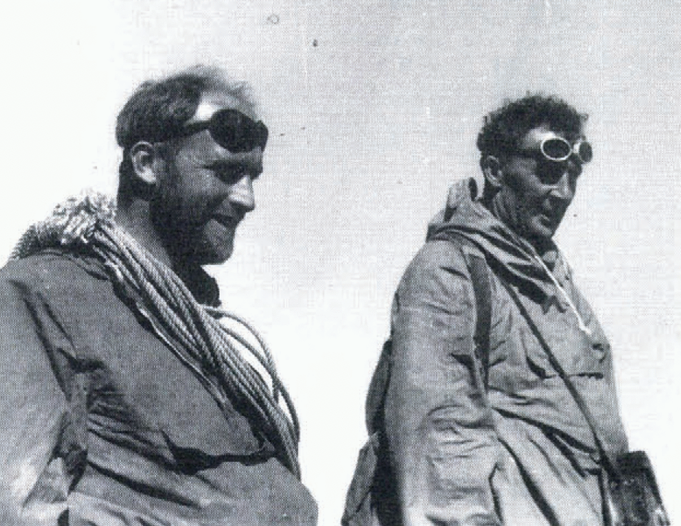
Vaughan Lewis (right) and George de Boer (left) on Austerdalsbreen, 1955.

2 Austerdalsbreen, 1955
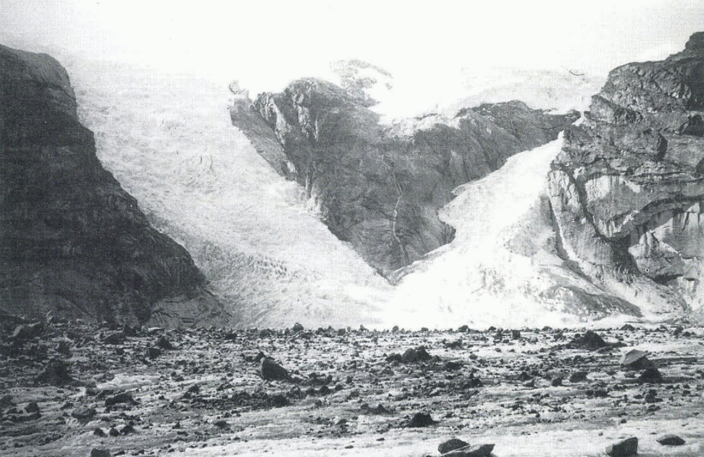
Encouraged by this success, Lewis turned to Austerdalsbreen, one of the outlet glaciers from Jostedalsbreen, which had been drawn to his attention by Bill Ward. It displays two spectacular icefalls, Odinsbreen and Thorsbreen (Fig. 2), and Lewis’s idea was to dig a tunnel at the foot of Odinsbreen that should reach the back wall of the icefall and reveal the erosion processes at work. Once more, the labour force would be willing Cambridge undergraduates. The Brathay Exploration Group had visited the glacier in 1954, had set up painted survey markers on the rock walls and made a very useful map. Also, Bull and Hardy (1956) had made a gravity survey to measure the ice thickness, the first measurement of this kind on any valley glacier. 1955 was the tunnel year, with a base camp in the valley near the glacier snout and a tunnel camp on the glacier itself, set amidst a rock moraine of huge boulders, whose instability caused some concern back in Cambridge. We learned that when you build a rock platform for your tent on a glacier it protects the ice from melting and you live in a world where your surroundings are continually falling. We learned the local rule that you must build the original platform out from the tent an extra 1 m for every week that you plan to stay there; the rocks at the edges of the platform roll away — and, so do you, if you have not done a proper job, and if you are sleeping at the side of the tent. In extreme cases the contents of the tent spill to the edges, and the floor threatens to reach the roof.
As the tunnel went further, water began to accumulate in its far end, in spite of digging initially at a slight uphill gradient. At the foot of the icefall the ice has necessarily to rotate quite fast (about 2° per week) simply to conform with the decreasing gradient of its bed. The floor of the tunnel was lowered near the entrance to allow the water to drain away, and Ward organised an impressive large-scale siphon with the help of a long plastic tube, but these measures merely postponed the inevitable decision to abandon further digging. The tunnel could not be surveyed while digging was in progress, and so it was decided that the last week or so could more profitably be spent in a survey. Glen (1956) did this, measuring both the velocity of pegs in the walls and the rate of contraction of the cross-section. The rotation was clearly seen, and the rate of contraction was compared with what would be expected theoretically if it were assumed that the cross-section was merely responding to the hydrostatic overburden pressure. In fact, the contraction was some 100 times faster than would be calculated on this hypothesis. Glen first took into account that there was, in addition to the overburden pressure, a large longitudinal compressive strain rate in the ice at the foot of the icefall, but this was not enough to explain such a fast contraction (about 6 year−1). He concluded that transient creep was responsible: the ice had not had time, since the tunnel was dug, to reach the quasi-viscous stage of creep
Odinsbreen icefall is on the left and Thorsbreen on the right.
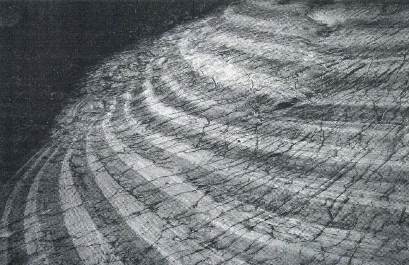
Forbes’ bands on Austerdalsbreen.
3 Austerdalsbreen, 1956
Lewis was above all an enthusiast, and his enthusiasm was infectious. In 1955 he had managed to persuade many scientists to join in: Glen, of course, Ward, Professor Hollingworth of University College London, Cuchlaine King (later Professor of Geography at Nottingham University), George de Boer (Fig. 1), myself and many others. Funding did not seem to be a major problem. Some seven different bodies all made small grants, mainly for travel. I did not see any of the applications, but I think many of them must have been quite informal. There certainly seemed to be no formal written scientific plan for the continuation of the work, except to study the wave ogives and the Forbes’ bands (Fig. 3), which were such prominent features of the glacier tongue. The lack of a plan was very evident in the following year, 1956, when Lewis was ill and unable to continue the organisation. I was spurred on to produce what I thought would be a suitable plan; nobody asked me to do so, and it was never formally adopted, but in fact it became the plan we followed. From this time on, Ward was the field leader of the expeditions, and both Glen and I were very happy with this arrangement.
Our attention was focused on the series of bulges that appeared at the bottom of the icefalls. The currently-accepted explanation was that the ice moved down the ice-fall faster at some times of year than at others, so buckling up the surface into a series of pressure ridges. The plan was to set up a longitudinal line of 22 stakes running across the first four bands (with 11 others to check on the transverse strain rate), and by measuring the changing separations between stakes to see whether that explanation was correct (Nye 1959a, b). This seems rather obvious now, but it should perhaps be said that, while it was common at that time to use stakes to measure velocity, it was not at all common to use them to measure strain rate on a glacier. Ward (1958) designed new hand-drills to make the holes for the stakes (square wooden pegs, 3 m long, in round holes for a tight fit, so that they should not float). We had little idea of the accuracy that would be needed, so we just measured them as accurately as we could. We taped their separations, rebored their holes as they melted out, measured their tilts (to correct for non-verticality), surveyed the positions of certain key slakes by theodolite resection, and measured their relative vertical movements by successive levelling. All this, which was repeated four times over a month (Glen was responsible for the last three surveys), required a great deal of manpower, not only for the surveys but also for back-packing the equipment from the roadhead at Tungasaeter. (We had a helicopter in later years to help carry some of the heavy pipe sections.) At various times in 1956 there were 40–50 people, mostly Cambridge undergraduates, working on the glacier, while parties from the Perse School, Cambridge, and the Brathay Exploration Group brought the total to about 80. We camped mostly at the old tunnel camp-site on the glacier. Much of the food was freeze-dried, supplied free from a Government experimental research station at Aberdeen in exchange for reports on its quality. My wife, Georgiana, organised the commissariat. Somewhat unusually for that time, we mixed the sexes in the camps, and the men students readily accepted orders about backpacking from Leonora Berkeley.
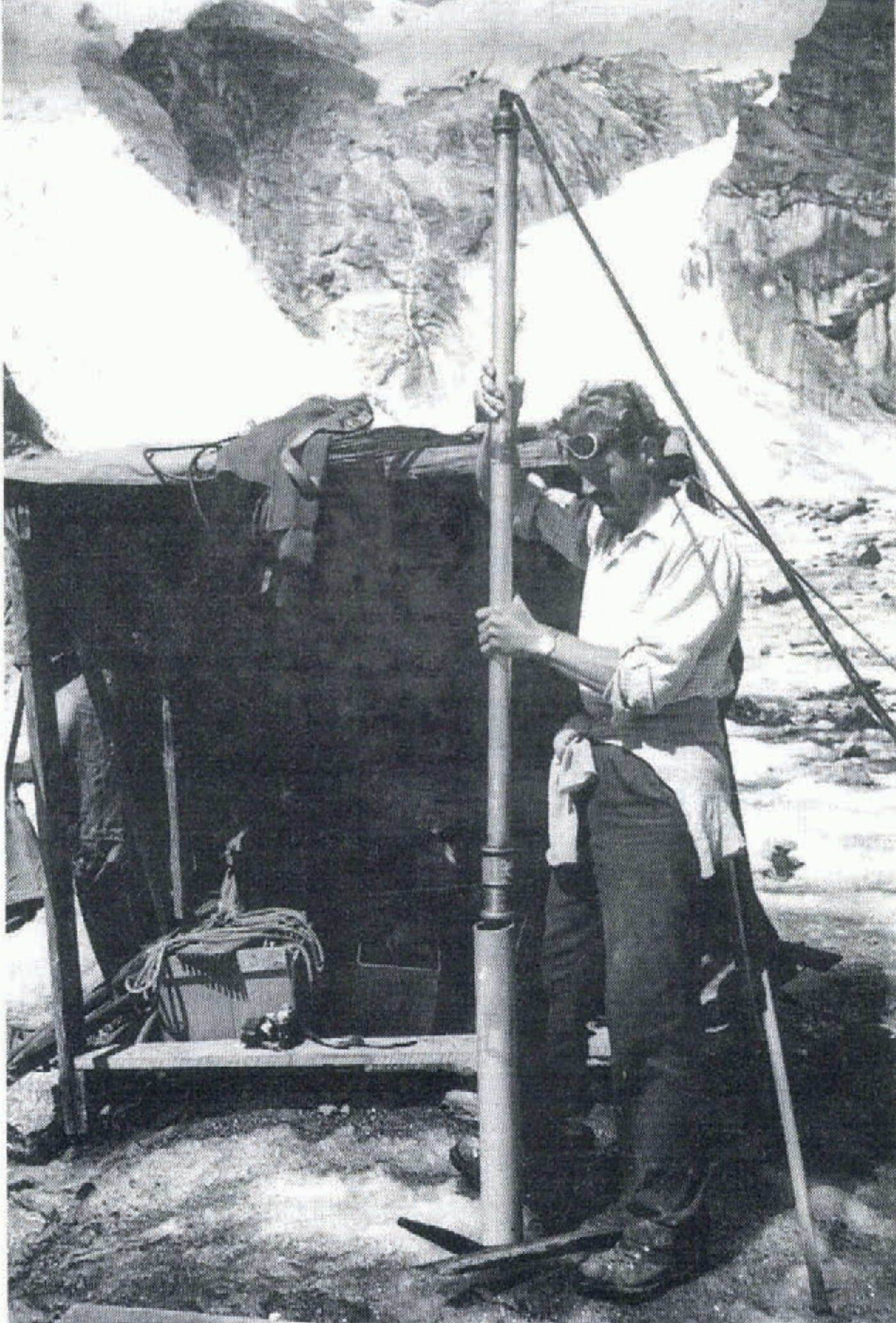
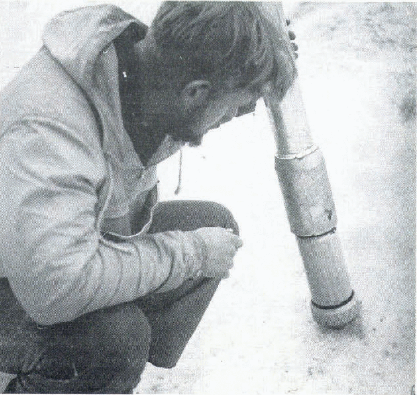
Ward’s main concern was inserting a pipe into the glacier at the foot of the icefall. This came about in a curious way. In 1955 there had been a plan to leave a pipe in the tunnel and survey it with an inclinometer just as Perutz had done, except that this time the pipe would be horizontal instead of vertical. (The plastic pipe that was pressed into service for siphoning was designed for pushing the inclinometer along the pipe.) The need for a vertical pendulum in the inclinometer had dictated that the pipe should have a fairly large diameter; if it had been designed in the first place for vertical use, it would have been much slimmer. The aluminium pipe sections, with screw couplings, were supplied free (with the help of Gerald Seligman), but, in the event, the pipe arrived too late for the 1955 season. The tunnel was never remeasured, because it was lost under an avalanche during the winter of 1955–56. An aluminium ladder and a length of telephone cable, left in it to mark it, only reappeared on the glacier surface, by melting of the avalanche ice, some years later. The tunnel had closed around them completely; the response of the telephone cable when required to compress along its length by force majeure was remarkable; the insulation had broken into separate lengths which had concertinaed; the inner conductor had straight lengths separated by concertinaed sections. Not wanting to waste the pipe, Ward melted it in normal to the surface of the glacier in 1956 (Fig. 4), and it reached a depth of 40 m.
The result of the stake measurements in 1956 was to show that there were indeed oscillations of compressive strain rate across the wave ogives, but, to our surprise, the oscillations bore no relation to the waves; moreover, the crests of the waves showed no signs of rising and the troughs between them showed no signs of falling. It was clear that no pressure mechanism was operating. We needed a different hypothesis.
The three-dimensional velocity measurements on the stakes made it possible to determine the streamlines along which the ice was flowing. These were wavy, reflecting the changing curvature of the glacier bed. The changing curvature, in turn, was bending and unbending the ice throughout its thickness, and this was the reason for the oscillations of compressive strain rate that we had measured. This conclusion was confirmed the following year when we set up a similar stake system in the same absolute position (the 1956 stakes were by then a few hundred metres further down the glacier); the same oscillations of strain rate were seen. They had nothing to do with the wave ogives. So what caused the wave ogives? I had arranged for photographs of the Odinsbre icefall to be taken twice a day from the same spot, using an ordinary folding camera set up on the same rock each time. The prints were later put in register and made into a time-lapse movie (shown at the meeting). But, by superimposing the negatives under a microscope, it was possible to make reasonably accurate measurements of the velocity of the ice in the icefall. This turned out to be far greater than any of us had imagined (reaching 2000 m year−1), with the implication that the ice took only about 1 year to come down the icefall. I was prompted to consider how it would be affected by the seasonal change of ablation rate, and to explain the wave ogives by this effect (Nye, 1958; Waddington, 1986). In short, the high velocity means that any element of ice becomes greatly stretched out while it is in the icefall, and then gets restored to its original length by compression at the bottom. It presents a large surface area while in the icefall and, if it should reside there during the summer, will lose a relatively large volume by ablation. Elements in the icefall during the winter, on the other hand, lose no volume by ablation, because they are covered by snow; these are the ones that form the crests at the foot of the icefall; the summer elements form the troughs. Detailed calculations showed that this mechanism produces crests and troughs in just the observed positions.
Inserting the pipe at the foot of the icefall in 1956.
Lower down the glacier the wave ogives turn into an annual sequence of light and dark bands, Forbes’ bands (Fig. 3). King and Lewis (1961) explained the bands as being ice which had spent either the summer or the winter in the icefall, where the summer, but not the winter, ice was able to collect dirt from the neighbouring snow-free land surfaces.
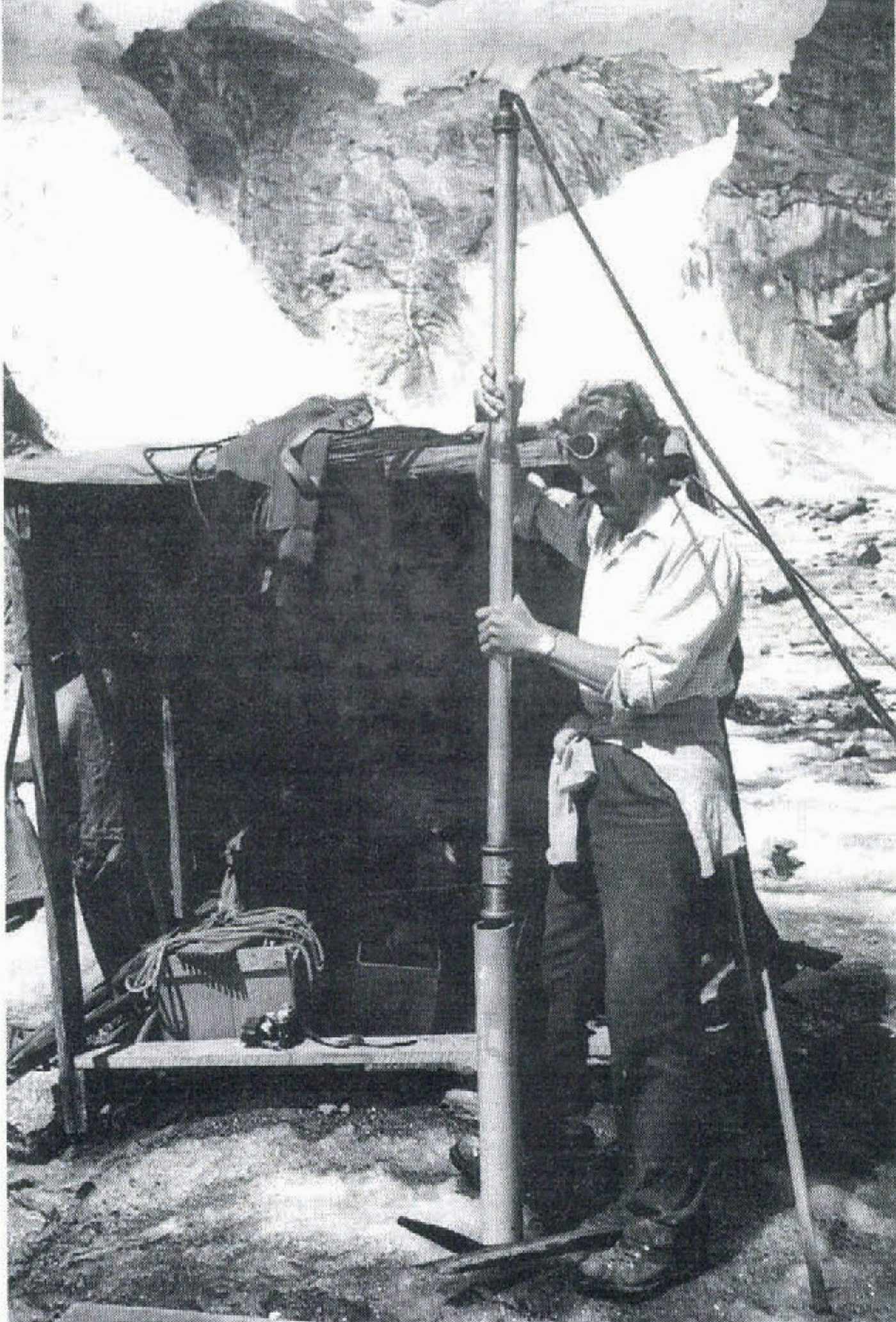
The pipe in the middle section of the glacier. It became filled with ice, through leakage of water, which had frozen by pressure release, and Bill. Ward is here inserting a heated element to melt it out.
4 The Later Years
The insertion of the pipe in 1956 at the foot of the icefall had left some sections over, which were inserted lower down the glacier in 1958 (Fig. 5) (these are the sections that are being-found now near the snout). A new inclinometer was designed, based on the method reputedly used by deep-sea fishermen to discover the run of their cables; they half-fill a jam jar with gelatine and slide it down the cable to a known depth. The gelatine sets, and the angle of its surface provides the necessary information on tilt. The azimuth is obtained by floating a cork furnished with a compass needle on the gelatine surface; this gets fixed into the gelatine as it sets. To adapt this method to the glacier problem the gelatine was replaced by a liquid that froze just above 0°C, and the air above it by another liquid of lower density and higher freezing point. It worked reasonably well.
Work lower down the glacier, mostly in 1957–59, yielded three significant results. First, Glen (1958) and Glen and Lewis (1961) were able to measure the slip velocity of the ice past the rock wall; this was significant because how much, if at all, a glacier slipped at its bed was largely unknown at that time. Secondly, the extreme snout, so far From simply being pushed forward as a rigid wedge, was compressing very fast longitudinally. Glen (1961) measured the longitudinal strain rate very close to the snout and found that even between 3 and 19 m from the end it attained the unexpectedly high value of–0.06 year−1; this was surprising because over most of this gauge length the ice appeared to be in contact with the rock bed. I later gave an explanation (Nye, 1967) in terms of a perfectly plastic model of the mechanics of the snout region. So far as I know, the mechanics in terms of the Glen flow law is still unknown.
The third result was the shape of the velocity distribution along a transverse line. This is usually shown in textbooks as a curve that is convex as seen from the down-glacier side. Our measured curve showed narrow concave sections very near the two sides. These features, which are explained by theory (Nye, 1965), are easily missed by measurement, because they will usually occur in the midst of the lateral moraines. However, they can be established without the use of any instrument other than a pocket ruler, because the curvature of a line of stakes A, B, C can be found simply by sighting from A and measuring the offset between A and the line of BC. The required distances between stakes can be found sufficiently accurately by pacing.
It would be hard to organise a similar expedition today in England. Funding agencies would probably require a much more detailed initial scientific plan (and CVs of all 80 participants?), and students would possibly not be able or willing to put up so much money for their own fares. Some of the young people who took part found careers in glaciology, and it must have been valuable experience for them — as it was for us all.