


Introduction
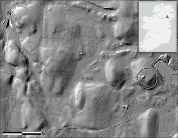
The iconic landscape of Navan Fort is best known for its Iron Age (800 BC–AD 400) archaeology and early medieval (AD 400–1200) literary connections identifying it as one of the five ancient capitals of Ireland (Figure 1). Yet, the significance of this landscape stretches further back in time, at least to the Late Bronze Age (1200–800 BC), when the hillfort known as Haughey’s Fort emerged as a major centre of power. Recent research has advanced our understanding of the scale, complexity and distinctive integration of monumental, domestic and ceremonial elements within this Bronze Age landscape. Drawing on a multimethod approach that includes high-resolution lidar, geophysical surveys, targeted excavations and the reanalysis of key assemblages, this article presents new evidence regarding the character, development and significance of the Navan landscape prior to its Iron Age apogee at Navan Fort. These findings not only redefine interpretations of this important landscape, but contribute to broader debates on social complexity, emergent inequality and proto-urbanism in later prehistoric north-west Europe.
Location and lidar imaging of the Navan landscape, County Armagh, Northern Ireland (figure by authors).

Figure 1 Long description
The main image displays a detailed lidar imaging of the Navan Fort landscape in County Armagh, Northern Ireland. The terrain is marked with various patterns and features, including circular structures and linear formations. The image is oriented with north indicated at the top left corner. A scale bar at the bottom left shows a distance of 0.5 kilometers. The inset in the top right corner shows a map of Ireland with a red dot indicating the location of Navan Fort, situated north of Dublin and west of Belfast.
Bronze Age Navan: a prehistoric centre of excellence
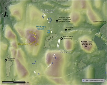
Today, most Bronze Age monuments in the Navan landscape have been entirely levelled, their identification relying on aerial photography and the recording of crop marks (Figure 2). One of the first such sites to be discovered was Haughey’s Fort, a large hillfort comprising three broadly concentric enclosures covering 9.29ha. Excavations in the 1980s–1990s (Mallory Reference Mallory1991; Mallory & Baban Reference Mallory and Baban2014; see also online supplementary material (OSM) Figure S1) revealed that the inner enclosure, at just over 1ha, comprised a stone revetted bank inside a rock-cut V-shaped ditch measuring 3.2m wide and 2.8m deep (Mallory Reference Mallory1991: 13). The middle and outer enclosing elements are broadly similar in size and shape. A large oak fragment from the base of the inner ditch produced a felling date of 1152–1116 BC (Baillie & Brown Reference Baillie and Brown1991: 39–40, Reference Baillie and Brown1998: 45–46). This corresponds closely with radiocarbon dates from short-lived wood in the basal ditch deposit (Figures S2–S5 & Tables S1–S10), placing the initial occupation of the fort around 1191–1018 BC (Mallory Reference Mallory, Waddell and Shee Twohig1995: 75). Comparable dates from short-lived wood and charcoal at the bases of the middle and outer ditches led Mallory (Reference Mallory, Waddell and Shee Twohig1995: 75) to argue that all three ditches were likely built and used concurrently around 1150–1050 BC. The waterlogged conditions of the ditches contributed to the preservation of faunal, wood and ceramic assemblages, which indicate the presence of a large population, either as permanent residents or as seasonal participants in feasting events (Mallory & Baban Reference Mallory and Baban2014: 26).
Record of potential Bronze Age finds and monuments in the Navan landscape before this work was undertaken (figure by authors).

Within the interior, excavations uncovered evidence for intensive contemporaneous activity in the form of pits, postholes and stakeholes, some of which indicate the presence of a large (possibly 30m in diameter) wooden structure near the centre of the hillfort (Mallory Reference Mallory1991: 15–18, Reference Mallory, Waddell and Shee Twohig1995; see also Figures S6 & S7). Several large pits contained substantial amounts of carbonised grain, pottery, fragments of bronze and gold objects, casting debris and waste associated with craft production (Mallory Reference Mallory, Waddell and Shee Twohig1995: 78; Mallory & Baban Reference Mallory and Baban2014: 14; Brandherm Reference Brandherm2014: 59; McClatchie Reference McClatchie2014: 37–39). Brandherm (Reference Brandherm2014: 59) and Warner (Reference Warner2014) suggest that Haughey’s Fort was a regional centre for craft production, including the creation of local copies of imported continental goods (Brandherm Reference Brandherm2014: 62).
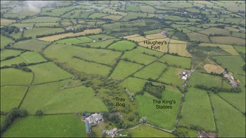
Haughey’s Fort, however, comprises just one part of a broader complex of monuments, with two other notable sites identified nearby: the King’s Stables and the Creeveroe Earthworks (Figures 2 & 3). The King’s Stables is an artificial pool positioned at the north-eastern foot of Haughey’s Fort. Targeted geophysical survey and excavation undertaken by Conway (Reference Conway2006: 40) identified part of an elaborate entrance extending downhill from a break in the outer enclosure of Haughey’s Fort towards the King’s Stables. This comprised a metalled surface flanked on either side by palisades and might infer a deliberate and intimate connection between the two monuments. Limited earlier excavations at the King’s Stables (Lynn Reference Lynn1977) showed that it consists of a flat-bottomed 25m-diameter basin, sunk 4m below the ground surface (and the water table) and enclosed by a penannular bank. Lynn (Reference Lynn1977: 49) argues that the basin filled with water immediately after construction, as evidenced by the rapid accumulation of water-lain organic mud and the exceptional preservation of twigs, branches and other organic material that could only have survived in a permanently waterlogged environment. Unusual deposits, including fragments of moulds for leaf-shaped swords, partly articulated animal remains and a portion of a human skull, suggested to Lynn (Reference Lynn1977) that the site held a ritual function. Radiocarbon dating of the preserved organic material indicates that the site could have been constructed and used contemporaneously with Haughey’s Fort (see Figure S8, Tables S11 & S12).
Aerial photograph, taken in 2023, of Haughey’s Fort and the King’s Stables (photograph by authors).

Approximately 30m to the east of the King’s Stables lies the Creeveroe Earthworks, a pair of levelled, parallel ditches that extend in a roughly north–south orientation and run along the low-lying land at the foot of Haughey’s Fort (Figure 2). Identified in aerial photographs (Hartwell Reference Hartwell1991: 7), these earthworks were initially interpreted as a ceremonial boundary dividing the Late Bronze Age area focused on Haughey’s Fort from the Iron Age sacred core focused on Navan Fort (Conway Reference Conway2006: 38, 152). However, excavations recovered diagnostic Late Bronze Age coarseware pottery from the basal fill of the inner ditch (Conway Reference Conway2006), implying that the earthworks may have been constructed at broadly the same time as Haughey’s Fort and the King’s Stables, challenging earlier interpretations and indicating that they formed part of a complex Late Bronze Age landscape. The significance of the Creeveroe Earthworks is highlighted by the deposition of objects and the construction of burial monuments in its immediate vicinity. A socketed and looped axehead and an imported Iberian-style neck ring were recovered just to the east (Warner Reference Warner2013, Reference Warner2014), while a cluster of levelled burial monuments was identified at the north-east (Hartwell Reference Hartwell1991). At the edge of a bog 500m to the south-west of Haughey’s Fort, a hoard of four objects, known as the Tamlaght Hoard, was discovered in 2004 (Warner Reference Warner2014). This included an imported Fuchsstadt-type bowl (mainly from around northern and south-west Germany, eastern France, southern Denmark and northern Switzerland) and a Jenišovice-type cup (slightly overlapping with the Fuchsstadt-type bowls, this distribution is concentrated in parts of southern Germany, Austria, the Czech Republic, Slovakia and Hungary), the only known examples of these artefact types in Atlantic Europe, along with an imported bronze ring likely from Central Europe (specifically around southern Germany, Czech Republic, Slovakia and north-west Hungary) and a leaf-shaped sword (Warner Reference Warner2014: 21). Among the hundreds of Late Bronze Age swords recorded in Ireland, only four swords of this type have been identified, all located in the north-eastern part of Northern Ireland (Warner Reference Warner2014: 20–21). Warner (Reference Warner2014: 20) proposed that these swords may have been produced locally and, given the strong evidence from Haughey’s Fort and the King’s Stables (where 18 mould fragments for leaf-shaped swords were recovered), it is tempting to suggest that such a workshop was located within this landscape. Regardless, the artefacts within this hoard emphasise the high-status nature of this landscape and suggest that its inhabitants maintained far-reaching connections.
Taken together, the evidence from the Bronze Age landscape surrounding Haughey’s Fort highlights its role as a major centre of power and ritual, revealing the complex and wide-ranging social, ritual, economic and political influence this community exercised at local and regional scales.
The Creeveroe Earthworks: monumentality in a monumental landscape
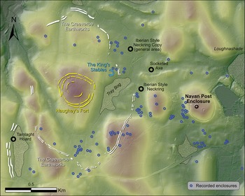
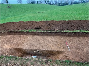
Lidar and gradiometry surveys undertaken by the authors have transformed the scale and course of this monument, redefining its significance (Figures 4, S9 & S10). Rather than representing a monumental division (Conway Reference Conway2006: 37), the earthworks form a large 109ha enclosure encircling Haughey’s Fort. Excavations confirm the presence of two parallel ditches to the south-west of the hillfort, near Tamlaght (Figures 5, S11 & S12). The newly identified extent of this monument means that its enclosing elements do not follow natural contours but instead traverse the hillocks around Haughey’s Fort and, in places, incorporate features such as Tray Bog rather than diverting around them.
Record of potential Bronze Age finds and monuments in the Navan landscape after our work (figure by authors).

Mid-excavation photograph, taken in 2023, of the inner ditch of the Creeveroe Earthworks (photograph by authors).

The Creeveroe Earthworks may now be understood as a large hillfort (namely, the outer enclosure of Haughey’s Fort), making it the third largest known in Ireland or Britain (Figure 4); and the possible presence of a south-western annex encompassing the findspot of the Tamlaght hoard may further increase its overall extent. The largest known hillfort, Spinans Hill 2, in County Wicklow, encloses 131ha and incorporates Brusselstown Ring with its extensive settlement of over 600 likely Late Bronze Age house platforms (Figure S13). On the continent, salient parallels include the 160ha hillfort of Várvölgy–Nagylázhegy, Hungary, where rescue excavations revealed evidence for settlement, grain storage and bronze-working (Müller Reference Müller2006). The sheer scale of such sites has prompted varied interpretations. The 114ha Bindon Hill in Dorset, England, for example, has been viewed variously as an invasion base, assembly site, trading hub and settlement (Hogg Reference Hogg1975: 36). The question of defensibility is continually examined, with Raftery (Reference Raftery1994: 63) doubting the defensive function of Spinans Hill 2 given its size. However, evidence for substantial settlement at both Spinans Hill 2 and Haughey’s Fort/Creeveroe (see below) suggests access to large numbers of people and resources, arguably sufficient to build, maintain and defend a perimeter of this scale if necessary. Palaeoenvironmental analysis identifies substantial landscape clearance around Haughey’s Fort in the Late Bronze Age (Weir Reference Weir1987, Reference Weir, Mallory and Stockman1994), further supporting the presence of a large, thriving settlement (Plunkett Reference Plunkett2006: 65). The enclosing elements of a hillfort could have acted as permanent displays of power, showcasing the scale of resources and people at the disposal of the occupants (O’Driscoll Reference O’Driscoll2018). The incredible scale of the Creeveroe Earthworks, therefore, underscores the site’s far-reaching significance in social, political, economic and ideological terms.
Our geophysical surveys have revealed numerous small enclosures along the periphery of this new 109ha enclosure, many of which likely represent levelled ring-barrows (Figure 4). As ‘landscape monuments’ (Woodward Reference Woodward2000; Cooney Reference Cooney and Cooney2009: 376), barrows played a crucial role in shaping the ritual and social significance of prehistoric landscapes. Their strategic placement around the perimeter of the enclosure, alongside metalwork deposits like the Tamlaght hoard, Iberian-style neck ring and bronze axehead, suggests an intentional effort to enhance the ritual potency of this boundary. These elements may have reinforced territorial claims by invoking ancestral connections, linking past generations to the present and thereby asserting control over land and resources. Similar patterns of spatial organisation and ritual deposition are found at major prehistoric centres across Europe, such as Bel’sk in Ukraine (Makhortykh Reference Makhortykh2013) and the Heuneburg in Germany (Fernández-Götz & Krausse Reference Fernández-Götz and Krausse2012), demonstrating their wider significance in prehistoric societies.
A distinct concentration of larger enclosures is evident on the southern side of the 109ha enclosure, where the enclosing elements notably project outward (Figures 4, S14 & S15). Our geophysical surveys have identified a likely entrance at this location, flanked on either side by two large, now levelled cairns/mounds positioned on two small knolls. The deliberate clustering of burial monuments around the entrance suggests a conscious effort to monumentalise this point of ingress/egress, compelling visitors to pass by the resting places of ancestors, reinforcing the legitimacy, continuity and authority of the community within. Similar strategies of ancestral veneration, territorial assertion and prescribed patterns of movement and approach are well documented at continental hillforts (Fernández-Götz & Krausse Reference Fernández-Götz and Krausse2012: 29) and became deeply embedded in later monumental landscapes (Newman Reference Newman2007: 431).
Haughey’s Fort and the rise of a Bronze Age ‘proto-urban’ centre
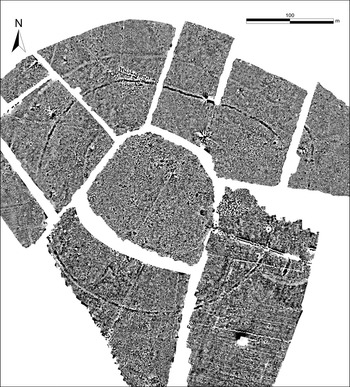
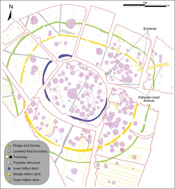
The hillfort of Haughey’s Fort was surveyed using magnetic gradiometry, with multiantenna ground-penetrating radar and earth resistance surveys conducted within the inner enclosure. The results, particularly the gradiometry data, reveal dense archaeological features, including rectangular structures, curving fence lines, large discrete pits and an extensive settlement comprising over 204 anomalies likely representing circular wooden structures (Figures 6, 7, S16 & S17). Most are concentrated within the inner enclosure and in the area immediately outside the north-eastern entrance. Intensive settlement activity was identified in all of Mallory’s excavation trenches, including areas outside the inner enclosure. The structures visible in the geophysical survey likely provide what O’Driscoll (Reference O’Driscoll2023: 39) characterises as a “blurry snapshot of the final phase of use” of Haughey’s Fort, with earlier phases of occupation either obscured or truncated by later activity.
Results of the gradiometry survey of Haughey’s Fort (figure by authors).

Interpretation of the gradiometry data (figure by authors).

Figure 7 Long description
A diagram of a hillfort interior showing various archaeological features and structures. The diagram includes labeled parts such as ridge and furrow, levelled field boundary, trackway, possible structure, inner hillfort ditch, middle hillfort ditch, and outer hillfort ditch. The entrance and a palisade-lined avenue are also marked. The diagram shows the spatial relationships and layout of these features within the hillfort.
Most of these structures measure 7–9m in diameter, a range consistent with contemporaneous Bronze Age house sizes in Ireland (Ginn Reference Ginn2016) (Figures 6 & 7). Three structures are substantially larger, measuring 22, 23 and 30m in diameter (Figures S18 & S19), the latter positioned in the area that Mallory (Reference Mallory, Waddell and Shee Twohig1995) argued, based on excavation evidence, was the location of an exceptionally large structure. Post-like anomalies at the centre of these structures indicate that they may have been large, roofed buildings. Given their substantial size, they are unlikely to have had domestic or craftworking functions. Instead, they may represent ritual/institutional buildings, potentially serving as focal points for communal activities. If so, they would constitute a rare discovery in Bronze Age Ireland or Britain, though an analogous structure has been identified at Glanbane, County Kerry (O’Driscoll Reference O’Driscoll2016: 715–27; see Figures S20–S23).
Without extensive excavation, determining the exact contemporaneity of 204 possible structures remains challenging, although the arrangement of some in rows tentatively suggests they were constructed and occupied simultaneously. The survey results from Haughey’s Fort, therefore, may provide evidence of a possible proto-urban settlement. Recent scholarship has revitalised debates around early urbanism in temperate Europe, challenging traditional views that linked its development to the emergence of the Late Iron Age Oppida (Collis Reference Collis1984). Increasingly, evidence points to earlier phases of urbanisation, particularly in the sixth/fifth centuries BC, with the rise of the Fürstensitze (‘princely seats’, Collis Reference Collis and Fernández-Götz2014; Fernández-Götz et al. Reference Fernández-Götz and Fernández-Götz2014), though O’Driscoll (Reference O’Driscoll2023) argues for an earlier phase of development during the Middle/Late Bronze Age.
Defining ancient ‘urbanism’ is challenging, as concepts such as ‘centralisation’, ‘villages’ and ‘cities’ are subjective, nebulous and frequently conflated under broad or ambiguous umbrella terms (O’Driscoll Reference O’Driscoll2023: 36–38). Scholars have proposed various checklists to identify urban traits (see Kolb Reference Kolb1984; García Sanjuán et al. Reference García Sanjuán2017), though many of these were developed within Mediterranean contexts ill-suited to the wooden architecture and archaeological visibility of temperate Europe (Fernández-Götz et al. Reference Fernández-Götz and Fernández-Götz2014). A more appropriate framework focuses on physical attributes such as settlement size, layout and building diversity, along with elements derived through excavation, such as specialised craft production and/or long-distance trade (Collis Reference Collis and Fernández-Götz2014; Gaydarska Reference Gaydarska2017)—all criteria met at Haughey’s Fort. Indeed, it may have been the stark contrast between large-scale settlements and monumental enclosures, such as Haughey’s Fort, and the more typical dispersed farmsteads that was the truly significant factor.
Although exceptionally rare in both Irish and broader European contexts, large-scale settlements such as Haughey’s Fort are not entirely unique. Excavations at Corrstown, County Derry, uncovered 73 wooden roundhouses arranged around a central metalled road with subsidiary trackways, many of which had been repeatedly rebuilt on the same footprint, indicating a permanent, long-lived settlement dated to the Middle/Late Bronze Age, c. 1370–1250 BC (Ginn & Rathbone Reference Ginn and Rathbone2011). Corrstown is widely regarded as the most compelling evidence for a Bronze Age village in north-western Europe (Brück & Fokkens Reference Brück, Fokkens, Fokkens and Harding2013: 92; Bradley et al. Reference Bradley2016: 187), but several Irish hillforts and unenclosed hilltop settlements may represent much larger proto-urban centres (O’Driscoll Reference O’Driscoll2023). Large concentrations of houses at Knockdhu, County Antrim (Macdonald Reference Macdonald2016; O’Driscoll Reference O’Driscoll2023: 25–28), Mullaghfarna, County Sligo (Bergh Reference Bergh2015: 25–26), Turlough Hill, County Clare (Bergh Reference Bergh2015: 30) and Brusselstown Ring, County Wicklow (O’Driscoll Reference O’Driscoll2023: 18–22), as well as at Fort Harrouard and Catenoy in northern France (Mohen & Bailloud Reference Mohen and Bailloud1987: 138; Mordant Reference Mordant, Fokkens and Harding2013: 579), lowland villages like Malleville-sur-le-Bec (Marcigny & Ghesquière Reference Marcigny, Ghesquiere and Guilaine2008) and the pile-dwelling communities north of the Alps (Mordant Reference Mordant, Fokkens and Harding2013: 579), may suggest that Bronze Age ‘urbanism’ was more widespread across temperate Europe than previously recognised and support the identification of cognate aspects in the complex at Haughey’s Fort.
The settlement record of Bronze Age Ireland is otherwise dominated by individual, isolated farmsteads (Ginn Reference Ginn2016), a pattern mirrored in much of north-west Europe (Brück & Fokkens Reference Brück, Fokkens, Fokkens and Harding2013: 91). These houses are strikingly homogeneous in size and material culture, with little variation to suggest a clear inter-settlement hierarchy, and the absence of large, elaborate structures is particularly notable (Fernández-Götz Reference Fernández-Götz and Fernández-Götz2014: 28).
While some scholars interpret these patterns as evidence for heterarchical or collective organisation supported by large-scale communal monument building (Hamilton & Manley Reference Hamilton and Manley2001: 13; Lock Reference Lock2011), others emphasise hierarchical systems in which elites co-ordinated craft production, long-distance exchange and communal undertakings (O’Driscoll Reference O’Driscoll2023: 4). Continental evidence for high-status burials (Gilman Reference Gilman1981), warrior graves (Cavazzuti et al. Reference Cavazzuti2019) and households incorporating dependent (possible) slaves (Mittnik et al. Reference Mittnik2019), together with widespread use-wear on weapons, prestige goods and hillforts, demonstrates the viability of elite-driven models and suggests that Ireland was at least partially integrated into a broader martial ideology (O’Driscoll Reference O’Driscoll2023: 3–9).
Even so, the Irish evidence invites a broader interpretive frame. Homogeneous settlement forms, the absence of clear site hierarchies and the collective labour implied by large hillforts such as Haughey’s Fort are equally compatible with communal identity formation and shared ritual obligations (O’Driscoll Reference O’Driscoll2018). Here, authority may have been episodic and negotiated, emerging during aggregation, ceremony or inter-household co-ordination rather than resting in permanent elites.
Haughey’s Fort exemplifies this interpretive flexibility. Its extensive domestic settlement, large ceremonial buildings and evidence for specialist production and exchange point to a polycentric organisational landscape in which ritual, economic and residential authority overlapped rather than forming a single hierarchy. Structured deposition at the King’s Stables can emphasise ritual authority as a powerful organising principle, capable of co-ordinating people and practices without necessitating an elite polity. In this light, hybrid systems are plausible: martial reputation and expertise may have conferred influence in some contexts, while communal ritual, kinship obligations and co-operative labour structured others. This perspective accommodates both the pan-European signals of warrior ideology and the locally distinctive traditions of ritual governance and collective monument-making evident in the Navan landscape.
Against this wider backdrop, the data from Haughey’s Fort provide a rich basis for examining the construction and use of a Bronze Age hillfort in Ireland, comprising one of the most comprehensive non-invasive datasets for an Irish hillfort and its immediate environs. Within these vast enclosures, evidence for domestic houses sits alongside much larger, possibly ritual/institutional buildings, while intensive bronze- and gold-working, tied to long-distance trade, further underscores socioeconomic centrality. Our geophysical surveys have revealed areas of concentrated activity suggestive of spatial organisation and controlled craft production, collectively presenting one of the strongest cases for ‘proto-urban’ development in Bronze Age Ireland or Britain. Haughey’s Fort is therefore best understood as a focal place within a developing regional network, where ritual practices, specialised production and exchange combined to create a nucleated hub of power rather than a dispersed settlement pattern.
The King’s Stables: a route to ritual?
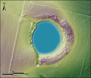
The results of our geophysical surveys indicate that the outer two enclosures of Haughey’s Fort protrude north-east towards the King’s Stables. All three enclosing elements feature an entrance break facing north-east, broadly towards the artificial pool, marking the only known entrance to Haughey’s Fort (Figures 6 & 7). Our analysis indicates that the metalled surface flanked by palisades partly excavated by Conway (Reference Conway2006: 40) formed part of an elaborate 87m-long, 5m-wide, palisade-lined avenue that extends from just inside the entrance of the middle enclosure, through the outer entrance and at least 40m beyond the limits of Haughey’s Fort (Figures S24 & S25). Internally, the feature aligns with the entrance of the inner enclosure, where geophysical survey has identified an elaborate, possibly palisade-lined avenue. This comprises two broadly parallel, linear, positive magnetic anomalies, spaced approximately 4–7m apart and extending for up to 21m, along with a series of pit-like anomalies that may represent individual postholes set within the structure. Externally, the longer avenue runs downhill in the broad direction of the King’s Stables (Figure 8), possibly reinforcing the deliberate spatial and ritual connection between these two sites. Unlike the typically simple gaps or wooden-gated entrances of hillforts elsewhere in Ireland (O’Driscoll Reference O’Driscoll2016: 56–59), the palisade-lined avenue associated with the entrance at Haughey’s Fort displays an unparalleled architectural complexity and was likely designed for ritual purposes.
Lidar survey of the King’s Stables (figure by authors).

Although Lynn’s (Reference Lynn1977) radiocarbon dates offered tentative connections between Haughey’s Fort and the King’s Stables, our new set of dates obtained from archived material, together with the broad architectural alignment of the hillfort enclosures and entrance features, presents substantially stronger evidence that they formed a unified monumental complex (Figures S7, S26 & S27). The new dating also reveals activity around the pool in the seventh–tenth centuries AD, suggesting that first-millennium communities revered the site without re-using it. Early medieval activity is also evident in the upper fills of features within Haughey’s Fort and the Creeveroe Earthworks.
Although closely linked architecturally, Haughey’s Fort and the King’s Stables likely served distinct functions. Excavations at Haughey’s Fort (Mallory Reference Mallory, Waddell and Shee Twohig1995) revealed evidence of bronze- and gold-working, yet no mould or crucible fragments, while limited excavations at the King’s Stables (Lynn Reference Lynn1977: 55) uncovered 18 mould fragments for leaf-shaped swords, but no other production waste. This suggests a spatial (and possibly social) separation between areas of manufacture and ritual deposition. Faunal evidence reinforces this distinction. Haughey’s Fort yielded thousands of bones (Murphy & McCormick Reference Murphy and McCormick1996) indicative of large-scale feasting and domestic occupation, dominated by typical domestic species of cattle, sheep/goat and pig. The King’s Stables, however, produced a highly atypical assemblage (Lynn Reference Lynn1977: 54), dominated by canine remains, red deer antlers and partly articulated pig and canine remains. Most strikingly, while no human remains have yet been found at Haughey’s Fort, the anterior portion of a human skull (Figure 9) and disarticulated ribs were recovered from the pool at the King’s Stables (Lynn Reference Lynn1977: 48). The ritual significance of watery places has been widely acknowledged (Bradley Reference Bradley1990: 102, 107; Brück & Fontijn Reference Brück, Fontijn, Fokkens and Harding2013: 119), but evidence from the King’s Stables reveals a more nuanced ritual landscape, marked by the deliberate deposition of a diverse range of material alongside human remains. The pool’s natural infilling with water may have imbued it with mystical qualities, making it a focal point for ceremonial activity.
Skull fragment deposited within the King’s Stables (figure by authors).

While the King’s Stables is architecturally unique, its pattern of deposition is paralleled at other ritual wetland sites. Locally, this includes the Tamlaght hoard, deliberately placed at the edge of a bog. More broadly, similar practices are evident at Flag Fen, Peterborough (England), where a raised wooden causeway and central platform facilitated the structured deposition of partly articulated animal remains and select artefacts (Pryor Reference Pryor2001). Comparable evidence also comes from caves such as the Sculptor’s Cave, Moray (Scotland), where articulated animal remains and human skull fragments were found near a stagnant pool (Armit & Büster 2022).
The focal ritual and ceremonial relationship between the King’s Stables and Haughey’s Fort is underscored by the palisade-lined avenue linking the two sites, possibly facilitating formal processions. Votive offerings, including valuable artefacts and potential animal or human sacrifices, appear to have been deposited in the pool as part of these rituals. Unique within prehistoric north-west Europe, the site adds significant depth to our understanding of this Late Bronze Age landscape.
Summary
Haughey’s Fort reflects the ambition and organisational capacity of its Late Bronze Age inhabitants. Initially identified from aerial photography as three concentric enclosures, our investigation has revealed a dense complex of archaeological features, including up to 204 possible wooden structures. The presence of large circular buildings, potentially serving ritual/institutional functions, alongside substantial evidence for intensive craft production and long-distance trade, highlights the hillfort’s central role in regional economic and social networks.
The deliberate connection between Haughey’s Fort and the King’s Stables adds an important dimension to understanding this Bronze Age landscape. The metalled, palisade-lined avenue leading downhill from the hillfort broadly toward the pool strongly suggests a formal, likely ceremonial, link between the monuments. While Haughey’s Fort exhibits evidence of craft production, the discovery of mould fragments at the King’s Stables—items notably absent at Haughey’s Fort—points to a specialised function, possibly linked to the ritual deposition or decommissioning of artefacts. The unusual animal bone assemblage at the pool, including articulated remains, aligns with broader traditions in which watery places served as focal points for ritual and possibly sacrificial deposition. The artificial nature of the King’s Stables may reflect a deliberate effort to emulate the veneration of natural water sources, placing the site at a key juncture in longer-term votive traditions. Here, we see specialised ritual architecture that becomes more commonplace through the first millennia BC/AD.
Re-evaluation of the Creeveroe Earthworks, now recognisable as a large 109ha outer enclosure of Haughey’s Fort, places this Bronze Age centre among the largest hillforts in Ireland and Britain. This monumental construction, broadly contemporaneous with activity at both Haughey’s Fort and the King’s Stables, reflects the presence of a highly organised and substantial population. The deliberate placement of burial monuments and metalwork along its perimeter suggests that the enclosure was not merely defensive, but served as a powerful symbol of ancestral authority, community identity and control over land and resources. The clustering of burial monuments around a probable southern entrance further underscores the role of ancestral veneration in shaping movement, access and the assertion of territorial legitimacy.
Conclusion
Long before the nearby Navan Fort rose to prominence in the Iron Age, the emergence of Haughey’s Fort around 1200 BC signalled the foundation of an internationally significant prehistoric complex. Through integrated remote sensing, excavation and archival analysis, our research substantially advances understanding of this Bronze Age landscape, positioning it as a key site for exploring the rise of ‘proto-urbanism’, ritual landscapes and long-distance networks in north-west Europe.
On the nearby hilltop that would later be occupied by Navan Fort, another unusual Late Bronze Age/Early Iron Age monument was constructed, comprising a ditch with an internal line of large posts (Waterman Reference Waterman and Lynn1997: 14–17). Too substantial to represent a domestic structure, it is likely that the monument served a ritual function, pointing to a more complex and expansive Bronze Age landscape, extending well beyond the 109ha hillfort.
Individually, Haughey’s Fort, the King’s Stables and the Creeveroe Earthworks are unique and important monuments. Collectively, they constitute an unparallelled interconnected monumental landscape, serving as a regional hub of power, production and ritual in the Late Bronze Age. The scale and uniqueness of this landscape offer valuable insight into the complexity and influence of Late Bronze Age communities, contributing to our broader understanding of social organisation, economic activity and ritual practice within European prehistory.
Acknowledgements
The authors thank members of HEDoNI for their help and guidance in researching and writing this article.
Funding statement
The authors thank the Royal Irish Academy, who provided funding through the Archaeological Research Grants scheme to undertake geophysical survey at Haughey’s Fort, geophysical survey at the Creeveroe Earthworks and reanalysis of the King’s Stables. We also received funding from the HEDoNI (Historic Environment Division of Northern Ireland) to complete the multiantenna ground penetrating radar surveys; and from the Armagh, Banbridge and Newry Council to excavate at the Creeveroe Earthworks.
Online supplementary material (OSM)
To view supplementary material for this article, please visit https://doi.org/10.15184/aqy.2026.10382 and select the supplementary materials tab.
Author contributions: CRediT categories
James O’Driscoll: Conceptualization-Equal, Data curation-Equal, Formal analysis-Equal, Funding acquisition-Equal, Investigation-Equal, Methodology-Equal, Project administration-Equal, Visualization-Lead, Writing - original draft-Lead, Writing - review & editing-Equal. Patrick Gleeson: Conceptualization-Equal, Data curation-Equal, Formal analysis-Equal, Funding acquisition-Equal, Investigation-Equal, Methodology-Equal, Project administration-Equal, Writing - original draft-Supporting, Writing - review & editing-Equal.


 Open access

