

1. Introduction
The Gardar Igneous Province of South Greenland is the name given to the products of alkaline magmatism associated with continental rifting during the Mesoproterozoic (see Upton et al. Reference Upton, Emeleus, Heaman, Goodenough and Finch2003, Upton Reference Upton2013 for reviews) and represents an exhumed continental rift system. Gardar rocks have remained unmodified in the Greenland crust since emplacement, except for recent glaciation which has carved horizontal and vertical sections through the volcanic systems, dissecting them in three dimensions, and thereby creating one of the world’s great natural laboratories to study rift-related magmatism. The Gardar correlates with alkaline magmatism in the McKenzie Province in North America (Ernst et al. Reference Ernst, Wingate, Buchan and Li2008; Indares Reference Indares2024) and is part of a suite of global magmatic episodes associated with the break-up of the Columbia/Nuna supercontinent (Evans & Mitchell Reference Evans and Mitchell2011). The Gardar comprises dykes (including the so-called Giant Dykes) and central complexes cutting the Archaean and Early Proterozoic basement in a belt stretching from the SW coast of Greenland until it is lost under the inland ice (Fig. 1). Gardar dykes occur on Greenland’s east coast (Bartels et al. Reference Bartels, Nielsen, Lee and Upton2015) and rocks of Gardar appearance are found as clasts in glacial sediments carried from under the inland ice (C. H. Emeleus, pers. comm., 2005; Finch et al. Reference Finch, McCreath, Reekie, Hutchison, Ismaila, Armour-Brown, Andersen and Simonsen2019; our unpublished observations), leading to speculation that Gardar intrusive complexes await discovery under the inland ice, on nunataks or in remote parts of Greenland’s east coast.
Geological map of the Paatusoq Syenite Complex. Smooth flat areas represent regions covered by permanent ice. Inset map modified after Steenfelt et al. (Reference Steenfelt, Kolb and Thrane2016). Main area expanded in the geological map of Paatusoq is identified on the inset map.

Reconnaissance fieldwork in the late 1990s demonstrated that the Paatusoq Complex, hitherto considered part of the Ilua Plutonic Suite (previously called the Rapakivi Granite Suite; Steenfelt et al. Reference Steenfelt, Kolb and Thrane2016) had a zircon U-Pb age (1144 ± 1 Ma) consistent with the final stages of Late Gardar magmatism (M. A. Hamilton, pers. comm., 2001). Petrographic analysis confirmed the presence of an intrusive complex comprising syenite and gabbro. The present study is a description of the Paatusoq region based upon fieldwork, sampling, geochemistry, plus airborne magnetic and radiometric surveys. The exceptional relief at Paatusoq (+2.5 km) provides one of the best dissected subvolcanic systems on Earth; we present field observations and petrography supported by rock, mineral and isotope geochemistry to describe the petrology and petrogenesis of this major Gardar magmatic complex. Finally, we make comparisons with other Gardar complexes to place Paatusoq in the regional context of the evolution of the Gardar rift system.
2. Geological history and context
The South Greenland crust is divided into four geological terranes (Fig. 1) (Garde et al. Reference Garde, Hamilton, Chadwick, Grocott and McCaffrey2002; Upton et al. Reference Upton, Emeleus, Heaman, Goodenough and Finch2003; Vestergaard et al. Reference Vestergaard, Waight, Petersson, Hinchey and Whitehouse2024). To the north is a foreland of Archaean gneisses belonging to the North Atlantic Craton, dated to 3200–2600 Ma (Garde et al. Reference Garde, Grocott and McCaffrey1999, Reference Garde, Hamilton, Chadwick, Grocott and McCaffrey2002). In the Palaeoproterozoic, the edge of the craton was an active Andean margin, the products of which are termed the Ketilidian Orogen. Zones of greenschist-facies metasedimentary and metavolcanic rocks were deposited unconformably upon Archaean basement, termed the Ketilidian Border Zone. To the south of these are Andean-type high-K calc-alkaline I-type granitoids, locally termed the Julianehåb Igneous Complex (formerly the Julianehåb batholith; Garde et al. Reference Garde, Hamilton, Chadwick, Grocott and McCaffrey2002; Steenfelt et al. Reference Steenfelt, Kolb and Thrane2016; Vestergaard et al. Reference Vestergaard, Waight, Petersson, Hinchey and Whitehouse2024) that represent a continental magmatic arc. The Julianehåb Igneous Complex was emplaced in two phases: a volumetrically minor event at around 1850 Ma, and a dominant pulse at 1810–1790 Ma (Vestergaard et al. Reference Vestergaard, Waight, Petersson, Hinchey and Whitehouse2024). Finally, at the southernmost tip of Greenland, the Julianehåb igneous rocks are overlain by Ketilidian metasediments, termed the Pelite and Psammite Zones. These zones comprise variably migmatised clastic sedimentary rocks, volcanic rocks and schists interpreted as part of the forearc and derived from erosion of the Ketilidian hinterland (Garde et al. Reference Garde, Hamilton, Chadwick, Grocott and McCaffrey2002). A suite of granitoids and norite (the Ilua Plutonic Suite, formerly the Rapakivi Granite Suite) intruded these units between 1750–1725 Ma (Garde et al. Reference Garde, Hamilton, Chadwick, Grocott and McCaffrey2002).
During the period 1320–1120 Ma, Greenland was part of the Columbia/Nuna supercontinent and was subject to extension and episodic rifting (Upton & Emeleus Reference Upton and Emeleus1987; Evans & Mitchell Reference Evans and Mitchell2011). Alkaline magmas (the Gardar Province) formed rift volcanoes whose surface expression may have resembled the modern East African Rift Zone. Age determinations, principally through U-Pb and Rb-Sr isotope chronology (cf. Upton et al. Reference Upton, Emeleus, Heaman, Goodenough and Finch2003; Upton Reference Upton2013 and references therein) has divided the province into two tectonomagmatic events, namely the Early and Late Gardar. Early Gardar magmatism spanned from 1320–1260 Ma (Upton et al. Reference Upton, Emeleus, Heaman, Goodenough and Finch2003; Salmon Reference Salmon2013; Upton Reference Upton2013) and now comprises a sequence of rift-related sedimentary and volcanic rocks known as the Eriksfjord Formation, E–W mafic dyke swarms and evolved alkaline complexes including Grønnedal-Ikka (previously spelled Grønnedal-Íka) and the Motzfeldt-North Qooroq (previously spelled Qôroq) Volcanic System (Upton Reference Upton2013; Finch et al. Reference Finch, McCreath, Reekie, Hutchison, Ismaila, Armour-Brown, Andersen and Simonsen2019). Late Gardar magmatism lasted from 1180–1140 Ma, during which time alkaline complexes including Tuttutooq (previously spelled Tugtutôq), Nunarsuit, Klokken and Ilimmaasaq (previously spelled Ilímaussaq) were formed (Upton Reference Upton2013), along with ENE–WSW mafic dyke swarms and two Giant Dyke complexes. The Giant Dyke complexes provide an important link between simple dilational dykes and the alkaline central complexes. Alkaline magmas were emplaced along two parallel rift zones, termed the Nunarsuit-Isortooq (previously spelled Isortôq) (NI) line in the north and the Tuttutooq-Ilimmaasaq-Narsarsuaq (TIN) line in the south ( Fig. 1, inset) (Upton Reference Upton2013). Gardar primary magmas had a spectrum of compositions including carbonatite, lamprophyre (Coulson et al. Reference Coulson, Goodenough, Pearce and Leng2003) and alkali olivine basalt; fractionation of the latter gave rise to augite syenite, nepheline syenite, alkali granite and highly evolved agpaitic rocks (Upton & Emeleus Reference Upton and Emeleus1987). The central complexes are typically layered syenite intrusions which display either silica-undersaturated or silica-oversaturated trends.
Despite its age, the province is essentially undeformed and unmetamorphosed. Following Gardar magmatism, the whole of southern Greenland was isolated from supercontinent-scale deformation events, such as the Grenville orogeny (Upton Reference Upton2013). Recent glaciation has exhumed these structures, often providing three-dimensional slices through the subvolcanic systems.
3. Previous research and mineral exploration in the Paatusoq area
The SE coast of Greenland was identified as a target for regional mapping by Grønlands Geologiske Undersøgelse (Geological Survey of Greenland, now GEUS; Garde et al. Reference Garde, Chadwick, Grocott and Swager1998). For those complexes that were the most difficult to access, such as Paatusoq, mapping comprised remote observations from boats and helicopter, but no landing on Paatusoq was attempted. Paatusoq was assigned at that time to the Ilua Plutonic Suite (Chadwick et al. Reference Chadwick, Garde, Grocott, McCaffrey and Hamilton2000), examples of which are documented along the coast to the north and south. In 1997, a helicopter landing on Paatusoq was achieved and three rock samples were collected. Helicopter reconnaissance defined the structure and extent of the complex more closely (Grocott et al. Reference Grocott, Garde, Chadwick, Cruden and Swager1999; A. A. Garde, pers. comm., 2012). Grocott et al. (Reference Grocott, Garde, Chadwick, Cruden and Swager1999) noted that the structural context of the complex was clearly different from other members of the Ilua Plutonic Suite and an unpublished zircon date has been cited as 1144 ± 1 Ma (U-Pb, M. A. Hamilton, pers. comm., 2001), inconsistent with the Ilua Plutonic Suite but contemporaneous with Late Gardar magmatism (Upton Reference Upton2013). Paatusoq was thereby identified as the only known Gardar Complex located on the coast of SE Greenland. Stream sediments sampled at the mouth of Paatusoq Fjord – probably sourced from the Paatusoq Complex – indicated high rare earth element (REE) and Nb values (Steenfelt Reference Steenfelt2012), which stimulated commercial interest in the area.
In 2007, the Greenlandic mineral exploration company NunaMinerals A/S incorporated Paatusoq into its Hugin licence (historical exploration licence MEL-S 2007-12) and performed a preliminary field assessment. In 2014, NunaMinerals entered an option agreement with Greenland Rare Earth Projects Ltd (GREP) to explore jointly for rare earth elements, Nb, Ta, Zr and U at Paatusoq (NunaMinerals 2014a). NunaMinerals and GREP commissioned EON Geosciences Inc. to carry out a helicopter-borne radiometric survey over Paatusoq in late 2014 (NunaMinerals 2014b,c; Moussaoui & Tessier Reference Moussaoui and Tessier2015). However, NunaMinerals later entered administration and the exploration licence was relinquished. Gardaq A/S, a subsidiary of Amaroq Minerals Ltd, subsequently acquired two mineral exploration licences covering Paatusoq (MEL 2021-11 and MEL 2023-69).
4. Materials and methods
Helicopter-supported fieldwork for the present study was carried out in the summers of 2013 and 2023 supported by NunaMinerals and Amaroq Minerals. The area is remote with substantial (+2.5 km) relief and sampling comprised helicopter reconnaissance and landings, chosen to represent traverses through the complex. It includes both the syenite and gabbro. The area was analysed using satellite imagery to determine targets – the quality of these improved over the course of the study, allowing more detailed reconstructions for fieldwork in 2023. Fieldwork in 2013 focused on a E–W traverse through the centre of the complex, using the most easily accessible outcrops beside Paatusoq Fjord, as well as a vertical traverse from sea level to the top of the 2,168 m summit. In 2023 we targeted the identification of radiometric highs from the geophysical survey. Field descriptions and samples from each landing site were collected, and in 2023 these were supplemented by drone-derived photogrammetric data. Geophysical data available to the present study include a regional airborne magnetic survey flown by the Geological Survey of Greenland (GGU) in 1995 (Rasmussen et al. Reference Rasmussen, Thorning and Tukiainen2013) plus a helicopter-borne radiometric survey acquired in 2014 (Moussaoui & Tessier Reference Moussaoui and Tessier2015). Data are processed and corrected for relief; a full report on the data is presented in the supplementary material, available at https://adrianfinchcouk.wordpress.com/research/the-paatusoq-region-south-east-greenland/. Our geological interpretation (Fig. 1) is the product of combining satellite imagery, field analysis, field photographic panoramas and sampling.
Sample references refer to material in the collection of AAF or Amaroq Minerals Ltd. Petrographic analysis and thin section imaging were carried out using a standard polarised and Keyence VHX-5000 light microscope with a circularly polarising attachment. Geochemical assays were obtained commercially and compared with X-ray fluorescence (XRF) analyses determined in-house. The commercial rock samples were pulped at ActivationLabs, Nuuk, Greenland and transported to ActivationLabs, Ancaster, Canada for analysis. Major and trace element concentrations were determined by inductively coupled plasma optical emission spectroscopy (ICP-OES) and mass spectrometry (ICP-MS) by using a specialist multi-element REE exploration assay package after undergoing a lithium borate fusion according to the method of Hoffman & Dunn (Reference Hoffman, Dunn and Cabri2002). The procedural error for Zr and Y is ±3 ppm based on analyses of standard BIR-1A. Geochemical samples from the Paatusoq Gabbro were also analysed for Au, Pt and Pd using Fire Assay followed by ICP-MS analysis. Fire Assay was carried out at ActivationLabs, Nuuk, Greenland.
All subsequent analytical work, with the exception of the isotopic studies, was carried out at the School of Earth and Environmental Sciences, University of St Andrews, UK. All errors are quoted to 95 % confidence interval. Whole rock geochemical analysis by XRF was obtained on a Spectro X-lab XRF spectrometer system using the methodology of Hoffman & Dunn (Reference Hoffman, Dunn and Cabri2002). The primary X-rays are Rh Kα = 0.6133Å (20.22 keV). Measured standard OU-6 values are within 95 % Si and 99 % for K and Na of certified values. Tungsten values are excluded because of the potential for contamination from crushing in a tungsten carbide mill.
Electron microscopy studies include energy dispersive spectrometry (EDS) to confirm mineral identification and electron probe microanalysis (EPMA) used for quantitative mineral composition. The latter was performed on a Jeol Superprobe JCXA733 (Model 8600) during which beam conditions of 20 nA and 15 kV were maintained. An integral SAMX imager was used to image areas for EDS and wavelength dispersive spectrometry (WDS) analyses following the methodology of Armstrong & Heinrich (Reference Armstrong and Heinrich1991). Quantitative compositional analyses were determined using a SAMX WDS system with a 10 s peak and 5 s background count times. To minimise the influence of element migration, F, Na, Si, Al, Mg were measured first. ZAF corrections were internally calculated by SAMX software.
Zircon crystals from lightly crushed samples of syenite were separated using magnetic separation and LST heavy liquids followed by hand-picking under an optical microscope. The picked zircon grains were mounted onto 1 in polished rounds and imaged by cathodoluminescence (CL) and backscattered electron imaging using a scanning electron microscope systems at the British Geological Survey at Keyworth, Nottinghamshire, UK. The zircon was thereafter analysed by chemical abrasion isotope dilution thermal ionisation mass spectrometry (CA-ID-TIMS) U-Pb methods. Analyses were performed at the Geochronology and Tracers Facility, British Geological Survey at Keyworth, using the ET535 tracer. Further information and analytical data for each method are provided as an online supplement.
5. Results
5.1. Field description, geophysics and petrography
The study area covers a region at the western end of Paatusoq Fjord (60°50′56″N, 43°38′13″E) extending inland onto nunataks within the inland ice (Fig. 1). The area is remote, spectacular and challenging, with much of the geology covered by permanent ice. The target of the present study is a substantial (240 km2) area of syenite and an adjacent smaller (23 km2) gabbro, identified in the geological mapping of Garde et al. (Reference Garde, Chadwick, Grocott and Swager1998, Reference Garde, Hamilton, Chadwick, Grocott and McCaffrey2002) and Grocott et al. (Reference Grocott, Garde, Chadwick, Cruden and Swager1999).
The area is so large (∼300 km2) and has such extreme topographic relief that detailed mapping was unfeasible on the timescales of the present study. The basement is not studied directly but rather we rely on the descriptions of Garde et al. (Reference Garde, Hamilton, Chadwick, Grocott and McCaffrey2002). The local basement around the Paatusoq Complex comprises diorite of the Julianehåb Igneous Complex to the north and west, and high-grade gneissose metasediments of the Ketilidian Pelite Zone to the east (Garde et al. Reference Garde, Hamilton, Chadwick, Grocott and McCaffrey2002). The complex straddles a major NNE–SSW lineament (known as Jokum’s Shear), which marks the boundary between the two basement terranes. Figure 1 and Table 1 summarise our working hypotheses of the overall structure of the Paatusoq Complex, integrating satellite imagery, regional airborne magnetics (AEROMAG 95 data; Rasmussen et al. Reference Rasmussen, Thorning and Tukiainen2013) and a radiometric survey with fieldwork, petrology and geochemical studies (Fig. 3). We use our experience of other Gardar centres to guide us in the present interpretation. Our interpretation is limited, particularly in the south half of the centre, by ice cover and we stress our map is a working hypothesis of the broad structure of the complex. Analysis of satellite images and high-resolution panoramic photography taken in the field frequently hint at further complexity than we are able to resolve within the timeframes of the present study.
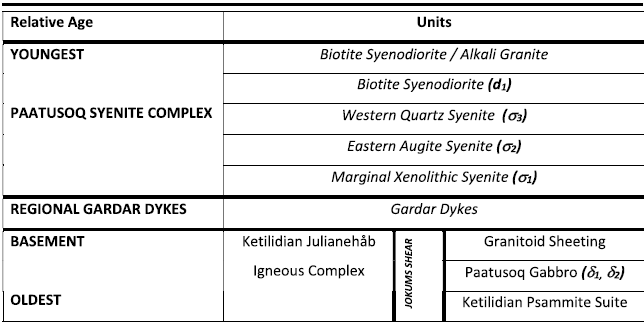
Relative ages of intrusive units in the Paatusoq Centre. Oldest events at the bottom and younger events towards the top.

Views of the Paatusoq Gabbro Centre. (a) Google Earth oblique view from the NW in which the terracing is picked out by snow. (b) Lateral view of a cross-section through layer showing channel structures, cross-bedding and graded beds with lighter bases and darker, more mafic-rich, tops (photograph taken from helicopter fly-past – the vertical field of view is about 10 m). (c) Close-up of a layer with cross-bedding and a light felsic autolith (beneath the hammer for scale). (d) Drone photograph looking down on the SW margin of the gabbro centre, showing terracing within the layered zone at its boundary with the massive unfoliated gabbro (at the top of the photo). Each layer is ∼10 m in thickness.

Geophysical surveys: the scales on all maps are the same. The outline of the complex and internal units from Figure 1 are given.

5.1.1. Paatusoq Gabbro Centre
The region contains a gabbro (area: 24 km2) to the east of the syenite on the south side of Paatusoq Fjord (Fig. 1) which we term the Paatusoq Gabbro Centre. Contacts between the gabbro and other rocks are commonly obscured by permanent ice or the waters of Paatusoq Fjord. The gabbro in hand specimen is characterised by mm- to cm-sized euhedral plagioclase, pyroxene with mm-sized interstitial biotite and amphibole with rounded, altered olivine. The Gabbro Centre has an unlayered marginal facies at the boundaries and a layered zone in the centre (Figs 1, 2d). In the marginal zone, the gabbro is heterogeneous over decametre scales, forming a series of cross-cutting ultrabasic, ultramafic and gabbroic rocks, which include pegmatites with glomeroporphyritic textures and fragmented mafic schlieren. The unlayered marginal gabbro is cut by an inclined leucogranite sheet, comprising quartz, K-feldspar and garnet, with trace pyrite and chalcopyrite. This unit is considered to be Ketilidian in age. The central layered zone is terraced at decametre scales (Fig. 2) in a manner reminiscent of layered basic centres such as the Rùm Igneous Complex, Scotland, UK (Emeleus & Troll Reference Emeleus and Troll2014). The terracing is parallel to layered structures observed in the field. The layering is defined by modal variations in feldspar and mafic minerals, with individual units of augite monzodiorite, olivine gabbro and plagioclase-crystic diorite. The orientation of channel structures and slumps show that the layering sequence is not tectonically overturned (Fig. 2). However, each unit has a sharp base with plagioclase at the base and grades up to a sharp top comprising denser mafic minerals. Since plagioclase is less dense than mafic minerals, the layering is, rather unusually, gravitationally inverted (Fig. 2). Gabbroic and diorite sheets intrude the layered series parallel to the terracing and there are widespread cuspate contacts between gabbroic variants hinting at rheomorphism caused by the intrusion of the inclined sheets. E–W mafic dykes (probably of Gardar age) cut the complex, including a lamprophyre with a sharp chilled contact, comprising fine-grained biotite, hornblende within a groundmass of plagioclase feldspar.
5.1.2. Paatusoq Syenite Complex
Extent and size
The majority of the field area at the head of the Paatusoq Fjord (∼240 km2) comprises the Paatusoq Syenite Complex. Much of the complex is overlain by the eastward calving inland ice sheet but is visible in regional airborne magnetic data as an ovoid magnetic high (Fig. 3). The western margin of the complex is defined by a strong magnetic gradient, although the magnetic signal at the eastern margin is less abrupt. In the field to the east, a sharp, vertical contact between the complex and basement is exhumed on the north side of Paatusoq Fjord. This comprises a zone of large xenoliths, up to several hundred metres in length, preserved close to the margin (Fig. 4c). The eastern margin of the complex is clearly visible in the field and is coincident with a sharp decrease in Th-counts in radiometric data (Fig. 3) and as one moves E–W from basement to syenite on the northern shore of Paatusoq Fjord. The contact with the basement can be followed as it veers E–W and is always vertical.
Views of the Paatusoq Syenite Complex. (a) View across the complex towards the 1,967 m summit in the SW. The contacts between the Paatusoq–Eastern Augite Syenite (σ2), the syenodiorite (d1) and Western Quartz Syenite (σ 3) are visible beneath the peak. Photograph is taken using telephoto from the northern half of the complex. (b) The syenites are cut by late-stage units, some of which are composite. Here the Western Quartz Syenite is cut by an alkali granite showing irregular cuspate margins with the host syenite. This in turn is cut by a mafic-rich rock with biotite and amphibole, that has cuspate contacts against the alkali granite; locally the contacts grade into net-veins. (c) The eastern edge of the complex comprises the Paatusoq–Marginal Xenolithic Syenite which close to the boundary contains cargoes of large pelitic xenoliths. The exposed face is ∼300 m high and the photograph was taken from a helicopter fly-past. (d) Moving W from the complex margin, the xenoliths in the marginal xenolithic syenite become smaller and aligned with the boundary. Many show signs of assimilation, including the large xenolith to the left of the hammer. Glacial striae on the rock surface are highlighted in the sunlight. Hammer shaft is ∼1 m high.

The majority of the complex comprises syenite sensu lato in a series of nested variants. These rocks are dominated by microperthite feldspar with minor interstitial quartz, orthoclase and plagioclase observed in thin section, but rarely identifiable in hand specimen. Feldspar varies in hand specimen from blueish in colour on fresh surfaces (indicative of schiller from cryptoperthite) to white and orange where there is brown staining on feldspar cleavages. The variations in the modal proportions of alkali feldspar, plagioclase and quartz in syenite are difficult to quantify in the field. We infer that the oldest units lie at the margins with progressively younger units moving towards the centre based on geometry and hydrothermal alteration of older units by younger magmatism.
Units within the Paatusoq Syenite Complex
Internal contacts between different syenite units are observed in the field (e.g., Fig. 4). Whereas external contacts are almost always vertical, internal contacts dip steeply towards the W (e.g., Figs 4a, 5). We divide the complex into three main units and a number of minor units. The margin of the complex comprises the Paatusoq–Marginal Xenolithic Syenite (σ1), which is accessible and well exposed in the E of the complex. It is characterised by a substantial cargo of altered angular to subangular metapelite and metagabbroic xenoliths. In the E, xenoliths comprise local basement and consistently have long axes parallel to the southeast margin of the complex (30°/120). The largest and densest accumulation of xenoliths occurs near to the margin of the complex in a 500 m wide zone (Fig. 4c). At 1 km from the contact, xenoliths are smaller (generally <1 m) showing signs of anatexis and resorption (Fig. 4d). Pelitic xenoliths show evidence for both regional (Ketilidian) and thermal (Gardar) metamorphism, being dominated by biotite with thermal spinel and corundum; metagabbro xenoliths (presumably sourced from the Paatusoq Gabbro Centre) have inverted thermal pigeonite (Fig. 6a). The Marginal Xenolithic Syenite is traced parallel with the eastern margin of the complex, with spectacular exposure in mountains to the N of Paatusoq Fjord (Fig. 4c). It also extends to the S but is lost under permanent ice and its extent could not be confidently determined. In thin section, the syenite is predominantly microperthite, but with smaller granular plagioclase, orthoclase and interstitial granophyre (i.e., a vermicular intergrowth of quartz and K-feldspar).
Composite of the eastern face of the 2,168 m summit looking to the W. (a) Shows a suite of sub-horizontal alkali granite sheet-like bodies that have irregular contacts with the surrounding syenite. In some regions the unit appears strongly cross-cutting; towards the bottom right of the view there are a network of veins. (b) Shows the inclined contact between the marginal xenolithic syenite (right, σ1) and the eastern augite syenite (left, σ2), marked by a dotted line and annotated in the inset. (c) Shows a series of vertical sheets exhibiting textures interpreted as rheomorphism, mingling and mixing with the syenite. Photographs taken from helicopter fly-past.

(a) Gabbroic xenoliths in the syenite have inverted thermal pigeonite (Pig) (sample: AF-13-04). (b) Hydrothermal alteration creates mantles of sodic amphibole (Amph) around the augite pyroxene (Px) and alteration to iron oxides (Fe oxide) (sample: AF-13-10). (c) The majority of the syenites are microperthite, but discrete crystals of orthoclase and sodic plagioclase are commonly developed in veinlets and interstitial regions, indicating a transsolvus feldspar evolution (sample: AF-13-10). (d) Augite pyroxene has Na-rich green amphibole at margins and trellis-type exsolution of magnetite along cleavage planes (sample: AF-13-18). Width of field of view in all images is 4 mm.

Xenolith-rich leucocratic rocks, reminiscent of the Marginal Xenolithic Syenite, are also observed on nunataks in the NW. Here, felsic-rich magma surrounds and penetrates dark basic rafts in a zone parallel to the western margin; however, these dark rocks are not local granite-gneiss basement. The region is notable as complex areas in K, Th and U radiometric surveys with locally high responses (Fig. 3). There are two hypotheses to interpret the presence of basic rocks in this region. First, these may be dismembered fragments of another Ketilidian gabbro, consanguineous with the Paatusoq Gabbro Centre, lying at the western margin of the syenite, which has been intruded and brecciated by the younger magma. However, an alternative interpretation, consistent with observations at other Gardar centres (e.g., Finch et al. Reference Finch, McCreath, Reekie, Hutchison, Ismaila, Armour-Brown, Andersen and Simonsen2019), is that this is a collapsed roof zone of basalt lava from higher stratigraphic levels. An unconformity between basement and basalts lava is observed in situ a few km to the N as the Sorte Nunataq Group supracrustal sequence (Garde et al. Reference Garde, Hamilton, Chadwick, Grocott and McCaffrey2002). The terrain was too extreme for a helicopter landing on the nunatak and hence we are unable to conclude more about this region.
Ice cover across the south of the Paatusoq Gabbro Centre precludes determination of whether the Marginal Xenolithic Syenite skirts the whole complex or comprises a number of separate but broadly similar units. We present the simplest interpretation in Figure 1 and show the Marginal Xenolithic Syenite as a single, continuous unit. There is petrographic variation within the Marginal Xenolithic Syenite. Generally, further from the outermost contacts of the centre, the unit contains progressively less quartz and granophyre. Modal layering was observed in one area in the western section of this unit, dipping shallowly (30°) towards the centre of the complex, with channel structures up to 3 m in depth. The layering is defined by variations in the relative proportions of feldspar and mafic minerals, which are abundant and euhedral in the mafic-rich regions grading to less frequent, interstitial mafics between alkali feldspar in the syenite. When in contact with younger units, Marginal Xenolithic Syenite sometimes develops a striking orange colour in hand specimen from the replacement of olivine and augite by iron-rich clays and oxides (Fig. 6b), often precipitated on the cleavage surfaces of white microperthite feldspar. The contact of the marginal syenite with younger rocks to the W is visible in the face of 2,168 m summit (Fig. 5) and can be traced southward as a region of orange hydrothermally altered syenite. The contact in the western part of the unit is visible on the N side of Paatusoq Fjord.
Within the Marginal Xenolithic Syenite is the Paatusoq–Eastern Augite Syenite (σ2). A sharp inclined contact with the Marginal Xenolithic Syenite is visible beneath the 2,168 m summit (Fig. 5) and is traced in the K-radiometric survey (Fig. 3). The Eastern Augite Syenite is darker in outcrop that the Marginal Xenolithic Syenite to the E, less altered in hand specimen, lacking the striking orange colouration and we therefore infer that it is younger than the Marginal Xenolithic Syenite to the E. We also infer that the orange staining in the older unit results from fluids exiting the Eastern Augite Syenite. The Eastern Augite Syenite comprises euhedral alkali feldspar with interstitial mafic minerals and few other minerals visible. In thin section, feldspar is predominantly patch and vein microperthite with finer separate crystals of plagioclase and orthoclase in interstitial regions. The mafic grains are interstitial aegirine-augite pyroxene, commonly with rims of brown or brown-green amphibole. Prominent cleavages are continuous from the pyroxene core to the amphibole rim, indicating that the amphibole is late magmatic or subsolidus. In some samples, the mafic minerals are predominantly amphibole (possibly magmatic) with few relict pyroxene cores. Early formed apatite occurs as fine needles in both feldspar and mafic minerals.
To the W is the Paatusoq–Western Quartz Syenite (σ3). This unit includes some of the highest relief in the complex and has locally strong K-, Th- and U-radiometric responses. Petrographically, it comprises euhedral alkali feldspar with interstitial mafic minerals, quartz and granophyre. The western contact with the Marginal Xenolithic Syenite is visible on the north side of Paatusoq Fjord. The contact between the Eastern Augite Syenite and the Western Quartz Syenite is exploited south of Paatusoq Fjord by a series of inclined sheets of syenodiorite.
The three main intrusive units of the Paatusoq Complex are cut by syenite pegmatite and other minor intrusive bodies. A dark inclined sheet, ∼300 m thick, is visible in the S side of Paatusoq Fjord intruded along the contact between the Eastern Augite Syenite and the Western Quartz Syenite. The petrography of this unit is notably more mafic-rich and we refer to this as Paatusoq–Biotite Syenodiorite (d1). This contains euhedral plagioclase, quartz and alkali feldspar with amphibole, aligned biotite laths and rare olivine. Elsewhere in fjord walls are shallowly inclined leucocratic sheets of Paatusoq–Alkali Granite, ∼1–5 m thick, cutting all syenite units (Fig. 1). The alkali granite corresponds to radiometric highs in K, U and Th (Fig. 3) which we attribute to higher concentrations of K-feldspar and zircon in this unit. Some alkali granite shows sharp, planar contacts with the host syenite whereas other contacts are notably vein-like and irregular, such as that in the face of the 2,168 m summit (Fig. 5). The alkali granite also forms composite sheets with a biotite syenodiorite with irregular cuspate contacts between granite and syenodiorite indicative of magma mingling (Fig. 4b). Pegmatitic quartz syenite variants are observed, dominated by quartz, alkali feldspar with radial acicular pyroxene and arfvedsonite prisms.
5.2. Petrography
5.2.1. Paatusoq Gabbro
In thin section, the Paatusoq Gabbro comprises different modal proportions of pyroxene (both clino- and orthopyroxene), mm-sized olivine and plagioclase with an equant opaque (titanomagnetite) and accessory apatite ± orthoclase feldspar. The gabbro is texturally highly variable going from ultramafic units dominated by interlocking mafic minerals to gabbro with euhedral plagioclase and interstitial pyroxene. Mafic minerals are often altered: some pyroxene is replaced by amphibole and/or clusters of biotite and chlorite; olivine is wholly or partly replaced by fine-grained ferric hydroxides. Clinopyroxene also contains oriented inclusions of opaques and brown secondary minerals (possibly mica) parallel to cleavage. The unit was described by Grocott et al. (Reference Grocott, Garde, Chadwick, Cruden and Swager1999) as ‘monzonorite’ and ‘monzogabbro’; both terms conform with gabbroic variants observed in the present study.
5.2.2. Paatusoq Syenite
All Paatusoq syenites are dominated by alkali feldspar in vein and patch microperthite forms with occasional cryptoperthite relicts. In thin section, the change in the colour of the hand specimen from blueish to white to orange correlates to increased turbidity in feldspar and changes in alkali feldspar intergrowth state. The darkest feldspar in hand specimen contains cryptoperthite (dark, with locally a bottle-green tinge) grading to microperthite (white). The Western Quartz and Eastern Augite Syenites show an unusual coexistence of microperthite with interstitial, granular crystals of discreet K-feldspar (orthoclase) and plagioclase which sometimes join to form veins (Fig. 6c). Adjacent to some microperthite, replacement of mafic minerals (particularly olivine) results in brown replacement products, inferred to be mixtures of Fe-rich hydroxides and clay (Fig. 6b), which penetrate along feldspar cleavage planes. Interstitial granophyre is observed in the Marginal Xenolithic Syenite and the Western Quartz Syenite, but is absent from the Eastern Augite Syenite between. We observe an evolution from E to W in the mafic mineralogy with augite surrounding altered olivine and opaques in the Marginal Xenolithic Syenite in the east, grading to pyroxene, amphibole, biotite and free quartz in the Western Quartz Syenite. Many pyroxene crystals, particularly at higher levels, show fine orthopyroxene exsolution lamellae but these are often obscured by magnetite in ‘trellis’ structures which have formed within the pyroxene parallel to cleavage (Fig. 6d). Brown amphibole is observed in close proximity to pyroxene, often rimming the edges (Fig. 6b). Very fine selvages of green amphibole and green pyroxene, inferred to be Na-rich, are observed, indicative of multiple generations of amphibole growth (Fig. 6b).
5.3. Geochemistry
The major element geochemistry of the Paatusoq samples (both syenite and gabbro centres) is presented in the supplementary data. A total alkalis versus silica (TAS) discrimination diagram is presented in Figure 7. The Paatusoq Gabbro plots in the sub-alkaline gabbro-diorite fields from 2–7 wt% total alkalis; the data are consistent with a liquid line of descent from ultramafic rocks through gabbro to a leucocratic gabbroic rock that plots in the syeno-diorite field. The granitic sheet that cuts the gabbro is strongly acidic.
Total alkalis versus silica diagram with fields from Cox et al. (Reference Cox, Bell and Pankhurst1979). Ketilidian units (including the Paatusoq Gabbro Centre) are shown as squares whereas units of the Gardar Paatusoq Syenite Complex are shown as circles. The curved line is the alkalic/sub-alkalic boundary. The Paatusoq Gabbro has a range of compositions from ultramafic to syenodiorite. The dashed lines are modelled fractionation curves for a primitive melt at a variety of pressures (0.1, 0.4, 0.5 GPa, Soderman et al. Reference Soderman, Weller, Beard, Riel, Green and Holland2025).

The rocks of the Paatusoq Syenite Complex define a coherent trend that runs from syenodiorite through to alkali granite (Fig. 7). The majority of samples from the three main syenite units cluster in the syenite field (57–62 wt% SiO2 and 9–12 wt% total alkalis) with each unit slightly more silicic than its predecessor. The late-stage residua (alkali granite and syenodiorite) are the most and least siliceous compositions within the Paatusoq Syenite Complex, respectively. Figure 7 also shows the modelled fractionation curves for a primitive Gardar melt at a variety of pressures (0.1, 0.4 and 0.5 GPa) calculated by Soderman et al. (Reference Soderman, Weller, Beard, Riel, Green and Holland2025). The compositional range at Paatusoq is consistent with their fractionation model at 0.4 GPa but inconsistent with fractionation at deeper and shallower levels.
Trace elements of primitive magmas have been used widely to fingerprint magma sources; however, with evolved systems, such as Paatusoq, source signatures are modified by fractionation and crustal contamination during magma ascent and emplacement. The radiometric surveys (Fig. 3) show that pelitic country rocks are richer in Th than the syenite, hence the syenite may be significantly modified by local crustal contamination. Thorium concentrations in the syenite typically range from 2–8 ppm although occasional high values (up to 30 ppm) are identified. The spatial distribution of Th from radiometry shows regions of high Th parallel to the contact in the Marginal Xenolithic Syenite, where xenoliths are observed in the field (Fig. 4c), and this is consistent with Th acting as a proxy for local crustal contamination. We infer that high-Th anomalies unaccompanied by increases in K identify digested country rock xenoliths. Uranium concentrations are all low and variable.
5.4. Geochronology
Zircon from two samples of syenite are analysed to determine their U-Pb isotopic compositions and to constrain the age of the syenite magmatism. The samples were chosen to represent what are from field evidence the earliest and latest magmatism in the Paatusoq Syenite Complex. The hand-picked zircon grains commonly display oscillatory zoning in backscattered electron and CL imaging. Zonation patterns vary from relatively simple to complex with multiple nuclei and reprecipitated margins highlighted by a bright CL response (refer to the supplementary material for details of methodology and textural observations). The zircon CL patterns from both samples did not show significant evidence of subsolidus replacement (cf. McCreath et al. Reference McCreath, Finch, Simonsen, Donaldson and Armour-Brown2012). Samples close to the easternmost margin of the complex were excluded from the study to minimise the possibility of xenocrystic contamination from country rocks. A detailed analysis of age interpretations is presented in the supplementary material and the best estimates are reported in Table 2. Data are predominantly concordant, and both 206Pb/238U (Th corrected) and 207Pb/206Pb (Th corrected) are calculated to permit direct comparison with published data sets that rely on upper intercept regressions of U-Pb data or are reported as 207Pb/206Pb (Th corrected) dates. Age estimates from both the 206Pb/238U and 207Pb/206Pb systems provide similar dates and age interpretations, consistent with a young Gardar age. The 207Pb/206Pb ages are marginally older (Table 2) due to the recognised discrepancies between λ238U and λ235U (Schoene et al. Reference Schoene, Crowley, Condon, Schmitz and Bowring2006). The emplacement durations of the magmatic complex identified by both isotopic systems agree and indicate the complex is the product of a short-lived magmatic event emplaced over a period not exceeding 1 Ma. This is constrained by preferred 206Pb/238U (Th corrected) age interpretations, which yield a duration of 0.48 ± 0.39 Ma defined by dates in alignment with the relative chronology and intrusive history. No age estimates on the Paatusoq Gabbro Centre have been attempted.
CA-ID-TIMS U-Pb age determinations of units in the Paatusoq Syenite Complex. Samples were annealed and chemically abraded before isotope analysis. Ages are given in Ma; precisions are in the form ±x/y/z where x = analytical uncertainty for comparison within this study and with other studies utilising the ET535 tracer; y = the uncertainty including tracer calibration for comparison with U-Pb data derived from a different tracer; z = total uncertainty including decay constants for comparison with other decay systems.

6. Discussion
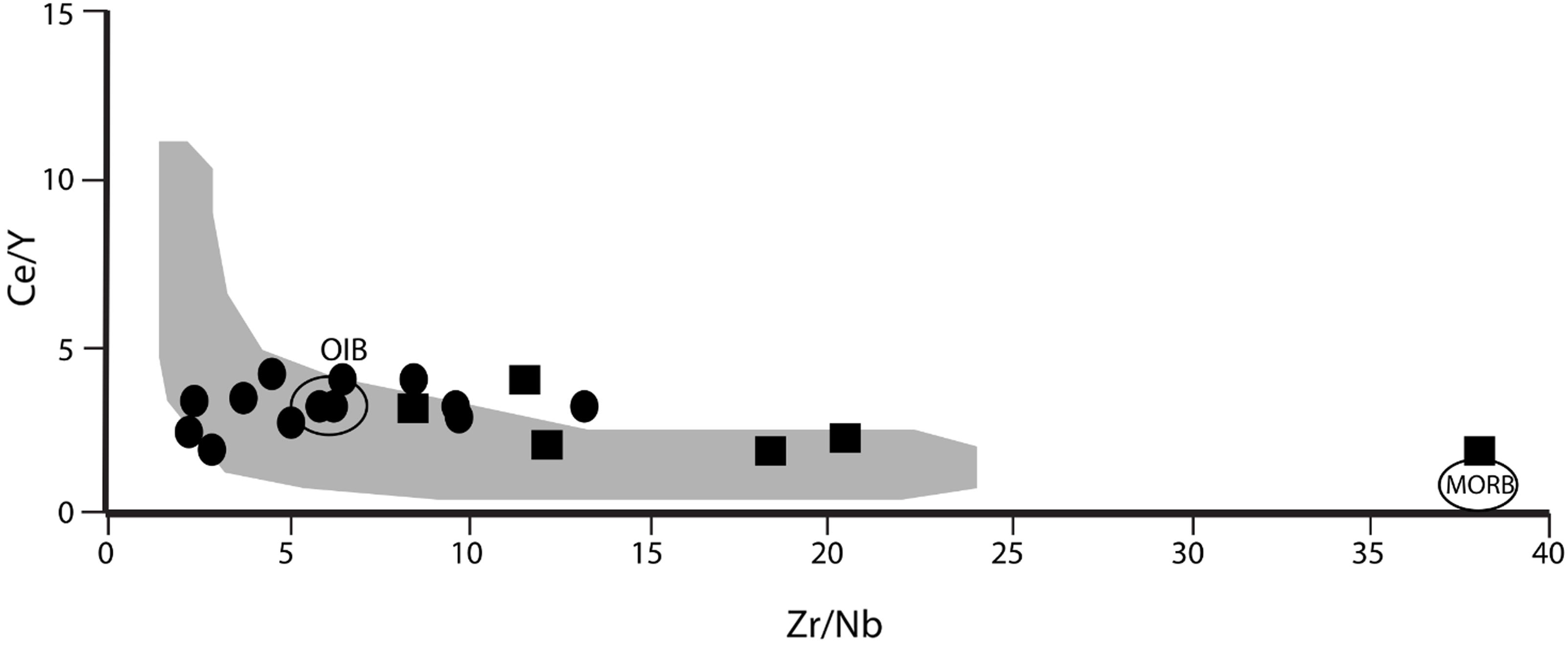
Incompatible element ratios are probes of mantle source (e.g., Cox et al. Reference Cox, Bell and Pankhurst1979) and Figure 8 presents Ce/Y versus Zr/Nb for the rocks of the Paatusoq region. These discriminators indicate the Paatusoq Gabbro derives from a mantle that mixes mid-ocean ridge basalt (MORB) and ocean island basalt-like (OIB) components, consistent with a subduction-related origin. Our field observations show the Paatusoq Gabbro to be cross-cut by a garnet leucogranite sheet, thereby confirming the suggestion of Grocott et al. (Reference Grocott, Garde, Chadwick, Cruden and Swager1999) that the gabbro is a Ketilidian-age complex. We consider the Paatusoq Gabbro Centre as part of the Ilua Plutonic Suite, consanguineous with layered norite elsewhere in the region, notably the Stendalen Intrusion, 30 km to the south (Stendal et al. Reference Stendal, Mueller, Birkedal, Hansen and Ostergaard1997; Sørensen et al. Reference Sørensen, Weatherley, Kokfelt and Nielsen2016). The Ilua Plutonic Suite was emplaced 1750–1725 Ma (Garde et al. Reference Garde, Hamilton, Chadwick, Grocott and McCaffrey2002) and we infer that the Paatusoq Gabbro Centre is of an equivalent age. The Paatusoq Gabbro is highly texturally variable – sub-planar, decametre-scale variability is related to the layered nature of the centre, and we interpret the textural complexity in the west, close to the contact with the syenite, as the result of interaction between the Paatusoq Syenite Complex and the gabbro. Thermal modification of the gabbro and hydrothermal alteration may have resulted from proximity to the Paatusoq Syenite Complex. Some layered mafic-ultramafic intrusions are targets for platinum group elements and gold, but fire assay of Paatusoq Gabbro rocks showed precious metal contents (Au, Pd, Pt) ranged only between the limit of detection and 50 ppb (see the supplementary material). Vanadium and titanium ranged from 70–730 ppm and 0.5–5 % respectively with a very strong correlation (R 2 = 0.98) in the majority of samples, consistent with these elements hosted in magnetite solid solution with coulsonite and ulvöspinel components. The two highest Ti samples (Ti ∼5 %) did not correlate with V, supporting that the Ti was present in another phase in those rocks. Although the majority of the complex remains unexplored, Ti and V grades observed in our samples are low compared to Stendalen (which has been identified as having commercial Ti and V potential, Hughes Reference Hughes2016) and with other Ti-V exploration targets in Greenland (Sørensen et al. Reference Sørensen, Weatherley, Kokfelt and Nielsen2016).
Ce/Y versus Zr/Nb for the Paatusoq region. The Paatusoq Gabbro Centre (squares) has higher Zr/Nb plotting towards a MORB source, consistent with Ketilidian geochemistry. The Paatusoq Syenite Complex (circles) overlap with the grey field, which is a compilation of primitive Late Gardar dykes from across Southern Greenland (Hutchison et al. Reference Hutchison, Finch, Borst, Marks, Upton, Zerkle, Stüeken and Boyce2021). One high Ce/Y sample (Ce/Y >20, not plotted) is hydrothermally altered.

The gravitationally inverted layering in the gabbro, with lower density plagioclase at the base and denser mafic phases at the top, is rare. Such layering may result from intrusion of magma sheets of different compositions parallel to the fabric of the macroscopic layering with magma mixing at the interfaces. However inversely graded macrorhythmic modal layering formed in situ is also reported from other magmatic systems, such as the Klokken intrusion (Parsons Reference Parsons1979). Parsons (Reference Parsons1979) suggested that crystallisation of all phases at Klokken was inhibited, until supersaturation exceeded a threshold, and precipitation of one phase triggered nucleation of subsequent phases. This continued until crystallisation was inhibited again and the process repeated. A detailed analysis of how this unusual layering formed in the Paatusoq Gabbro Centre is beyond the scope of the present study, but both mechanisms above are consistent with field observations.
In contrast to the Paatusoq Gabbro, the Paatusoq Syenite Complex was fractionated from an OIB-like source with low (4–6) Zr/Nb and Ce/Y (∼2–3). Figure 8 includes a field for other primitive Gardar dykes (Hutchison et al. Reference Hutchison, Finch, Borst, Marks, Upton, Zerkle, Stüeken and Boyce2021) and these overlap with the range of the Paatusoq syenites. Late Gardar magmas typically have Zr/Nb and Ce/Y indistinguishable from OIB and these parameters change relatively little during fractionation. Geochemical discriminators capable of differentiating between multiple OIB characters (HiMu or Enriched Mantle EM1, EM2) include Th/U, Lu/Hf and Rb/Sr (Willbold & Stracke Reference Willbold and Stracke2005; Rollinson & Pease Reference Rollinson and Pease2021). However, the radiometric Th and U survey (Fig. 4) shows these elements to be susceptible to modification by crustal contamination. Furthermore, Rb/Sr, mostly hosted by feldspar, is mobilised by fractionation and hydrothermal alteration, limiting their usefulness in the present study. Lu/Hf in HiMu sources is marginally higher (∼0.06) than in EM sources (∼0.04); however, those ratios in the Paatusoq Syenite are 1.0 to 1.5, substantially modified by fractionation. Hence, although we cannot identify the source in detail, the geochemical data from the Paatusoq Syenite Complex are consistent with derivation from a OIB-like mantle and overlap with the incompatible element ratios of other Late Gardar magmas.
The relief at Paatusoq is exceptional and provides rare insights into the third dimension of a large subvolcanic plumbing system. We observe the northern and western contacts of the centre are subvertical, consistent with Grocott et al. (Reference Grocott, Garde, Chadwick, Cruden and Swager1999), but the southern contact (observable at only one location) has a relatively shallow (30°) attitude. The syenite cuts regional folding and isograds, showing its emplacement was later. The Paatusoq Syenite Complex lies at the intersection of a major E–W fault along Paatusoq Fjord with the NE–SW terrane boundary lying between the Julianehåb Igneous Complex and the Ketilidian metasedimentary sequences to the SE (Fig. 1). We consider its locus, where a terrane boundary intersects a major E–W fault (the Paatusoq Fault), to indicate that major crustal lineaments were lines of weakness which provided pathways along which magma ascended. The vertical contacts led Grocott et al. (Reference Grocott, Garde, Chadwick, Cruden and Swager1999) to conclude that the complex was emplaced following subsidence of the chamber floor (their ‘piston’ model), but these observations are also consistent with a model whereby the Paatusoq magma filled a box-like space created by the transtensional dilation of composite fault systems.
Whereas we constrain the structural controls on magma ascent at Paatusoq, there are few constraints on the depth and lithostatic pressure at which these rocks were emplaced. The tops of Gardar magma chambers commonly encounter the unconformity between the Ketilidian Basement and the Eriksfjord Formation supracrustals (e.g., Finch et al. Reference Finch, McCreath, Reekie, Hutchison, Ismaila, Armour-Brown, Andersen and Simonsen2019), from which the estimates of the depth are acquired. Gardar intrusions are assumed to be subvolcanic, with the tops of the magma chambers at a depth of ∼3 km (the thickness of the Eriksfjord succession) and a lithostatic pressure of ∼0.1 GPa (i.e., 3–4 km; Upton et al. Reference Upton, Emeleus, Heaman, Goodenough and Finch2003). The spectacular exposure and relief at Paatusoq show the magma chamber to extend from sea level to at least 2.5 km high – hence we infer the lithostatic pressure at sea level was ∼0.1 GPa greater than that at the tops of the mountains. There is no in situ roof at the top (although xenoliths of basalt in the NW hint it is not far above current exposure), nor is there evidence of a floor. Hence Paatusoq lacks the context with supracrustals that provided constraints to pressure elsewhere in the Gardar (cf. Upton Reference Upton2013). Figure 7 shows petrogenetic models of magma evolution in an alkaline system from Soderman et al. (Reference Soderman, Weller, Beard, Riel, Green and Holland2025). They show that fractionation of the same primitive magma at a range of pressures provides a spectrum of possible fractionation products ranging from nepheline syenite to alkali granite. The compositions of Paatusoq syenite variants match well fractionation of their primitive composition at ∼0.4 GPa, providing support for the hypothesis that the rock compositions express a single liquid line of descent. This hints that fractional crystallisation beneath Paatusoq occurred at ∼0.4 GPa (i.e., ∼12 km depth) before ascent to the current exposure levels. We hypothesise that a key difference between Paatusoq and other Gardar centres is the depth of emplacement, with Paatusoq representing magmatism as a significantly greater depth (possibly 6–9 km) than elsewhere in the Gardar (i.e., 3–4 km).
Internal contacts are observed between syenite variants (e.g., the Marginal Xenolithic Syenite and the Eastern Augite Syenite, observed in the face of 2,168 m summit; Fig. 5), which are steep but dip towards the west, suggesting that magma ascent was focused in the west of the complex around the magnetic high (Fig. 4d) and that magma was diverted towards the east at shallower crustal levels. The U-Pb age of zircon from the complex places the timing of emplacement at 1140 Ma, the youngest Gardar intrusive complex, indicating a continental-scale W–E shift in the focus of magmatism across the Gardar Rift Province with time (from the oldest Gardar centre, Grønnedal-Ikka, in the west to the youngest, Paatusoq, in the east; Fig. 1). There is little indicated age difference between the earliest and latest periods of syenite magmatism at Paatusoq, indicating that the Paatusoq Syenite Complex was emplaced within a short time period (∼0.5–1 Ma). The nature of the eastern contact and textures of entrained xenoliths show that heat of the magma triggered anatexis of Ketilidian metapelites. Grocott et al. (Reference Grocott, Garde, Chadwick, Cruden and Swager1999) reported localised thermal metamorphism of the basement. The Marginal Xenolithic Syenite against the eastern contact has an augite syenite bulk composition (Fig. 4), but contains interstitial granophyre, more typical of a siliceous magma. We interpret the presence of granophyre in a rock of intermediate composition to result from the addition of siliceous anatectic melt from molten country rocks late in the crystallisation sequence. The Marginal Xenolithic Syenite is traceable as patchy highs in the Th radiometric map (Fig. 4) and, since local country rocks have higher Th contents, we infer these Th-highs to identify areas of digested country rock. Geochemical investigations of other Gardar alkaline complexes report little evidence for crustal contamination (Marks et al. Reference Marks, Vennemann, Siebel and Markl2004); however, limited analyses of samples from the roof and margins of the complexes support localised anatexis (Stephenson, Reference Stephenson1976).
The Paatusoq magmas intruded in a series of three major pulses, starting with augite syenite composition, each pulse slightly more siliceous, with the last major body (Western Quartz Syenite) containing interstitial quartz. In each case, the majority of the rock comprises a microperthite primocryst framework with interstitial mafic minerals and opaque oxides. In some units, microperthite feldspar is accompanied by interstitial granular orthoclase and plagioclase (Fig. 6c). Hypersolvus microperthite primocrysts indicate that the magmas were relatively dry (water contents <0.2 GPa; Deer et al. Reference Deer, Howie and Zussman2013) in the early stages of crystallisation, yet interstitial discreet granular orthoclase and plagioclase show that water contents in the interstitial melt were significantly higher (e.g., >0.3 GPa; Deer et al. Reference Deer, Howie and Zussman2013), identifying a transsolvus feldspar assemblage. Since there is no evidence of separation of water from the magma, this is consistent with a lithostatic pressure of ∼0.3 GPa (= 9 km depth). Furthermore, the presence of granophyre and quartz in interstices suggests silica contents were also higher at the latter stages of crystallisation. We entertain two hypotheses for this late-stage increase in water and silica. First, enhanced Th counts are observed on the high peaks across the complex (Fig. 3). By analogy with the Marginal Xenolithic Syenite, high Th may indicate the loci of digested Th-rich xenoliths. The highest points in the landscape may be close to the paleo-roof zone. Hence high Th may indicate the presence of digested xenoliths in the edges and uppermost portions of the complex (cf. Finch et al. Reference Finch, McCreath, Reekie, Hutchison, Ismaila, Armour-Brown, Andersen and Simonsen2019); in such a hypothesis, late water and silica were added to the partially crystallised melt by assimilation of the xenoliths, thereby substantially changing the magma composition. The second possibility is that the crystallisation of dry alkali feldspar increased the water and silica content of late-stage melts between alkali feldspar primocrysts, creating interstitial granophyre and subsolvus orthoclase/plagioclase. Furthermore, this less dense, interstitial residual magma would have migrated upwards, percolating throughout the intrusion. Such a mechanism is invoked at other localities, including the Rùm intrusion of northwest Scotland (Leuthold et al. Reference Leuthold, Blundy, Holness and Sides2014; Hepworth et al. Reference Hepworth, O’Driscoll, Gertisser, Daly and Emeleus2017). Melt migration through a crystal mush is a poorly understood component of the magmatic system, yet has a fundamental control on volcano-magmatic and magmatic ore forming processes at a micro- through to tectonic-scale (Humphreys et al. Reference Humphreys, Namur, Bohrson, Bouilhol, Cooper, Cooper, Huber, Lissenberg, Morgado and Spera2025). The current understanding of the migration of interstitial melts derives primarily from studies of mafic-ultramafic intrusions, such as Skaergaard, Rùm and the Bushveld Complex. How such processes occur in alkaline intrusions is poorly constrained, despite their economic importance for a suite of strategic critical metals. We infer that interstitial melt migration may be ubiquitous within syenitic intrusions, where residual melts are generally characterised by high volatile contents and low viscosities (cf. Hughes et al. Reference Hughes, Humphreys, Holness and Cooper2017).
The >2.5 km thick crystal pile at Paatusoq would have generated significant volumes of interstitial melt and we note the irregular, subhorizontal alkali granite bodies seen across the complex (Figs 1, 4b) are geochemically consistent with in situ fractionation of syenite (Fig. 7). In this second hypothesis, we interpret the irregular bodies of alkali granite as where the crystal mush has moved from pervasive to channelised melt migration, creating coherent alkali granite bodies. Fieldwork, petrography and geochemistry are all consistent with a model whereby subhorizontal, irregular tears in the syenite crystal mush formed when the fluid overpressure exceeded thresholds and into which the interstitial (alkali granite) melt flowed. Contemporaneous with the alkali granite was a hydrous, mafic-rich syenodiorite magma which in some cases shows cuspate (liquid-liquid) textures with the alkali granite it cuts. The hydrous nature of these melts may mean they are mafic-rich interstitial residua, moving through the partially crystallised syenite crystal mush. These are now subhorizontal, irregular minor bodies found sporadically throughout the syenite. This invites us to speculate that Paatusoq preserves processes occurring at greater depth than elsewhere in the Gardar Province; the process of fractional and melt separation preserved at Paatusoq would be found elsewhere in the Gardar beneath current exposure. Later minor units of alkali granite (e.g., Kuunnaat, previously spelled Kûngnât) and biotite syenodiorite (e.g., Klokken) that cross-cut the main complexes in the Gardar may have formed at depth by processes preserved in situ at Paatusoq.
The emplacement of each syenite unit was followed by a cycle of hydrothermal alteration, expressed as coarsening of cryptoperthite to microperthite, the formation of sodic rims on pyroxene and the hydration of pyroxene to amphibole. In some cases, hedenbergite clinopyroxene is also oxidised to create crystallographically oriented magnetite laths which form along the pyroxene cleavage to create a lattice texture. Crystallographically oriented magnetite in silicates (COMIS) is of particular relevance in magnetic studies of rocks (e.g., Renne et al. Reference Renne, Scott, Glen and Feinberg2002) and considered the result of simultaneous exsolution and oxidation. The presence of orthopyroxene and iron oxide lamellae in clinopyroxene at Paatusoq (Fig. 6d) suggests that the pyroxene was originally a relatively Ca-poor hedenbergite. Fleet et al. (Reference Fleet, Bilcox and Barnett1980) suggest that the texture is indicative of reheating of augite in an oxidising environment during thermal metamorphism. At Paatusoq, this is consistent with younger syenite bodies heating older intrusions. In the field the older Marginal Xenolithic Syenite in the east is notably orange in hand specimen (as a result of ferric oxide staining on feldspar) where adjacent to the younger Eastern Augite Syenite (Fig. 5).
6.2. Comparisons with other Gardar centres
The Paatusoq Syenite Complex shares many features with other Gardar centres and some processes relevant to the province as a whole are expressed particularly clearly at Paatusoq. For example, multiple intrusion of younger syenites coring out older units is typical of other Gardar centres (e.g., North Qooroq; Coulson Reference Coulson, Goodenough, Pearce and Leng2003) and fluid-rock metasomatism accompanying such emplacement has resulted in localised redistribution of critical metals, such as REE (Rae et al. Reference Rae, Coulson and Chambers1996). Furthermore the locus of magmatism migrated during the lifetime of the centre (here from W to E), which is common in other complexes (e.g., the Motzfeldt–North Qooroq Magmatic System; Finch et al. Reference Finch, McCreath, Reekie, Hutchison, Ismaila, Armour-Brown, Andersen and Simonsen2019). However, the Gardar literature contains little discussion about the mechanism by which such volumes of magma enter the crust. Stephenson (Reference Stephenson1976) proposed that Gardar central complexes were sited at the intersection of major crustal lineaments and argued that the elliptical plan view of many complexes was the result of simple shear during emplacement. However, nested syenite bodies with vertical margins occur across the Gardar Province without evidence for syn-emplacement shearing of Gardar plutonic rocks, in contrast to, for example, Caledonian granitoids (Jacques & Reavy Reference Jacques and Reavy1994). The positioning of the Paatusoq Syenite Complex at the intersection of a terrane boundary and the Paatusoq Fault (Fig. 1) provides evidence for the ascent and emplacement of Gardar magma at the intersections of major faults. Rather than shear (cf. Stephenson Reference Stephenson1976), fieldwork at Paatusoq suggests that fault dilation provides the spaces into which magma ascended, with magmatic stoping of the surrounding basement contributing locally to emplacement at the margins. The eastern and northwest margins of Paatusoq show significant in situ interaction with the envelope, imaged in radiometric data from the Th-rich nature of the basement (Fig. 3). The Th radiometric survey identifies areas where crustal contamination of the syenite has occurred at the margin of the intrusion; by analogy, Th-rich zones in the uppermost parts of the complex may indicate crustal contamination from the roof (cf. Motzfeldt; Finch et al. Reference Finch, McCreath, Reekie, Hutchison, Ismaila, Armour-Brown, Andersen and Simonsen2019). Although the roof itself is not preserved at Paatusoq, we infer it could not have lain much higher than the summits of the mountains. Other Gardar centres are emplaced either into Ketilidian granitoid basement or Archaean gneiss, for which few markers remain to identify the spatial extent of contaminated magma. Recent sulfur isotope data in roof zones have provided evidence for widespread local assimilation of the roof into Gardar magmas (Hutchison et al. Reference Hutchison, Finch, Borst, Marks, Upton, Zerkle, Stüeken and Boyce2021). It may be that interaction with the roof is a common feature of Gardar centres but that roof zones have either been eroded or the contaminated magma cannot easily be identified.
The majority of primary Gardar melts in dykes are transitional or silica undersaturated (Hutchison et al. Reference Hutchison, Finch, Borst, Marks, Upton, Zerkle, Stüeken and Boyce2021, fig. 6), although a significant volume of the evolved Gardar centres (e.g., Paatusoq, Klokken, Nunarsuit, Kuunnaat) are silica-oversaturated in composition. The preservation of in situ crustal assimilation at Paatusoq reminds us that crustal contamination of Gardar magmas by relatively siliceous Ketilidian or Archaean basement can tip magma compositions to be more silica-rich and this process will accelerate the subsequent evolution of the central complexes towards silica oversaturated final residua (Soderman et al., Reference Soderman, Weller, Copley, Finch and Beard2025b). However, as Soderman et al. (Reference Soderman, Weller, Beard, Riel, Green and Holland2025) have shown, the range of compositions is also consistent with fractionation at different depths, with the evolved magma then rising in the crust. The petrography, dominated by a primocryst framework of crypto- and micro-perthite at variable intergrowth scales, is common to Paatusoq, Nunarsuit, Klokken and Kuunnaat. The syenite magma crystallised in situ with modal layering and channel structures indicative of magma currents during the crystallisation of the magma. Modal layering is common to many Gardar centres, notably Nunarsuit and Kuunnaat (Parsons & Butterfield Reference Parsons and Butterfield1981; Hodson & Finch Reference Hodson and Finch1997), and indicates that convection in magma chambers is a common feature in rift-related volcanism. Once crystallisation approaches completion, we infer that interstitial melt was relatively water- and silica-rich and created the interstitial granophyre and transsolvus feldspar textures observed in the syenite. We also hypothesise that the late-stage, subhorizontal alkali granite across the Paatusoq Syenite is formed from the migration and coalescence of interstitial melt. The formation of dense, hydrous, mafic-rich interstitial magmas (biotite syenodiorite) has also been reported from Klokken (Hughes et al. Reference Hughes, Humphreys, Holness and Cooper2017) and the Younger Giant Dyke Complex (Koopmans et al. Reference Koopmans, Webster, Changleng, Mathieson, Murphy, Finch and McCarthy2021). The migration of magmatic residua may be particularly well recorded at Paatusoq given its spectacular kilometre-high vertical sections provided by glaciation.
7. Conclusions
The Paatusoq region contains a layered gabbro centre of Ketilidian age, part of the Ilua Igneous Suite, and a syenite complex, which dates to Gardar times and represents arguably one of the world’s best preserved and deeply dissected subvolcanic systems. The syenite is sited where a terrane boundary intersects a major fault (the Paatusoq Fault) and these major crustal lineaments dictated the path of magma ascent and hence the locus of the syenite complex. Different batches of magma were emplaced into pelitic basement resulted in local anatexis at the margins and roof of the intrusion, which contaminated the Gardar magma with a late siliceous crustal melt. Channel structures, layer slumping and sharp banding indicate fractional crystallisation and gravity-driven melt/mush redistribution processes were active within a dynamic magma chamber. In situ crystallisation of the syenite magma created a primocryst framework of alkali feldspar. The evolution of interstitial melt led to a water- and silica-rich composition that gave rise to separate (transsolvus) K-feldspar and plagioclase in place of perthite, as well as interstitial granophyre and quartz. The migration of interstitial melts created irregular alkali granite bodies widely distributed through the syenite complex and water-rich mafic-rich syenodiorite may also have formed through crystallisation of the mafic-rich residua. Paatusoq may record magmatic processes occurring at a greater depth than elsewhere in the Gardar Province. It provides an excellent natural system in which many processes associated with rift-related magmatism are preserved.
Supplementary material
The supplementary material for this article can be found at https://adrianfinchcouk.wordpress.com/research/the-paatusoq-region-south-east-greenland/.
Acknowledgements
Fieldwork was carried out in 2013 and 2023. In 2013, this was under the guidance of Greenland’s former national mineral exploration company, NunaMinerals A/S, and we thank Ole Christensen for permission to visit Paatusoq. Denis Martin Schlatter, Tuilik Berthelsen, Kulutak Fly and Salik Kielsen and the NunaMinerals team are thanked for support and logistical help in the field. In 2023, Amaroq Minerals Ltd provided logistical support and the assistance of James Gilbertson, Jane Plesner Lund, Kristian Kirk Sahl and the Amaroq Minerals team is appreciated. GIS manipulation was achieved with the help of Nicky Horsburgh (St Andrews) and Mohamed Laghmouch (Royal Museum for Central Africa). We dedicate this work to the memory of our late colleagues, Henry Emeleus (Durham University) and Agnete Steenfelt (GEUS), in recognition of their contributions to Gardar research. We thank Tom Andersen and Ian Coulson for helpful and constructive reviews of an earlier version.
Funding statement
Age dating was completed under the auspices of NERC Facilities, grant number IP-1714-0517. A.A.F. and A.M.B. were supported by the HiTech AlkCarb project, funded through the European Union Horizon 2020 research and innovation programme (no. 689909). A.M.B. also acknowledges support from NERC SOSRARE project (NE/M010856/1) and BELSPO FED-tWIN (Prf-2019-051-GEMMA).


 Open access