

Cross-disciplinary understanding of the transformative effects of anthropogenic landscape fire on ecosystems, their structure, and associated “services” has accelerated dramatically in recent decades (e.g., Bowman et al. Reference Bowman, Balch, Artaxo, Bond, Carlson, Cochrane, D'Antonio, DeFries, Doyle, Harrison, Johnston, Keeley, Krawchuk, Kull, Brad Marston, Moritz, Colin Prentice, Roos, Scott, Swetnam, van der Werf and Pyne2009). Thinking globally about these developments in the context of human prehistory, it is rare for modern research regarding human-environment interactions not to mention anthropogenic fire as one of the principal ecosystem-shaping forces during the Pleistocene and Holocene (Supplemental Text 1). Archaeological studies worldwide, ranging from the Upper Paleolithic (Haws Reference Haws2012:72) and Mesolithic (Mason Reference Mason2000) in Western Europe, to the early Neolithic in Southeast Asia (Hunt and Rabett Reference Hunt and Rabett2014:26), to the late Holocene in eastern North America (Abrams and Nowacki Reference Abrams and Nowacki2008), indicate that human-controlled fire influenced the nature of social formations and food supply systems of the ancient and modern worlds (Bond and Keeley Reference Bond and Keeley2005). These investigations are especially timely in view of the current attention directed at the contributions of fire-induced particulates to climate change (Han et al. Reference Han, Peteet, Arimoto, Cao, An, Sritrairat and Yan2016) and the continuing controversy over whether the onset and duration of the Anthropocene (Braje Reference Braje2015) should be defined in terms of atmospheric chemistry (Ruddiman Reference Ruddiman2013) or domestication processes (Smith and Zeder Reference Smith and Zeder2013).
Interestingly, these studies are unified by a topic with deep historical roots and broad interdisciplinary connections—understanding the relation between anthropogenic landscape fire ecology and subsistence economies (Supplemental Text 2). As many environmental historians have remarked, appreciating the ecological dynamics and evolutionary consequences of this entangled relationship intrinsically engages archaeology (e.g., Bonnicksen Reference Bonnicksen2000). However, archaeological data that reflect the extent to which humans persistently employed landscape fire for subsistence purposes are “surprisingly scarce” (Scherjon et al. Reference Scherjon, Berkels, MacDonald and Roebroeks2015:321). One complicating factor is that, despite the rich ethnographic, ethnohistoric, and historic accounts of humans igniting landscape fires for a variety of reasons (Supplemental Text 3), including wild plant husbandry, game management, and pest control (Huffman Reference Huffman2013; Roos Reference Roos, Mills and Fowles2017), such descriptions provide few details that archaeologists can draw upon to inform their investigations of anthropogenic fire and its economic aftermath (Lightfoot et al. Reference Lightfoot, Cuthrell, Striplen and Hylkema2013:286).
One approach that has gained considerable attention in the American Southwest, however, is applied historical ecology (Swetnam et al. Reference Swetnam, Allen and Betancourt1999), which infers the effects of landscape burning by examining “paleofire proxies,” such as fire scar, sedimentologic, palynological, and geoanthracological (detrital charcoal) records, and carbon isotope ratios of soil organic matter (French et al. Reference French, Perriman, Cummings, Hall, Goodman-Elgar and Boreham2009; Roos Reference Roos, Scheiber and Zedeño2015). The results of these theoretically robust and empirically rich studies demonstrate that anthropogenic landscape burning was indeed a transformative landscape management and ecosystem-structuring technique (Liebmann et al. Reference Liebmann, Farella, Roos, Stack, Martini and Swetnam2016; Roos and Swetnam Reference Roos and Swetnam2012). Nevertheless, the applicability of applied historical ecology is constrained by the “fading record” problem (e.g., most fire scar records in the American Southwest postdate AD 1500; Fulé et al. Reference Fulé, Heinlein, Wallace Covington and Moore2003) and by the likelihood that knowledge of the range of fire regimes may be historically biased because of the “no analogue” problem (Swetnam et al. Reference Swetnam, Allen and Betancourt1999:1192, 1198).
We see these issues, however, as opportunities to expand the usefulness of applied historical ecology by exploring the possibility that, in regions prone to the record-fading and no-analogue problems, such as the Coconino Plateau and Grand Canyon (Williams and Baker Reference Williams and Baker2013:298), the effects of low-intensity anthropogenic fire would register in archaeobotanical remains recovered from well-dated archaeological contexts (Miller and Tausch Reference Miller, Tausch, Galley and Wilson2001:17). Specifically, we posit that people intentionally burned understory vegetation in Southwestern pinyon-juniper woodlands to produce fire-responsive ruderals (Sullivan Reference Sullivan, Ingram and Hunt2015) that, once harvested, processed, and discarded in a variety of locations, became concentrated in and around now-abandoned settlements (Yarnell Reference Yarnell1965). This proposition underscores the centrality of incorporating direct evidence from the archaeobotanical record in establishing the role of fire in economic prehistory (Smith Reference Smith, Marston, Guedes and Warinner2014:369), particularly for those periods of occupation in the American Southwest for which there is scant ethnographic documentation for fire-related subsistence practices (Roos Reference Roos, Mills and Fowles2017; Sullivan and Forste Reference Sullivan and Forste2014).
Our objective here is to illustrate the explanatory potential of the fire foodway model for the American Southwest's vast pinyon-juniper woodlands,Footnote 1 which, in contrast to maize (Zea mays) agriculture, takes advantage of the principles of fire ecology and aligns with the existing archaeobotanical record (Ford Reference Ford1981:6). We first discuss the key elements of current maize agriculture farming models for pinyon-juniper woodlands, which intrinsically do not consider burning a cultivation method (except for land clearing; Crabtree et al. Reference Crabtree, Vaughn and Crabtree2017:125; Wyckoff Reference Wyckoff1977). Next, adopting the basic structure of maize farming and productivity models (Bocinsky and Varien Reference Bocinsky and Varien2017; Kohler Reference Kohler, Kohler and Varien2012), we determine the per capita caloric intake needed to sustain one individual on only one ruderal species (amaranth; Amaranthus spp.), derive population estimates for one human generation (25 years), and develop productivity estimates for amaranth to support various levels of population during different periods of occupation in the Upper Basin. Then, we introduce the fire foodway model of ruderal cultivation, which is based on two well-secured ethnographic findings: (1) creating anthropogenic niches with burning is a common ecosystem-transforming technique worldwide (Smith Reference Smith and Smith2011), and (2) burn plots established within anthropogenic niches, whose use is rotated on a two- to three-year cycle, take advantage of the invariable appearance of ruderals during the earliest postburn successional cycle (Everett and Ward Reference Everett and Ward1984). Finally, inspired by firsthand contemporary observations of how ruderals predictably respond to a variety of fire types, severity, and origin, we offer some thoughts about how these considerations have the potential to integrate applied historical ecology and niche construction theory to enrich our narratives of past human-environment interactions and economic prehistory in the American Southwest.
Maize Farming in Pinyon-Juniper Woodlands
Maize productivity modeling studies for pinyon-juniper woodlands in the upland Southwest are based on the following propositions:
• Pinyon-juniper woodlands were characterized by low primary productivity with “slowly regenerating resources” (Kohler et al. Reference Kohler, Kyle Bocinsky, Cockburn, Crabtree, Varien, Kolm, Smith, Ortman and Kobti2012:31) and were inhabitable on a perennial basis only after the introduction of maize agriculture (Ford Reference Ford, Plog and Powell1984:128–130).
• Maize production was the principal (if not exclusive) mode of subsistence (Bocinsky and Varien Reference Bocinsky and Varien2017:282–283; Spielmann et al. Reference Spielmann, Nelson, Ingram and Peeples2011), and maize consumption accounted for at least 60% to 77% of an average person's diet per annum (Crabtree et al. Reference Crabtree, Vaughn and Crabtree2017:117; Van West and Lipe Reference Van West, Lipe and Lipe1992:112).
• Climatic variation and soil fertility profoundly affected maize production and related cultural dynamics (Kohler et al. Reference Kohler, Gumerman and Reynolds2005).
• Maize farming occurred largely on the surfaces of alluvial deposits (especially floodplains; Dean Reference Dean, Tainter and Tainter1996:37), dunes, or mesa tops (Bellorado and Anderson Reference Bellorado and Anderson2013; Kohler et al. Reference Kohler, Kresl, West, Carr, Wilshusen, Kohler and Gumerman2000:163).
• Frequent, low-intensity anthropogenic fires in pinyon-juniper woodlands were rare (or did not register unambiguously in paleofire proxy data; Allen Reference Allen and Vale2002; Floyd et al. Reference Floyd, Romme, Hanna and Lisa Floyd2003:268–275), although human populations may have taken advantage of “patchy natural openings in the pinyon and juniper forest caused by fire” (Ford Reference Ford, Plog and Powell1984:129; emphasis added).
Discussion
The fire foodway model does not rely on any of these assumptions but is informed, instead, by two understandings. First, the production of fire-responsive (or fire-stimulated [Nabhan et al. Reference Nabhan, Coder and Smith2004:18–19]) economic plants, such as amaranth, chenopodium (Chenopodium spp.), and various grasses (Bohrer Reference Bohrer1975), promotes a secure livelihood in conditions that are considered marginal for maize farming (e.g., Benson et al. Reference Benson, Ramsey, Stahle and Petersen2013; Sullivan Reference Sullivan, Tainter and Tainter1996). These ruderals, which typically colonize and thrive in human-created disturbances or niches (Smith Reference Smith, Marston, Guedes and Warinner2014), have been (1) categorized as weeds or inadvertent by-products of maize farming (e.g., Ford Reference Ford, Plog and Powell1984), (2) designated as starvation or famine foods (Minnis Reference Minnis1991), or (3) asserted to have been rarely (if ever) cultivated or the focus of sustained cultivation (e.g., Plog et al. Reference Plog, Fish, Glowacki and Fish2015:11) despite widespread archaeological evidence to the contrary (Table 1; Fritz Reference Fritz and Twiss2007:289–291). In fact, the single plant we focus on here, amaranth, has a history of cultivation and use that is as long as that of maize (Supplemental Text 4), and its yield “per unit of land may be greater than that of corn” (Jones Reference Jones1953:91; see also Bohrer Reference Bohrer and Caywood1962:108). Ethnographic (Anscheutz Reference Anscheutz, Price and Morrow2006) and ethnobotanical (Bye Reference Bye1981) studies likewise attest to the economic significance of amaranth, as well as chenopodium, in ancient and modern Southwestern subsistence economies (Doolittle Reference Doolittle2000:95; Ford Reference Ford, Minnis and Elisens2000:217; Morrow Reference Morrow, Price and Morrow2006:22). Second, Southwest archaeologists have rarely thought of fire itself as an applied technology for direct food production (e.g., Adams and Fish Reference Adams, Fish and Smith2011:167–170), even though such applications are common worldwide (Dods Reference Dods2002; Roos et al. Reference Roos, Scott, Belcher, Chaloner, Aylen, Bird, Coughlan, Johnson, Johnston, McMorrow and Steelman2016:4–5).
Archaeological Studies that Mention Amaranth, Chenopodium, or “Cheno-ams” as Cultivated or Economically Significant Plants in the American Southwest.

Note: Studies presented in this table were selected to maximize spatial and temporal variability and date of publication.
Suitability of the Upper Basin for Maize-Based Foodways
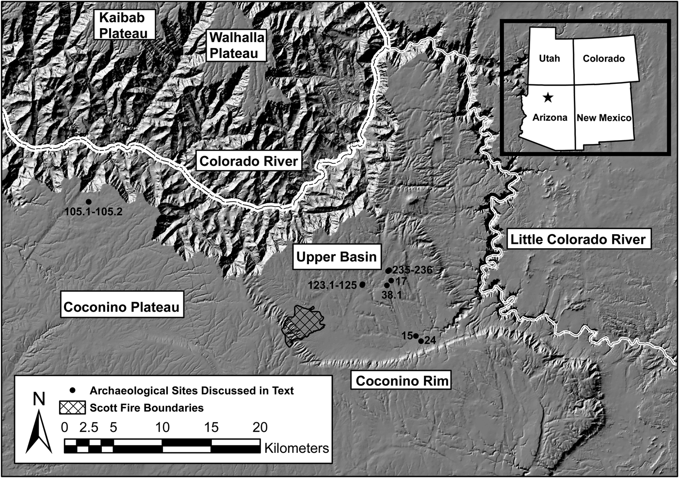
Our study area is the Upper Basin, which is a downfaulted and tilted graben of the Coconino Plateau that extends south of the eastern South Rim of the Grand Canyon (2,256 m asl at Desert View) to the base of the Coconino Rim (1,859 m asl at Lee Canyon; Figure 1). Today, the Upper Basin is blanketed by a dense pinyon-juniper woodland (Vankat Reference Vankat2013) that becomes intermixed with ponderosa pine on its western edge but grades to grassland farther south (Darling Reference Darling1967). Like so many areas in the upland Southwest occupied between AD 875 and 1200 (Euler Reference Euler and Gumerman1988), the Upper Basin is thickly stocked with abandoned one- to two-room structures and other features, such as rock alignments and terraces (Sullivan et al. Reference Sullivan, Berkebile, Forste and Washam2015), which conventionally have been interpreted as landscape signatures of maize production (e.g., Effland et al. Reference Effland, Jones and Euler1981; Stewart and Donnelly Reference Stewart and Donnelly1943). However, these appearances are deceiving when we examine the area's modern and ancient environmental characteristics and its archaeo-economic record and evaluate the extent to which they align with the attributes of maize-based foodways.
Location of the Upper Basin, northern Arizona, showing excavated sites and area burned by the Scott Fire.
Soils
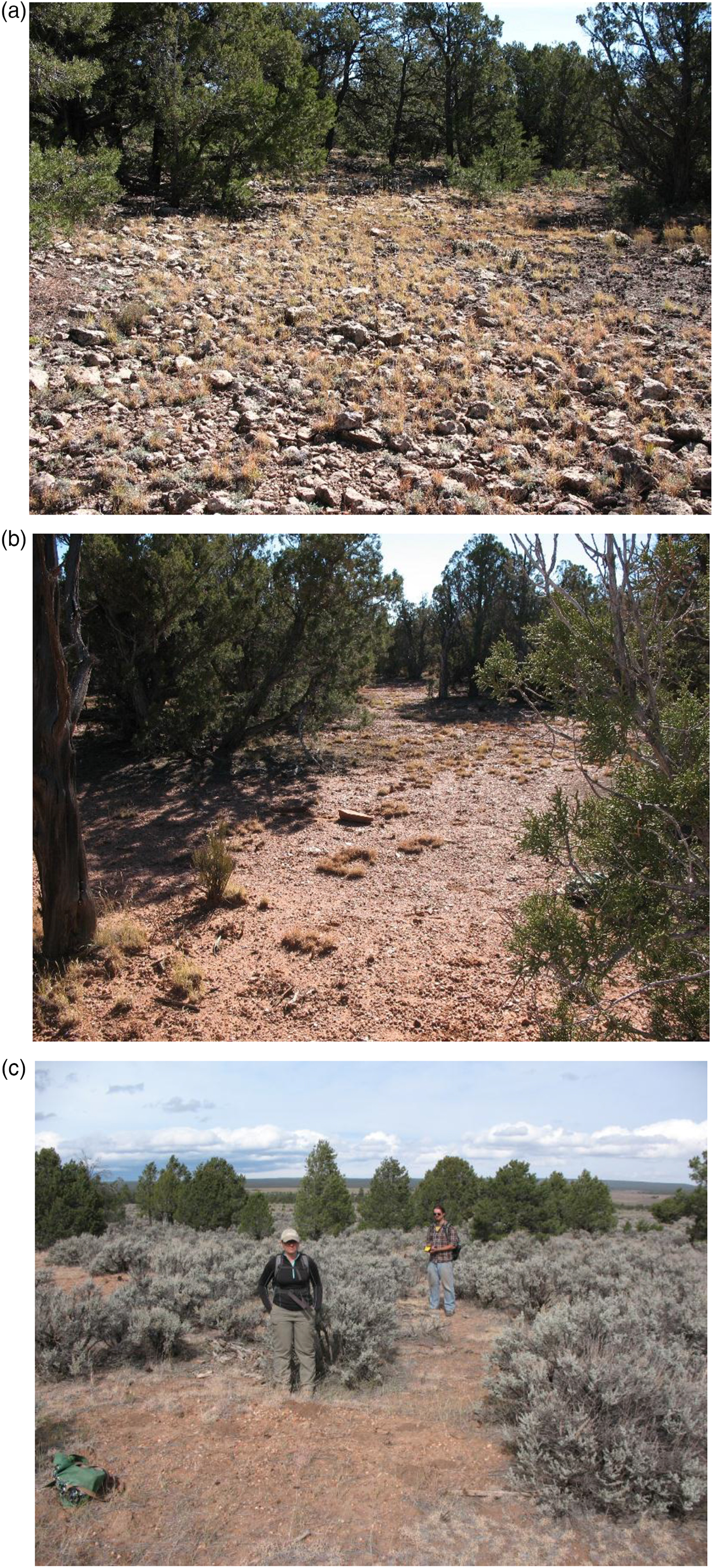
Pinyon-juniper woodlands are notorious for establishing themselves on nutrient-poor soils (West Reference West, Anderson, Fralish and Baskin1999:289), and the Upper Basin is no exception. Surface material ranges from bedrock and very cobbly/very gravelly loams in the Upper Basin's upper and central reaches (considered “agriculturally unsuitable” according to the Natural Resources Conservation Service; Lindsay et al. Reference Lindsay, Strait and Denny2003; Merkle Reference Merkle1952:377) to very gravelly/gravelly sandy loams in its lower reaches (suitable only for rangeland after “conversion;” Figure 2; Brewer et al. Reference Brewer, Jorgensen, Munk, Robbie and Travis1991). Soil chemical and texture analyses of archaeological terrace sediments (Homburg Reference Homburg and Whittlesey1992; Sullivan Reference Sullivan2000) attest to the Upper Basin's thin and rocky soils (Hendricks Reference Hendricks1985). Pollen analyses of these anthropogenic terrace sediments yielded only a dozen or so Zea mays pollen grains (<0.5%) out of thousands examined, and two sets of samples contained no maize pollen whatsoever (Bozarth Reference Bozarth and Whittlesey1992; Davis Reference Davis and Sullivan1986).
Agriculturally unproductive soils in the Upper Basin: (a) bedrock and very cobbly loam; (b) cobbly and very gravelly sandy loam; (c) very gravelly/sandy loam. (Color online)
Precipitation
With respect to the other major constraint on maize production—water availability during the frost-free growing season—hydrologic studies in the Upper Basin confirm that runoff from rainfall or snowmelt is negligible (Rand Reference Rand1965:13–14), which means that water cannot be directed to where it might be needed for maize production (Metzger Reference Metzger1961; cf. Benson Reference Benson2011:40–41). Further, interannual variation in the Upper Basin's paleoprecipitation patterns was so unpredictable (Sullivan and Ruter Reference Sullivan, Ruter, Doyel and Dean2006:185–188)Footnote 2 that, given the sensitivity of maize to the timing and amount of rain it needs to germinate (Adams Reference Adams, Ingram and Hunt2015:29–32), successful harvests were undoubtedly uncommon events (Schwartz et al. Reference Schwartz, Kepp and Chapman1981:121; see also Bocinsky and Varien Reference Bocinsky and Varien2017:299). On the other hand, importantly, even the lowest values of tree ring–reconstructed annual precipitation for the Upper Basin, that is, 25.4 cm in AD 1067, are more than adequate to ensure the survival of ruderals, such as amaranth (Salt Spring Seeds 2014:3) or chenopodium (Chenopodium quinoa [Smith Reference Smith2017:2]).
Discussion
In terms of soil fertility and frost-free precipitation, the two principal factors stipulated in maize productivity modeling studies, the Upper Basin's pinyon-juniper woodland is a “hostile” environment that is ill-suited for maize production, even during the best of times (i.e., when annual precipitation equaled or exceeded the average of 36.6 cm). It is hardly surprising, therefore, to learn that no ethnographic, ethnohistoric, or historic accounts mention maize farming in the Upper Basin or on the eastern Coconino Plateau by Native Americans or Euro-Americans (Begay and Roberts Reference Begay, Roberts and Towner1996:199–202; Cleeland et al. Reference Cleeland, Hanson, Lesko and Weintraub1990; Hough and Brennan Reference Hough, Brennan and Berger2008; Martin Reference Martin1985). These factors explain, as well, why we have encountered negligible amounts of maize remains such as botanicals or pollen (for comparable results from Black Mesa, see Ford Reference Ford, Plog and Powell1984:131; Ruppé Reference Ruppé, Christenson and Perry1985:521) in archaeological contexts that typically are associated with maize farming in the upland Southwest (Sullivan and Forste Reference Sullivan and Forste2014). In fact, no matter which consumption or production contexts are examined—structures or processing areas (Supplemental Table 1)—the archaeo-economic assemblages from them are overwhelmingly and consistently dominated by ruderal seeds and pinyon nuts (Figure 3).
Variation in the abundance and ubiquity of seeds and nuts (n = 3,485) identified in 110 samples recovered from features (postholes, thermal features, fire-cracked rock piles), artifacts (vessels, grinding stones), and occupation surfaces at 10 archaeological sites in the Upper Basin and Grand Canyon National Park (see Supplemental Table 1 for details). Each dot represents the frequency of nuts or seeds in a single sample, broken down by taxon (seeds classified by different archaeobotanists as cheno-am seeds, amaranth seeds, or chenopodium seeds are aggregated as “Cheno-am”). The data do not include counts of indirect indicators of plant use, such as cone scales, seed coats, nutshell, bark, needles, stems, leaves, wood, or cupules. This method was selected because it tightly constrains frequencies of edible plant parts—seeds or nuts—that in all likelihood were the objects of wild plant cultivation, wild plant gathering, or domesticated plant cultivation (Sullivan et al. Reference Sullivan, Berkebile, Forste and Washam2015:44). Ubiquity values are given in parentheses.

Suitability of the Upper Basin for Fire-Based Ruderal Foodways
Estimating Amaranth Consumption and Production
To illustrate the feasibility of the fire foodway provisioning strategy, we estimate how much amaranth would be required to support one person for a year. This estimate is based on the same parameters featured in numerous maize-based productivity studies and, therefore, involves the following considerations (based on Kohler et al. Reference Kohler, Kresl, West, Carr, Wilshusen, Kohler and Gumerman2000:160; Pool Reference Pool, Wingard and Hayes2013:96; Van West and Lipe Reference Van West, Lipe and Lipe1992:111):
• One person requires at least 2,000 kcal/day, which is roughly the midpoint in the published range for preindustrial populations (1,560 to 2,550 kcal/day).
• Sixty-nine percent of the annual diet was amaranth, which is roughly the midpoint of the published range for maize consumption (60% to 77%).
• One kilogram of amaranth yields 3.7 kcal (Putnam et al. Reference Putnam, Oplinger, Doll and Schulte1989:4), which is comparable to maize (3.5 kcal/kg).
With these understandings, one person would require 0.37 kg of amaranth per day, or 136 kg per year.
Although estimates for amaranth (and, for comparison, chenopodium) productivity vary widely, ranging from 340.25 to 4,310 kg/ha (Supplemental Table 2), we chose the lowest yield value (Amaranth 2) because it is from modern hand-cultivated amaranth farming, which we think more closely approximates prehistoric cultivation practices. Adoption of this value means that 0.40 ha (ca. 1 ac) of land would be needed to produce enough amaranth to satisfy one person's needs per year.
Estimating Population
To estimate the number of people that amaranth could have supported between AD 875 and 1200 in the Upper Basin, we projected the number of room spaces (n = 886) that surveys have recorded (Foust Reference Foust2015) and “time-corrected” it to yield the number of architectural spaces per 25-year period (Downum and Sullivan Reference Downum, Sullivan and Anderson1990), or roughly one human generation (cf. Roberts Reference Roberts, Miller, Moore and Ryan2011:13). These “corrections” allow us to maximize population in the face of Grand Canyon's complicated and incompletely understood population history, which involves several groups (Cohonina, Virgin Anasazi [sensu Euler Reference Euler, Euler and Tikalsky1992], and Grand Canyon Anasazi [sensu Schwartz Reference Schwartz1990]) whose perennial settlements were occupied no longer than 10–15 years (Mink Reference Mink2015; cf. Matson et al. Reference Matson, Lipe and Haase1988:253–254; Ortman et al. Reference Ortman, Diederichs, Schleher, Fetterman, Espinosa and Sommer2016:235).
Next, we calibrated the time-corrected room counts by a perennial occupancy rate. This calculation involved dividing the number of structures (n = 324) whose artifact density exceeded seven artifacts/m2 (based on an excavated perennial settlement [Sullivan Reference Sullivan, Holdaway and Wandsnider2008]) by the number of room spaces (n = 604) for which we have controlled, standardized artifact inventories (Uphus Reference Uphus2003). To convert time-corrected and perennially occupied room counts into numbers of people, we multiplied those values by 2.5 (which is the average interior floor area of 226 single-room structures [13.8 m2] divided by 5.6 m2/person [Liebmann et al. Reference Liebmann, Farella, Roos, Stack, Martini and Swetnam2016]). These estimates overrepresent the maximum number of people to be fed during any year (Supplemental Text 5). Finally, these figures were multiplied by 0.40 ha to yield the maximum number of hectares to be cultivated per year to sustain the estimated population on amaranth alone (Figure 4).
Estimated time-corrected room counts, annual population, and hectares to be cultivated under different yields (kg/ha) of amaranth and chenopodium (based on data in Supplemental Table 2).

Managing Fire-Foodway Ecological Impacts on the Landscape
In modeling the ecological impact of fire-based amaranth production, our assumption is that the Upper Basin's occupants ignited many small fires rather than a few large conflagrations (Adams Reference Adams, Nelson and Strawhacker2011:125; Scherjon et al. Reference Scherjon, Berkels, MacDonald and Roebroeks2015:309). To constrain these estimates further, we rely on Mellars's (Reference Mellars1976) classic article in which he posits that, for pinyon-juniper woodlands in northern Arizona, a burn plot no larger than 400 m in diameter (12.6 ha) maximizes ruderal production. Applying this figure to the quantities of amaranth needed to support varying numbers of people, based on differing productivity estimates, means that between five and 72 400 m diameter fires would have to be ignited per year (Table 2), burning at most no more than 4.2% of the Upper Basin (218.73 km2, excluding unburnable locations, such as bedrock and rock-filled drainages).
Estimated Number of Fires Needed per Year Based on Different Productivity Estimates for Amaranth and Chenopodium.

Note: Estimated fires are 400 m in diameter. See Supplemental Table 2 for background data.
aPeriod 1 = AD 875–1000; Period 2 = AD 1000–1050; Period 3 = AD 1050–1075; Period 4 = AD 1075–1115; Period 5 = AD 1115–1200.
bValue in parentheses indicates productivity estimate in hectares per person per year (ha/person/year).
Combining the facultative ecological orientation of niche construction theory with the methodological robustness of applied historical ecology, we propose that anthropogenic niches 1.1 km in diameter (0.95 km2) were established to enable the ignition of 400 m diameter burn plots within which ruderal production occurred (Figure 5; this configuration is comparable conceptually to the 200 m2 [4 ha] cells that have been used for maize production modeling in southwest Colorado [e.g., Kohler and Van West Reference Kohler, Van West, Tainter and Tainter1996:179]). Furthermore, we suggest that to ensure sufficient fuel accumulation to carry low-intensity surface fires, to avoid nutrient depletion that would arise from overuse, and to prevent the establishment of shrubs in the burn plots (which would decrease yields and reduce species diversity; Huffman et al. Reference Huffman, Stoddard, Springer, Crouse and Chancellor2013), each burn plot would have been used only once every three years, which is a rotational pattern that aligns with pinyon-juniper ecological succession patterns (Wagner et al. Reference Wagner, Smart, Ford, Trigg, Nichols and Smiley1984:617) and ethnographic accounts (Myers and Doolittle Reference Myers, Doolittle, Colton and Buckley2014:13; Roos Reference Roos, Mills and Fowles2017:689–690).
Randomly placed, spatially scaled anthropogenic niches (1.1 km in diameter), with insert showing embedded burn plots (400 m in diameter) by time period in the Upper Basin.
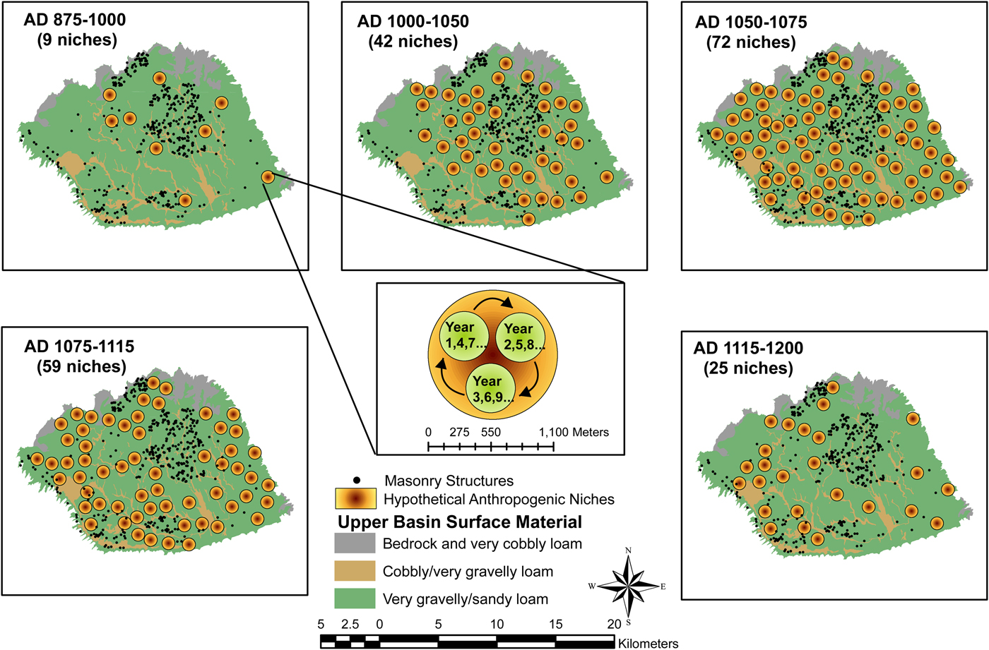
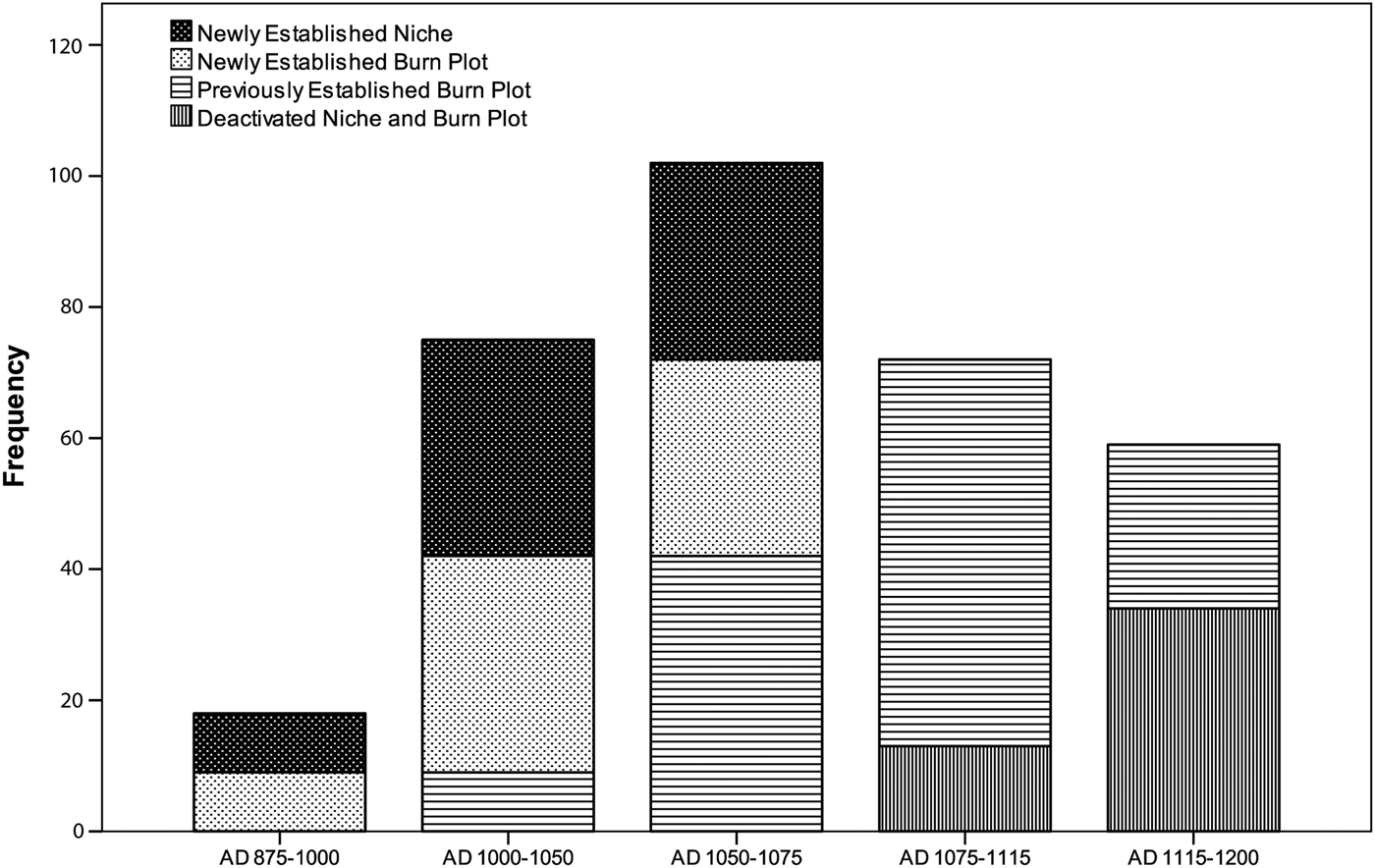
As a measure of the sustainability and low ecological impact of the fire foodway model, we predict that through time, burn plots within anthropogenic niches were deactivated and anthropogenic niches were abandoned altogether as population declined (Figure 6). For instance, if we focus on the yields for Amaranth 2 (Table 2), nine burn plots would have been established initially in nine anthropogenic niches between AD 875 and 1000. Thereafter, as population increased, the original nine anthropogenic niches would have been supplemented by 33 new ones during AD 1000–1050 and with 30 new ones during AD 1050–1075. After AD 1075, our figures indicate that no new anthropogenic niches needed to be established and, importantly, burning in previously established niches and their associated burn plots would have declined at an accelerating rate, thereby conserving the woodlands and their economic resources (cf. Peeples et al. Reference Peeples, Michael Barton and Schmich2006).
Dynamics of anthropogenic niche and burn plot establishment and abandonment in the Upper Basin through time.
The Archaeological Significance of the 2016 Scott Fire
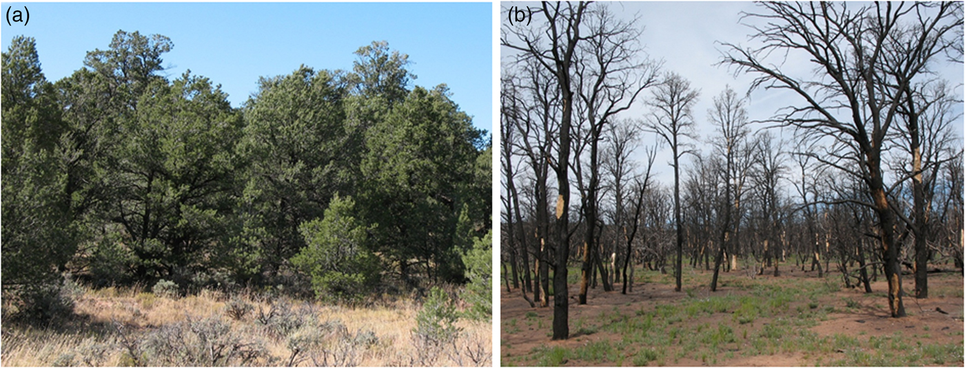
Sometime shortly after midnight on June 28, 2016, a lightning strike ignited the Scott Fire in the western reaches of the Upper Basin (Figure 1). By the time the fire was suppressed on July 18, 2016, a total of 1,076.5 ha had burned, much of it so severely that the woodland was destroyed (Figure 7), a consequence of high fuel loads attributable to fire exclusion and suppression, among other factors (Fulé Reference Fulé, Stoffel, Bollschweiler, Butler and Luckman2010:376; Vankat Reference Vankat2013:278–281).
Upper Basin pinyon-juniper woodland (a) before (2008) and (b) after (2017) the lightning-caused Scott Fire (2016). (Color online)
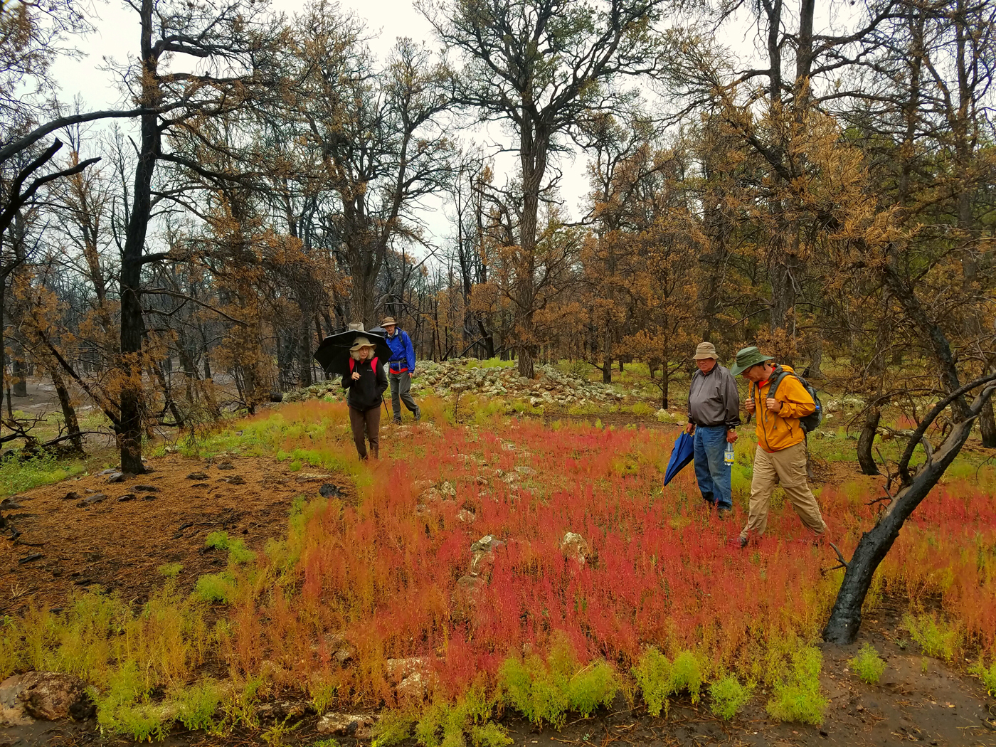
The Scott Fire is significant for the fire foodway model in several respects. First, to provide a sense of scale in considering the effects of food fires on landscapes, the area burned by the Scott Fire is larger than the highest estimated number of hectares burned based on Amaranth 2 yields, 909 ha (Table 2). Second, as Figure 8 shows, by spring 2017, significant portions of the burned area were covered by “fetid goosefoot” (Dysphania graveolens), which historically has been an economically important plant to Pueblo peoples (Springer et al. Reference Springer, Daniels and Nazaire2009:324–325). The fact that this ruderal was particularly dense in and around abandoned masonry structures suggests not only that it is fire-responsive but that its seedbed has endured for centuries (Yarnell Reference Yarnell1965). Third, that the effects of the Scott Fire on the appearance of ruderals are not anomalous can be appreciated by considering the data in Table 3, which show a uniform ruderal response despite differences in fire size, ignition type, or severity.
Aftermath of the Scott Fire, which burned 1,076.5 ha in the Upper Basin between June 28 and July 18, 2016, showing dead trees and prehistoric masonry structure surrounded by fetid goosefoot in April 2017 (image used with permission of Neil Weintraub, Kaibab National Forest, US Department of Agriculture Forest Service).
Forest Fires in the Upland American Southwest that Produced Amaranth or Chenopodium.

aOne to two years post-burn.
In addition to providing evidence for Yarnell's (Reference Yarnell1965) “Camp Follower” hypothesis, which is intended to explain abnormally high densities of wild economic plants in and around archaeological sites, the results of our study lend support for Henry Dobyns's (Reference Dobyns1972) “Altitude Sorting” hypothesis. Based on ethnohistoric accounts that describe the ubiquity of amaranth and chenopodium production in New World economies, widespread archaeological occurrences of cheno-ams in the American Southwest, and the environmental constraints on maize farming, particularly for densely occupied upland locales after AD 1000, Dobyns proposed that upland groups “depended upon amaranth and perhaps chenopodium cultivation,” in contrast to populations living in lower elevations that “grow more corns, beans, squash, and cotton, and less chenopodium and amaranth” (Reference Dobyns1972:45; see Bohrer Reference Bohrer1991:232–233 on the use of fire for ruderal production in the Sonoran Desert). The results of our and other modern archaeological investigations broadly align with the Camp Follower and Altitude Sorting hypotheses (e.g., Merrill et al. Reference Merrill, Hard, Mabry, Fritz, Adams, Roney and MacWilliams2009) and indicate that maize dependency was localized and uneven across the prehispanic American Southwest (Bayman and Sullivan Reference Bayman and Sullivan2008; Rocek Reference Rocek1995; cf. Spielmann et al. Reference Spielmann, Nelson, Ingram and Peeples2011).
Fire-Based Ruderal Production and the Economic Prehistory of the American Southwest
From southwestern Arizona (Bayman et al. Reference Bayman, Palacios-Fest, Fish and Huckell2004:132) to northeastern New Mexico (Kirkpatrick and Ford Reference Kirkpatrick and Ford1977) and from southeastern Nevada (McGuire et al. Reference McGuire, Hildebrandt, Gilreath, King and Berg2014) to southeastern New Mexico (Jelinek Reference Jelinek1966), archaeological evidence indicates that chenopodium and amaranth have been economic keystone species for centuries in the Southwest (Fritz et al. Reference Fritz, Bruno, Langlie, Smith, Kistler, Sayre and Bruno2017) and elsewhere in the New World (Carmody et al. Reference Carmody, Sherwood and Hoagland2017). The method of their cultivation, however, is poorly understood (Ford Reference Ford1981:22) because considerations of the economic effects of burning have not been coupled with the understanding that these plants are fire-responsive and that fire was an essential food-producing technology of prehistoric Southwestern societies. The plausibility of the fire-foodway model can be appreciated, we suggest, by embracing the idea that the effects of low-intensity burning on understory vegetation align with forest ecology, fire ecology, and the contents of the archaeobotanical record in ways that maize agriculture does not. Moreover, with human-controlled landscape fire, people actively manage the structure and composition of vegetation communities by disrupting ecological succession patterns, manipulating understory fuel loads, and rotating burn plots to encourage species diversity without soil nutrient loss (Bird Reference Bird2015). In short, the evidence indicates that sustainable fire-based ruderal agriculture was practiced extensively and in areas where maize agriculture was a risky and insecure endeavor (Dean Reference Dean, Tainter and Tainter1996).
We realize that some aspects of this model are ideal, if not mechanistic, constructs, for example, the size of burn plots, number of annual fires, and duration of fallow periods, but they serve to illustrate that, even when considering the lowest yields of just one plant and the caloric needs of the highest levels of population, fire foodways could easily provision the occupants of pinyon-juniper woodlands in areas that are environmentally hostile to maize farming. In addition, in view of the low impact of ruderal cultivation on pinyon-juniper woodlands, food fires could be ignited virtually continuously wherever sufficient fuels accumulate without jeopardizing the integrity of the ecosystem and its other economic resources, such as pinyon nuts and cactus (cf. Innes et al. Reference Innes, Blackford and Rowley-Conwy2013:88). In this regard, Lanner's observation that “the food potential of piñon forests in the Southwest has never been reliably estimated, but it is enormous” (Reference Lanner1981:105) is supported by our rough estimates of fire-responsive ruderal yields. Importantly, significant quantities of economic resources can be produced without much labor, without destroying the woodlands themselves, and by increasing edible biomass enormously, particularly if more than one ruderal was cultivated (Bye Reference Bye1981; Ford Reference Ford, Plog and Powell1984:135–137).
By incorporating aspects of the forest ecology and fire ecology of the Southwest's pinyon-juniper woodlands, our study illustrates the synergistic potential of applied historical ecology and niche construction theory in revealing the effects of anthropogenic fire in transforming the carrying capacity of these once heavily occupied ecosystems. Hence, it seems unlikely that the livelihoods of the prehistoric occupants of the Southwest's pinyon-juniper woodlands were challenged by slowly regenerating resources, by low carrying capacity, by scarce wild resources, and by the uncertain effectiveness of slash-and-burn maize cultivation (Wilcox Reference Wilcox and Ward1978). It is more ecologically realistic to view these woodlands as having been structured by the historic dynamics of anthropogenic fire regimes—systematic understory burning during periods of occupation, dramatic reduction of understory burning during periods of abandonment, and exclusion or suppression of fire during the twentieth century (Margolis Reference Margolis2014).Footnote 3
Conclusion
In archaeological contexts across the prehistoric American Southwest, the widespread ubiquity and high frequencies of ruderal plant remains—especially seeds and pollen from amaranth and chenopodium—support the proposition that the cultivation practices for these plants involved deliberately set understory fires (Sullivan and Forste Reference Sullivan and Forste2014). Furthermore, we think that anthropogenic fires, which triggered the disturbances that enabled ruderal production whenever and wherever sufficient understory fuels had accumulated, represent a form of sustainable agriculture whose yields were independent of the problematic rainfall and soil conditions that bedevil maize productivity and made it such a risky venture (Bocinsky and Varien Reference Bocinsky and Varien2017). The systematic management of understory fuel loads with low-intensity burning not only provided a dependable food supply, whose productive capacity was controlled by the ecosystem's inhabitants, but insulated the forests from catastrophic crown fires by eliminating the ladder-fuel problem that makes our overgrown woodlands so vulnerable to wildfires today (Huffman et al. Reference Huffman, Stoddard, Springer, Crouse and Chancellor2013), as the Scott Fire dramatically demonstrates.
Ruderal-producing fire foodways were sustainable because they required minimal fuel loads and efforts to ignite them, could be prosecuted on the most agriculturally unproductive soils, and, in the case of amaranth specifically, did well with less than 25 cm of precipitation and did not deplete soil of nitrogen to the same degree as maize. Intercropped with other drought-resistant, fire-responsive ruderals, such as chenopodium and various grasses, low-intensity understory “food fires” created a foodway that was largely inoculated against long-term climatic change and short-term environmental variability (Fulé et al. Reference Fulé, Wallace Covington, Moore, Heinlein and Waltz2002a:44). Moreover, fire foodways take advantage of highly predictable successional pathways (Barney and Frischknecht Reference Barney and Frischknecht1974) that virtually guaranteed, with fire rotation (i.e., resting formerly burned areas for a year or two to promote fuel regeneration; Lightfoot and Cuthrell Reference Lightfoot and Cuthrell2015:1585), interannual continuity in food provisioning (Bates and Davies Reference Bates and Davies2016:127). Hence, this sustainable strategy contributed to a degree of food security that was rarely enjoyed by maize-based foodways in view of their vulnerability to capricious and largely uncontrollable environmental factors. The fire-foodway model illustrates that, by integrating archaeobotanical, fire-ecological, and surface archaeological data, we can enrich our narratives about how groups of economically autonomous people, with the judicious application of fire, engineered landscapes and secured livelihoods by unleashing the productivity capacity of ancient pinyon-juniper woodlands—upland ecosystems whose fire regimes, structure, and appearance have few counterparts in the twenty-first century.
Acknowledgments
Financial support for the Upper Basin Archaeological Research Project has been provided by the US Department of Agriculture Forest Service, the National Center for Preservation Technology and Training (National Park Service), the National Geographic Society/Waitt Grants Program, the C. P. Taft Research Center (University of Cincinnati), and the University Research Council (University of Cincinnati). We are grateful to Dr. Maria Nieves Zedeño (University of Arizona) and to Dr. Jeff Jacobson (University of Cincinnati) for translating our abstract into Spanish. Archaeological investigations in Grand Canyon National Park during 2012 and 2014 were authorized by permits GRCA-2012-SCI-0006 and GRCA-2014-SCI-0033. Federal housing occupancy and archaeological investigations in Kaibab National Forest were authorized by Special Use Permits TUS85-352 (2012) and KAI105 (2014), respectively.
Data Availability Statement
Specialist reports of macrobotanical and pollen analyses, data files of archaeological survey records (including differentially corrected GPS data), and GIS shapefiles of Upper Basin environmental and archaeological characteristics used in the preparation of this article are available by contacting the corresponding author. In addition, primary archaeobotanical data referred to in this essay, including sample collection and analysis procedures, context types, sample numbers, identified taxa, nomenclature protocols, plant part, specimen condition, the presence or absence of charring, and miscellaneous comments, may be found by consulting the following sources: Berkebile (Reference Berkebile2014); Brandt (Reference Brandt1991); Cummings and Puseman (Reference Cummings and Puseman1995, Reference Cummings and Puseman1997, Reference Cummings, Puseman and Downum2010); Huckell (Reference Huckell and Whittlesey1992); Scott (Reference Scott and Sullivan1986).
Supplemental Materials
For supplemental material accompanying this article, visit https://doi.org/10.1017/aaq.2018.32.
Supplemental Table 1. Archaeological Characteristics of 10 Excavated Sites in Grand Canyon National Park and the Upper Basin, Northern Arizona, that Produced Macrobotanical Samples.
Supplemental Table 2. Productivity Estimates of Amaranth and Chenopodium.
Supplemental Text 1. Key References Consulted about the Relation between Anthropogenic Fire and Human Prehistory.
Supplemental Text 2. Key References Consulted about the Relation between Anthropogenic Landscape Fire Ecology and Subsistence Economies.
Supplemental Text 3. Key Ethnographic, Ethnohistoric, and Cross-Cultural Studies Consulted about Anthropogenic Landscape Burning.
Supplemental Text 4. Key References Consulted about Maize and Amaranth Evolution and Cultivation in the New World.
Supplemental Text 5. Population and Amaranth Productivity Estimates for the Upper Basin, AD 875–1200.


 Open access