Pueblo Bonito (Figure 1) is arguably among the most important archaeological sites in the U.S. Southwest. Yet despite over a century of research, its origins, construction sequence, size, occupants, function and abandonment remain topics of debate (see Vivian Reference Vivian1990; Mills Reference Mills2002; Neitzel Reference Neitzel2003; Lekson Reference Lekson2006, Reference Lekson2007; Heitman & Plog Reference Heitman and Plog2015). Why are archaeologists unable to reach consensus on Pueblo Bonito? Here we propose that the site confounds interpretation due both to its excavation history and the fact that its inhabitants settled into a never-ending project of construction, remodelling, renewal and destruction (Figure 2). In this article, we review the origins, construction sequence and abandonment of Pueblo Bonito. This builds on earlier research highlighting evidence for frequent renewal projects at the site (Crown & Wills Reference Crown and Wills2003), and incorporates new data from our 14 years of excavation and analysis. We conclude that the history of this great house may never be fully understood—in part because its builders never considered it to be finished.
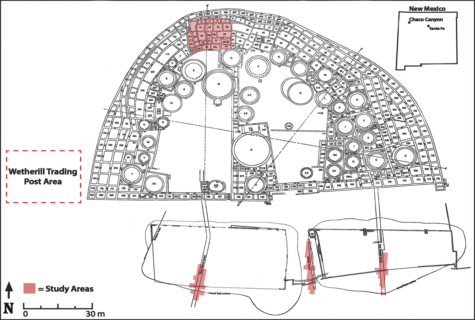
Map of Pueblo Bonito, highlighting areas of new excavation. Figure by Beau Murphy and Wetherbee Dorshow.
1897 photograph of Room 70 in Pueblo Bonito, illustrating the complexity of the architectural sequence. Image #411995, American Museum of Natural History Library.
Background to understanding Pueblo Bonito
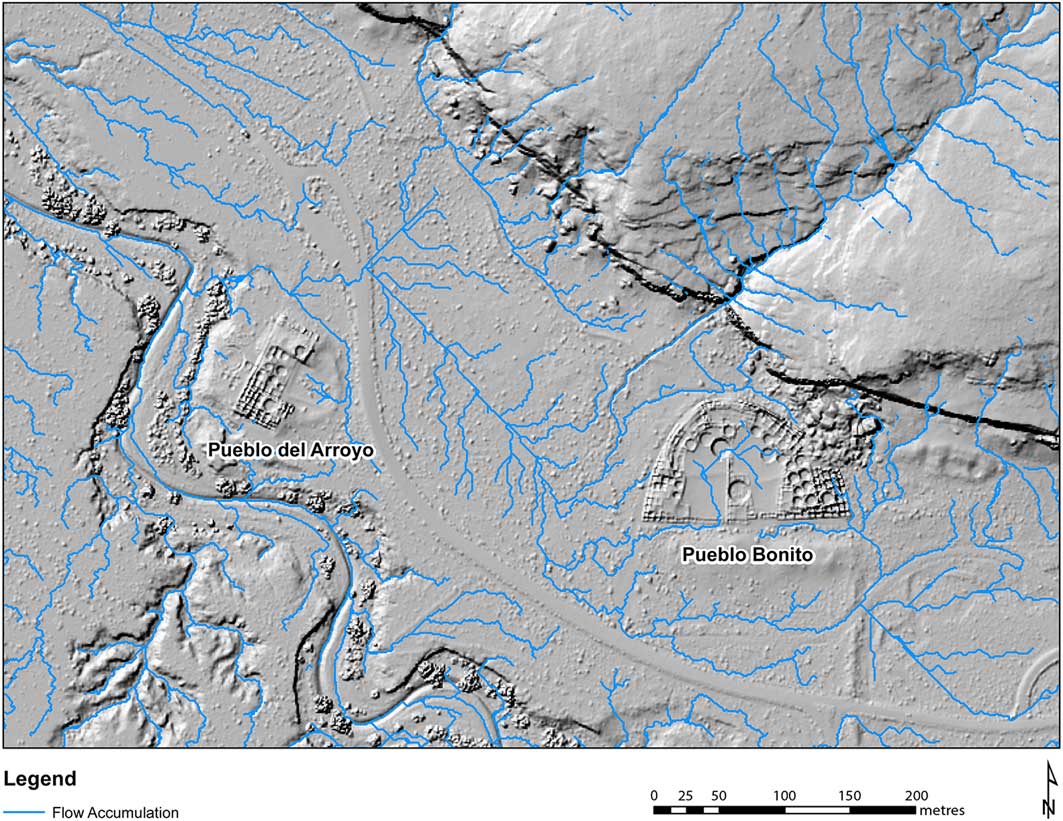
Pueblo Bonito is located in Chaco Canyon in north-western New Mexico, at an elevation of approximately 1890m asl. Average modern annual precipitation is around 225mm, with record minimum and maximum temperatures ranging from −34 to 38°C. The canyon is cut through Cretaceous sandstones, forming vertical cliffs on the north and south margins of the floodplain, which is 0.75km wide at Pueblo Bonito. The valley floor is dissected by the Chaco Arroyo, which has a complex history of aggradation and erosion; its current course formed in the nineteenth century AD (Wills et al. Reference Wills, Love, Smith, Adams, Palacios-Fest, Dorshow, Murphy, Sturm, Mattson and Crown2016).
Two major archaeological projects have excavated most of Pueblo Bonito. From 1896–1899, the Hyde Exploring Expedition excavated around 200 rooms, under the supervision of Richard Wetherill and George Pepper (Pepper Reference Pepper1909, Reference Pepper1920). The National Geographic Society sponsored excavation of much of the rest of the site between 1921 and 1927, directed by Neil Judd (Judd Reference Judd1954, Reference Judd1964). Smaller excavations include work associated with stabilising the site and to extract wood samples for dating (Vivian Reference Vivian1940; Windes & Ford Reference Windes and Ford1992, Reference Windes and Ford1996). Since 2004, the University of New Mexico has conducted re-excavations (Figure 1) in the two refuse mounds south of the site (Crown Reference Crown2016; Wills et al. Reference Wills, Love, Smith, Adams, Palacios-Fest, Dorshow, Murphy, Sturm, Mattson and Crown2016), the Wetherill Homestead area immediately west of Pueblo Bonito, and in Room 28 in the northern part of the site. Our discussion here is based on data from these investigations, as well as the documentary records (available at www.chacoarchive.org).
Pueblo Bonito is amongst the largest and most completely excavated archaeological sites in the U.S. Southwest. It encompasses approximately 600 masonry rooms up to four storeys in height, as well as around 37 semi-subterranean masonry-lined structures (kivas), which were probably used primarily for ritual activities. In the Chaco area, such sites are called ‘great houses’ to distinguish them from much smaller single-storey villages, which lack many of the features of the larger sites. Great houses are often described as ‘monumental’ in scale (Lekson Reference Lekson1984). Archaeologists date Pueblo Bonito based on stratigraphy, masonry styles, bonding/abutting of wall corners, ceramics, as well as tree-ring, radiocarbon and archaeomagnetic samples (see Windes Reference Windes2003). There are, however, problems with all of these dating techniques. In particular, Chacoans reused wood from old structures when building new structures, refurbished older rooms with new pieces of wood and remodelled tirelessly. Reconstructing the sequence is critical for addressing important issues at Pueblo Bonito. These include whether the site represents a local development or a migration of populations from outside the canyon, how the site reflects changing architectural and societal constructions, and what socio-economic strategies were required to manage construction events.
Origins: what lies beneath
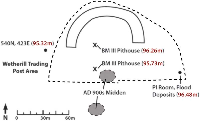
Pueblo Bonito was built on a location occupied during the Basketmaker III Period (c. AD 450–750), a period characterised by agricultural economies and the first ceramics in the northern U.S. Southwest. Basketmaker III-Period ceramics are present in small amounts at Pueblo Bonito, indicating occupation in the seventh and eighth centuries AD. Basketmaker III-Period settlements consisted of dispersed single-room pithouses, extramural storage bins and, in some cases, a large public structure called a great kiva. Basketmaker III-Period sites are common around Pueblo Bonito—especially opposite the great house on the south side of the canyon (Judd Reference Judd1924; Dutton Reference Dutton1937; Kluckhohn Reference Kluckhohn1939; McKenna & Truell Reference McKenna and Truell.1986; Wills & Windes Reference Wills and Windes1989; Wills et al. Reference Wills, Worman, Dorshow and Richards-Rissetto2012; Windes Reference Windes2014). At Pueblo Bonito, Judd (Reference Judd1964) encountered two pithouses under the West Court (Figure 3), around 4m below the current surface. These appear to be Basketmaker III Period in date, at elevations consistent with radiocarbon-dated layers of mixed fluvial and cultural deposits documented in test units approximately 15m west of the great house (discussed below).
Location of deeply buried Basketmaker III-Period pithouses, Pueblo I structures, features, refuse accumulations and flood deposits relative to the architectural footprint at AD 900 (crescent shape) and AD 1100 (dashed line). The site datum elevation is 100m and located on the West Mound (see Figure 1). Figure by Beau Murphy.
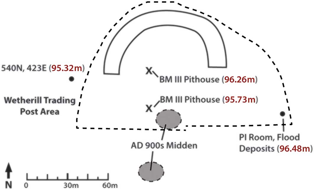
Between c. 100 BC and AD 1000, the valley bottom in Chaco was a relatively flat, seasonally wet flood plain (Hall Reference Hall2010: 236). Although pollen data do not indicate the presence of perennial wetlands in Chaco during this period, Bryan (Reference Bryan1954: 51) suggests that marshy areas along the base of the north-side cliffs may have supported cattails and other riparian plants. Mesa-top runoff pours over the edge at a number of places on the north side of the canyon, creating temporary pools and small channels that flow onto the floodplain. Archaeological data suggest that this combination of convergent water sources was critical for farming during the Basketmaker III Period in Chaco (Wills et al. Reference Wills, Worman, Dorshow and Richards-Rissetto2012)—including in the area where Pueblo Bonito would be built.
Tree-ring dates indicate that construction of Pueblo Bonito began in the ninth century AD and continued into the early tenth century, thus spanning the conventional temporal boundary between Pueblo I (c. AD 750–900) and Pueblo II (c. AD 900–1100). This was a dynamic cultural period in Chaco Canyon that saw the number of habitation sites double from the Basketmaker III Period. Windes (Reference Windes2014) has documented the appearance of distinct communities during this interval along the entire length of the canyon and adjacent tributaries. These were characterised by dispersed household structures surrounding a larger masonry building. Pueblo Bonito fits this pattern, particularly in having two large tenth-century middens that were later buried by expansion of the pueblo (Figure 3). Wilshusen and Van Dyke (Reference Wilshusen and Van Dyke2006) believe that the canyon population during the ninth century AD was modest in size. Nonetheless, they acknowledge that Pueblo Bonito and other post-ninth-century great houses probably obliterated or buried preceding settlements, making it difficult to estimate the size of earlier local populations.
Unlike the wide, shallow drainages outside Chaco, the canyon alluvial environment was aggrading between AD 800 and 1000. Many late eighth- and ninth-century structures located on the valley floor, and exposed through excavation or erosion, are buried by flood deposits (Judd Reference Judd1924; Adams Reference Adams1951; Bryan Reference Bryan1954; Bradley Reference Bradley1971; Wills et al. Reference Wills, Worman, Dorshow and Richards-Rissetto2012). Similar flooding may have affected the early occupation at Pueblo Bonito; the great house is located on deep sandy sediments at the base of a cliff—slightly higher than the adjacent floodplain today (Figure 4). Deep stratigraphic test pits below rooms in the south-east part of Pueblo Bonito and outside the western walls have encountered distinctive strata of water-lain silts interfaced with layers containing ash, charcoal and artefacts. More than two metres below the floor of Room 241, estimated to have been built between AD 1075 and 1085 (Lekson Reference Lekson1984), these deposits covered a floor surface and razed wall consistent with ninth-century building techniques (Judd Reference Judd1964: 77). Three recently excavated test units located 10–20m west of Pueblo Bonito revealed alternating layers of sand and silt-clay layers mixed with cultural material. These layers sloped to the west (Figure 5), and formed as floodwaters receded and became less turbulent. These data indicate that seasonal floods extended over some parts of ninth-century Pueblo Bonito.
Modern surface water flow-accumulation model for the area around Pueblo Bonito. Terrain model constructed from LiDAR data (www.ncalm.org) by Joseph Birkman.
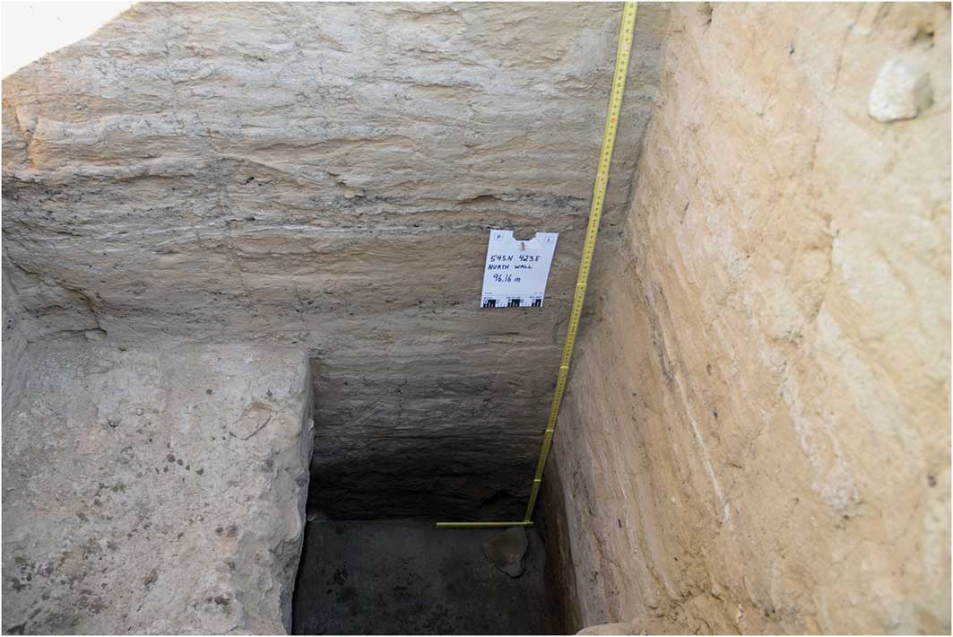
North profile of 545 north 423 east, in the Wetherill Trading Post area approximately 15m west of Pueblo Bonito, showing alternating sand, silt-clay layers and charcoal-ash lenses. Charcoal from the base of the unit (95.31m, site datum is 100m) is dated at 551–636 cal AD; charcoal at 95.39m is dated at 772–887 cal AD; charcoal at 96.12m is dated at 889–986 cal AD (respectively: samples AA109842, AA109843 and AA109841 (95.4%, OxCal4.2/IntCal13, Bronk Ramsey Reference Bronk Ramsey2009; Reimer et al. Reference Reimer, Bard, Bayliss, Beck, Blackwell, Bronk Ramsey, Buck, Cheng, Edwards, Friedrich, Grootes, Guilderson, Haflidason, Hajdas, Hatté, Heaton, Hoffmann, Hogg, Hughen, Kaiser, Kromer, Manning, Niu, Reimer, Richards, Scott, Southon, Staff, Turney and van der Plicht.2013)).
It has been suggested that construction of Pueblo Bonito began abruptly because the first distinctive architectural units seem to appear fully formed and without precedent (Wilshusen & Van Dyke Reference Wilshusen and Van Dyke2006). Windes and Van Dyke (Reference Windes and Van Dyke2012: 100) suggest that migrants from the San Juan River area, approximately 190km north of Chaco, were responsible for this initial construction based on similarities in architecture. There is, however, currently no independent archaeological evidence—such as ceramic patterning or biochemical data—that supports an influx of northern populations in the ninth century AD (see Kantner Reference Kantner2012; Price et al. Reference Price, Plog, Leblanc and Krigbaum.2017; Mills et al. Reference Mills, Peeples, Aragon, Bellorado, Clark, Giomi and Windes2018).
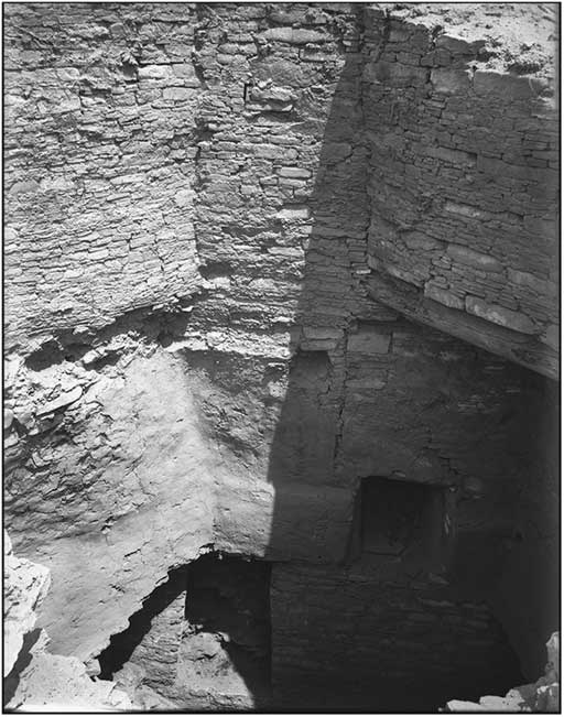
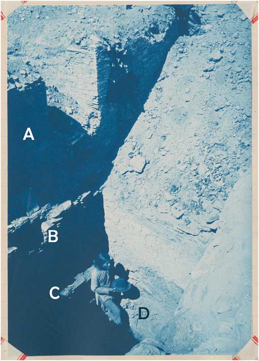
Furthermore, recent excavations in the north-central part of the building, combined with archival materials, provide new information suggesting that the earliest settlement might have been larger than previously assumed, both in terms of the number of rooms and population size. The earliest rooms in this northern area had masonry walls, and may have been of the architectural form called ‘tub’ rooms, which may be restricted to the San Juan Basin (Windes Reference Windes1993). Tub rooms had square to rounded masonry walls with floors that included a central, bathtub-shaped depression 200–400mm deep, surrounded by shelves 150–250mm wide (Windes Reference Windes1993). Pueblo Bonito rooms believed to date to the late AD 800s or early 900s (Windes Reference Windes2003) have possible tub rooms underlying them. Pepper (Reference Pepper1920: 126–28), for example, found two floors in Room 28a, at depths of 1.83m and 2.59m below the ceiling level of the room. The higher floor corresponds to the depth of the floor we located in adjacent Room 28, but the lower floor was excavated 0.3m into sterile sand. A photograph of the room (Figure 6) shows shelf projections around the workman standing on the lower floor, supporting the idea that this was a tub room. Immediately to the south of this room and at approximately the same elevation, Judd (Reference Judd1964: 76–77) found the possible remains of a second tub room. Based on stratigraphy and depth, two additional rooms found under Room 56 are probably contemporaneous (Figure 7; Pepper Reference Pepper1920).
1897 photograph of excavations in Room 28a: A) upper-storey wall constructed c. AD 1071; B) lower-story wall constructed c. AD 850–925; C) lower-storey floor; D) shelf-like projections of probable tub room. The workman stands on the tub room floor. The sloping backfill sits in Room 28 to the west. Catalogue # Hyde Exploring Expedition 184. Courtesy of the Division of Anthropology, American Museum of Natural History.
Possible tub rooms in black, with later rooms and known postholes in grey. Figure by Drew Wills.
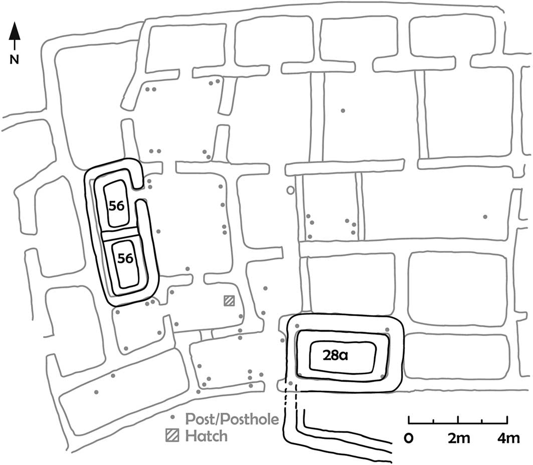
Given the probable chronology of the rooms above these subfloor features, these earlier rooms must date to the AD 800s—and probably the early 800s—dates supported by ceramics from adjacent surfaces. Tub rooms usually have adjacent ramadas (roofed shelters without walls; Windes Reference Windes1993: fig. 4.1), which may explain the concentration of postholes found in late nineteenth-century Hyde Exploring Expedition excavations of later masonry rooms located adjacent to the probable tub rooms (Figure 7). Thus, some of the postholes shown in Figure 7 may have served to support ramadas adjoining the tub rooms and then been incorporated into the later room construction. Strata beneath the Room 28 floor that are probably contemporaneous with the structure under Room 28a contain large numbers of turkey gastroliths, suggesting that turkeys were kept there. In other sites in Chaco with tub rooms, the rooms are situated west or north of pithouses (see also Wilshusen & Van Dyke Reference Wilshusen and Van Dyke2006). Unfortunately, any pit structures located south or east of Room 28a would have been disturbed by the later construction in the West Court. Other parts of Pueblo Bonito have structures beneath what are generally considered the earliest rooms at the site (including a probable kiva under the ground floor of Room 83 (Pepper Reference Pepper1920), along with the room found deeply buried beneath Room 241, mentioned above).
Between c. AD 850 and 925, the inhabitants of Pueblo Bonito constructed masonry rooms that varied from one to four storeys in height and used diverse construction methods (Figure 8). These include: the use of large sandstone blocks, with little evidence of mortar; smaller, tabular pieces of sandstone laid closely without defined rows; jacal (wattle-and-daub); and stone courses widely spaced by large quantities of mud. Importantly, exhausted grinding stones incorporated into the masonry walls support the idea of an extensive local settlement prior to the construction of these rooms. Rooms fronting the plazas (including Rooms 28, 323, 325 and 326; Judd Reference Judd1964) had many postholes situated primarily on the plaza side of the room. These plaza-side postholes had cones of adobe at the base that sloped gradually downwards to the floor. These may have initially supported a ramada, with the room walls added later. The high concentration of posts in some masonry rooms (e.g. Rooms 28, 32, 33, 53, 61) contrasts with rooms with no posts. This may provide evidence that ramadas or jacal-walled rooms preceded the masonry rooms. Indeed, the largely linear nature of the rooms with posts suggests that the area from Rooms 28–61 might have consisted of jacal rooms fronting small masonry storage rooms (e.g. Room 33 and the two rooms under Room 56) with a courtyard to the east. Later construction then shifted the ‘front’ of this part of Pueblo Bonito from east- to south-facing.
Ground-floor rooms in the north-central part of Pueblo Bonito, probably constructed in the interval from c. AD 850–925. Figure by Drew Wills.
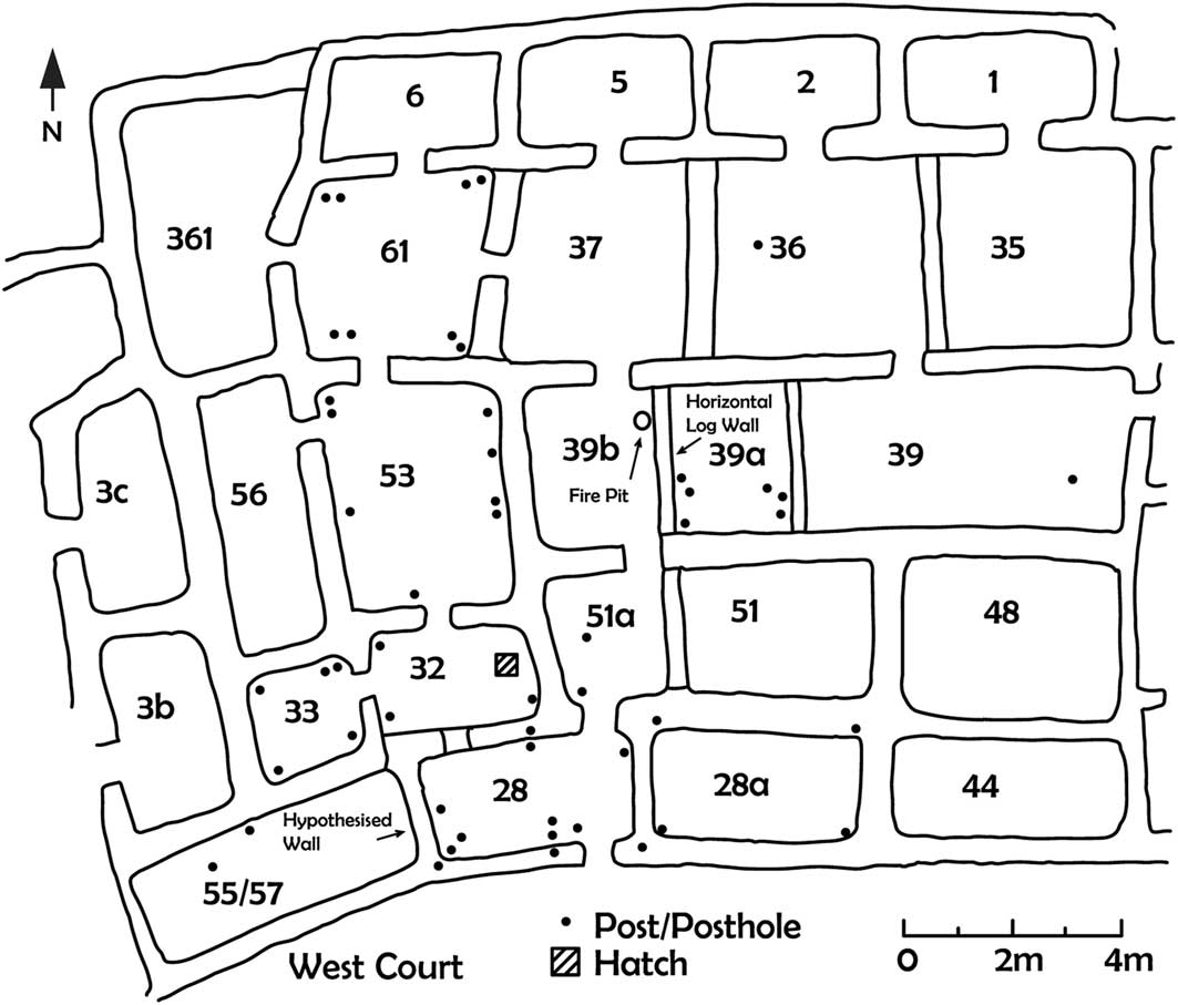
The diverse wall-construction techniques indicate a lack of a unified architectural style in this early period. This may suggest construction by individual households using their own building methods, a lack of architectural specialists, or such widely spaced construction episodes that individuals lacked continuity in ways of building. Whatever the reasons, the early architecture of Pueblo Bonito shows a great deal of variation. One favoured building method that emerged during this time was the construction of a long narrow room that was divided with interior walls. In the northern area, Rooms 35, 36, 37, 39, 39a, 39b and 61 show this pattern, with interior cross walls comprising masonry, horizontal logs, or a combination of jacal and masonry (Pepper Reference Pepper1920). These interior walls could be destroyed and moved as needs changed. Small rooms constructed behind these large rooms are usually assumed to be for storage (Vivian Reference Vivian1990). As shown in Figure 8, the rooms fronting the West Court probably constituted three separate single-storey rooms, each with straight walls, but placed slightly askew to create a curve.
By the mid tenth century, this northern portion of Pueblo Bonito had approximately 25 ground-floor rooms. Burials recovered in Rooms 33 and 56 show that these rooms were eventually used as burial crypts. Initially, however, the other rooms appear to have served as domestic spaces, including as use for habitation, cooking and storage. Our excavations in Room 28, for example, revealed several shallow, amorphous pits dug into the sand floor that served as thermal features. While formal hearths are relatively rare in Pueblo Bonito rooms, less formal features might have served for heating and cooking. This may confound attempts to estimate population levels based on the number of hearths (Windes Reference Windes1984; Bernardini Reference Bernardini1999). Pollen samples taken from a surface immediately beneath the floor and associated with the construction of Room 28 contain copious amounts of cattail pollen (Smith forthcoming), supporting the possible contemporaneous presence of a marshy area near the village.
Tree-ring dates indicate a hiatus in building activity throughout Pueblo Bonito between c. AD 975 and 1040. People may have abandoned part or all of the site during this interval. Although occupation of the existing rooms (without new construction) may have continued, areas of the village were “left unmaintained and then partly collapsed before new construction in the A.D. 1040s” (Windes & Ford Reference Windes and Ford1996: 301). Remodelling was such a continuous process at Pueblo Bonito that the absence of dates in this interval is striking.
When construction resumed in the northern rooms in the AD 1000s, the surface of the West Court had risen so much that it was approximately level with the roofs of the first-storey rooms. Judd (Reference Judd1964: 60) suggested that wind-blown sand contributed to this. Sand also piled up against the rear rooms, and new rooms were built on the accumulated sand (Lekson Reference Lekson1984: 133). While Judd saw these deposits as natural accumulation, Stein et al. (Reference Stein, Ford and Friedman2003: 50) argued that occupants of Pueblo Bonito raised the surface level artificially. It is possible that the deposits represent both natural and cultural accumulation, particularly as excavation of large kivas may have deposited material around them. In the case of Room 28, which had a door leading to the West Court, the higher ground surface would have made this entrance inaccessible.
The eleventh century was a time of intensified building activities and remodelling at Pueblo Bonito. Tree-ring dates suggest construction of at least 80 new rooms at the rear of the pueblo from AD 1040–1050. Another 24 rooms were built between AD 1050 and 1070, and perhaps another 160–170 rooms between AD 1070 and 1100 (Windes & Ford Reference Windes and Ford1996: 302–303). Remodelling activities in the northern area included the replacement of Room 28’s north wall, the foundation clay for which sits on the floor level of the earlier room. The wall exhibits Type II masonry—a style believed to characterise the time between AD 1020 and 1060.
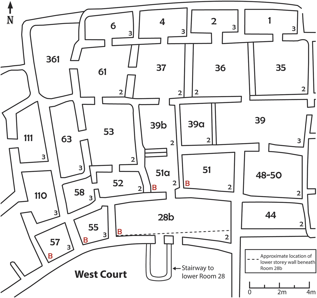
Within a few decades, a new wall was added on the West Court side of the entire set of rooms from Room 28a to Room 57 at the same time that a second storey was added onto this arc of rooms (Figure 9). The new south wall for these rooms was two storeys high along the northern part of the West Court and set onto a foundation 0.53m high. It must have been constructed by digging out the accumulated wind-blown sand deposits and placing the wall parallel to and just south of the existing north wall. The wall arc has a smaller diameter than the room walls it parallels, touching the wall of Room 28 but then curving away from the walls of the surrounding rooms to an ever greater extent. Figure 6 shows this upper wall creating a bench adjacent to Room 28a. The lower-storey ceiling sat on this bench. Tree-ring dates from the new upper-storey rooms suggest construction in AD 1071—a date congruent with the Type IV masonry style (Lekson Reference Lekson1984: 19). New upper-storey Room 28b covered both lower Rooms 28 and 28a, and was fitted with two side-by-side T-shaped doorways. This unique configuration may have been important for ceremonial processions into the West Court (Crown Reference Crown2018). A stairway framed inside masonry/mud walls was constructed from the West Court down to lower Room 28 (Judd Reference Judd1954: 27), permitting individuals to enter and leave the now-underground set of rooms shown in Figure 8.
Configuration of north-central rooms after addition of a new wall on the northern side of the West Court. Small numbers in the right-hand corners are numbers of stories, based on Pepper (Reference Pepper1920) and Judd (Reference Judd1964). Red ‘B’ indicates burned rooms. Figure by Beau Murphy.
These underground rooms in the northern portion of Pueblo Bonito continued to be used, probably primarily for storage. A number of them were found to contain quantities of objects interpreted as being of ritual use (Neitzel Reference Neitzel2007: 139), and perhaps owned by ritual or kin groups. In Room 28, for example, a room-wide wooden shelf was added at the time the northern wall was constructed. Pottery was stored here, particularly cylinder jars used in cacao-drinking ceremonies (Crown & Hurst Reference Crown and Hurst2009; Crown Reference Crown2012).
Around AD 1100, the north-west door between Rooms 28 and 32 was sealed with masonry. Within Room 28, 173 ceramic vessels, including 112 cylinder jars, were placed on shelving, in groups blocking the doors, and on the upper room’s floor. This constitutes the largest group of whole vessels recovered from any single room in the region. A fire was set around one of the posts on the lower floor, starting a conflagration that partially vitrified the sand floor and burned until the upper room collapsed and smothered the fire. Similar fires destroyed the adjacent rooms along the northern arc of the West Court (Figure 9). These were probably part of termination or retirement rituals, which closed the rooms from further use and removed the power from objects accorded animacy as spiritual beings (Mills Reference Mills2008: 103; Mills & Ferguson Reference Mills and Ferguson2008; Crown Reference Crown2018). It is possible that another depopulation prompted this termination at Pueblo Bonito. Sometime after these rooms burned, debris was pushed into the rooms and levelled. New plastered floors were placed over the debris, and a new partition wall was placed between Rooms 28 and 55. It is unclear whether Room 28b was ever re-roofed; evidence suggests it may have been used as a turkey pen. We cannot yet date the reuse of Room 28b more precisely.
The presence of ceramics, including from the lower northern rooms, suggest continued occupation of Pueblo Bonito into the AD 1200s—perhaps by migrants from the Mesa Verde area to the north. Changes in ceramic type, architecture and refuse-disposal areas suggest that people with different practices occupied at least parts of the pueblo (Wills Reference Wills2009). Fewer construction events indicate a focus on renovating ritual structures and the late construction of semi-subterranean houses scattered along the edge of the plazas (Windes & Ford Reference Windes and Ford1996: 303). That construction also continued at other great houses in Chaco Canyon suggests there was a substantial population elsewhere in the canyon. Ancestral Puebloans probably abandoned Pueblo Bonito by the fourteenth century, although as Windes and Ford (Reference Windes and Ford1996: 297) emphasise, both Navajo and Europeans later used the buildings, at least periodically.
The poorly documented and, in some cases, unethical excavations at Pueblo Bonito compound issues associated with interpreting any complex construction and use history. One archaeologist, for example, employed to make a “typical collection in three weeks” (Moorehead Reference Moorehead1906: 33), hired nine men and a wagon, and went to Chaco Canyon in 1897. He eventually shipped around 2000 artefacts back to the East Coast. This group tore down the upper-storey walls of four rooms to reach the lower rooms with intact roofs. They plundered burials, scattering the human skeletal remains across three rooms (Marden Reference Marden2011: 205), and sherds from individual ceramic vessels across five rooms. It has taken over a century to document the extent of this one looting episode at Pueblo Bonito.
It may be impossible to overcome completely the interpretive limitations resulting from poorly executed and documented past excavations. Our investigations of the refuse mounds, Room 28 and the Wetherill Homestead that have employed new dating techniques and analytical methods, such as ground-penetrating radar (Sturm & Crown Reference Sturm and Crown2015), nevertheless provide an enhanced understanding of the complex sub-surface deposits and the warren of still-intact rooms throughout the great house. In conjunction with prior research by many scholars, these results indicate that Pueblo Bonito was probably established on an extensive earlier settlement, and that its entire occupation was one of near-constant architectural change, interrupted only once by a probable temporary abandonment in the late AD 900s. Pueblo Bonito may always have been experienced as a work in progress. We suspect this dynamism reflects the volatility of rapid socio-political transformation in early farming societies.
Acknowledgements
We thank Barbara Mills for inviting us to participate in this special section. Thanks to David Hurst Thomas, Barry Landua and Kendra Meyer of the American Museum of Natural History for their help in securing archival material. Patricia Crown directed the Room 28 excavations with funding from the National Endowment for the Humanities (RZ-51417-13) and the National Geographic Society (9276-13), and permitted by the National Park Service (ARPA Permit 13-CHCU-01). W.H. Wills directed the refuse-mound excavations with funding from the National Science Foundation (BCS-0408720) and National Geographic Society (7653-04). Both authors directed the Wetherill area excavations with funding from the University of New Mexico.