

Introduction
Turkey and the Aegean region have often been highlighted as a major hominin dispersal route during the Pleistocene. The presence of Homo erectus within this region as early as 1.2–1.6 Ma is attested by a skull and supporting lithic artefacts from Denizli (Lebatard et al. Reference Lebatard2014; Maddy et al. Reference Maddy2015; Özçelik et al. Reference Özçelik, Kartal and Fındık2016, Reference Özçelik, Vialet and Bulut2017). The discovery of the open-air site of Sürmecik, which produced the largest Palaeolithic assemblage in Turkey, with 86 246 lithics, continues this line of evidence (Taşkıran et al. Reference Taşkıran, Aydın, Özçelik and Erbil2021). Most of these finds, however, are isolated and come from the interior of Central Aegean Turkey (Özbek & Erdoğu Reference Özbek and Erdoğu2014; Özer et al. Reference Özer2018; Erdoğu et al. Reference Erdoğu, Yücel and Demir2021). Finds from the coastline are limited (Çilingiroğlu et al. Reference Çilingiroğlu2018; Atakuman et al. Reference Atakuman2019) and the northern Aegean of Turkey, in particular, has not been adequately researched.
The aim of our project is to determine the Palaeolithic occupation of Çanakkale and Balıkesir province and establish their relation to Lesbos, with which they would have been connected during this period. It is generally accepted that the Aegean islands constituted important land bridges between Anatolia and mainland Greece (Carter et al. Reference Carter2019; Galanidou et al. Reference Galanidou2016). Palaeogeographical reconstruction of Aegean Sea levels over the last 500 000 years demonstrates that many islands in the Eastern Aegean would have been connected to Anatolia. In this context, the ‘North Aegean Bridge’ has been proposed as a route for hominin dispersal (Sakellariou & Galanidou Reference Sakellariou and Galanidou2016; Carter et al. Reference Carter2019). We believe, therefore, that there is a unique opportunity to study hominin dispersal along these routes. Evaluating the data from Lesbos, in combination with that from our research, will fill the gaps that exist in our understanding of the North Aegean Palaeolithic.
Methods
The project aims to investigate the coastline of Çanakkale, covering approximately 760km2. In 2021, research focused on one section of the coastline. The areas to be targeted were determined through consideration of site patterning and geographical features. The mountainous structure of Çanakkale's southern coast has created a thin coastline, and valleys with permanent and seasonal streams in the inner regions. Its previously volcanic nature has also led to the emergence of various lithic resources, such as chert, serpentinite, andesite and basalt. Cave formations have also been observed due to the karstic structure in the east of the study area.
In order to determine the potential for Palaeolithic archaeology within the study area, we conducted an extensive fieldwalking survey. Survey consisted of team members (seven people) walking in parallel, spaced approximately 1–2m apart. Each area visited and showing common topographical properties was recorded as different ‘survey units’, along with information on the coordinates, topography, vegetation, soil type, geological features and surface visibility. Artefact density was determined for each survey unit, with low-density areas designated ‘scattered findspots’. Survey areas and routes were recorded using a handheld Garmin GPSMAP 60 CSX device and plotted using Google Earth. Artefacts were assessed typo-technologically with reference to previous studies (Bordes Reference Bordes1961; Debénath & Dibble Reference Debénath and Dibble1994; Shea Reference Shea2013).
New Palaeolithic finds from the coastline of Çanakkale
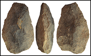
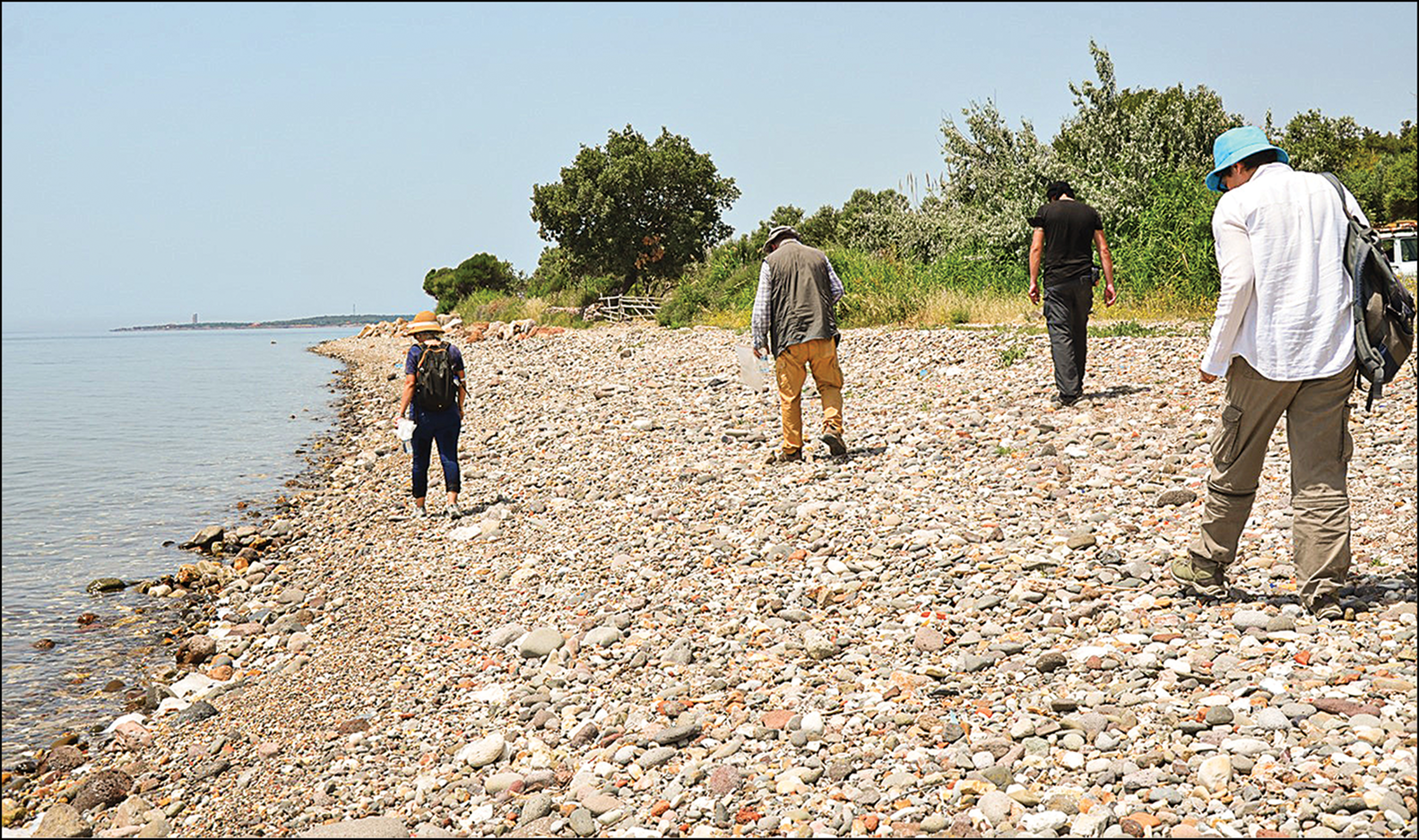
Systematic survey yielded three new open-air sites and one scattered find area (Figure 1). More than 500 Lower and Middle Palaeolithic artefacts produced from raw materials such as flint, chalcedony and quartz were obtained from these sites. Almost half (48 per cent) came from Yeşil Liman, a stony beach, with Palaeolithic materials detected among sea gravel and concentrated in a 1km2 area (Figure 2). The recovered artefacts were generally rolled by wind and tidal processes, and most displayed a white patina. The most notable items were large cutting tools (LCTs), along with trihedral picks (e.g. Figure 3), pebble core tools, flake cores (including Levallois) and various retouched tools.
Map of the research area: 1) Gemedere; 2) Kirsedere; 3) Yeşil Liman; 4) Tuzla (figure by H. Bulut; © Çanakkale-Balıkesir Survey Archive).

Pedestrian survey of the beach at Yeşil Liman (photograph by H. Bulut; © Çanakkale-Balıkesir Survey Archive).
Trihedral pick from the beach at Yeşil Liman (photograph by H. Bulut; © Çanakkale-Balıkesir Survey Archive).

Another dense findspot was found in the Kirsedere Valley, 1km north of Yeşil Liman. Covering an area of 3km2, it produced 30 per cent of the finds from the Çanakkale coastline, including a bifacial tool (Figure 4). This tool is a limande produced using greyish flint. Another tool from the Tuzla findspot (see below) is also made of greyish flint but is less rounded and can be classified as an amygdaloid (Figure 5). Both tools date typologically to the Middle Acheulean. A similar amygdaloid biface, produced from high-quality brown flint and dated to the Middle Acheulean, was found in the higher altitude area to the east, where agricultural activities currently take place.
Bifacial tool/handaxe from Kirsedere Valley (photograph by H. Bulut; © Çanakkale-Balıkesir Survey Archive).

Bifacial tool/handaxe from Tuzla (photograph by H. Bulut; © Çanakkale-Balıkesir Survey Archive).

An additional dense findspot was identified in Tuzla, in the west of the surveyed area (Figure 6). It covered 0.02km2 and produced 20 per cent of the total finds recorded. The site is an area that has thermal springs, and the surface is covered with a thin salt layer. A single bifacial tool was recorded (Figure 4). This is made of a yellowish volcanic rock and retains cortex across most of one surface, while the other is more intensively flaked; its rough, crude form suggests that it is Lower Acheulean. Several pebble core tools and Levallois cores were also recovered, along with denticulated and retouched tools that were mostly produced from large flake blanks.
Pedestrian survey of the Tuzla findspot (photograph by H. Bulut; © Çanakkale-Balıkesir Survey Archive).

The scattered findspot at Gemedere Stream produced only one Levallois core, two chopping tools and a single tested core, together comprising 2 per cent of the surveyed finds. All the lithics were exposed via a steep section, which was formed by the removal of soil that was used in modern dam construction. Although no flaked pieces were found at the top of this section, raw materials of various sizes were observed.
Discussion and conclusion
Our results demonstrate hominin occupation along the Çanakkale coastline as early as the Lower Palaeolithic. Except for the few atypical examples from Tekirdağ (Dinçer & Slimak Reference Dinçer and Slimak2007), the bifacial tools recovered compare to the most typical and well-known examples from north-western Anatolia. These bifacial tools are accompanied by other large cutting tools, pebble core tools and evidence for the Levallois technique. Although Lower Palaeolithic artefacts dominate, Middle Palaeolithic finds were recovered in smaller quantities.
The lithic assemblages from the Çanakkale coastline echo others from the Aegean Palaeolithic (Özbek & Erdoğu Reference Özbek and Erdoğu2014; Özer et al. Reference Özer2018; Sampson et al. Reference Sampson, Kabouroglou, Kaczanowska and Kozlowski2018; Erdoğu et al. Reference Erdoğu, Yücel and Demir2021), although they are techno-typologically older. The most obvious similarity is to the assemblage from Rodafnidia on Lesbos, especially considering its geographical proximity. Here, the lithic assemblage is characterised by large cutting tools, including bifaces, and prepared core technology (Galanidou et al. Reference Galanidou2016). This assemblage dates to the Late Acheulean, between 476 and 164 ka BP. The investigations along the Çanakkale coastline provide further data emphasising the importance of Lesbos as a potential dispersal route between Anatolia and Greece. Given the rich concentrations of Palaeolithic artefacts, the survey area will undoubtedly provide more data in the coming years.
Acknowledgements
The Çanakkale-Balıkesir Coastline Palaeolithic Survey Project is conducted with the permission of the Turkish Ministry of Culture and Tourism and carried out in cooperation with Düzce University and Ankara University. We would like to thank all team members for their efforts. We also owe a debt of gratitude to the two anonymous reviewers for their constructive comments.
Funding statement
This research received no specific grant from any funding agency or from commercial and not-for-profit sectors.


 Open access