


Introduction
Lomas (fog oases) are vegetation islands along the Peruvian coastal desert belt, fed by dense fog that results from the interaction between warm moist air from the Pacific Ocean and cooler, drier air currents over the Andean cordillera. The presence of archaeological sites in the lomas has led them to figure prominently in interpretations of past human–environment relationships, from early human adaptations through the development of dense populations and complex societies. Despite this research, in many ways––and especially for the later pre-Hispanic periods––lomas are treated as complementary resource zones for coastal and highland economies rather than as horizontally interconnected ecosystems (Lanning Reference Lanning1967; MacNiesh et al. Reference MacNiesh, Patterson and Browman1975; Moseley Reference Moseley1975; Rick Reference Rick and Keatinge1988; Makowski Reference Makowski2002; Canziani Reference Canziani2009; Prieto & Sandweiss Reference Prieto and Sandweiss2020).
Pedestrian archaeological surveys on the central Peruvian coast have focused on coastal valleys and have paid less attention to the comparatively remote inter-valley areas where the majority of lomas ecosystems are located. As a result, lomas sites tend to be under-represented in survey datasets, and many archaeologists have devoted little consideration to them in models of the Indigenous political economies of the late pre-Hispanic central Peruvian coast. Moreover, because archaeological studies of these areas have focused on a handful of individual sites, it is unclear how representative our existing characterisations are of lomas occupations across the central coast region.
Here, we analyse data collected via visual survey of satellite imagery using GeoPACHA (Geospatial Platform for Andean Culture, History and Archaeology), and we offer a pan-regional view of the scale and intensity of human relationships with lomas in the late pre-Hispanic (c. AD 1100–1532) and early Spanish colonial (c. AD 1532–1600) periods (Table 1). Through this approach, we characterise lomas occupations at a scale that would be difficult to achieve using traditional field-based survey methods. Satellite imagery survey is especially well suited to this task, due to the high visibility of lomas sites on the hyper-arid Andean coast (Figure 1).
View of the lomas environment (foreground) in contrast to the coastal desert beyond (photograph by Alejandro Bryce).

Schematic chronological table for the Peruvian Central Coast.

Our study documents evidence which extends the limited implications of small-scale studies of the nature, extent and functions of lomas occupations. Specifically, our findings propose a hypothesis that a humid period in the late pre-Hispanic period fostered permanent occupation within these ecosystems and that this occupation continued until early colonial times (Makowski Reference Makowski2002; Cogorno Reference Cogorno2005; Kalicki et al. Reference Kalicki, Kalicki and Kittel2014). Our analyses also provide evidence to propose and discuss five additional hypotheses: 1) that there was a distinct pattern of settlement around lomas ecosystems in the north of the Rimac Valley, in comparison to areas to the south; 2) that lomas were likely not occupied simultaneously by highland herders and coastal settlers in the later pre-Hispanic period (cf. Kalicki et al. Reference Kalicki, Kalicki, Kittel, Kalicki and Krupa2013, Reference Kalicki, Kalicki and Kittel2014; Kalicki Reference Kalicki2014), but rather by coastal peoples (following Mujica Reference Mujica, Varón and Flores1997); 3) that this pattern of coastal occupations later gave way to seasonal herding by highland populations; 4) that human occupations of the lomas ecosystem were concentrated in core areas of highest humidity and densest concentration of perennial flora; and 5) that these core areas have remained quite stable through time, persisting into the twenty-first century AD. These hypotheses arise from the pan-regional perspective afforded by systematic imagery survey but rigorous testing is not currently possible through this digital platform due to the chronological limitations of imagery-based survey. Our hypotheses are presented therefore as bases for further investigation through complementary field-based research methods.
Long-term trajectories: humans and their landscapes on the Peruvian central coast
The lomas ecosystem is the product of the interaction between marine currents, winds, Andean topography and the El Niño Southern Oscillation (ENSO) (Moat et al. Reference Moat2021). Today, these verdant island niches appear seasonally between the months of July and September when atmospheric humidity is at its peak. Ecologists and archaeologists have described lomas vegetation as a key seasonal resource for both coastal and highland populations in pre-Hispanic, historic and contemporary time periods, as well as an important context of interaction between highland and coastal groups (Patterson & Lanning Reference Patterson and Lanning1964; Lynch Reference Lynch1975; Kalicki Reference Kalicki2014; Nieuwland & Mamani Reference Nieuwland and Mamani2017; Baitzel & Rivera Reference Baitzel and Rivera2019). Herbaceous and woody plants useful for fuel, medicinal applications and dyes, as well as the wild ancestors of several cultigens (e.g. potato, tomato and squash) grow within the lomas (Dillon et al. Reference Dillon, Leiva, Zapata, Lezama and Quipuscoa2011; Beresford-Jones et al. Reference Beresford-Jones2015). Lomas also act as corridors for diverse wildlife, including wild camelids (particularly guanaco), desert fox, condor and the pampas cat (Moat et al. Reference Moat2021). Humans have long recognised and exploited these rich ecosystems; indeed, the archaeological record attests to human occupation of lomas from pre-ceramic times (c. 4500–2000 BP) until the present day, and evidence of seasonal hunter-gatherer camps and cemeteries as well as sedentary populations in the later pre-Hispanic sequence has been recovered (Engel Reference Engel1973; Mujica Reference Mujica, Varón and Flores1997; Makowski Reference Makowski, Burger and Makowski2009; Beresford-Jones et al. Reference Beresford-Jones2015).
Beresford-Jones and colleagues (Reference Beresford-Jones2015, Reference Beresford-Jones2021: 401) have, however, pointed out that the relationship between fog and lomas vegetation also varies with the ENSO cycle. The ENSO encompasses fluctuations between periods in which sea surface temperatures rise (colloquially termed El Niño) and others in which sea surface temperatures fall (La Niña). In coastal Peru, La Niña events are generally associated with reduced precipitation but more fog nearer to the shoreline (Beresford-Jones et al. Reference Beresford-Jones2021). La Niña events can thus bring changes in lomas vegetation patterns, favouring transitional areas near the shoreline, and limiting species of herbaceous annuals in core areas of the lomas (Pinto et al. Reference Pinto, Larrain, Cereceda, Osses and Schmenaur2001: 294; Beresford-Jones et al. Reference Beresford-Jones2021: 401). In the past, these oscillations could have precipitated short-term changes in subsistence strategies and settlement patterns among lomas populations.
We define the ‘core’ lomas as areas with perennial woody vegetation and a wide diversity of plant species, generally found between 500m and 800m above sea level (asl). ‘Intermediate’ areas possess a more limited range of plant species, dominated by the epiphytic Tillandsia genus, generally found between 230 and 500m asl. Finally, we define ‘ephemeral’ lomas as areas of vegetation that appear only sporadically, on an interannual basis, in the 100–230m elevation belt (Moat et al. Reference Moat2021).
As Engel (Reference Engel1973: 271) observed half a century ago, there is an almost continuous distribution of lomas in a 100–500m interfluvial elevation belt between the Huacho and Cañete Valleys (i.e. the central coast region, as defined here). By contrast, to the north of the Huacho Valley lomas are scarce, and to the south of the Cañete valley they are largely confined to isolated patches separated by broad drainages that feed into the Pacific Ocean (Engel Reference Engel1973; Beresford-Jones et al. Reference Beresford-Jones2021: 388) (Figure 2). The survey area discussed here encompasses a relatively stable and homogeneous climatic zone in terms of humidity and temperature (León Reference León2022: 66).
Schematic distribution of lomas ecosystems along the central coast (after Kalicki Reference Kalicki2014 and Moat et al. Reference Moat2021) (figure by Giancarlo Marcone).

It has been proposed that the Rímac and Lurín valleys comprise an intermediate zone that lies between distinctive lomas ecological regimes to the north and south (Kosok Reference Kosok1965: 182). In the south, between the Rimac and Cañete Valleys, lomas run roughly parallel to the coastline and encompass intermittent fluvial ravines. To the north, river courses neither parallel each other nor run perpendicular to the shoreline, and so northern lomas are distributed as more isolated green patches.
Archaeologists tended to see lomas resources as serving seasonal or marginal roles in both highland and coastal economies––that is, as sources of supplementary foods for coastal populations who focused on agriculture and marine exploitation, or as seasonal pastures exploited by transhumant highland camelid herders (e.g. Patterson & Lanning Reference Patterson and Lanning1964; Engel Reference Engel1973; MacNiesh et al. Reference MacNiesh, Patterson and Browman1975; Quilter & Stocker Reference Quilter and Stocker1983). More recently, some scholars have suggested that relationships between lomas and coastal and highland populations might be explained by John Murra's (Reference Murra1972) model of ecological complementarity, in which exchange of resources between different ecological zones is mediated not by markets but by kinship networks (Kalicki Reference Kalicki2014: 85). Other scholarship has drawn attention to variability in lomas occupation through time, particularly in relation to changing climactic conditions. Kalicki and colleagues (Kalicki Reference Kalicki2014; Kalicki et al. Reference Kalicki, Kalicki and Kittel2014; Kalicki & Kalicki Reference Kalicki and Kalicki2020) have argued that more permanent occupation of lomas correlates with periods of higher precipitation, some linked to ENSO frequency (Kalicki et al. Reference Kalicki, Kalicki and Kittel2014: 157). They contend that lomas occupation was seasonal during the first half of the Late Intermediate Period (LIP) (c. AD 1000–1200), a particularly dry phase in the sequence. In the second half of the LIP (c. AD 1200–1450), this drier than average regime shifted to one of markedly increased precipitation coeval with evidence of highland population incursions (Kalicki Reference Kalicki2014: 91; Kalicki et al. Reference Kalicki, Kalicki and Kittel2014: 158). Subsequently, during the Inka and Spanish periods, the introduction of foreign technologies and pathogens, exploitative political economies and renewed drier climatic conditions put an end to sustained settlement in the lomas (Kalicki Reference Kalicki2014: 91).
An alternative interpretation posits that lomas were occupied on a year-round basis by populations that were closely linked to coastal settlements. In this model, coastal groups adapted to lomas habitation, enhanced their economic productivity and established sedentary settlements around them (Mujica Reference Mujica1987: 7). This ‘permanent’ model of coastal occupation draws, in turn, on ethnohistorian Maria Rostworowski de Diez Canseco's (Reference Rostworowski de Diez Canseco1981, Reference Rostworowski de Diez Canseco1989) argument that late pre-Hispanic coastal societies were composed of distinct, specialised economic segments that exploited specific ecosystems––in the case of the lomas, an ethno-political group called the Caringas (see also Eeckhout Reference Eeckhout2004). In turn, the Caringas were part of a larger network of coastal agricultural and fishing communities known as the Ychsma polity (Rostworowski de Diez Canseco Reference Rostworowski de Diez Canseco1981; Mujica Reference Mujica, Varón and Flores1997: 200). To differentiate it from Murra's emphasis on ‘vertical’ connections between social groups distributed across ecological tiers in the mountainous Andean landscape (Murra Reference Murra1972), this interpretive focus on intra-coastal interaction is sometimes referred to as the ‘Horizontal Model’, and it has been extended to other regions (e.g. Shimada Reference Shimada, Millones and Tomoeda1982; Zaro Reference Zaro2007; Pacifico & Johnson Reference Pacifico, Johnson, Johnson, Pacifico and Cutright2021).
During the late 1980s and early 1990s, Mujica and colleagues started reconnaissance of lomas ecosystems between the Lurín and Chilca valleys (Mujica Reference Mujica1987) and later conducted excavations in the dry quebrada of Malanche (Mujica et al. Reference Mujica, Baraybar and Bolaños1992; Mujica Reference Mujica, Varón and Flores1997). Based on this research, they proposed that year-round occupation was possible in part because of the development of complex systems of water collection and subsoil water harvesting (canals, dikes, wells) for limited agriculture activities (on terraces), complemented by foraging and herding (Mujica Reference Mujica, Varón and Flores1997: 208–10). In this model, herding was present in these settlements, but as a complementary activity to local occupations and was not part of highland seasonal rotation patterns. The oscillation between El Niño and La Niña events likely required diverse subsistence strategies in neighbouring ecological zones to sustain year-round occupations. Mujica proposed that the occupation of Malanche lasted from the thirteenth or fourteenth century AD until early colonial times (Mujica Reference Mujica, Varón and Flores1997: 203).
Scholarship by Krzysztof Makowski has contributed another level of complexity to the discussion of lomas occupations, as he argues that the Lurín Valley settlement of Pueblo Viejo was perennially settled only when it was occupied by a colony of highland mitmaqkuna, a group of forced migrants strategically resettled in the area by the Inka in the fifteenth century AD (Makowski & Oré Reference Makowski and Oré2013: 517; Castillo & Makowski Reference Castillo and Makowski2019). In contraposition with the transhumant models, Makowski contends that it was only during the era of Inka imperialism that highland peoples came to occupy the site year-round, and Pueblo Viejo was abandoned following the Spanish invasion and the collapse of the Inka empire (Makowski & Oré Reference Makowski and Oré2013: 519). Indeed, contrary to the evidence reported at Malanche, there is no evidence of colonial occupation at Pueblo Viejo (Makowski Reference Makowski2002: 141).
Thus, there are two main interpretive framings of late pre-Hispanic occupations of the lomas ecosystems. One emphasises vertical interaction with lomas featuring as a peripheral zone for both coastal and highland populations, suggesting fluid interactions between these populations who each, separately, exploited these ecosystems. A second emphasises horizontal interactions among coastal groups and year-round occupations. Both approaches are based on two assumptions. First, that permanent (year-round) occupation in the area was only possible during the period of increased humidity during the first half of the LIP (c. AD 1100) through to early colonial times. And second, that lomas distributions throughout the central coast are regular and uniform; less attention is given to how ecological variation within and across lomas patches might have influenced the roles they played within regional political economies.
These assumptions are based on results from fragmentary field research; intensive archaeological research at lomas sites has focused on a very small number of locations. Findings from these locations have then been used to generate general hypotheses about lomas occupations. We argue that to properly test the validity of these interpretive frameworks new sources of data are needed which span the diversity of lomas across the central Peruvian coast, as well as adjacent regions. Large-scale imagery survey enables such a broadened perspective.
Patterns in the human occupation of lomas
The GeoPACHA project enables visualisation of high-resolution satellite imagery from multiple sources (including Google Maps, Bing Virtual Earth, ESRI high-resolution imagery and MapBox) and the systematic survey of large areas through a grid-based tracking system (see Wernke et al. Reference Wernke2023, for details of the GeoPACHA project). To assess variation in lomas occupation, we employed GeoPACHA to conduct a systematic satellite imagery survey of archaeological loci (features of archaeological interest) within a portion of the inter-valley zone of the Peruvian central coast. The hyper-arid characteristics of the central coast are ideal for this kind of imagery-based feature detection and we surveyed an area of almost 8800km2 stretching from the southern edge of the Huaura Valley in the north to the northern edge of the Cañete Valley in the south (Figure 3). These boundaries are historically meaningful as they map the extent of the Lima culture of the Early Intermediate Period (c. 200 BC–AD 700) and the Chancay and Ychsma societies of the Late Intermediate Period (c. AD 1100–1470) and Late Horizon (c. AD 1470–1531). We started our survey from the southernmost border of the project area and worked northwards, tagging (with a single point) each relict anthropogenic feature visible in the satellite imagery. We used an arbitrary 100m rule to define locus boundaries––that is, any feature located greater than 100m from its nearest neighbour was considered a separate locus and features less than 100m apart were grouped together as a single locus. In total, 1018 discrete archaeological loci were identified, most within a low elevation band that stretches across the inter-valley plains and foothills, extending inland about 30km from the coast. Of these, 342 loci are in areas with evidence of past or present lomas ecosystems.
Survey area in the central coast showing loci identified in lomas ecosystems (figure by Giancarlo Marcone).

For the purposes of this article, we focus on spatial patterns within the valleys, mostly in the foothill areas. The concentration of loci within the foothills at the same altitude that lomas are typically found would seem to suggest that these sites represent the remains of lomas occupations. To test this observation, loci locations were compared with lomas distribution mapped by Moat and colleagues (Reference Moat2021), based on analysis of 20 years of MODIS satellite imagery (2000–2020) and complemented with assessment of vegetation productivity through the Normalised Difference Vegetation Index (an estimation of the density of green coverage within an area; Figure 4). Moat and colleagues mapped 17 000km2 of extant lomas and categorised them using six classes. Class 1 represented ephemeral lomas while class 6 represented core areas of highest and most sustained humidity with herbaceous and woody land cover. Multiple lines of evidence––including lithic flux in marine sediments (Rein et al. Reference Rein, Luckge, Reinhardt, Sirocko, Wolf and Dullo2005) and proxies in sediment cores from Laguna Paucallcocha (Moy et al. Reference Moy, Seltzer, Rodbell and Anderson2002)––indicate a period of higher humidity in the central coast region during the early LIP, linked to intensified El Niño events (Kalicki Reference Kalicki2014: 88). Archaeologists have struggled to relate this climactic pattern to changes in settlement patterns, however, and it has been unclear if settlement distribution expanded during this period and/or if any changes arose in the seasonality of local occupations. To assess whether pertinent patterns may be discerned within our data, we compared the distribution of archaeological loci identified in GeoPACHA with the extent of six classes of lomas ecosystem identified by Moat and colleagues (Reference Moat2021).
Locations of archaeological loci in relation to lomas distributions. Lomas areas based on Moat et al. Reference Moat2021 (figure by Giancarlo Marcone).

A Monte Carlo simulation was used to test whether the observed distribution of loci was significantly different from a random distribution with respect to the lomas categories proposed by Moat and colleagues. This simulation repeatedly distributes points across the study region and compares the randomly generated distribution to the observed distribution of loci. The null hypothesis, that there is no relationship between the location of loci and lomas persistence within the survey zone, must be accepted if the randomly generated points are distributed between areas of different lomas classes at approximately the same rates as the recorded loci. If the distribution is concentrated in a particular area, the null hypothesis will be rejected, and the relation between loci and specific class in Moat et al. distribution proved.
Results
Analysis of the distribution of archaeological loci identified in the survey area demonstrates notable differences between those lomas areas located south of the Rimac Valley and those located to the north (Figure 2). Within the 4265km2 area surveyed south of the Rimac Valley, 1768km2 of lomas ecosystem was mapped and 243 loci were identified within the lomas. North of the Rimac Valley, 1438km2 of the 4535km2 area surveyed was identified as lomas ecosystem and contained 101 loci. This difference may relate to the lomas distribution itself and to variations in the geomorphology of the coastal belt. North of the Rimac Valley, lomas are present as green pockets isolated from valleys but, to the south, between the Rimac and Cañete valleys, lomas form an almost continuous vegetation band that runs parallel to the coastline and perpendicular to valleys and dry ravines (quebradas).
The survey showed that two general types of archaeological loci are found in lomas areas (Figure 5). The first are large, isolated structures we call corralónes (large corrals), which previous archaeological field research suggests were used by pastoralists as overnight pens for camelids (Mujica Reference Mujica, Varón and Flores1997; Kalicki Reference Kalicki2014). These structures are easily identifiable from the satellite images as high fieldstone walls enclosing large areas (ranging between 100 and 200m2 approximately) (Figure 6). A second type of locus is composed of agglutinated structures of different sizes, with walls in such a poor state of preservation that they are much harder to discern in satellite imagery. The poor state of preservation is likely due to their older age relative to corralónes. This second type of structure may be linked with late pre-Hispanic occupation (Figures 7 & 8).
Examples of isolated structures or corralónes identified on satellite imagery (images from Google Earth 2022 CNES/Airbus; figure by Giancarlo Marcone).

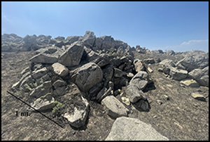
An example of a corralón at ground level (photograph by Alejandro Bryce).

Satellite images of Malanche dried waterway structures, as an example of agglutinated structures identified in lomas ecosystems (images from Google Earth 2022 Maxar Technologies; figure by Giancarlo Marcone).

Examples of small structures at ground level during dry season (photographs by Giancarlo Marcone).

Comparison of the distribution of archaeological loci identified through GeoPACHA with the extent of the six classes of lomas identified by Moat and colleagues (Reference Moat2021) shows a clear tendency for loci to be concentrated principally in areas of greater humidity (Figure 9). Table 2 presents the percentages of lomas areas comprised by each class and the percentage of loci found in each of these zones. The greatest proportion of loci identified by our survey were found in association with the areas of greatest biomass and herbaceous, woody plant cover (class 6).
Distribution of loci and lomas classes. Class 6 represents lomas which persist more than 50 per cent of the year, while class 1 are ephemeral oases which are present for less than one week per year. See Table 2 for further information (figure by James Zimmer-Dauphinee).

Locus distribution by lomas area (classification following Moat et al. Reference Moat2021).

To further test the significance of loci distribution, a Monte Carlo simulation was conducted with 100 000 iterations and generated a significant result with a p value of 0.00002. This indicates that only two out of the 100 000 random point patterns were as extreme, or more extreme, in their split between lomas classes than the observed pattern of loci. The null hypothesis is therefore rejected and a strong association between identified loci and the contemporary extent of lomas vegetation is proposed. This suggests that most of the core vegetation areas will have been relatively stable for some time, as they are driven by the unimodal winds and the Humboldt current (a cold-water current that flows north from Antarctica along the west coast of South America). As a result, we suggest that, in aggregation, late pre-Hispanic occupations were preferentially situated within perennial herbaceous and woody fog oases and did not become more dispersed during the early LIP. Rather, settlement location remained stable, and an intensified, year-round occupation of lomas was supported by horticulture and complementary herding.
Notes for a chronological discussion
One of the greatest limitations of satellite survey in archaeology is the inability to acquire clear chronologies in the absence of sites with distinctive features that have themselves been dated using other techniques. Fortunately, previous archaeological field research on lomas sites provide us with a means of estimating the chronologies of the loci identified in this study.
Most pre-ceramic sites (dating to before c. 1800 BC) within the lomas are seasonal camp sites, with little apparent surface architecture (e.g. Patterson & Lanning Reference Patterson and Lanning1964; Engel Reference Engel1973; Beresford-Jones et al. Reference Beresford-Jones2021). In the Lachay region (see Figure 2), this pattern of occupation continues more or less unchanged during the Early Horizon (c. 800–200 BC), with the exception of the appearances of an isolated public building (Kalicki et al. Reference Kalicki, Kalicki and Kittel2014: 155). Similar dynamics are reported for the Lurín Valley, where isolated ceremonial centres serve as indicators of dispersed communities living close to their catchment areas (Burger Reference Burger and Seki2014). By the end of this period, some cemeteries are also reported in the lomas (e.g. Makowski Reference Makowski, Burger and Makowski2009). These early camp and cemetery sites are not likely to be represented in our survey.
For the subsequent Early Intermediate Phase (c. 200 BC–AD 700), occupation structures composed of single-coursed walls associated with agricultural terraces are reported at Lachay (Kalicki et al. Reference Kalicki, Kalicki and Kittel2014: 155). In the southern part of our survey area, no Early Intermediate Phase sites have been reported in a lomas context, although several sites do exist within valleys at comparable altitudes to lomas ecosystems––for example, the site of Lote B in the Lurín valley (Marcone Reference Marcone and Murphy2016). For the Lachay area these Early Intermediate Phase sites could have been re-occupied during the LIP as well (Kalicki et al. Reference Kalicki, Kalicki and Kittel2014). Therefore, although there is some suggestion of year-round occupation of the lomas in the Late Intermediate Period, lack of investment in architectural materials and the fact that many sites were later re-occupied, indicates that there is an under-representation of Early Intermediate sites within identified loci.
The Middle Horizon (c. AD 600–1000) is a period of population contraction throughout the central coast, and lomas ecosystems are no exception. No lomas sites have been reported for the Middle Horizon, with the exception of cemeteries such as Teatino in Lachay (Kalicki et al. Reference Kalicki, Kalicki and Kittel2014: 156). By the LIP, however, several sites are reported in the lomas (Mujica Reference Mujica1987, Reference Mujica, Varón and Flores1997; Kalicki Reference Kalicki2014). These complex sites include extensive agglutinated domestic areas, storage, terraces and other architectural features which suggest year-round occupations, and are clearly identifiable from the satellite imagery. We therefore propose that most loci showing agglutinated structures identified within our survey date to the LIP. Some may also correspond to subsequent Late Horizon occupations from the fifteenth century AD. Small temporal differences (which could be less than 100 years) between the LIP, Late Horizon and early colonial era are only possible to address in relation to specific intra-site studies (e.g. Makowski Reference Makowski2002). These studies in general support the idea of a strategic (though indirect) Inka intrusion in the central coast, through neighbouring highland people (Makowski & Ore Reference Makowski and Oré2013).
The other type of structure recognised in our survey is the corralónes used for pastoralist activities. These structures are generally rebuilt on a seasonal basis, which makes them particularly easy to identify in our survey but very difficult to date. We hypothesise that most of these isolated structures are post-conquest constructions, but this initial assumption needs to be corroborated by future field research.
Discussion: some regional views of lomas ecosystem occupation
The regional view provided by our survey extends the idea of a year-round occupation of the most productive and perennial core areas of lomas during the early part of the Late Intermediate Period, which corresponds with a period of increased humidity along the Peruvian coast (Moy et al. Reference Moy, Seltzer, Rodbell and Anderson2002; Rein et al. Reference Rein, Luckge, Reinhardt, Sirocko, Wolf and Dullo2005). From our pan-regional satellite imagery survey, we propose that past human occupation of the lomas concentrated in the core areas of this ecosystem (Figure 9) and that these core areas have remained quite stable through time, persisting to the present day.
A review of field research in the survey area indicates that structures identified in our survey likely date from the LIP or later. Among the loci we were able to identify two types of structures. Those possibly relating to herding (corralónes) appear to be more recent, or at least to have been maintained more regularly, than the complexes of agglutinated structures we also identified, which were apparently abandoned prior to the appearance of the tradition of corralónes construction and remain in a poor state of preservation.
The differences in the distribution of archaeological loci we have identified in the lomas between the northern part and southern part of the central coast could help to explain why research from Lachay, in the northern extent of our survey area, supports the transhumance model, where highland herders and coastal settlers in late pre-Hispanic times shared access to lomas (Kalicki et al. Reference Kalicki, Kalicki, Kittel, Kalicki and Krupa2013, Reference Kalicki, Kalicki and Kittel2014; Kalicki Reference Kalicki2014). Research from more southern areas proposes that late pre-Hispanic occupation was permanent and in direct interaction with coastal developments (Mujica Reference Mujica1987, Reference Mujica, Varón and Flores1997; Makowski & Oré Reference Makowski and Oré2013). In this sense, Pueblo Viejo (the Inka era settlement discussed above) could be the exception that confirms the rule. The presence of highland communities in the region seems to have been facilitated by the Inka state; it was not the result of a long-term or ‘organic’ settlement radiation from the highlands prior to Inka rule (Mujica Reference Mujica, Varón and Flores1997; Makowski & Oré Reference Makowski and Oré2013). In this southern portion of our study area there are no purported permanent settlements of highland populations other than Pueblo Viejo. This idea is also supported by the ethnohistoric data, which suggest that southern lomas were occupied by the Caringas Ayllu, part of the Ychsma coastal society (Rostworoski de Diez Canseco Reference Rostworowski de Diez Canseco1989).
Conclusions
The study of lomas settlements through imagery survey in GeoPACHA provides regional perspectives that, when compared with previous field research, produce a series of refined hypotheses about the human occupation of the central coast of Peru. As Wernke and colleagues argue in their overview of the GeoPACHA project (Werneke et al. Reference Wernke2023), archaeological hypotheses concerning large-scale phenomena are often generated (and then tested) based on very limited samples. A critical first step to improving large-scale archaeological research is therefore to generate hypotheses for testing based on initial observations of large-scale systems. This article provides that first step and continues the discussion surrounding variation within the spatial distribution of lomas and hypotheses of human occupation within these ecosystems. Testing these hypotheses will require additional systematic pedestrian survey and excavations designed to sample the variation in lomas occupations identified by our satellite survey.
By highlighting an apparently long-term association between substantial settlements and perennial herbaceous and woody fog oases, this study suggests that it may be productive to think of lomas not as inveterately transitional, liminal or ‘complementary’ resource zones located between coastal and highland societies—at least during the Late Intermediate Period.
In this way, our large-scale imagery survey has generated both new insights and new questions for continued field investigation in both the northern and southern parts of the central Peruvian coast. As lomas ecosystems are threatened by climate change and development, these research efforts are an urgent priority for understanding the long-term history of this part of Andean South America.
Funding statement
The survey of the central coast was possible through the financial support of the Center for Impact and Social Responsibility (CIRSO) of the Universidad de Ingenieria y tecnologia (UTEC). GeoPACHA was supported by grants from NEH, ACLS, SPARC, Vanderbilt University, Brown University Dean of Faculty, and a Stanley J. Bernstein Assistant Professorship in the Social Sciences.


 Open access