


A declining commercial metropolis
Between the late thirteenth and late fifteenth centuries, the Flemish city of Bruges served as the main commercial hub of north-western Europe. An urban centre of some 50,000 inhabitants with access to the North Sea, it hosted more foreign merchants than any other city north of the Alps. Organized in ‘nations’, or foreign merchant guilds, traders from Venice, Genoa, Florence and other Tuscan cities, numerous Hanseatic towns, England, Scotland and the various kingdoms of the Iberian Peninsula supplied commodities from the North Sea area, the Mediterranean and the Orient. At the same time, Bruges functioned as a ‘gateway city’ for the Low Countries’ industrial exports, most notably those of the textile industry. What particularly appealed to the merchant community was the city's numerous open-access institutions, facilities that could be used indiscriminately by all traders. Modern economic theory claims that these institutions kept transaction costs – the expenses incurred while making an economic exchange – low.Footnote 1 According to Oscar Gelderblom, the urban authorities developed an institutional regime that made it more attractive to trade in Bruges than in competing cities.Footnote 2 Mostly recruited from the local commercial elites, Bruges’ aldermen provided a specialized court system that limited merchants’ policing and enforcement costs, or the costs of ensuring contractual compliance. The city also invested in commercial infrastructure, such as halls, weighing houses and cranes, operated by porters and dockworkers, and made them available to traders. Other parties complemented the city government's efforts. The foreign nations and the central authorities organized jurisdiction subsidiary to that of the urban courts. Search and information costs were kept under control by the use of hostels, where the Bruges hostellers accommodated visitors and merchants met to strike business deals. Locals also acted as brokers or intermediaries between foreign traders, allowing them to conclude transactions for reasonable bargaining costs.Footnote 3
Over the course of the fifteenth century, however, Bruges lost much of its allure. During the 1430s, international merchants were already leaving the city for months in order to visit the yearly fairs in nearby Antwerp and Bergen op Zoom.Footnote 4 Falling revenues from commercial tolls show that the numbers of foreign visitors to Bruges started to dwindle during the 1460s.Footnote 5 Decline had set in, and after banning the sale of English cloth in order to protect the Flemish textile industries, Bruges failed to secure the presence of both the Portuguese with their rapidly expanding Atlantic trade and the South Germans with their booming metal business.Footnote 6 Finally, a succession of popular revolts during the 1480s against Archduke Maximilian of Austria, ruler of the Burgundian-Habsburg Low Countries, and their resultant repression, delivered an even more severe blow to the city's predominance and made increasing numbers of foreign merchants depart for Antwerp.Footnote 7
Bruges’ urban authorities did everything they could to make their city more attractive. After protectionist measures proved unsuccessful, they tried to counter the exodus and lure merchants back by lowering transaction costs even further. In 1470, the aldermen agreed to pay an annual sum to the central government to exempt all Scottish merchants, whose wool supply became increasingly important to the Low Countries, from ducal tolls on the waterways that led to the city. In 1479, following a similar decision by Antwerp, they convinced Maximilian of Austria to stop collecting tolls from all foreign visitors in return for a lump sum. Two years later, the city purchased the right to impose the so-called ‘great toll’, held by the noble Van Luxemburg family, so it could control the tariffs itself.Footnote 8 After the disruptions of the 1480s, Bruges stepped up its efforts. In 1493, new and significantly more extensive commercial privileges were granted to the Italian and Catalan traders, while a small group of Sicilian merchants was given trading rights for the first time. During the last decades of the fifteenth and the first decades of the sixteenth centuries, new nation houses were built for – or at least promised to – the Portuguese, the Castilians, the Catalans, the Biscayans and the Navarrese.Footnote 9 The lower tolls, more extensive privileges and free infrastructure were all geared towards making trading in the city less expensive.
The navigability of the waterways around Bruges was a problem that went back much further in time than the early fifteenth century.Footnote 10 The city owed much of its prosperity to its connection to the sea, but accessibility was difficult to ensure. Bruges sat on the edge of the ever changing landscape of the Flemish coastal plain, which was constantly affected by natural factors such as sea tides, occasional storms and the silting up of existing streams and gullies, as well as by the construction of dykes, land reclamation and other forms of human activity.Footnote 11 Around the middle of the twelfth century, a series of storm surges created the Zwin, a tidal channel that provided Bruges with a direct connection to the sea. In subsequent centuries, the waterway became the city's main commercial artery, along which most goods from abroad were imported. Yet the Zwin estuary was not sufficiently fed by inland rivers and began to silt up almost immediately.Footnote 12
As a result, the city struggled to maintain its maritime accessibility. Investments in canal maintenance already appear in Bruges’ earliest accounts, which date from the end of the thirteenth century. During the fourteenth and fifteenth centuries, several attempts were made to deepen and straighten the course of the Zwin between Bruges’ smaller outports of Damme and Sluys. From the 1360s onwards, projects were carried out to increase the canal's flow rate in order to scour it naturally. Pilots employed by the city helped shipmasters avoid sandbanks, beacons and buoys were set up and masts were placed in the dunes. In 1456, a signal system for ships was installed. Yet the problems continued and began to impact merchants’ transaction costs. Big ships, which had enabled the fast and cheap transport of large cargoes, avoided the Zwin. Goods arrived late, or were lost in shipwrecks. By 1500, the sandbanks at the entrance of the Zwin had become so large that only small ships could still enter it.Footnote 13
With the support of the prince, the urban authorities made structural investments to remedy the situation. In 1470, Bruges developed a master plan to improve the navigability of its waterways to the sea. The aldermen initiated major hydraulic works, such as the construction of the Zwarte Gat polder dyke, which utterly failed. At the beginning of the sixteenth century, Bruges hoped that the construction of the Oostburg Canal, or Nieuw Gedelf, between Sluys and the Western Scheldt, would solve the problems. Started in 1500 and finished in 1516, its objective was to reduce the silting-up of the Zwin by intensifying the erosion caused by tides. Its effects, however, were minimal. Inside the city, a new lock complex (the so-called Drie Deuren) was constructed between 1519 and 1522 to funnel water from the countryside into the city centre. By deepening the canals, repairing the quaysides and clearing the streets of stoops and cellar stairs, more modest attempts were made to stimulate water traffic. Finally, between 1548 and 1566, yet another canal, the Verse Vaart, was dug between Sluys and Bruges, accompanied by an impressive lock complex. Although initially these hydraulic works met with some limited success, in the long run, the city's efforts were in vain. Bruges’ accessibility only declined further. Foreign merchants left for good and even native traders tried their luck elsewhere. By 1560, Antwerp had taken over Bruges’ role as the leading centre of trade in north-western Europe.Footnote 14
A commercial ideology in texts and images
While recent historiography has downplayed its importance in favour of economic and political factors, contemporaries certainly perceived waterway navigability as the primary cause of Bruges’ undoing.Footnote 15 The conviction that this maritime connection constituted Bruges’ lifeline to the world was part of a normative discourse on what type of economic policies should be carried out. Unlike many other places,Footnote 16 this discourse was not one limited to the urban elites but was present throughout the city's occupational groups. Calls for material alterations to the port infrastructure were mostly made by the commercial elites – brokers, hostellers and merchants from the city itself. Yet petitions from the urban middle groups, consisting of small commodity producers and retailers, also emphasized the need for a stable investment climate, physical and legal security for foreign merchants and efforts to keep the Zwin estuary accessible. In 1436, for instance, the deans of the craft guilds, who were in open rebellion against the elites and the Burgundian duke, demanded measures to boost the urban economy, including the improvement of the Zwin's navigability.Footnote 17 Whether in princely or urban charters, Flemish chronicles or diplomatic correspondence, Bruges was stereotypically represented as ‘the principal port of Christendom’, and only reachable via the Zwin. The urban space was thus ideologically conceived as a place of wealth and abundance facilitated by its accessibility from the water and the hospitality and legal security offered to foreign merchants.Footnote 18 The debates about the city's economic crisis from the final quarter of the fifteenth century onwards offer an excellent occasion to study such economic concerns and ideological expressions, in both textual and visual source materials.
Indeed, the earliest preserved depictions of the city and its immediate environment date from the same period in which this discourse emerged. ‘Maritime and commercial iconography’ or ‘hydrographic city views’ in miniatures and panel paintings have already received much scholarly attention.Footnote 19 The famous crane of Bruges, standing in the Kraanplaats or ‘Crane Square’, for instance, was depicted in four versions: Hans Memling painted it in a detail of the Mystical Marriage of Saint Katherine in 1479; Simon Bening included a miniature of it in a book of prayers with a Flemish Calendar c. 1525; an anonymous Bruges artist painted it as a detail in Filips Dominicle's portrait c. 1550; and Pieter Pourbus painted it in the background of Jan van Eyewerve's portrait in 1551.Footnote 20 The pendant portrait of van Eyewerve's wife also features elements of portuary, or hydraulic infrastructure, such as the Minnewater, the Sashuis and the Minnewater bridge.Footnote 21 The Seven Miracles of Bruges (c. 1550–60), a painting attributed to Pieter I Claeissens, depicts an idealized image of the city, its magnificent architecture and state of the art facilities. Pride of place was given to Bruges’ commercial infrastructure, including the Water Hall, where merchants unloaded the goods from their ships while protected against the weather.Footnote 22
By the end of the fifteenth century, growing numbers of cartographic documents also began to appear. References to public expenses for the production of maps and views multiplied during this period and their ownership is more frequently documented in inventories,Footnote 23 suggesting an increasing spatial literacy among the city's inhabitants. Still, Bruges’ cartographic representations have thus far received less scholarly attention than the aforementioned iconography of the Northern Renaissance.Footnote 24 These maps showcase the city's port infrastructure, internal hydrography and sea connections, elements of the same type of ‘commercial ideology’ expressed in written discourse. At first glance, it might seem ironic that ever more splendid maps and views of the city were produced precisely when Bruges was in decline and its importance as a port was diminishing. Historians have explained this apparent contradiction by highlighting the propagandist purposes of the maps’ commissioners. When discussing a 1562 map of Bruges produced by Marcus Gerards, Ryckaert and Vandewalle argued that it was part of a ‘propaganda campaign’ to revitalize commercial life in the city and attract new merchants.Footnote 25 Similarly, an anonymous drawing of the waterways inside and outside Bruges’ city centre has also been interpreted as ‘publicity material’.Footnote 26
Use of the word ‘publicity’ could be taken to mean that a clear juxtaposition existed between maps depicting the ‘real’ urban space, and images with supposedly propagandist objectives. In actuality, every map is inevitably an interpretation, a subjective perception of a landscape, an ideological discourse on the space it depicts.Footnote 27 Every cartographic image displays a field of tension between the real, material landscape or ‘physical space’ on the one hand, and the ideological frames of reference shared by its producers and audience on the other. Kain and Oliver stated that, ‘much more than mere mirrors in which the physical reality of the past is reflected’, maps ‘can be read as “texts” in the same sense that paintings, film and theatre can’.Footnote 28 Naomi Miller even goes so far as to call maps ‘fictive creations’, inherently marked by selection, bias and distortion.Footnote 29 They can display memories, pride or identity, as well as power, fear, hope or confidence. The French sociologist Henri Lefebvre considered both textual and visual representations of urban space a ‘conceived space’, one framed in a ‘discursive regime', a specific ideology. Thus, politicians, entrepreneurs and the engineers and architects in their service ‘construct’ cities materially as well as ideologically. Footnote 30
This also applies to the visual spatial representations of later medieval and early modern Bruges, as is attested to by the surviving cartographic documents. The growing number of maps produced in late fifteenth- and sixteenth-century Bruges influenced their intended audience. Yet, the dominant and often institutionalized discourses on space were already present in the mind-set of the artists and engineers that drew them and the merchants and politicians who conceived them. They cannot be reduced to acts of conscious ‘propaganda’, nor did they have purely ‘functional’ or ‘practical’ purposes. Instead, we argue that the iconographic language of these documents should be considered as a specific form of Lefebvrian ‘represented’ or ‘conceived space’. Just as the textual sources did, they expressed the city's economic ideology of an open and accessible market. In this discourse, a hegemonic one shared by the city government, merchants and artisans, the creation of favourable conditions for investment and international trade was considered one of the duties of any prince or urban council, an aspect of justice, common profit and good governance itself. In line with Lefebvre's conception of space as both socially produced and socially productive, the maps under consideration here both reflected and further projected this agenda.
Mapping a commercial ideology
Public investments made to map the city, its hydrographical situation or the Zwin estuary are documented in the Bruges city accounts. The oldest traces of expenses for cartographic material date back to the early 1470s, when a certain de Visscher was paid to produce a map of the Zwin.Footnote 31 Then, between 1480 and 1483, the urban authorities paid painter Jan Fabiaen for one or several maps that ‘had to show the city's hydrography’.Footnote 32 These included payments for ‘two plans made and designed by him of the canals, sewerages, moats and other waterways of this city’.Footnote 33 Unfortunately, these fifteenth-century maps have not survived, but it is obvious that the city's earliest investments in cartography were connected to the state of its hydrography. This is rather unusual, as the oldest European city maps are often assumed to have had military purposes.Footnote 34 In Barcelona and many Italian cities, including Genoa and Pisa, for example, military expeditions lay behind the creation of the first cartographic documents. Harbour facilities and waterway infrastructure only became a central theme during the eighteenth century.Footnote 35 Venice, where the state of the marshy lagoon was equally crucial to the city's survival, is one of the few places where a similarly close relationship between cartographic and hydrographic projects has been attested to as in Bruges There, the earliest city maps were produced by officials in charge of regulating the waterways.Footnote 36 In Bruges, the authorities employed similar officers,Footnote 37 but none of the extant maps can be attributed to them.Footnote 38 Instead, the mapmakers were private painters, builders and land surveyors contracted by the city authorities.
Unfortunately, most expenses relating to cartographic material in the city accounts refer to maps that have since vanished. Only a few of the maps preserved in museums and the Bruges city archives can be linked to these financial records. In most cases, the archival context of the extant maps has been lost due to their transfer to separate cartographic collections in the course of the nineteenth and twentieth centuries.Footnote 39 This makes it difficult either to date them precisely or to make firm hypotheses regarding their original purposes. They are quite different in terms of typology, projection, size, topographic content, scale and style, but, as was the case with the earliest maps, they all strongly emphasize the hydrographic situation of both the city and its immediate surroundings and are informed by a common iconographic and ideological programme. Based on the relationship between the hydrography depicted and other topographic elements, we have categorized the oldest extant maps in a way not fully attempted before. We distinguish three main groups: (1) maps that depict Bruges as part and terminus of a complex water network emphasizing the city's accessibility; (2) technical maps and design plans proposing improvements or alterations to the existing water infrastructure; (3) maps focusing on the city of Bruges, its hydrographic infrastructure and its port facilities.
Bruges as the terminus of a transport network (map type 1)
In the ideally represented urban commercial space, Bruges’ attractiveness as a hub for international trade was inextricably linked to the city's accessibility from the sea. That is also the central message of three maps produced in Bruges during the second half of the fifteenth and first half of the sixteenth centuries. The oldest map was inserted into a handwritten Italian translation of the ‘Excellent chronicle of Flanders’ (‘Excellente Cronicke van Vlaenderen’), dated 1452, and is the oldest extant map of Flanders (see Figure 1).Footnote 40 Elsewhere in Europe, the earliest cartographic depictions of towns and cities were often part of literary works as well.Footnote 41 The translation of the ‘Excellent Chronicle’ seems to have originated in a circle of Italian merchants and bankers operating in Bruges around the middle of the fifteenth century. As indicated in the text's prologue, the map served ‘to better understand the history and territory of Flanders’.Footnote 42 As such, it was clearly not intended to provide an accurate depiction of the county's and city's topographical situation, but rather to provide readers with a rough guide to the myriad of places figuring in the chronicle.
Oldest extant map of Flanders, inserted in the ‘Cronache de Singniori di Fiandra e de Loro Advenimenti’, 1452, Bruges, Public Library, MS 685, fols. 211v–212r.

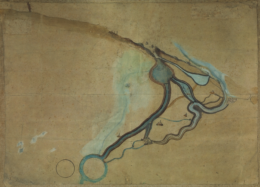
The second map was made by the Bruges painter Jan de Hervy in 1501, and was commissioned by the Bruges city council (see Figure 2).Footnote 43 The city accounts of 1501–02 record a payment to de Hervy for ‘rendering in portraiture in oil colours the new canal and other things’.Footnote 44 His map shows the excavation works for the construction of the Oostburg Canal, or Nieuw Gedelf, which, connecting the Zwin mouth to the Honte waterway, was intended to resolve the estuary's silting by increasing its water supply.
Map of the Zwin area by Jan de Hervy, 1501, Bruges, Groeninge Museum, inv. O.1382.
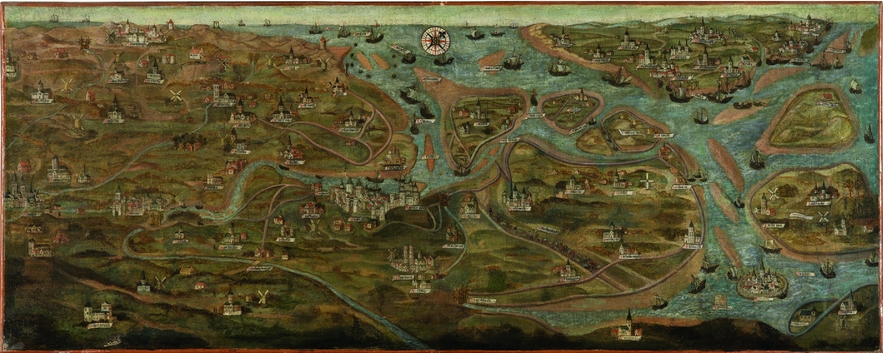
The easy and direct accessibility of Bruges via the sea is the central theme of both maps. As many other late medieval city views,Footnote 45 the rudimentary 1452 map portrays Bruges in a synoptic way: it focuses disproportionately on those elements that are characteristic to the city and make it unique. Tellingly, its most striking feature is the ubiquity of water. In the painting by de Hervy, the new canal is included as an integral part of the complex water network stretching from the Scheldt River on the right, to the port of Bruges on the left. In order to emphasize the city's maritime accessibility, proportions and relative distances have been modified, and numerous ships are shown navigating the waters. It was not the painter's task to depict the finished Nieuw Gedelf, which was not completed until 1505, but rather to communicate the city's efforts to improve the amenities for deep water vessels. The landscape around the city was not depicted accurately, but what mattered was the ideologically inspired portrayal of an attractive market with a navigable waterway.Footnote 46
Bruges as the terminus of a transport network is also the main theme of a third map, traditionally called the city's ‘Oldest Painted Town Plan’ (see Figure 3).Footnote 47 On stylistic grounds and architectural details, the anonymous bird's-eye view should be dated to the first half of the sixteenth century, probably around 1540,Footnote 48 but it is clear that some portions were later repainted. The plan is likely to have been part of a larger painting showing the Zwin estuary, the outports of Damme and Sluys and the first stage of the Verse Vaart.Footnote 49 Contrary to the other maps, the ‘Oldest Painted Town Plan’ provides a detailed depiction of the urban territory intra muros, among which the city's hydrography stands out. Particularly striking is the large basin where high tonnage sea ships are moored in the bottom left corner (see Figure 4), situated within the city walls, near the Dampoort gate complex, where the waterway to the sea met Bruges’ inner canals. Near the basin, there is a broad canal between the Dampoort complex and the Augustijnenrei, another Bruges waterway. It has seven wooden draw-bridges and an impressive portage that would have allowed ships to reach the city centre. The basin and the canal are connected by a large stone quay and plaza.
‘Oldest Painted Town Plan’ of Bruges, probably around 1540, Bruges, Groeninge Museum, inv. O.410.

Detail of the ‘Oldest Painted Town Plan’ of Bruges, with the large basin where high tonnage sea ships are moored, probably around 1540, Bruges, Groeninge Museum, inv. O.410.

Remarkably enough, neither the basin for sea vessels nor the canal can be coupled with any project planned or carried out by the city in the late fifteenth or the sixteenth centuries. Moreover, the idealized hydrographical situation depicted by the map sharply contrasts with the actual condition of the waterways at that or any previous time. Even during Bruges’ heyday, ships of the size indicated would never have been able to reach the city. As such, the painted plan addressed one of the most serious concerns anyone interested in trading in the city in this period would have had. It hid the miserable state of the hydrography and depicted a place where even the largest ships could sail straight into the city centre, complete with state of the art facilities to service them. In the original painting, this way of conceiving the commercial space of Bruges might have been even more striking because of the unbroken links with Damme and Sluys. The ‘Oldest Painted Town Plan’ not only represented the city of Bruges as a port, but as the terminus of a perfectly organized and functioning system connecting the North Sea and the inner city.
Turning the tide: designing and mapping hydraulic works (map type 2)
Several other maps and drafts of Bruges and its surroundings were produced in order to document hydraulic works. However, this again does not mean that they were merely ‘neutral’ or ‘realistic’ renderings of the physical landscape as it was or as it was to become after the works were completed. Most of them related to particular nodes in the network of waterways that needed improvement or adjustment,Footnote 50 but a number of maps covered the entire hydrographical infrastructure in order to develop a more comprehensive solution to the accessibility problem. This is the case for two maps by the Bruges painter and engineer Lanceloot Blondeel in 1546. The first, large one represents a complex network of small winding streams, and two broader straight canals between the city and the sea (see Figure 5).Footnote 51 It has the overall look of a preliminary sketch with certain features rendered in detail, such as a portage for ships and the church towers of the villages around Bruges.
Large map of Bruges and the Zwin area by Lanceloot Blondeel, 1546, Bruges, City Archives, Kaarten en Plannen, no. 14. Photo: Dominique Provost Art Photography-Brugge.

The second, smaller map by Blondeel documents a far more ambitious proposal to restore Bruges’ connection to the sea (see Figure 6).Footnote 52 All previous projects had failed, and so Blondeel gave up on improving the existing infrastructure. Instead, the painter-engineer proposed a drastic solution: a new, broad, straight canal between the city of Bruges and the sea terminating near the village of Heist. Unfortunately, we do not know anything about the decision-making process, other than that Blondeel's vision was rejected.Footnote 53 However, his designs were preserved in the city's archives and eventually inspired the construction of both a sea canal and the new North Sea harbour of Zeebrugge in the nineteenth century.Footnote 54 In 1546, Pieter van Eenoghen, Joost Lems and Nicasen Allaert proposed an equally radical solution. Their map, a pen and ink drawing, shows a detailed design of a new canal between Damme, Sluys and the Zwin, complete with locks near the sea mouth and further inland to control the flow of water and prevent silting by scouring.Footnote 55 But just like Blondeel's proposed project, it was never approved by the urban authorities.
Small map of Bruges and the Zwin area by Lanceloot Blondeel, 1546, Bruges, City Archives, Kaarten en Plannen, no. 15. Photo: Dominique Provost Art Photography-Brugge.
Another image, a large anonymous drawing showing the hydrographical situation between the seaside and Bruges’ city centre (see Figure 7), has characteristics of both map types 1 and 2.Footnote 56 The dating and origin of the drawing remain unclear; it has been variously dated to around the middle or end of the fifteenth century and the first half of the sixteenth century.Footnote 57 Interpretations range from a plan for dredging operations, a preparatory sketch for the reconstruction of the Dampoort complexFootnote 58 or more propaganda,Footnote 59 but it could also have served as a model for a coastal chart, used by master mariners to navigate to Bruges’ centre, which is depicted in great detail. In the middle sits a complex of fortifications and adjoining buildings, moats, bridges, a mill and a tackle near the Bruges’ Dampoort, the city's primary gateway. Navigation then continues along the inner canal of the Reie up to the so-called ‘Burgher's Lodge’ or Poortersloge, both the symbol and gathering place of Bruges’ native merchants.Footnote 60 The bridges over the Reie were carefully rendered, clearly distinguishing wooden from stone ones and indicating whether they could be raised or not. The artist also showed where and how particular types of goods could be unloaded on the quays alongside the Reie. In this sense, the drawing thus offers a much more realistic view of the port facilities intra muros than the ‘Oldest Painted Town Plan’ did.
Anonymous drawing of the Reie, second half of the fifteenth century or first half of the sixteenth century, Bruges, City Archives, Maps and Plans, no. 88bis. Photo: Dominique Provost Art Photography-Brugge.
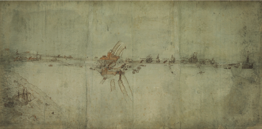
All the same, the contrast between the idealized situation visible in the map and the miserable state of Bruges’ actual hydrography during this period is striking. A notable feature of this map is that the waterways between Bruges and the North Sea were depicted as being much shorter and straighter than they actually were. Moreover, all bends and irregularities in the canals were omitted, suggesting that it was a short and easy trip to the city centre. Large, three-master ships, which in reality could never have entered the city, are seen sailing right up to the Koningsbrug bridge at its very heart. These improbable vessels fly the flags of the Hanseatic League and Castile, home to two of the most important foreign merchant groups whose presence Bruges wanted to secure.Footnote 61 Again, the ideological concern to represent an ideal commercial city and its access to the sea seems to have been at play throughout the scene.
City maps (map type 3)
In the second half of the sixteenth century, reflecting the renewed Renaissance interest in the city,Footnote 62 a new type of map appeared. Three-dimensional bird's-eye perspectives focused on the urban territory intra muros as a whole, with less attention for the surrounding countryside. They were published on loose sheets or in atlases such as those edited by Lodovico Guicciardini, Georg Braun and Frans Hogenberg, Frederik de Wit and Johannes Blaeu.Footnote 63 Still, in the maps of this type created in Bruges, the hydrographical situation and the port facilities remained an important theme. Even Jacob van Deventer, a cartographer who spent just a brief time in Bruges and had no relationship to the urban authorities, was aware of their significance. In the middle of the sixteenth century, van Deventer produced a highly accurate topographic map of the city on a single sheet of paper, but added an extra leaf in order to depict the Reie between Bruges and Damme, and a second canal to Koolkerke.Footnote 64
By far the most celebrated depiction of pre-modern Bruges was produced by the Bruges painter and engraver Marcus Gerards, and dates from 1562. Brugae Flandrorum Urbs et Mercatu Celebre shows the city, the surrounding countryside and part of the North Sea from a bird's-eye perspective (see Figure 8).Footnote 65 Whereas our knowledge about the context in which earlier maps were created is fragmentary at best, we are relatively well informed about the motivations behind this document. Explicitly referring to the ideologically preconceived idea of how their urban space should be represented, the city's magistracy wanted to order a map in which the cartographer made ‘the water between Bruges and Sluys wider, so one would notice the good navigability’.Footnote 66 Although the Antwerp printer Willem Silvius was initially asked to produce it, Marcus Gerards succeeded in obtaining the commission after mediation by the international artist and humanist network to which he belonged, and which was centred around Abraham Ortelius.Footnote 67 The authorities’ desire to showcase their city as a hotspot for international trade governed nearly every decision Gerards took in the creation of his bird's-eye view. A similar initiative was undertaken in Venice, where the threat to the city's commercial hegemony mobilized the rulers to order a series of images that propagated its greatness.Footnote 68
Marcus Gerards, Brugae Flandrorum Urbs et Mercatu Celebre, 1562, Bruges, Public Library, Historisch Fonds, HF530.

Bruges’ commercial infrastructure, essential in its portrayal as an attractive hub for merchants from all over Europe, is visible in Marcus Gerards’ map, even if it is occasionally somewhat lost in the mass of topographical details depicted in this ambitious work. Yet, perhaps surprising for a commerce dominated map, is the absence of the hustle and bustle of international trade. The inner city is shown in great detail, but is completely devoid of people, animals, conveyances or street furniture. However, this ‘silent city’ concept may derive from a stylistic choice; indeed, Gerards was following a pictorial convention that had been circulating for some time in Europe.Footnote 69 Rosselli's famous Pianta della Catena of Florence (c. 1470–80), the anonymous view of London (c. 1550), Bononiensis’ map of Antwerp (1565) and many bird's-eye views published in Braun and Hogenberg's Civitates Orbis Terrarum (first volume, 1572) all shared the same preference for empty streets and squares. Yet, references to trade are made in Gerards’ map, where large and small ships ply the waters between the Zwin mouth, the outports of Sluys and Damme and Bruges.Footnote 70
Many other cartographic and iconographic elements in the conceived space of Gerards’ map were the direct results of the city government's expectations. It had to be clear that the city had made every effort to improve its port infrastructure. The painter represented the Verse Vaart between Sluys and Damme, which had been dug between 1548 and 1557, and its lock system, which was still under construction when the bird's-eye view was printed. Moreover, Gerards made the hydrographic situation look better than it actually was. Whereas most of the North Sea is shown as very turbulent and even terrorized by gigantic sea monsters,Footnote 71 the Zwin mouth is markedly quieter – a safe haven where ships with furled sails gather in order to reach the city's harbour (see Figure 9). Between the city and the sea, Gerards drew a dotted line to indicate where he had changed the scale. Everything on the left is represented much smaller than on the right, and as a result, Bruges’ connection to the sea appears much shorter and straighter than it actually was.Footnote 72
Detail from Marcus Gerards, Brugae Flandrorum Urbs et Mercatu Celebre, with the connection between Bruges on the right and the North Sea on the left, 1562, Bruges, Public Library, Historisch Fonds, HF530.
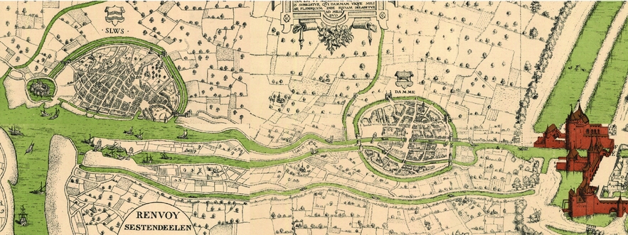
Most of the countryside surrounding the city is shown rather generically, with only a monastery and a few smaller, isolated village churches, but an exception is made for Bruges’ outports, Damme and Sluys, which played a crucial role in its accessibility and which were depicted in remarkable detail.Footnote 73 In accordance with the city's instructions, the canals within the city walls were drawn significantly wider than they were in reality, and most of them were provided with perfectly maintained stone quaysides. Nearly entirely unpeopled, boats are seen floating on the water, some of which would never have been able to pass under the canals’ many bridges. And while Gerards depicted the water current in the south of the city, the canals used for international trade were all still and perfectly controlled. What mattered was not to show the city's commercial activity, but that its waterways were navigable.
A final important artistic intervention concerns the use of a virtual viewpoint in the sky. The adoption of a three-dimensional perspective has the advantage that it allowed for the detailed coverage of many topographical elements. According to Brown, this ‘eye-witness style’ permits viewers easily to identify the sites depicted, but the manipulation of the space also misleads them in order to reinforce the ideological content.Footnote 74 In her study of Jacopo de’ Barbari's bird's-eye perspective of Venice, Howard argued that the artist not only intended to achieve remarkable accuracy, but also deliberately manipulated the image to convey a particular iconographic idea: to give Venice the visual appearance of a dolphin.Footnote 75 In Marcus Gerards’ map, the detailed depiction of Bruges’ hydrography and port infrastructure mattered less than the ideologically inspired image of a quiet, well-protected and well-equipped city, close to the sea, where merchants could trade in ideal circumstances.Footnote 76
It is likely that Gerards’ commission constituted the city government's ultimate attempt to conceive Bruges cartographically as an international trade centre. Since the 1470s, the city's economic position had only deteriorated and by the end of the 1560s, it must have dawned on everyone that its golden age was not going to return. In 1553, the last official representation of the foreign merchant communities, that of the Hanseatic League, left Bruges.Footnote 77 Then, during the 1560s, the bankruptcies of the Spanish state, economic decline and the first outbreaks of religiously inspired violence also started to affect Antwerp. In 1585, following 20 years of devastating warfare, the centre of international trade moved even further north, to Amsterdam.Footnote 78 However inventive the cartographic conception of commercial space might have been, its impact was negligible in the face of the changes in international trade flows and the consequences of military conflict. The city paid two more cartographers to map Bruges’ hydrography in 1564–66, and apart from two isolated commissions in the 1580s, they were the last documented instances in which the city invested in the cartographic representation of its waterways in the sixteenth century.Footnote 79
Bruges and its graphic identity
A perspicuous commentator on Bruges’ unstoppable decline was the elderly Zeger Van Male. As a merchant and alderman, he had been personally involved in the city's attempts to stop the crisis. In the 1590s, drawing on his youthful experiences and stories he had either read or heard, van Male wrote a jeremiad in which he looked back at the time ‘when trade came from all other countries and kingdoms, and when all nations of the world were present in the city of Bruges’.Footnote 80 He ruminated on the state of the waterway to Sluys that had been completed at great expense in 1566, soon after Marcus Gerards had finished his map. It had suffered heavily from the war in subsequent decades, become silted up and the infrastructure ruined, with lots of its materials sold and the locks in need of repair. In the 1590s, a fortress and a dyke were constructed in front of the canals’ mouths and Bruges lost its direct connection to the sea. ‘We have no more rivers, only a pool’, Van Male lamented. ‘What benefits do your two locks in Sluys, your new canal and your pound lock, which have cost more than sixty thousand pounds, bring you now?’ ‘Where is the money now, to repair and restore the canal and the locks, so they could be navigable again for the merchant?’Footnote 81
In his complaint, Van Male voiced the same concerns that had informed the iconographic programme of the town plans and maps depicting Bruges and its wider hydrographical context between the 1470s and the 1560s. In spite of the differences in scale, style and function between the various cartographic sources under scrutiny here, and independent of the technical and stylistic evolutions town and city mapping underwent throughout the sixteenth century,Footnote 82 one motif recurs constantly: the city's accessibility. This theme is always either implicitly or explicitly present in the message these pictures seem to convey, regardless of whether they genuinely reflect the physical landscape, idealize the current situation or document a solution for the city's problems. In the case of Gerards’ map, we know that the cartographer was explicitly commissioned to project the ‘good navigability’ of the town, but this was apparently an underlying concern for the makers of all maps and city plans preserved for this period. They communicated that Bruges was still a place that could easily be reached and where merchants could trade in the best possible circumstances, against low transaction costs.
For Bruges, maritime accessibility was the crux of what Fournier-Antonini has called a city's ‘graphic identity’, an image emblematic of a particular place, which was not so much the result of stylistic or technical choices or the site's topography, but of its local political, economic and social context.Footnote 83 During the late fifteenth and sixteenth centuries, Bruges’ position as an easily accessible centre of international trade was under threat. Insecurity over its economic viability gave rise to a specific discourse shared by most of the city's inhabitants: it was the city government's duty to provide foreign merchants with excellent infrastructure for transportation and trade in order to reduce transaction costs. This ideology can be detected in many textual sources of the period, but it also determined the city's cartographic production. Despite, or rather because of, its greatly reduced position as an international commercial hub, engineers and artists continued to conceive of Bruges as the logical endpoint of networks of canals and other waterways.
Bruges’ graphic identity had a lot in common with the way in which late medieval and early modern Venice was visually represented, though it lacked the emphasis on the waterways’ defensive purposes that was typical of many Venetian maps.Footnote 84 Mapmakers in other cities highlighted other specific characteristics, informed by the inhabitants’ particular discourses and the contexts in which they were embedded. The spatial conceptions that underpinned city maps and plans can provide us with unique windows into these ideologies. Much more than mere functions of artistic or technical developments or objective reflections of changes in the urban fabric, they should be studied as privileged sources for the ways in which late medieval and early modern city dwellers thought about the place that they considered home and its relationship with the wider world.Footnote 85



