
The site of Falerii Novi in the middle Tiber Valley represents one of the finest available opportunities for an archaeological study of urbanism in ancient Italy. This opportunity presents itself both because the settlement's nearly complete abandonment in the post-Roman period has left a largely greenfield site within well-preserved ancient walls and because several decades of non-invasive research already provide a good understanding of the ancient city's morphology. This paper details a newly formed initiative to pursue the site's urban development through a combination of methodologies. The ‘Falerii Novi Project’ (FNP) forms a research collaboration between the British School at Rome (BSR) and the Universities of Harvard (USA) and Toronto (Canada), with input from Cambridge University (UK), Ghent University (Belgium) and the Università degli Studi di Firenze (Italy). The multinational project is undertaken by concession of the Soprintendenza Archeologia, Belle Arti e Paesaggio per la provincia di Viterbo e per l'Etruria meridionale and the kind permission of the landowner. This cumulative effort represents the start of a planned multi-year initiative to explore the city's archaeology from multiple perspectives and using a variety of methodologies. At the core of the FNP lies a campaign of stratigraphic excavations — the first scientific excavations of this scale within the urban area. However, the project also presents a wider platform for collaboration and the application of a variety of methods, partners and institutions in pursuit of a broader intellectual aim: to confront in a holistic manner the history of a Roman city through time, from Falerii Novi's origins through its post-Roman transformations, with particular attention to urban lifeways and socio-historical processes. As work begins, the collaborators find it opportune to present the project's scope and aims in the following contribution. We review Falerii Novi's history and its history of scholarship before describing the potential that our project holds to advance knowledge both of the site and of the broader understanding of urbanism during the Roman and adjacent periods.
1. HISTORICAL BACKGROUND
The site of Falerii Novi is now located just 5.5 km southeast of modern Fabrica di Roma (Viterbo, Lazio). The ancient city was a medium-sized urban site (31.86 ha) within a network of settlement in the middle Tiber Valley (Fig. 1). The site sat astride the Via Amerina, about 50 km north of Rome on a low-lying tuffaceous plateau defined on its southern side by a deep natural ravine (Keay et al., Reference Keay, Millett, Poppy, Robinson, Taylor and Terrenato2000: 4–5). The area formed part of the ager Faliscus and saw settlement from a much earlier period, while ancient sources relate that Falerii Novi itself was founded ex novo sometime shortly after Roman conquest of the Faliscan centre at Falerii Veteres, modern Civita Castellana, in 241 BC.Footnote 1 The clearest source in this regard is the abridgement of Cassius Dio by the Byzantine (twelfth-century AD) writer Zonaras, who goes so far as to attach the story of Roman relocation to the city's physical topography, claiming Romans relocated the population of the Faliscan centre to the less defensible, low-lying site (8.18). This straightforward sequence of events assigns the early city clear ideological and political purposes,Footnote 2 which have often made Falerii Novi's foundation into a type case for harder-edged interpretations of Roman imperialism's impact upon urban development in Italy (cf. Terrenato, Reference Terrenato2019: 133). Although there is no certain evidence of the city's colonial status, the urban foundation is often interpreted in the framework of Roman Republican colonization in Italy (cf. Di Stefano Manzella, Reference Di Stefano Manzella1990). The evidence on the ground, however, suggests greater complexity. For example, as Terrenato (Reference Terrenato, Keay, Millett, Poppy, Robinson, Taylor, Terrenato and Patterson2004: 234–5) points out, it is not clear why, following Zonaras's account, a foundation purportedly intended to punish the rebellious Faliscans would have been endowed with substantial defensive walls. Against this background, Millett (Reference Millett, Keller and Roth2007) detects a rectangular settlement pattern focused upon the area of Falerii Novi's forum; this may represent the settlement's original plan as a rectangular castrum-style site similar to other Middle Republican military settlements, while the more irregular, D-shaped circuit of walls may belong to a later phase of expansion when aspects of the city were remade to echo the older centre (see also Keay et al., Reference Keay, Millett, Poppy, Robinson, Taylor and Terrenato2000: 85–6; cf. Wallace-Hadrill, Reference Wallace-Hadrill, Allen, Eckardt and Rippon2013).
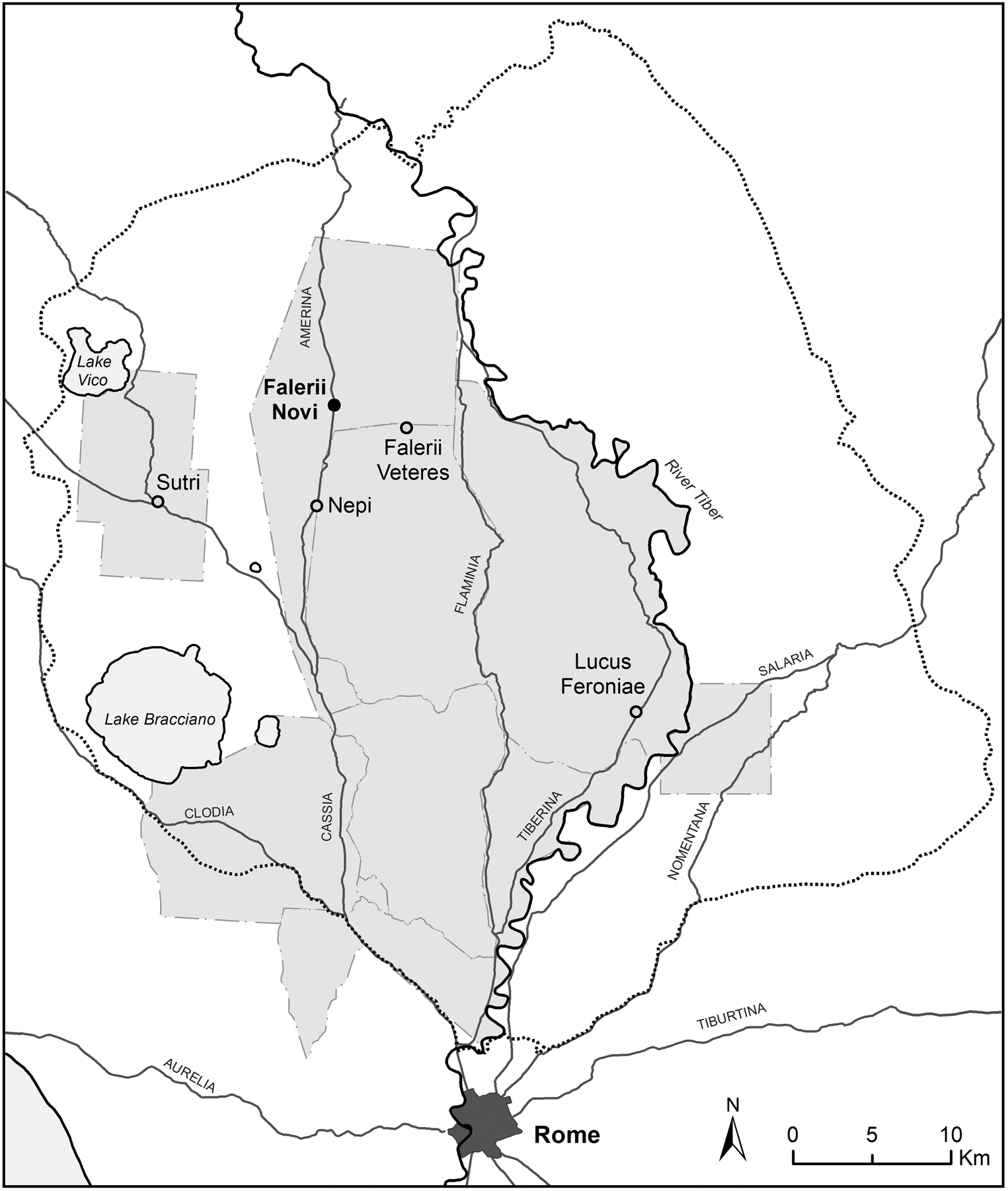
The location of Falerii Novi in relation to Rome, major ancient roads, preceding BSR surveys (areas in grey) and sites mentioned in the text.
Central to this discussion is the question of the relationship of old to new Falerii (Biella, Reference Biella and Biella2020). Whilst we know nothing archaeologically of the conflict and destruction event, a general scarcity of archaeological material dated post-241 BC at Falerii Veteres suggests a decrease in urban activity and is supplemented by indications that at least two of the old settlement's sanctuaries (Vignale and Scasato) were systematically dismantled, with architectural elements and votives dumped into adjacent cisterns from the late second century BC (Benedettini, Carlucci and De Lucia Brolli, Reference Benedettini, Carlucci, De Lucia Brolli, Comella and Mele2005: 225; Biella et al., Reference Biella, Carlucci, De Lucia Brolli, Giuliani, Lambiase, Ligabue, Materazzi and Pacifici2022: 97). The construction of the Via Flaminia (221 BC) through the Tiber Valley bypassed the old Faliscan settlement, seemingly confirming its marginality already by that date. However, greater attention has been given in recent years to evidence for continued cult activity at several locations in the old city (e.g. the sanctuaries of Sassi Caduti and Celle) and its countryside, albeit with a transformation in practice seen through new types of ex-votos and offerings perhaps geared to specific social strata, as well as some signs of later Augustan-era habitation and Imperial coins found at the Celle sanctuary (De Lucia Brolli, Reference De Lucia Brolli1991; Benedettini, Carlucci and De Lucia Brolli, Reference Benedettini, Carlucci, De Lucia Brolli, Comella and Mele2005: 225–8; Biella and Nonnis, Reference Biella, Nonnis, Caínzos and Acuña2021; cf. Ov., Am. 3.13). This evidence would suggest the older site continued to some extent alongside Falerii Novi, either as a smaller settlement of its own, with sanctuaries serving a largely rural population, or as a cult centre connected to the new city.Footnote 3 Perhaps there is a reflection of coexistence in Strabo's (5.2.9) listing in this area of both a site called Falerii and a neighbouring one called ‘Faliscum’ (cf. Di Stefano Manzella, Reference Di Stefano Manzella1976–7: 155–6).
There are also some indications of sociocultural continuity with indigenous occupation at Falerii Novi itself, although there remain many open questions. Pre-Roman presence in the city's immediate area has been evident from the initial phases of the South Etruria Survey (e.g. Frederiksen and Ward-Perkins, Reference Frederiksen and Ward-Perkins1957: 158–9), while Faliscan ceramics are noted from contexts and tombs just outside the urban area (De Lucia Brolli, Reference De Lucia Brolli1995–6). Faliscan tombs along the course of the Via Amerina also suggest that some form of this route predates the Roman town. This material is joined by a handful of bucchero sherds and a fragment of a third-century BC red-figure olpe recovered by augering during the FNP's June 2021 campaign in an area that was previously interpreted as a Capitolium using the magnetometry and GPR data (Keay et al., Reference Keay, Millett, Poppy, Robinson, Taylor and Terrenato2000: 11–14; Verdonck et al., Reference Verdonck, Launaro, Vermeulen and Millett2020: 711; Bernard et al., Reference Bernard, Andrews, Ceccarelli, Dodd, Kay, Leone and Vermeulen2022: 344). Radiocarbon dating of charcoal fragments recovered from anthropic layers by corings in this same campaign reported dates of 277 ± 24 BCE and 232 ± 24 BCE. Without fuller stratigraphic information, we can say little about what sort of activity this material represents, except to note it in support of further exploration. The data need not represent the residue of anything more substantial than a rural site in the ager Faliscus or simply traffic crossing through the area along the older route that preceded the Roman Via Amerina. There are also possible signs of Faliscan culture at Falerii Novi from the Republican and Imperial periods, including attestations of cults known from the older site and neo-Faliscan inscriptions found at the city (Bakkum, Reference Bakkum2009: 493–518). Other aspects of the site's topography, such as the steep undercutting of bedrock beneath stretches of the city-walls or the location of sanctuaries along the periphery of the intramural area, may reflect deliberate attempts to recreate spatial or topographical elements of the older Faliscan site (Millett, Reference Millett, Keller and Roth2007).
The legal status of Falerii Novi during the first two centuries following its foundation is debated; by the later Republic, inscriptions confirm the city's status as a municipium (Di Stefano Manzella, Reference Di Stefano Manzella1981: 105–6; Reference Di Stefano Manzella1990; cf. Sisani, Reference Sisani2018: 63–4). In the early Empire, Falerii Novi probably underwent the same process of monumentalization observed at other nearby urban sites. Some building activity may have been directed by local elites known to be part of the ‘Augustan aristocracy’ (Papi, Reference Papi2000: 38–52; Patterson, Witcher and Di Giuseppe, Reference Patterson, Witcher and Di Giuseppe2020: 144–6), while Augustan patronage of the city is also attested (CIL XI 3083; Di Stefano Manzella, Reference Di Stefano Manzella1990). Inscriptions mention Imperial-period repairs to the amphitheatre (CIL XI 3112), road-building work on streets called the Via Augusta and the Via Sacra (CIL XI 3126), and refer to various urban temples, porticoes and a chalcidicum (CIL XI 3123–4). The precise spatial extent and chronological timing of these and other interventions remain to be established. The results of the geophysical surveys suggest several phases within the urban grid; it may be that the somewhat smaller insulae extending from the forum to the walls to the south represent a reorganization of urban space at some point during the Imperial period (Keay et al., Reference Keay, Millett, Poppy, Robinson, Taylor and Terrenato2000: 85; Millett, Reference Millett, Keller and Roth2007: fig. 2).
The city has been suggested as the birthplace of Gallienus, who was proclaimed redintegrator coloniae Faliscorum by the city's ordo et populus (CIL XI 3089–94; Alföldi, Reference Alföldi1929: 269; cf. Di Stefano Manzella, Reference Di Stefano Manzella1990). Dedications from the site naming the late-third-century AD emperor suggest his role in the restoration of public buildings (CIL XI 3089; see Patterson, Witcher and Di Giuseppe, Reference Patterson, Witcher and Di Giuseppe2020: 236). Previous epigraphical research has also suggested evidence of a late-third-century AD crisis (Di Stefano Manzella, Reference Di Stefano Manzella1981), in line with trends traditionally thought to be observable more broadly in the Empire (Witschel, Reference Witschel2004). Test-pitting during the first season of the FNP discovered a coin issued c. AD 317/18 by Constantine I from the mint of Rome in the area of the macellum west of the forum (RIC VII 111; Bernard et al., Reference Bernard, Andrews, Ceccarelli, Dodd, Kay, Leone and Vermeulen2022: 343),Footnote 4 and nineteenth-century excavations recovered from the site a hoard of over 1,700 coins of Ricimer (AD 457–72) (Asolati, Reference Asolati2005). In the view of Keay et al. (Reference Keay, Millett, Poppy, Robinson, Taylor and Terrenato2000: 73), ceramic scatter on the surface suggested activity in the area immediately around the forum from the third to sixth century, and the elaborate, curvilinear architecture of a bath complex and domestic structures detected by ground-penetrating radar (GPR) in the southwest area of the city may reflect late antique remodelling or construction (Verdonck et al., Reference Verdonck, Launaro, Vermeulen and Millett2020: 714). Finally, Duchesne (Reference Duchesne1892: 491–2) located the bishopric of Aquaviva, first mentioned in AD 465, at Falerii Novi, around which time the city's population was possibly served by a large catacomb, known as Santi Gratiliano and Felicissima, with just under 1,000 tombs, c. 400 m south of the city's west gate (the so-called Porta Giove) along the road leading to Sutri (Fiocchi Nicolai, Reference Fiocchi Nicolai1988; Moscioni, Reference Moscioni, Gajano, Caciorgna, Fiocchi Nicolai and Scorza Barcellona2010; Patterson, Reference Patterson, Patterson, Witcher and Di Giuseppe2020).
Ceramic and numismatic materials from the 2022 campaign of the FNP confirm a significant fifth- and sixth-century presence across those areas explored on the site (Andrews et al., Reference Andrews, Bernard, Ceccarelli, Dodd, Fochetti, Kay and Vermeulen2023).Footnote 5 Based on the lack of any later finds in the earlier pedestrian survey of Keay et al. (Reference Keay, Millett, Poppy, Robinson, Taylor and Terrenato2000: 73), it had been suggested that Falerii Novi was abandoned shortly after the Lombard invasions of the late sixth century (Patterson, Witcher and Di Giuseppe, Reference Patterson, Witcher and Di Giuseppe2020: 236) when much of the population perhaps moved back to the more defensible site of Civita Castellana, where early structures of Christian cult reusing Roman material might date to the seventh to ninth centuries AD (Fiocchi Nicolai, Reference Fiocchi Nicolai1988: 263–4; Cavallero, Reference Cavallero and De Lucia Brolli1991). However, pottery recovered during the first campaigns of the FNP already encourage reconsideration of the timing of the city's decline. During the 2022 season, vetrina pesante (e.g. forum ware) and vetrina sparsa, which together date to a range between the ninth and eleventh centuries AD, were found across all three trenches (though most frequently in the macellum, on which see below). Both maiolica arcaica and maiolica moderna attest to occupation through the medieval and early modern periods. The vetrina sparsa and maiolica probably correspond to a long period of activity that began in the eleventh or twelfth century with the foundation of the monastic community around the church of Santa Maria di Falleri by Cistercians from Saint-Sulpice-en-Bugey (Illiano, Reference Illiano1989). The vetrina pesante, however, is more important, as it attests to a relatively sizeable area of occupation and activity within the city-walls still during the early medieval period. This potentially alters what has heretofore been reconstructed as a gap in the site's occupation between the supposed late antique transition back to Falerii Veteres (Civita Castellana) and the foundation of Santa Maria di Falleri. The continuing role of the Via Amerina must also be considered within this time-frame, as it is believed to have acted as a strategic communications route between Rome and Ravenna from the end of the sixth century AD as part of the corridoio bizantino (Patterson, Witcher and Di Giuseppe, Reference Patterson, Witcher and Di Giuseppe2020: 253; cf. Cifani and Munzi, Reference Cifani, Munzi and Christie1995: 390–2; Marcelli, Reference Marcelli, De Lucia Brolli, Biella and Suaria2012: 133).
The state of the site today, with almost no ancient monuments above ground within the walls, suggests a phase of significant robbing or removal of ancient materials, but the timing and pace of such large-scale spoliation, as well as its specific purpose, remain unclear (Christie, Reference Christie2006: 196). As discussed in the next section, excavations have been undertaken by several owners of the land and other parties starting in the early nineteenth century, and relatively regularly since (cf. Di Stefano Manzella, Reference Di Stefano Manzella1979, Reference Di Stefano Manzella1981).
2. PREVIOUS STUDY OF THE SITE
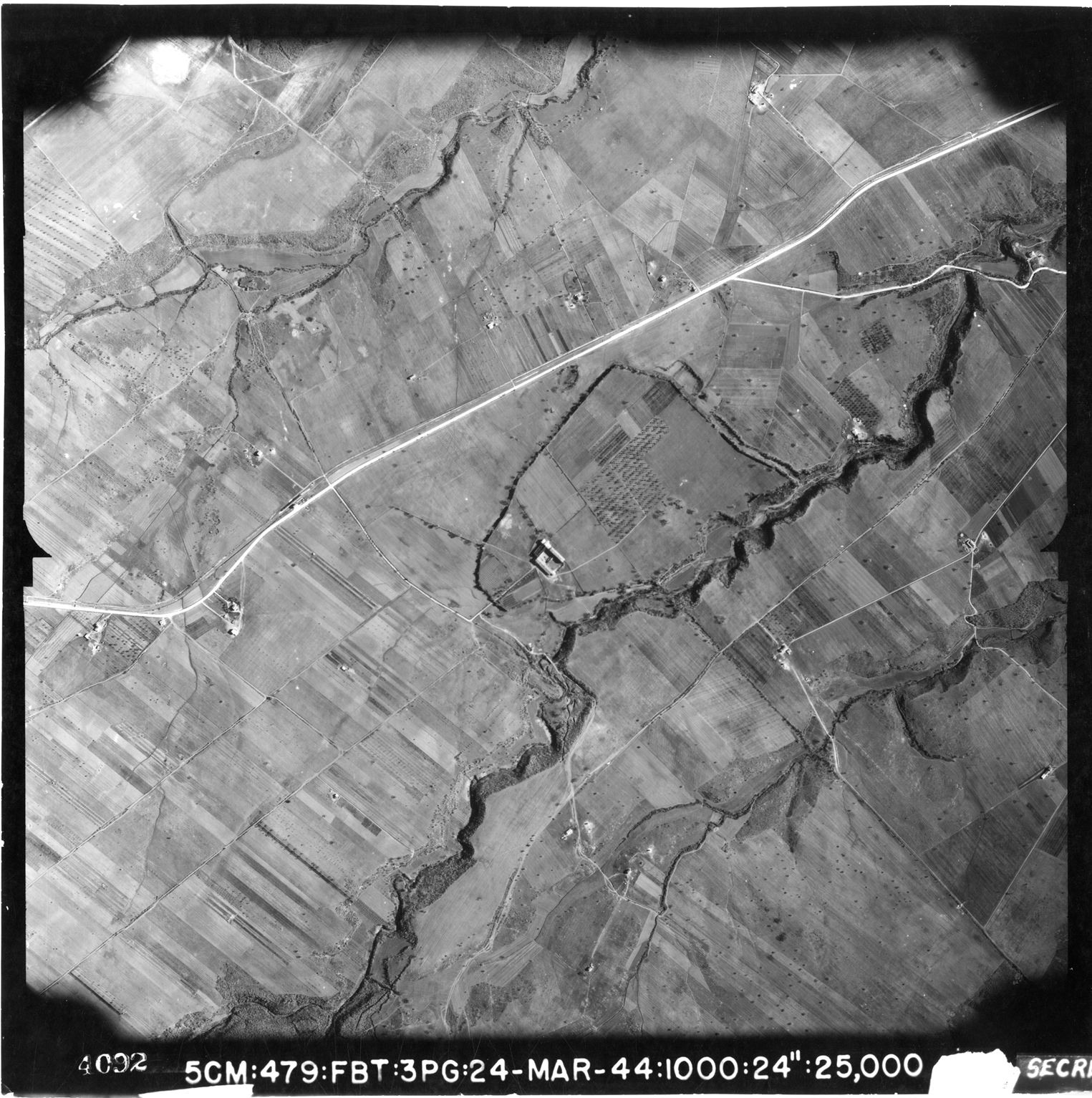
This overview plainly shows the considerable historical detail already achieved for this now largely buried urban site, while it also points at some initial research questions. The FNP intends above all to investigate the city's early and late phases, the pace and spatial configuration of its urban development over time, and the changing society that inhabited the site. Interest in these and other questions has prompted a series of modern studies of the site to date. The recent preliminary publication (Verdonck et al., Reference Verdonck, Launaro, Vermeulen and Millett2020) and mapping of the high-resolution GPR survey undertaken by the Universities of Ghent and Cambridge significantly enhanced the detailed plan recorded by the earlier magnetometry survey (Keay et al., Reference Keay, Millett, Poppy, Robinson, Taylor and Terrenato2000; Hay et al., Reference Hay, Johnson, Keay and Millett2010).Footnote 6 These non-invasive surveys, together with remote-sensing studies of the site,Footnote 7 represent the latest phase of modern study of the site, but we may return for an account of its archaeology to the fundamental work of Di Stefano Manzella (Reference Di Stefano Manzella1979) to document early excavations on the site, conducted between 1821 and 1830, and to draw together other piecemeal work at the site up to the 1960s. Early nineteenth-century excavations were followed by several topographical studies of Falerii Novi with descriptions and illustrations of its ruins (Gell, Reference Gell1834; Canina, Reference Canina1846–51; Dennis, Reference Dennis1848). The first modern systematic study of the city's territory, including the ager Faliscus and Falerii Novi itself, came shortly afterwards, from 1881 to 1897, as part of the creation of the Carta Archeologica d'Italia (Gamurrini et al., Reference Gamurrini, Cozza, Pasqui and Mengarelli1972; Cozza and Pasqui, Reference Cozza and Pasqui1981). Continued interest in the site and its region supported authorized private excavations, which in 1898 were led by Mancinelli Scotti (cf. Pasqui, Reference Pasqui1903; Ligabue, Reference Ligabue, Biella and Tabolli2021), as well as contemporaneous private excavations of the nearby sanctuaries and necropoleis of Civita Castellana. Material from the latter was acquired by Bernabei to form the core of the first collection at the Villa Giulia Museum in Rome (Ligabue, Reference Ligabue2022). Shortly after World War II, Frederiksen and Ward-Perkins (Reference Frederiksen and Ward-Perkins1957) expanded upon these earlier topographical studies as part of the broader South Etruria Survey (Fig. 1), and combined Royal Air Force aerial photographs (Fig. 2) with surface survey documentation to provide a first understanding of the city's extra-urban road network.
Aerial photograph taken over Falerii Novi by the Royal Air Force on 24 March 1944. The outline of the city-walls is clearly visible along with the Rio Purgatorio valley (Reproduced from the Aerofototeca Nazionale Archive, Rome: RAF_1944_143_55_4092_56813_0).
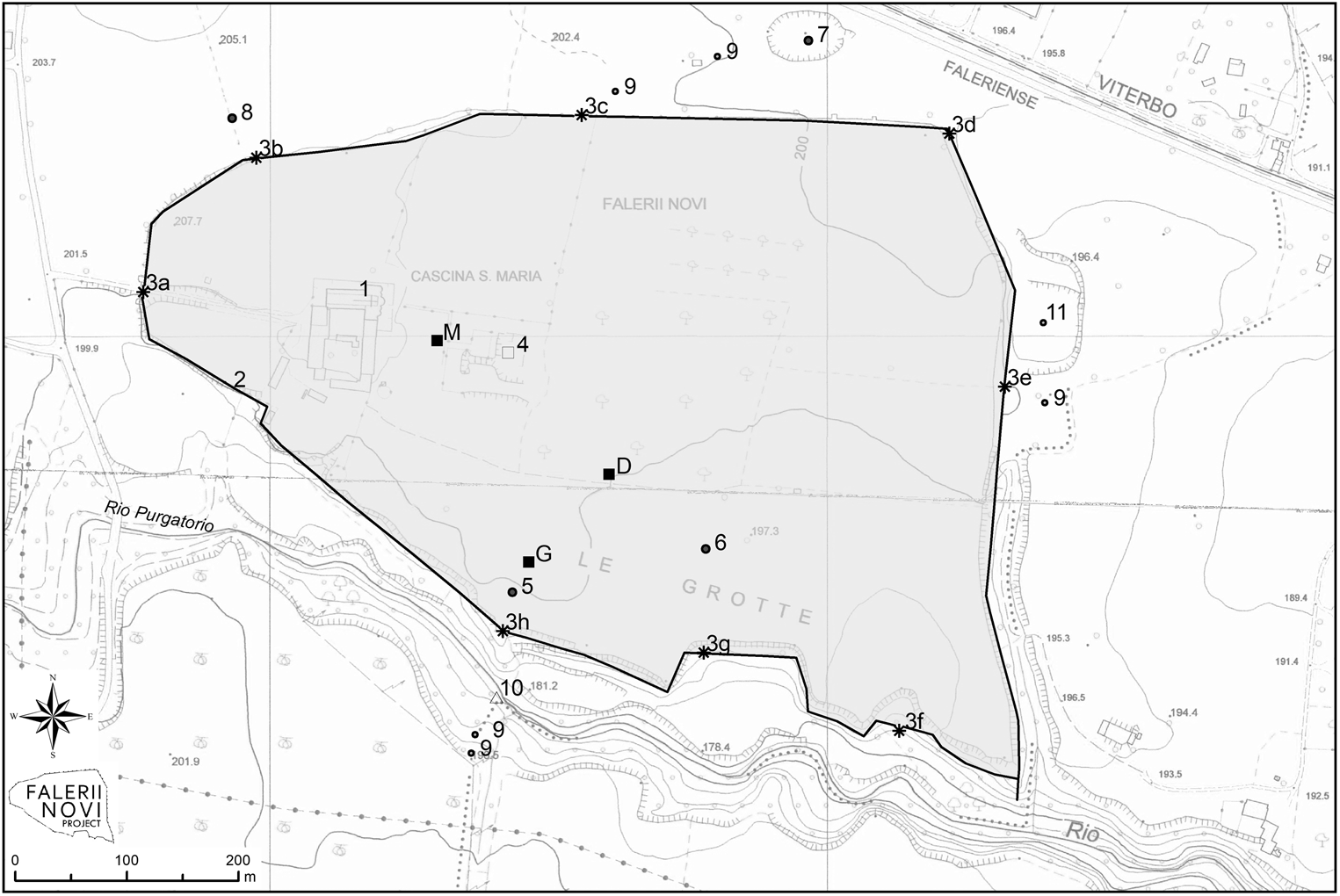
From 1969 to 1975, the eastern half of insula XXXI (as defined in Keay et al., Reference Keay, Millett, Poppy, Robinson, Taylor and Terrenato2000, and by FNP as ‘Area 4’) to the east of the church of Santa Maria di Falleri was excavated by the Soprintendenza. The area opened by these excavations remains visible today (Fig. 3.1). Investigations exposed an intersection of the main east–west and north–south street axis (the so-called decumanus maximus and the Via Amerina), as well as a large complex built in opus quadratum immediately west of the forum's southwestern flank, as identified by geophysical survey (cf. Keay et al., Reference Keay, Millett, Poppy, Robinson, Taylor and Terrenato2000; Verdonck et al., Reference Verdonck, Launaro, Vermeulen and Millett2020). Only minor details of these excavations are published (Brunetti Nardi, Reference Brunetti Nardi1972, Reference Brunetti Nardi1981; De Lucia Brolli, Reference De Lucia Brolli1995–6). Further work in this area was conducted by the Soprintendenza in 1989, at the northern and southern end of the excavated north–south road (De Lucia Brolli, Reference De Lucia Brolli1995–6; Peña, Reference Peña1997). A sondage just to the east of the intersection between the two main roads aimed to verify the continuation of the east–west axis and its relationship to the forum, revealing a floor made of reused stone blocks and slabs from column shafts and suggesting later phases of (re)use in this central area. Materials from these excavations were studied in 1997 by a team from the American Academy in Rome, with a special focus on the ceramics and on identifying possible clay sources for local production (Peña, Reference Peña1997).Footnote 8
Falerii Novi with its known monuments indicated: 1. Church of Santa Maria di Falleri; 2. city-wall; 3a. west gate (Porta di Giove); 3b. northwest gate; 3c. north gate; 3d. northeast gates; 3e. east gate; 3f. Porta Puteana; 3g. southeast gate; 3h. south gate; 4. 1969–75 excavations (Area 4); 5. via Amerina; 6. theatre; 7. amphitheatre; 8. aqueduct; 9. mausoleum; 10. bridge; M: macellum excavation 2022 (Area 1); D: domus excavation 2022 (Area 2); G: south gate excavation 2022 (Area 3).
This largely unpublished excavation is now part of a systematic topographical restudy undertaken as part of the FNP using an interdisciplinary approach that combines traditional methodologies, including survey and archival research, with modern non-invasive techniques. Structural analysis over the insula's area (c. 62 × 42 m; 209 × 141 pedes excluding streets) has recorded more than 100 stratigraphic units related to different phases in the use of the complex, along with heavy spoliation. A lack of accessible stratigraphic data from the earlier excavations led to the use of a series of cores by a team from the University of Ghent in June 2022 to test stratigraphy under excavated levels. Plans and elevation drawings of this insula are being made using georeferenced photogrammetry together with a new GPR survey across an area of 426 m2 over the western, unexcavated portion of insula XXXI. As this entire insula was unable to be surveyed and integrated within the recent geophysical studies, this work also serves to fill a gap in our understanding of the complete city plan.
Several smaller excavations, mostly concentrated in the western part of the city, were also carried out around 1990 by the former Soprintendenza Archeologica per l'Etruria meridionale (De Lucia Brolli, Reference De Lucia Brolli1995–6), including investigations during the restoration of the church, both within the nave and the area immediately surrounding it along the northern transept and apse. These revealed a stretch of the main east–west road aligned with that visible in the excavated area of insula XXXI and used as a foundation for the southern transept, an intersection with a secondary north–south road, and parts of a domus and opus quadratum building, identified by the excavators as a possible temple. Along the exterior part of the apse, a cemetery was brought to light and 184 tombs were excavated. Additional excavations were conducted at different times between 1990 and 1995 along the northern intramural stretch of the so-called Via Amerina, as well as near the north gate (Fig. 3.3c) and in a central area at the intersection with the main east–west road next to insula XXXI (above). In the former area, a beaten earth layer above the Roman Via Amerina was found and dated to the tenth century AD based on ceramic material. West of this northern stretch of the Via Amerina, rooms from two private houses dated between the first century BC and first century AD were excavated, as well as small investigations next to the north gate in areas already explored during the nineteenth century with the aim of defining the exit of this major road from the city and illuminating possible blocking of the gate and the posterula. Around this time the Soprintendenza also excavated a tomb from the nearby Necropoli dei Tre Camini, dated in its first phase to the last decades of the third century BC. Further excavations in the burial area along the Via Amerina to the city's south at the site of Cavo degli Zucchi were conducted by the Gruppo Archeologico Romano.Footnote 9
3. RESEARCH AIMS
The research aims of the FNP build upon this history of exploration, while reflecting the backgrounds and interests of the project's membership. Collectively, the project's goals speak to a desire to understand Falerii's urban development and transformation over the long period of its occupation from a sociohistorical perspective by employing the full toolkit of current archaeology and archaeological science. Consequently, while one main focus is on the built environment of the city itself, the FNP is not limited to this perspective, as it aims to explore the site's formation and the lifeways of its inhabitants in a more holistic manner. This aim stems from a desire to engage with recent trends in the study of Roman urbanism, but also to integrate research methods to date only employed to a limited extent in urban contexts, and most often at sites with exceptional site formation processes, such as Rome itself or the cities of the Vesuvian region. Many of these approaches develop our use of rural or landscape analytical techniques in urban contexts and leverage the fact that we possess site-scale survey information for the whole intramural area (Johnson and Millett, Reference Johnson and Millett2012). The situation of high-quality geophysical survey data on a large scale and an available urban site is difficult to parallel in Italy, and it presents an excellent opportunity to integrate the different resolutions of both survey and excavation in a way that offers a more complete history of this city through time.
Urbanism has long been a cornerstone of Roman archaeology and history, with a ‘world of cities’ around the Mediterranean understood as a signal feature of the Empire and its political economy, culture and society.Footnote 10 At the same time, the field of ancient studies increasingly moves away from narratives that privilege empire in chronological and sociocultural terms, and this in turn has led to closer scrutiny of the idea of the Roman city as a discretely analysable product of Roman Imperial power. Provocatively, Horden and Purcell (Reference Horden and Purcell2000: 92) argued for ‘ruralizing’ ancient history, that is, for dissolving the ancient city as a secondary feature of broader networks of connectivity across landscape. Their challenge has not been universally accepted, as it remains hard to imagine Roman studies without cities (Harris, Reference Harris and Harris2005: 29–34). However, their work encourages welcome tendencies in recent research to analyse cities not in isolation, but rather as nodes within broader landscapes and patterns of human mobility (Erdkamp Reference Erdkamp1999; van Oyen, Reference van Oyen2015; Vermeulen and Zuiderhoek, Reference Vermeulen and Zuiderhoek2021). Thus, one recent publication on ancient cities explicitly avoids celebrating ancient urban life and instead insists on its precarity and temporal compression (Woolf, Reference Woolf2020). Urban life remains essential to Roman studies, but the city can no longer stand as a discrete unit. The fluidity of boundaries between urban, periurban and rural — with city and countryside deeply interconnected in human topographies — acknowledges that the study of surrounding landscapes furthers our understanding of urban contexts (Morley, Reference Morley1996; Ziche, Reference Ziche, Bang, Ikeguchi and Ziche2006; Pitts, Reference Pitts, Millett, Revell and Moore2015).
These scholarly trends compel us to situate the urban history of a site like Falerii Novi within a wider optic, one that seeks to understand how the city arose out of and developed within temporally longer and spatially more extensive patterns of human presence in the landscape. In our case, such a mission is supported not only by past work on the site itself, but also by existing regional research databases and archaeological landscape studies around Falerii Novi, which provide exceptionally good awareness of the regional setting (i.e. the Tiber Valley Project: Patterson, Witcher and Di Giuseppe, Reference Patterson, Witcher and Di Giuseppe2020; the South Etruria Survey: Frederiksen and Ward-Perkins, Reference Frederiksen and Ward-Perkins1957; Potter, Reference Potter1979). Moreover, Falerii Novi is not the only urban site within this part of Italy explored to date: the FNP builds upon previous work using geophysical survey to examine a variety of nucleated and urban sites in the Tiber Valley (Keay and Millett, Reference Keay, Millett and Cooley2016) as well as more recent BSR survey at Lucus Feroniae (Hay Reference Hay2015; Kay, Reference Kay and Launaroin press). This work emphasizes the highly varied nature of the urban landscape in the region and the significance of the differing functions of urban centres. This is perhaps most clearly exemplified by the contrast between the orthogonal plan of Falerii Novi and the structure of nearby Ocriculum where the layout was created in response to the natural topography (Hay, Keay and Millett, Reference Hay, Keay and Millett2013) — although in both cities the natural landscape was significantly remodelled to create urban armature.
The members of the FNP hold that Falerii Novi is especially well positioned to shed light on these new directions in the study of the Roman city. This is true not only for the richness of our knowledge of landscape and settlement in both the city's immediate and regional settings, but for more purely practical reasons, as site formation processes have left accessible Falerii Novi's urban and periurban areas with minimal modern occupation.
We also note the appeal of the archaeology of nearby Falerii Veteres to a longue durée exploration of human settlement in the region. The FNP begins concurrent with the development of a new programme of archaeological excavation at Vignale, the smaller of the two main plateaus at Falerii Veteres (Civita Castellana), under the direction of Maria Cristina Biella and La Sapienza Università di Roma (cf. Biella et al., Reference Biella, Carlucci, De Lucia Brolli, Giuliani, Lambiase, Ligabue, Materazzi and Pacifici2022). As with Falerii Novi, Vignale has also been explored first using non-invasive methods and presents many similar research potentials to the FNP (Carlucci et al., Reference Carlucci, De Lucia Brolli, Keay, Millett and Strutt2007). When these two sites are set side by side, the timespan presented by their urban archaeology, extending across three millennia, is truly impressive. The possibility of communication and collaboration between these two projects will offer important opportunities for comparative analysis of near-continuous urban data from the Late Bronze to Early Iron Age transition all the way through to the early modern period.
Such a wide temporal range, linked to the particular urban and sociocultural trajectories visible at these two sites, enables exploration of how an indigenous population was impacted upon by imperial formation and decay, including how this process encouraged relocation and shaped lived experiences. The oscillation or ‘dislocation’ (Biella, Reference Biella and Biella2020) of population between places within the wider landscape reveals a particular relationship between human settlement and urban site. Especially if there is merit to the idea of prior Faliscan presence of some sort at the site of Falerii Novi, even if rural in nature, we might think in this case of a ‘city’ as in some sense a transitional and mobile entity — home to a population that moved from the Faliscan centre of Falerii Veteres to the Roman site of Falerii Novi and then back again to the medieval city of Castellum. The pattern of movement from indigenous hilltop site to adjacent Roman city finds plenty of parallel in the Mediterranean setting (e.g. Bibracte and Augustodunum in France: Woolf, Reference Woolf1998: 9–10; Ilduro in Spain: Sinner, Reference Sinner2015). More important than finding corollaries of the precise trend is what the case of the Falerii, both Veteres and Novi, can reveal more broadly about the nature of Roman urbanism and its relationship to movement and mobility. In this case, we find that human and spatial aspects of urban processes were overlapping, whilst not necessarily identical.
Finally, the FNP is insistently interested in adding to our knowledge of ‘ordinary’ city life beyond the elite. In so doing, we intend to answer recent calls for writing ‘ancient history from below’ or an expanding interest in subaltern histories of Graeco-Roman antiquity (Courrier and Magalhães de Oliveira, Reference Courrier and Magalhães de Oliveira2022). We respond to a typically elite frame employed by a past generation of urban archaeology, and posit that this focus creates an imbalanced situation that ignores how the majority of people lived in, interacted with and moved through urban space. To be sure, current scholarly interests are working energetically to repair this imbalance; however, archaeology has so far been most successful in addressing non-elite histories in rural settings (Bowes, Reference Bowes2020, Reference Bowes, Courrier and Magalhães de Oliveira2022), and more rarely investigates urban communities with such a focus. The time thus seems right to apply some lessons learned from recent investigations of rural non-elites to urban archaeology. The goal is not only one of building more comprehensive urban histories, but of restoring agency by observing material traces of how non-elite people actively shaped their urban landscape, and how cityscapes shaped their experiences in return (cf. Scheding, Reference Scheding, de Ligt and Bintliff2020). The project seeks to address these aims through an efficient approach that targets urban areas relevant to non-elite lifeways, while integrating palaeoenvironmental analysis with more traditional architectural and landscape archaeological study (see below).
4. RESEARCH STRATEGIES
A desire to situate the urban archaeology of Falerii Novi within more extensive territorial, chronological and historical ambits encourages a number of strategies. For one, the project's research programme considers not only the intramural area or built urban core but encompasses Falerii Novi's more spatially extensive setting, including the city's walls, peripheral and extramural areas. Specific points of interest within the immediate suburban landscape include tuff quarries (e.g. Fig. 3.11) and rock-cut tombs below the walls’ southern and southeastern extent; the Via Amerina's course through the city and over a still partly standing Roman bridge (Fig. 3.10; Frederiksen and Ward-Perkins, Reference Frederiksen and Ward-Perkins1957: 102) across the Rio Purgatorio and its apparent divergence from the grid (cf. Keay et al., Reference Keay, Millett, Poppy, Robinson, Taylor and Terrenato2000: 83); and numerous suburban public and private structures either standing or visible through survey, including mausolea (Fig. 3.9), an amphitheatre (Fig. 3.7; Hay et al., Reference Hay, Johnson, Keay and Millett2010), and the line of an aqueduct (Fig. 3.8) running to the city's north (cf. Caretta, Reference Caretta, Emiliozzi and Sgubini Moretti1986, Reference Caretta, Moretti and Angeletti2006; Caretta, Innocenti and Prisco, Reference Caretta, Innocenti, Prisco and Christie1995; Cerasuolo and Pulcinelli, Reference Cerasuolo, Pulcinelli, Attema, Nijboer and Zifferero2005a, Reference Cerasuolo, Pulcinelli, Attema, Nijboer and Ziffererob). All these points in the landscape were closely tied to and supportive of activity within the intramural area. We might presume that the urban foundation accompanied land divisions in the wider territory, although these have so far been difficult to identify (cf. Cifani, Reference Cifani2013; Rizzo, Reference Rizzo2013). We hope to add further detail to our understanding of the city's more extensive place in its landscape and the possible impact of its creation and disappearance upon its surroundings through archaeological investigation in combination with continued subsurface survey of the periurban area and study of near-surface geology and soil morphology. The project thus intends to present a complex narrative of urban site formation as the result of long-term interaction between site, natural resources and human agency.
As regards the FNP's investigation of the city itself, the combination of a greenfield site with multiple sets of high-resolution site-scale survey data presents an opportunity to open carefully located trenches across the city. We remain, however, conscious of the fact that numerous and often unscientific excavations have been carried out in the city's intramural area through the nineteenth century, if not from a much earlier time, which were only partially recorded by Di Stefano Manzella (above). Combined with intensive agricultural activity, furthered by increasing mechanization post-World War II, this has severely compromised stratigraphic integrity in some areas. Our attempts to combat these limitations and barriers include a methodological strategy that combines a reassessment of archival data to identify unpublished, historically excavated areas (albeit only possible in some insulae) with the possibility of undertaking comparative sondages in multiple intramural locations across stratigraphic layers to cross-check and compare for their reliability and identify undisturbed areas.
As this would suggest, the FNP remains intently focused on the intramural area, and the project's cornerstone is its plan to undertake extensive scientific stratigraphic excavation of the intramural site pursuant to overlapping topographical, chronological and sociohistorical aims. In general, the project offers a special opportunity to interconnect higher-resolution, albeit more spatially limited, information from subsurface excavation with the extensive but chronologically and stratigraphically coarser data from geophysical prospection. The city's basic layout as established through geophysical prospection poses numerous topographical questions that can be explored in more detail using targeted excavation. These questions are above all related to assessing congruence in form and function of individual monuments with classes of known Roman architecture. The topographical directive also extends to features of Falerii Novi's urban armature, many of which have been alluded to in Section 1 above, from the initial date of the walls and gates; the extent and form of early settlement around the forum; the evolution of the city's grid system with its different patterns of insulae; the character of the Roman Via Amerina and the urban road system as related to earlier routes; the nature and disposition of urban amenities including hydraulic systems, industrial zones and production facilities; the disposition and interaction of the city's religious fabric in reference to both its sanctuaries and the epigraphically referenced via Sacra; and so forth.
Many of these topographical questions are ultimately of a chronological order and relate to site- and structural taphonomy. We are interested in when particular structures were built, rebuilt, reused, recycled or abandoned, and how structures belonging to Roman phases relate to earlier activities on-site, as well as their ability to shape the city's form in Roman and even post-Roman periods. As with topographical questions, the FNP's chronological directives are multi-scalar, toggling from the phasing of single monuments to larger site-scale questions about the urban armature over time. We respond, for example, to our almost complete absence of archaeological knowledge regarding the later phases of Falerii Novi's occupation in the late and post-Imperial periods until the establishment of the church and abbey of Santa Maria di Falleri. Similarly, by exploring the earliest layers of urban formation at Falerii Novi, we can complement and build on recent research from Falerii Veteres that suggests the transition from old to new city was more complex than previously held (Biella, Reference Biella and Biella2020; Biella and Nonnis, Reference Biella, Nonnis, Caínzos and Acuña2021). Stratigraphic excavation is uniquely disposed to fill these gaps. The FNP intends for that reason to adhere to a robust protocol of chronological inquiry, including traditional typological analyses but also incorporating regular sampling of charcoal and organic material for radiocarbon dating and, where possible, employing other archaeological dating techniques. Information can be input into a single context recording (SCR) system characterizing individual stratigraphic units (Harris, Reference Harris1989: 95) with descriptive fields adapted from the typical Italian Soprintendenza scheda to elaborate a multi-period phasing across the site. Resulting gains in our understanding of the site's occupation history can then be integrated into what we know about settlement in the wider Tiber Valley, using results of the British School at Rome's survey projects (e.g. Patterson, Witcher and Di Giuseppe, Reference Patterson, Witcher and Di Giuseppe2020), and Central Italy more broadly, encompassing the entire hinterland of the Roman metropolis (e.g. Attema et al., Reference Attema, Carafa, Jongman, Smith, Bronkhorst, Capanna, de Haas and van Leusen2022). The result intends to speak to Falerii Novi's own diachronic development, whilst also providing a significant archaeological case study of a city's evolution in a central part of the Empire across numerous major historical junctures.
The project's sociohistorical aims guide us away from a focus on studying public spaces or monumental architecture and towards ways of investigating a range of areas that is broader socially as well as functionally. This is, again, aided by high-resolution geophysical datasets already at our disposal, which enable the identification and strategic investigation of non-elite areas, freeing the FNP from a focus on monumental architectures. Our directive here can be seen in many ways as interested in applying to a complex urban space recent methodological gains from work on the archaeology of rural non-elites as part of, for example, the Roman Peasant Project (Bowes, Reference Bowes2020), both in terms of a socio-economic focus and a desire to enhance the integration of survey archaeology with excavation and multidisciplinary, archaeological science approaches. It is in this granular manner that we want to investigate the lives of ordinary townspeople from the perspective of ordinary townspeople.
The desire to capture evidence of urban lifeways through stratigraphic excavation extends from the field to the laboratory with a complementary campaign of extensive environmental sampling and analysis. The productive application of environmental science to Roman archaeology and the history of Roman Italy has advanced by leaps and bounds over the last decade (e.g. Lodwick and Rowan, Reference Lodwick and Rowan2022; Bernard et al., Reference Bernard, McConnell, Di Rita, Michelangeli, Celant, Magri, Bini, Sadori, Zanchetta, Masi, Trentacoste, Lodwick, Samuels, Mariotti Lippi, Bellini, Paparella, Padilla Peralta, Tan, van Dommelen, De Giorgi and Cheung2023; Dodd and Van Limbergen, Reference Dodd and Van Limbergenin press a). Combined with this, there has been a recent embrace of scientific methods by ancient historians, especially as a way to capture aspects of ancient societies and economies not visible using more traditional methods (Scheidel, Reference Scheidel2019).
These trends encourage the FNP's robust programme of sampling and analysis. By applying scientific techniques consistently to all stratigraphic layers across the timespan of the site's occupation, and integrating these with geophysical and augering data, the FNP hopes to shed new light on the impact of the city upon its landscape, and the landscape's impact upon the city in return. Flotation for organic materials of bulk samples from archaeological contexts intends to provide diachronic data about consumption practices in the city, as well as the urban economy's exploitation of natural resources from its surrounding area. Zooarchaeological analysis of considerable quantities of faunal remains from the 2022 season of excavation in the area of the macellum is already revealing potential evidence of species selection, butchering techniques and general consumption trends. This material can be further studied through isotope analysis to investigate livestock strategies as they relate to the urban consumption of pastoral products (Trentacoste and Lodwick, Reference Trentacoste, Lodwick, Bernard, Mignone and Padilla Peralta2023). The analysis of charcoal from all layers, both macroscopically identifiable fragments and smaller ones collected through flotation, will not only support radiocarbon dating, but the study of tree species can illuminate changing patterns of fuel and timber use over time (Veal, Reference Veal and Harris2013). Preliminary study of archaeobotanical material recovered from flotation of bulk samples and dry sieving during the 2022 campaign is revealing wheat grain and grape pips along with other material.Footnote 11 This work will be complemented by systematic sampling of closed stratigraphic layers for pollen. The palynological study of material from Falerii Novi is particularly promising for potential comparison with a long (90,000-year) pollen record from the nearby Lago di Vico (Magri and Sadori, Reference Magri and Sadori1999). By incorporating on-site pollen evidence with this background data, we hope to investigate the city's impact on local vegetation history. Studying macroremains, recovered by the flotation of bulk-sampled soil from archaeological contexts, and pollen, recovered by sampling soil from baulks and exposed sections at the end of each excavation season, also has great potential to shed light on both widespread and localized urban vegetation, gardens and agriculture. While urban spaces for agriculture are less traditionally the focus of urban archaeology, recent work shows their importance to city life (e.g. Goodson, Reference Goodson2021; Dodd and Van Limbergen, Reference Dodd and Van Limbergenin press b).
Emblematic of the FNP's interests, in the summer of 2022, the first year of full excavation saw three trenches opened at Falerii Novi (Andrews et al., Reference Andrews, Bernard, Ceccarelli, Dodd, Fochetti, Kay and Vermeulen2023; for locations, see Fig. 3). The first was located over a macellum structure between the forum and Santa Maria di Falleri (Area 1) (Fig. 4), the second explored a domus south of the forum area (Area 2), and the third a multifunction streetside intersection along the Via Amerina one block inside the south gate (Area 3), which contained possible shops, domestic structures, paved stretches of a secondary east–west side road, and the wider Via Amerina itself. The previously excavated insula XXXI (Area 4) was also subject to structural recording as described above, although no excavation was undertaken. This selection represented a desire to collect material stratigraphically from a range of urban spaces that take us beyond a limited selection of elite monuments and thus reveal a more ecumenical understanding of urban lifeways.
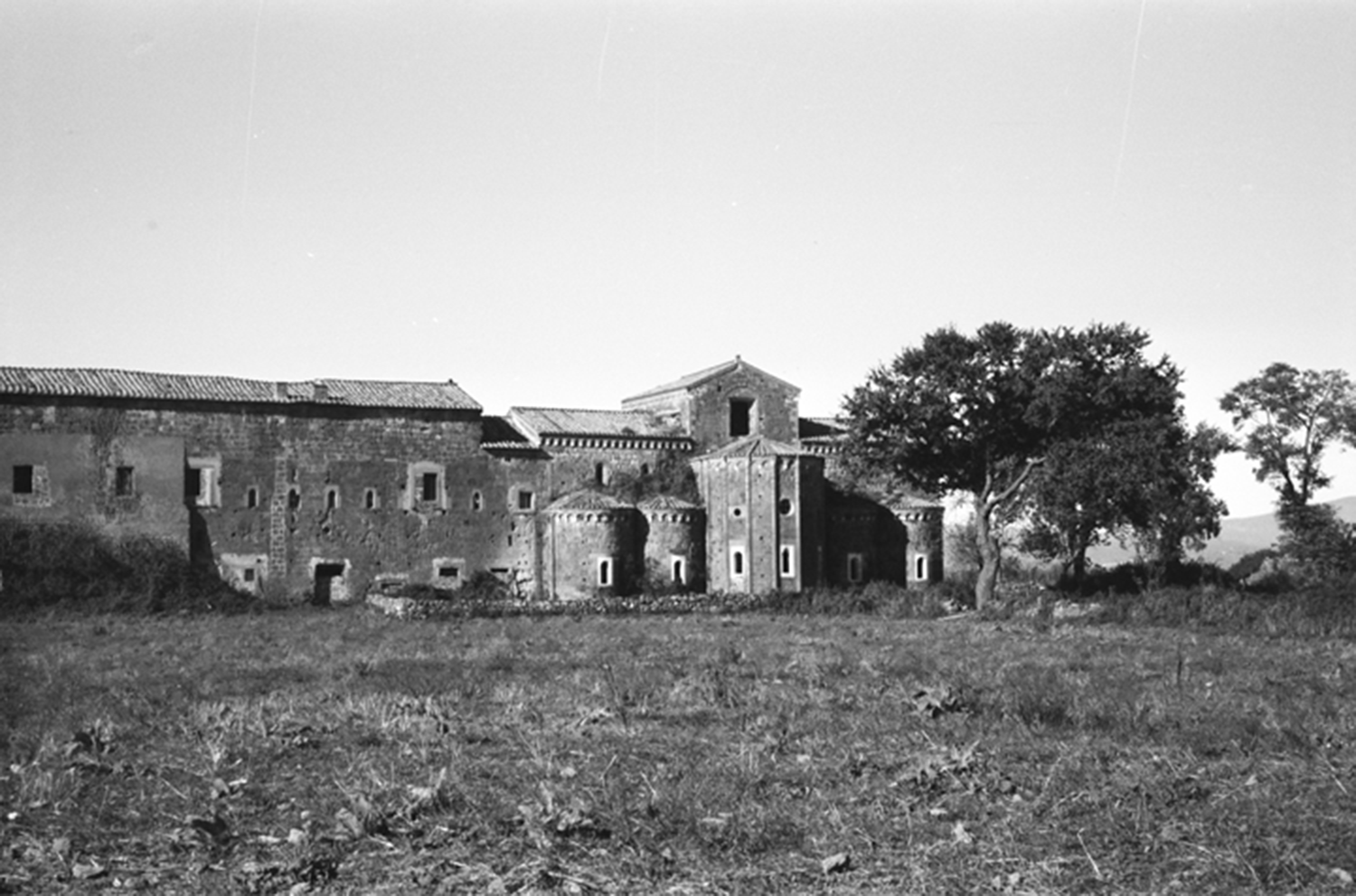
Photo of the church and adjoining abbey of Santa Maria di Falleri, taken by John Ward-Perkins c. 1957 (BSR Photographic Archive, John Bryan Ward-Perkins Collection, wpset-0295.06).
5. FUTURE PROSPECTS AND COMMUNICATION OF RESULTS
The immediate goal of this phase of the project is to carry out five seasons of excavation, from 2022 through to 2026, and then turn to processing and publishing the results of that work. Thus, 2023 will see the third campaign of the FNP on-site, and the second season of stratigraphic excavation, which will expand from the results of 2022. Trenches planned at both the macellum and domus will extend the limits of the first year's areas, whilst another trench is planned over a new area targeting potential multifunction commercial and domestic spaces north of the forum, as identified by the preceding geophysical surveys. This year will also see the finalization of the interpretative mapping of the GPR data from intramural surveys by teams from Ghent and Cambridge in 2015–17 and 2021. A continued campaign of hand augering in systematic transects and select parts of the urban area will add further data with the ultimate goal of creating an historical Digital Terrain Model (DTM) for the entire intramural site. The augering campaign employs Eijkelkamp hand augers with a theoretical maximum achievable depth of c. 15 m (Berendsen, Reference Berendsen2005). Locations and starting elevations of boreholes are recorded with GIS, and various characteristics including texture, sorting, colour, boundary characteristics, and presence of organic and artificial inclusions are recorded for retrieved sediments. The campaign will complete a series of auger holes along north–south and east–west transects across the site, at an interval of c. 50 m, with a denser distribution of 25 m in the central area of the forum.
The DTM, essential for understanding the original microtopography and ground levels of the urban centre during the period between the foundation and abandonment of the Roman city, holds the potential to create a basis for spatial modelling of internal communication and visibility, and ultimately for three-dimensional (3D) visualizations of the town's landscape at different points in time. It also contributes to our aims of understanding historic excavations and reassessing areas already excavated (above). To achieve this, we are ideally situated to integrate recent developments in software that combine disparate data sources (e.g. archival research, geophysical survey, stratigraphic excavation, structural and environmental analysis, coring) in a GIS environment by using, for example, the Rome Transformed 3D toolkit (RT3D) developed by the University of Florence (Bologna and Azzari, Reference Bologna, Azzari, Haynes, Ravasi, Kay, Piro and Liverani2023).
Pursuant to the project's intellectual goals, the FNP also plans to expand in other directions in both the near and long term. As noted among the research aims, we intend one area of future focus to be the immediate periurban districts outside the walls, where a programme of work can help illuminate the city's place in its wider landscape. Already in 2022, GPR prospection was carried out in the area immediately south of the walls, confirming the presence of a large suburban villa and a series of structures relating to the economic exploitation of periurban spaces, such as possible Roman field systems, local roads, and quarries. Interpretative mapping of the resulting high-resolution GPR data from an area of some 6 ha will add to the understanding of this less studied part of Falerii's extramural periurban space. New GPR surveys are planned here in 2023, while other extensive non-invasive investigations (e.g. magnetometry surveys) will be carried out in all the fields around the city-walls where no previous geophysical investigations have taken place; these will be undertaken as part of a doctoral thesis on the periurban area of Falerii Novi. This programme of field survey, combined with other remote-sensing applications (e.g. LiDAR, multispectral imaging), by the teams from the BSR and the Universities of Ghent and Florence aims to acquire new data that will aid in the reconstruction of settlement in the wider territory around the city.
Communication of research results will come, first of all, through a programme of scholarly publication. Publication aims inform the entire documentation and interpretative process from excavation and data collection through to preliminary reports and then to final publication. Currently, FNP members are experimenting with a digital scheda developed for the cloud collaboration software Airtable as a born-digital way of documenting stratigraphic units in the course of their excavation. The multi-institutional nature of the project also urges consideration of information sharing, with the creation of a web-based collaborative platform using Microsoft SharePoint and the eventual aim of hosting open-access resources on a publicly available website now under development. Brief annual communications of work in progress are intended to continue in this journal's field reports section (Bernard et al., Reference Bernard, Andrews, Ceccarelli, Dodd, Kay, Leone and Vermeulen2022; Andrews et al., Reference Andrews, Bernard, Ceccarelli, Dodd, Fochetti, Kay and Vermeulen2023), supplemented by occasional longer reports in other venues. The FNP intends to present results of the intramural excavations in a multi-authored final publication, which will serve to present data and offer synthesis following up on intellectual questions posed in the present paper.
The FNP seeks not only to disseminate its results through traditional academic outputs but also intends to embed local and regional communities as well as public media into its communication strategy. Already in the first year of excavations, the project facilitated numerous site visits from local stakeholders, the public and both Italian and international student groups. In June 2022, this culminated in a public open day, attended by members of nearby communities, civic leaders from Fabrica di Roma, Civita Castellana and Viterbo, representatives from the Museo Archeologico dell'Agro falisco — Forte Sangallo and the Soprintendenza Archeologia, Belle Arti e Paesaggio per la provincia di Viterbo e per l'Etruria Meridionale. Project leaders have similarly discussed plans and progress at a variety of both academic and more general events, contributed public media articles, fielded requests from media and journalists, resulting in a range of online and print news articles, and discussed fieldwork results on national radio.Footnote 12 Working closely with guidance from local constituents, we also hope to develop longer-term ways of promoting the site's contribution to cultural heritage that can endure beyond the project's active lifetime. In this manner, we aspire to make the FNP an accessible archaeological project that offers learning opportunities for both the scholarly community and a wide range of interested public in Italy and abroad.
6. THE CONTRIBUTION OF THE FALERII NOVI PROJECT TO THE STUDY OF ROMAN URBANISM
The site of Falerii Novi presents a considerable opportunity to study urban history in Italy over the long term, spanning the Roman and post-Roman periods. In general, the overarching contribution that the research programme described here intends to make might be viewed as one of an extension of the ways in which we have understood and approached Roman urbanism. Over the coming years, this extension will unfold along multiple, interconnected axes. First, we intend our project to build upon the firm basis of results from prior work on the site and its territory. In particular, this means using Falerii Novi as a sort of laboratory for integrating site-scale survey with targeted excavation and archival research. The FNP hopes to capitalize on the success of past survey, marrying the strengths of this methodology with the chronological resolution afforded by stratigraphic excavation to create a more holistic picture of urban development. Second, this combination intends to provide a picture of a city that is more spatiotemporally extensive than is perhaps customary to a previous generation of researchers studying Roman urbanism. We intend to understand the built and human environments of Falerii Novi as they developed over a long period of time, and we intend to contextualize this urban community within the study of its wider landscape, again leveraging the special opportunities presented by past research by the BSR in this part of the Tiber Valley. An abiding interest among the FNP's members has to do with bringing the tools of landscape archaeology to bear on an urban site, which in turn becomes interpretable as an integral part of its broader setting. In temporal terms, our diachronic project is keenly interested not only in the relatively compressed period of the Roman Imperial city, but in longer-term occupation patterns, as well as in the ‘oscillating’ relationship between the site and nearby Falerii Veteres over several millennia. Third, these spatiotemporal extensions in our positioning of urban archaeology intend to draw in turn upon methodological extensions. This extension especially applies to the project's embrace of archaeological and environmental science and its use of a panoply of scientific methodologies in both fieldwork and post-excavation analyses. The FNP aims to study an ancient city as more than just an assemblage of monumental buildings, infrastructure and objects; it seeks to collect and analyse pollen, animal, charcoal, seeds and all the various more ephemeral residues of human activity. Fourth, as this interest in turn would suggest, the sorts of activities that the FNP hopes to illuminate are not only those which occupied elite spaces. Rather, we intend to extend the view of urban archaeology in premodern Italy to encompass a wider socio-economic segment of society and activities. In these ways, we hope the FNP will ultimately help write the sort of extensive urban histories that can contribute to those trends now reshaping our understanding of urban life in Italy and the wider Mediterranean world.


 Open access