


Introduction
North-eastern Iran is regarded as one of the pioneering regions in Iranian Palaeolithic research, having yielded substantial evidence for Pleistocene (2.58 million years ago (mya)–11.7 thousand years ago (kya)) occupations (McBurney Reference McBurney1964; Ariai & Thibault Reference Ariai and Thibault1975; Sadraei et al. Reference Sadraei2021; Mirzaye & Sadraei Reference Mirzaye and Sadraei2024; Sadraei Reference Sadraei2025). The region is largely separated from the interior of Asia by the Kopet-Dagh and Aladagh mountain ranges, while the Central Iranian Desert divides it from the western sectors of the Iranian Plateau. Permanent river systems such as the Atrak, Kashafrud and Kalshur, together with abundant lithic raw materials including quartz, flint and, in some cases, sandstone and tuff, would have enhanced the attractiveness of this region for Pleistocene human groups. In combination with its strategic geographic position—effectively linking the Iranian Plateau with Central Asia—these factors have led some scholars to characterise north-eastern Iran as one of the most important corridors for hominin dispersal between these two regions (Derevianko Reference Derevianko2024). Nevertheless, previous research has predominantly concentrated on eastern sectors, particularly the Kashafrud and Nishapur plains, while regions now located within North Khorasan Province have remained largely unexplored.
Recent investigations in this province, which also forms the eastern margin of the Central Iranian Desert, now bridge the archaeological gap between north-central and north-eastern Iran, thereby improving our understanding of Palaeolithic settlement dynamics along the desert margins.
Palaeolithic survey
During the Palaeolithic survey of the Esfarayen Plain project in 2025, an area of approximately 7000km2 within the Esfarayen Plain was systematically surveyed (Figure 1). The plain is bound by the Central Iranian Desert to the west, the Sabzevar–Nishapur plains to the east and the Aladagh highlands to the north. Settlement in this region developed along a river system that constitutes one of the principal water sources supplying the interior sectors of the Central Desert (Figure 2). Field surveys were focused on areas with the highest potential for site formation and preservation, particularly zones less affected by Holocene sedimentation (i.e. in the past 12 000 years). Accordingly, gorges and low-elevation hills overlooking rivers and drainage channels were selected as primary target areas. A locality was recorded only when a surface lithic assemblage exceeding fifteen artefacts with diagnostic characteristics attributable to at least one Palaeolithic phase was identified. Artefact collection was conducted primarily through random sampling to minimise surveyor bias.
A) Location of the Esfarayen Plain in relation to other reported Palaeolithic localities and the main corridors of hominin dispersal into north-eastern Iran; B) newly identified localities (figure by A. Sadraei).

Examples of the landscape of the Esfarayen Plain (figure by A. Sadraei).

Results
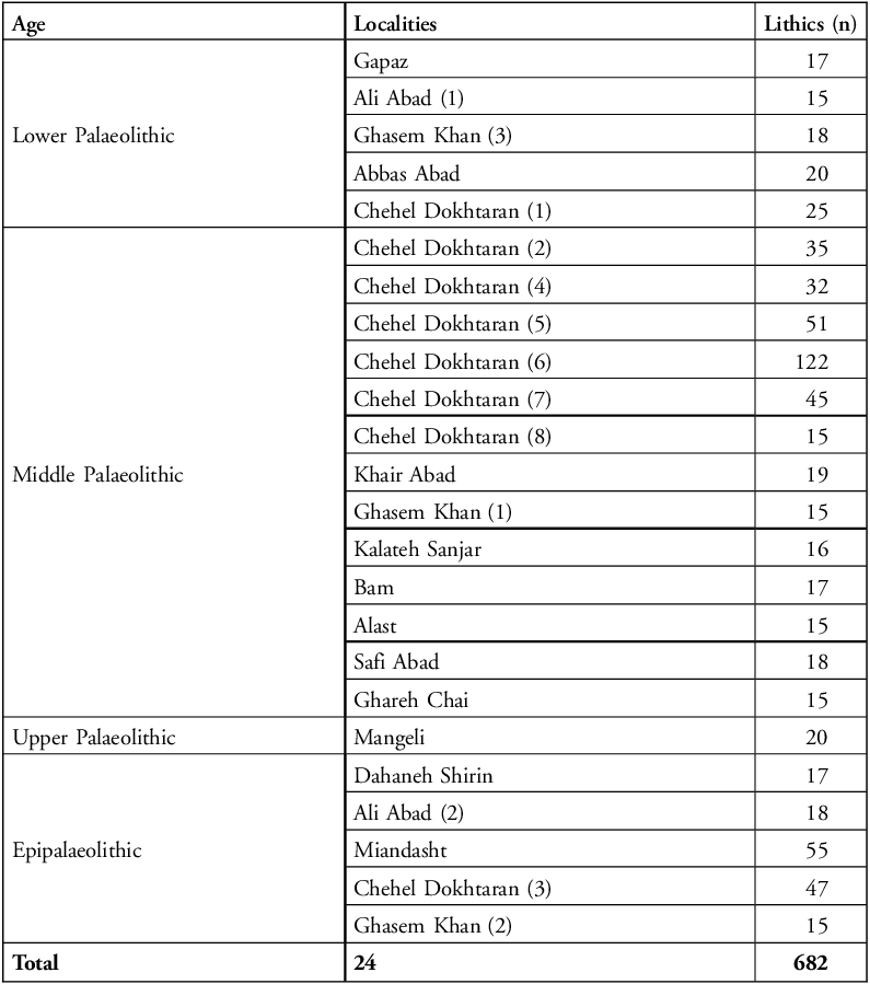
Twenty-four Palaeolithic localities were identified across the Esfarayen Plain (Figure 1 & Table 1). These are predominantly situated on slopes overlooking the Kalshur River, and all are open-air sites. A substantial proportion of the assemblages can be attributed to the Middle Palaeolithic (300–40 kya), represented at 13 localities. Lower Palaeolithic (1 mya–300 kya) and Epipalaeolithic (20–12 kya) materials are identified at five localities and Upper Palaeolithic (40–20 kya) characteristics are tentatively identified at one locality. The largest and most concentrated cluster of localities occurs in the Chehel Dokhtaran region, in the western sector of the study area. Proximity to water resources, combined with the abundance of basalt and flint raw materials, probably contributed to the density and spatial extent of occupations in this part of the Esfarayen Plain.
Palaeolithic assemblages in the Esfarayen Plain.

Table 1 Long description
A table summarizing lithic counts, localities, and ages of Palaeolithic assemblages in the Esfarayen Plain. The table has three columns: Lithics (n), Localities, and Age. It contains 24 rows of data and one row for totals. Row 1: Lithics, 17; Localities, Gapaz; Age, Lower Palaeolithic. Row 2: Lithics, 15; Localities, Ali Abad (1); Age, Lower Palaeolithic. Row 3: Lithics, 18; Localities, Ghasem Khan (3); Age, Lower Palaeolithic. Row 4: Lithics, 20; Localities, Abbas Abad; Age, Lower Palaeolithic. Row 5: Lithics, 25; Localities, Chehel Dokhtaran (1); Age, Middle Palaeolithic. Row 6: Lithics, 35; Localities, Chehel Dokhtaran (2); Age, Middle Palaeolithic. Row 7: Lithics, 32; Localities, Chehel Dokhtaran (4); Age, Middle Palaeolithic. Row 8: Lithics, 51; Localities, Chehel Dokhtaran (5); Age, Middle Palaeolithic. Row 9: Lithics, 122; Localities, Chehel Dokhtaran (6); Age, Middle Palaeolithic. Row 10: Lithics, 45; Localities, Chehel Dokhtaran (7); Age, Middle Palaeolithic. Row 11: Lithics, 15; Localities, Chehel Dokhtaran (8); Age, Middle Palaeolithic. Row 12: Lithics, 19; Localities, Khair Abad; Age, Middle Palaeolithic. Row 13: Lithics, 15; Localities, Ghasem Khan (1); Age, Middle Palaeolithic. Row 14: Lithics, 16; Localities, Kalateh Sanjar; Age, Middle Palaeolithic. Row 15: Lithics, 17; Localities, Bam; Age, Middle Palaeolithic. Row 16: Lithics, 15; Localities, Alast; Age, Middle Palaeolithic. Row 17: Lithics, 18; Localities, Safi Abad; Age, Middle Palaeolithic. Row 18: Lithics, 15; Localities, Ghareh Chai; Age, Upper Palaeolithic. Row 19: Lithics, 20; Localities, Mangeli; Age, Upper Palaeolithic. Row 20: Lithics, 17; Localities, Dahaneh Shirin; Age, Epipalaeolithic. Row 21: Lithics, 18; Localities, Ali Abad (2); Age, Epipalaeolithic. Row 22: Lithics, 55; Localities, Miandasht; Age, Epipalaeolithic. Row 23: Lithics, 47; Localities, Chehel Dokhtaran (3); Age, Epipalaeolithic. Row 24: Lithics, 15; Localities, Ghasem Khan (2); Age, Epipalaeolithic. Row 25: Lithics, 682; Localities, 24; Age, Total.
Discussion
Field surveys in the Esfarayen Plain have produced the first documented evidence from this region of chopping tools attributed to the Lower Palaeolithic lithic industries found east of the Central Iranian Desert (Hashemi et al. Reference Hashemi2024) (Figure 3). Five localities are characterised by chopper cores, unifacial cores, polyhedrons, anvil cores and heavy-duty scrapers, comparable to Lower Palaeolithic assemblages from the Jovin, Nishapur plains and Kashafrud basin, as well as certain Central Asian sites, such as Kul’dara (Ranov et al. Reference Ranov1995; Sadraei et al. Reference Sadraei2021; Mirazaye & Sadraei Reference Mirzaye and Sadraei2024; Sadraei Reference Sadraei2025).
Lower Palaeolithic lithics in Esfarayen Plain: 1) chopper-core; 2) bidirectional core; 3) large flake (figure by A. Sadraei).

A greater number of Middle Palaeolithic localities are identified, almost half of which are situated around the Chehel Dokhtaran highlands. The dominant technological character of the Middle Palaeolithic assemblages aligns closely with industries documented in adjacent regions of the Central Iranian Plateau and north-eastern Iran, and is largely centred on Levallois technology (Figures 4 & 5).
Middle Palaeolithic cores in Esfarayen Plain: 1) Levallois point core on flake; 2–4) centripetal cores (figure by A. Sadraei).

Middle Palaeolithic cores in Esfarayen Plain: 1) Elongated flake with dihedral platform; 2) single-side scraper; 3) single-side scraper on Levallois flake (figure by A. Sadraei).

Levallois and centripetal cores, along with Levallois products and, in some cases, Levallois points constitute the most frequent artefact categories. In contrast to the northern margin of the Central Iranian Desert, where key Upper Palaeolithic sites have been reported (Vahdati Nasab & Clark Reference Vahdati Nasab and Clark2014), assemblages from this period are limited in the Esfarayen Plain. However, at least five localities yielded assemblages exhibiting affinities with Epipalaeolithic lithic industries. The presence of geometric tools, nail scrapers, blade and bladelet cores, and their associated products, are among the defining technological traits of these assemblages (Figure 6).
Upper and Epipalaeolithic lithics in Esfarayen Plain: 1) carinated core; 2) bladelet core; 3 & 4) retouched bladelet; 5) bladelet; 6) thumbnail scraper; 7) geometric (figure by A. Sadraei).

Conclusion
These newly identified sites fill a critical information gap concerning one of the principal routes to occupation of the north-eastern Iranian Plateau—and, by extension, Central Asia—by Middle Pleistocene (7.8–126 kya) hominin populations. The volume of recovered artefacts demonstrates that much of the perceived absence of a Palaeolithic presence along the eastern margin of the Central Iranian Desert is largely attributable to the lack of systematic, specialised research in this region. Continued investigations, particularly targeted excavations at key sites, have the potential to substantially clarify this issue and to yield a more comprehensive understanding of hunter-gatherer adaptations in this sector of the Iranian Plateau.
Funding statement
This research was supported by the Cultural Heritage, Tourism and Handicrafts General Office of North Khorasan Province under Research Contract No: 404/21/1829 for the Paleolithic survey of the Esfarayen Plain.
Author contributions: CRediT categories
Ali Sadraei: Conceptualization-Equal, Data curation-Equal, Formal analysis-Equal, Investigation-Equal, Methodology-Equal, Project administration-Equal, Resources-Equal, Software-Equal, Supervision-Equal, Validation-Equal, Visualization-Equal, Writing - original draft-Equal, Writing - review & editing-Equal. Mahya Azar: Project administration-Supporting, Writing - original draft-Supporting. Javad Khodadoust: Data curation-Supporting.




 Open access

