


The widespread destruction of archaeological sites and features in the United States combined with the displacement of Native American communities has resulted in a thin archaeological record that suffers from both misreadings and an overall lack of recognition of archaeological features. Rapid advances in archaeological technology and techniques are dramatically increasing our ability to identify otherwise inaccessible or invisible archaeological features (Casana Reference Casana2021; Howey et al. Reference Howey, Sullivan, Burg and Palace2020; McLeester and Casana Reference McLeester and Casana2024; Sea and Ernenwein Reference Sea and Ernenwein2020). Alongside technological advances, increased collaboration with Indigenous stakeholders has refocused archaeological projects and highlighted previously hidden histories. In particular, collaborative efforts with descendant communities have identified archaeological sites and features that were otherwise obscured from or overlooked by traditional methods (e.g., Atalay Reference Atalay2012; Cipolla et al. Reference Cipolla, Quinn and Levy2019; Fowles et al. Reference Fowles, Arterberry, Montgomery, Atherton, Douglass and Graves2017; Howey Reference Howey2025; Silliman Reference Silliman2008; Sloan Reference Sloan2020; Walder et al. Reference Walder, DeFoe, Creese, Reetz and Sperling2024). These efforts are yielding exciting advances in locating and documenting archaeological sites.
Our collaborative research approach employed here combined emerging geospatial technologies with oral histories and landscape observations by individuals from the Menominee Indian Tribe of Wisconsin, which led to the documentation of an exceptional archaeological feature that we interpret as a megalith depiction of a Menominee legend. We used drone-acquired lidar and 3D photogrammetry to document the megalith, which is located within the Menominee Reservation in northeast Wisconsin. Three distinct stone works portray the conclusion of a battle between two supernatural beings, a Thunderbird and a Serpent. Megalithic constructions like this one and its interpretation as a depiction of a Menominee legend are extremely rare in North America. However, similar features have been previously documented in the western Great Lakes and beyond, and it is likely that other similar features have been destroyed or simply remain unrecognized within the archaeological community. Efforts described here illustrate the importance of collaborative archaeological projects in locating and interpreting unique and meaningful archaeological features.
Legend of the Dells, the Battle of the Thunderbird and Serpent
It was said that long ago there was a battle that took place here on the Wolf River, and it was between the Thunderbird of the good and the Serpent, the evil one. It was said that the Serpent was trying to make it so that he would be here forever, and the Thunderbird, of course, was for the good. It was said that there was a battle between the Serpent and the Thunderbird at what is now at the Wolf River Dells. This battle took place for several days on end. The Thunderbird would be winning, and the next thing, the Serpent would be winning. But finally, the Thunderbird had won, and he drove the Serpent into the rocks at the sides of the Dells. And the Serpent is there right now. It is said that every spring of the year when the snow melts, in the Springtime, the Serpent tries to come out when the water is high. And the Thunderbird sees that and brings the lightning and thunder and drives the Serpent back so he can’t get out. But he always tries to get out (as told by David Grignon on October 22, 2024).
Menominee Reservation and Feature Location
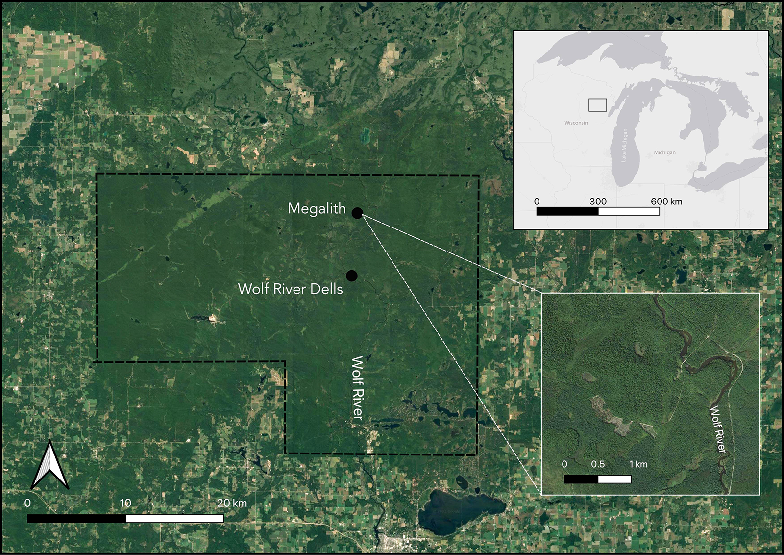
Located in the western Great Lakes, the Menominee Reservation was established in 1854 in what is now Menominee County in northeast Wisconsin (Figure 1; Beck Reference Beck2002). It is located on ancestral territory yet represents only a small fraction of the Menominee Indian Tribe of Wisconsin’s (MITW) ancestral territory. Among the wide-ranging consequences of maintaining ancestral land, Menominee land management practices include the preservation, care, and interpretation of their archaeological resources. The reservation thus contains thousands of documented archaeological sites, including intact and rare cultural features with surface expression, such as archaeological raised garden beds, house basins, storage features, and burial mounds (McLeester et al. Reference McLeester, Anastasio and Grignon2023; Overstreet and Grignon Reference Overstreet and Grignon2021; Overstreet et al. Reference Overstreet, Warrington, Overstreet, Gartner, Mier and Grignon2020). Many sites can be interpreted alongside emplaced traditional knowledge, including legends and oral histories known to members of the Tribe. This emplaced knowledge enables the recognition of features that otherwise may be overlooked or misinterpreted by those unfamiliar with Menominee history, traditions, and religion.
One such feature is a stone construction that we refer to as a megalith because of its monumental scale and seeming anthropogenic origin. The site was brought to the attention of the non-Menominee authors on this report by Jeff Grignon in 2020. The megalith comprises three separate stone features interpreted as a Thunderbird, Serpent, and an enclosure. It is located along a county highway that runs through the reservation, approximately 1.3 km west of the Wolf River (Figure 1).
Satellite imagery of the densely forested Menominee Reservation with the megalith location and legend story location, Dells. Inset (top) shows location of the Menominee Reservation with the Great Lakes region. Inset (bottom) shows the general location of the megalith location along the Wolf River, which runs through the reservation. Basemaps are Google Satellite and ESRI Gray (map by Madeleine McLeester). (Color online)

Grignon encountered the megalith while surveying archaeological sites on the reservation and recalled the Menominee legend on viewing the enclosure and the serpent. After consulting with the other authors regarding the possibility that the site was archaeological in origin, he returned to it and located the Thunderbird in summer 2021.
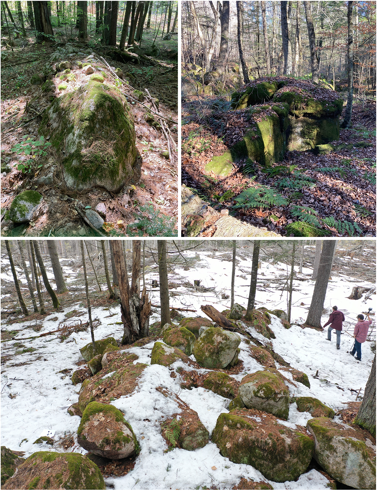
In November 2021, we conducted lidar, photogrammetry, and pedestrian surveys to map the site, gain an aerial view of the feature, determine whether it indeed depicted the legend, and assess its possible anthropogenic origin (Figure 2).
Photographs from the ground of the Serpent (top left) and of the Thunderbird (top right). (Bottom) Drone-acquired photograph of the Thunderbird with people for scale (photos by Madeleine McLeester, Jon Alperstein, Petra Creamer, and Jesse Casana). (Color online)

Methods
Lidar
Lidar surveys were conducted using a DJI Matrice 300 Enterprise-grade drone outfitted with the Zenmuse L1 lidar sensor during leaf-off in November 2021; they were done at this time because the dense canopy at the Menominee Reservation would have interfered with data collection (McLeester et al. Reference McLeester, Ferwerda, Alperstein, Overstreet, Grignon and Casana2025; Schindling and Gibbes Reference Schindling and Gibbes2014). We processed and classified the data using a combination of LAStools, SAGA GIS, and CloudCompare software (see Casana et al. Reference Casana, Fowles, Montgomery, Mermejo, Ferwerda, Hill and Adler2023). We produced bare-earth digital surface models at 10 cm resolution, sufficient to map the features.
Photogrammetry
3D photogrammetry models were created of the three features comprising the megalith. This technique is increasingly used to detail the recording of sites and landscapes (Haukaas and Hodgetts Reference Haukaas and Hodgetts2016; Howland et al. Reference Howland, Kuester and Levy2014; Marín-Buzón et al. Reference Marín-Buzón, Pérez-Romero, López-Castro, Jerbania and Manzano-Agugliaro2021). To model the features, we first cleared loose debris and small branches from the area and placed 25 ground control points (GCP). We mapped the XYZ coordinates of GCPs using an Emlid Reach 2 survey system. We then used a DJI Mavic 2 drone with an onboard camera to collect 1,219 overlapping images while manually flying the drone below the tree canopy. Images were processed in Agisoft Metashape to create two digital 3D models of the megalith components: one of the Thunderbird and another of the Serpent and the components of the enclosure visible on the ground. Additional parts of the enclosure that are outside the photogrammetry survey are visible in the drone lidar results.
The models allow us to illustrate the size and configuration of the individual stones and document the ways in which the features are anthropogenic. These models can be explored further by future researchers encountering similar features and can aid the MITW in its preservation and educational efforts (see Supplementary Material 1 and 2).
Results
We interpret the megalith as being composed of three separate stoneworks: a Thunderbird, a Serpent, and the enclosure that contains the Serpent. Together, they depict the conclusion of the Legend of the Dells, as told by David Grignon (above). We named it the Grignon megalith after our late colleague and coauthor, Jeff Grignon, who encountered and documented it. Each stonework either makes use of the existing, local geological formations and/or was created using the abundant local granite. That said, the head of the snake and its tail may have been procured and brought to the site given their size and shape (i.e., their serpentine features). They are made of the same granite as the rest of the megalith, so they may also be the result of a fortuitous find nearby.
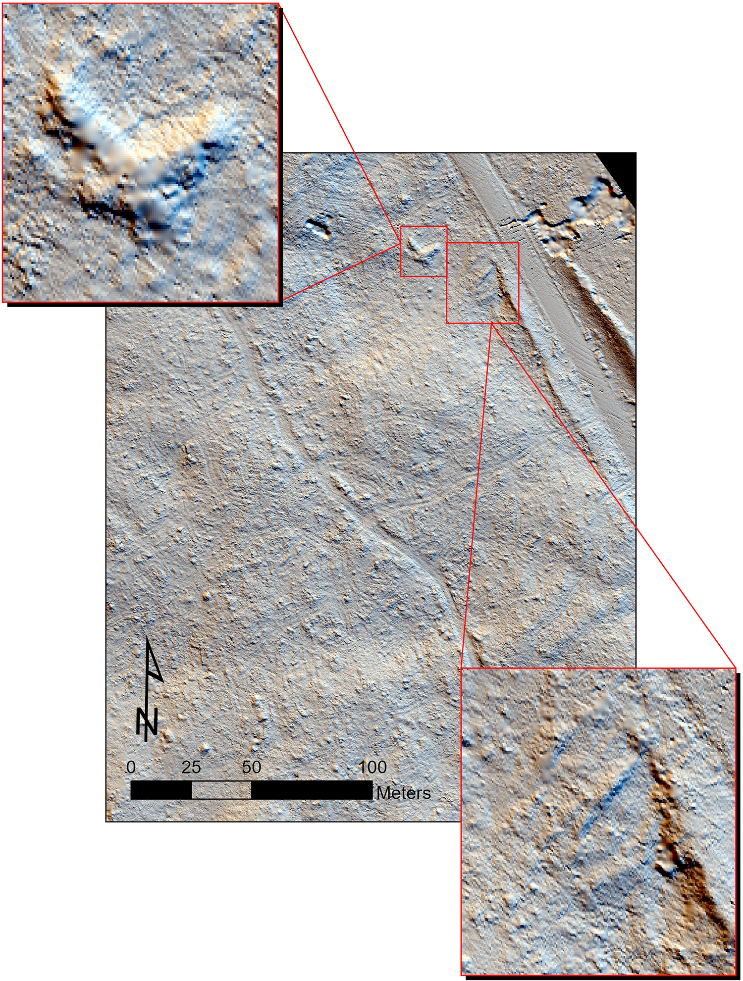
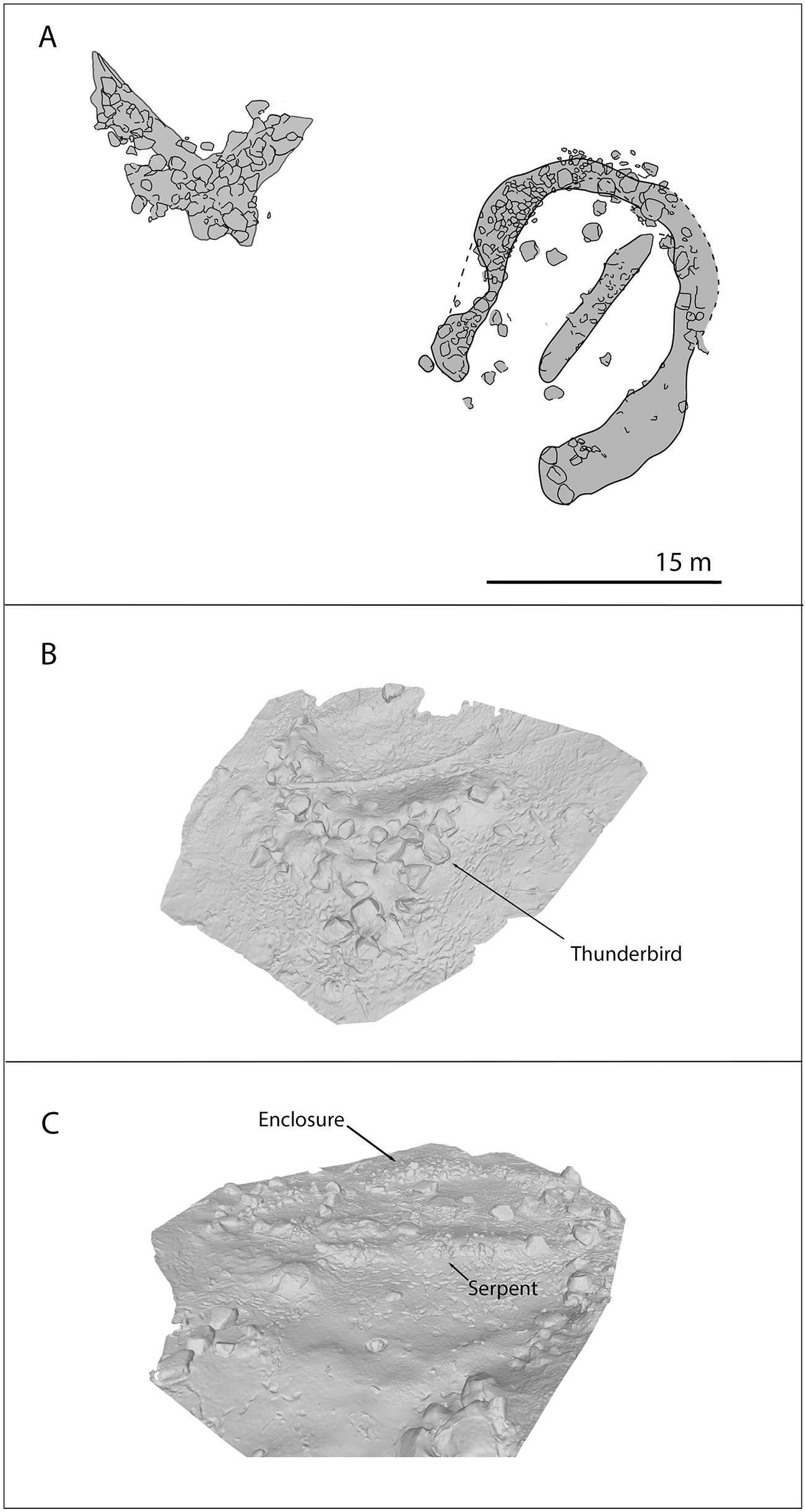
The lidar and photogrammetry results illustrate how natural stone formations, enhanced with local stones, closely portray this Menominee legend (Figure 3 and Figure 4). First, the aerial imagery shows a clear depiction of the Menominee legend: a Serpent is entrapped by an overlooking Thunderbird (Figure 3). Such a close representation is unlikely to be natural because the Serpent is positioned in the near exact center of the circular enclosure. Second, this circular enclosure and Serpent are unlikely to be natural given their shapes (a circle and a straight line). Third, only the tail and head of the Serpent are larger stones, which would otherwise be more uniformly sorted in a natural feature. Fourth, as visible in the lidar, there are no other geometric features within the vicinity. Finally, these features are more closely clustered than natural rock deposits in the area.
Lidar showing the megalith components. The Thunderbird is in the top inset. The bottom inset shows the enclosure surrounding the Serpent (image by A. Chad Hill and Petra Creamer). (Color online)

(A) Sketch of the megalith based on lidar results; (B) snapshot of the Thunderbird photogrammetry model; (C) snapshot of the Serpent and enclosure photogrammetry model. See Supplementary Material 1 and 2 for full models (sketch by Jasper Clayton; photogrammetry by Petra Creamer; composite figure by Madeleine McLeester).

Although we interpret this storied space as anthropogenic, it impossible to determine exactly which stones were moved to create this megalith feature; therefore, we use our best judgment about what may have been possible through natural processes versus efforts by ancestral Menominee individuals. We interpret the Thunderbird as a largely natural feature, because it shows no indication of being moved and reflects the general shape and erosional properties of other nearby natural granite features. It is also made of several exceptionally large boulders. Stones near the base of the Thunderbird are mostly made of smaller stones and may have been moved there. The stacked smaller stones of the Serpent and enclosure, which most closely resemble stone walls, convinced us of the anthropogenic nature of these two features.
Thunderbird
The Thunderbird is the largest of the three stoneworks. It measures approximately 16 m wide, 12 m long, and approximately 3.5 m tall. The Thunderbird is composed mostly of a natural granite formation; directly beneath it are a series of boulders that may have been added to enhance this natural formation to enhance the narrative aspect of this otherwise natural formation. From the aerial view we interpret this boulder configuration as both representing the Thunderbird carrying the Serpent into the enclosure and giving the appearance of the Thunderbird in flight. The combination of the stone formation’s natural shape and its proximity to the legend’s origins likely explain why this location was chosen.
Serpent
The Serpent measures approximately 11 m long, 2 m wide, and 1 m high. Its head is composed of a single, seemingly unworked stone with natural serpentine features (see Figure 2). This stone seems to have been selected for its resemblance to a snake head and perhaps was moved to this location. Similarly, the tail of the Serpent is a single, larger triangular stone that ends in a point. As with the head, it may have been selected and moved here because it looks like the tail of a snake. The stones forming its body are smaller, ranging from about 20 cm to 50 cm in width; when stacked together, they present like a stone wall. In fact, without paying attention to the head and tail stones, this feature could be easily mistaken for a stone wall. Yet, unlike a stone wall, there is an undulating aspect along the top of the snake’s body and the individual stones provide a snakeskin-like texture. Importantly, the arrangement of head and tail stones on the Serpent and the placement of the Serpent in the middle of the enclosure demonstrate that this feature is anthropogenic.
Enclosure
The enclosure encircles the Serpent, with a circumference of approximately 21 m in its exterior dimensions and 16 m for the interior. It is about 0.5–0.75 m high and is made of stones of varying sizes. Part of the enclosure was damaged by construction of the county highway. The circular shape and position of the enclosure around the centered Serpent support our argument that this feature is anthropogenic.
Surface Survey
A pedestrian surface survey was conducted around the megalith to determine whether surface finds could help date it. No excavations or shovel testing were conducted as part of our survey, nor were any previously undertaken here. Over the course of the survey, we observed very little trash, which is typical for archaeological sites at the reservation, nor did we see any artifacts related to the construction of the megalith. The only relevant artifact found was a rusted pail with a modified handle, which was resting on the surface and located near the Serpent. This item might have been used for maple syrup collection/production, a popular activity in this densely forested setting, or it may have been left as an offering of maple syrup or other material. It was not collected and appears to significantly postdate the construction of the megalith, based on the moss and other vegetation that have accumulated on the surface of it. Because we did not encounter any other artifacts during the surface survey, it was impossible to determine the date of construction.
Discussion: Monumentality in the American Midwest
The Grignon megalith described here is not the only documented Menominee narrative expressed in stone. For instance, Hoffman (Reference Hoffman1896:38–39, 118–119) documented a large, tan-colored stone near Keshena that is thought to represent an ancestor granted eternal life by Manabush, a spiritual figure in Menominee religion. Another version of this story is attached to the Spirit Rock located in Keshena, where the sign erected by the Wisconsin Historical Society (Marker 127) states that Manabush angrily granted eternal life to the ancestor and that “when the rock finally crumbles away the race will be extinct.” In another example, Jeff Grignon during a visit to the reservation showed a natural rock formation to some of the non-Menominee coauthors that is associated with Thunderbirds. He also pointed out a rock face once read by a medicine man along the Wolf River that was destroyed by bridge construction. Relatedly, stones can also be medicines and are included in bundles (Skinner Reference Skinner1921). There are likely many other legends told through stone, but they have not been shared with the non-Menominee authors of this report.
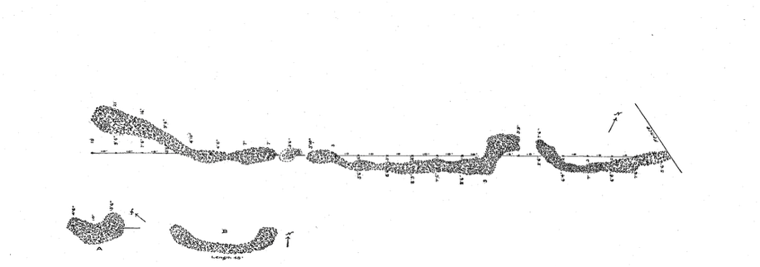
Megalithic effigies, while uncommon, are not entirely unknown in the Great Lakes region. Fox (Reference Fox1922) mapped a megalithic feature built in the shape of a serpent at Eulrich Farm, a ridged agricultural bed site, near Lake Winnebago. Ancestrally, this area is overlapping Ho-Chunk and Menominee ancestral territory (Griffin Reference Griffin1960; Hall Reference Hall and Green1995; Mason Reference Mason1997; Overstreet Reference Overstreet2009; Walder and Hawkins Reference Walder and Hawkins2024). The Eulrich serpent effigy is shaped by stones piled from 15 cm to 60 cm high and measures 67 m in length. Fox (Reference Fox1922) also mapped two smaller, semicircular constructions at Eulrich Farm, but whether and how they are associated with the serpent effigy is unclear. Additional stone “heaps” are identified within the garden beds (Fox Reference Fox1922), but no other stoneworks are mapped at the site or, to our knowledge, elsewhere in Wisconsin.
Fox (Reference Fox1922) argued that the Eulrich serpent megalith was likely an ancient feature, in part because the Euro-American owners of the farm had no knowledge of the feature, suggesting it predated their 50-year ownership of the land. Additionally, there were trees growing on the surface of the megalith, which Fox (Reference Fox1922) estimated to be at least 100 years old in 1922. The age of Eulrich garden beds have been interpreted as either AD 1000–1300 (Peske Reference Peske1966) or AD 1300–1650 (Overstreet Reference Overstreet1981), but even given that large date range, the megalith’s association with the garden beds is not clear. Nonetheless, this Eulrich Farm megalith is at least 200 years old and likely older (Figure 5).
Stone serpent megalith at Eulrich Farm, identified by Fox (Reference Fox1922:Plate 3; reprinted with permission from the Wisconsin Archeologist).

The Grignon and Eulrich Farm megaliths are the only two stone effigies in Wisconsin of which we are aware, yet significant stone constructions are documented within and beyond the Great Lakes. Outside ancestral Menominee territory but still within the Great Lakes area are many documented stone features (Birmingham and Rosebrough Reference Birmingham and Rosebrough2025; Hinsdale Reference Hinsdale1931). Hinsdale (Reference Hinsdale1931) details several natural formations that are seen as significant to local communities, as well as the presence of stone heaps created to commemorate important events. These features are recognizable because they are surrounded by offerings, including pipes, beads, jewelry, and, reliably, tobacco (Hinsdale Reference Hinsdale1931:105).
Farther afield, ancestral Niitsitapi (Blackfoot Confederacy) stone effigies of the spiritual figure Napi and of narrative human figures that portray historical events are documented throughout the Plains (Vickers Reference Vickers2008). In Ohio, Hopewell-era (about 100 BC–AD 600) stone effigies and enclosures are also documented (Lynott Reference Lynott2014). Most significant to this discussion is a stone outline of a bird inside a circular enclosure, a near inverse of the legend told here. It was excavated at the North Benton Mound in Ohio (Birmingham and Rosebrough Reference Birmingham and Rosebrough2025:65–55) and dates to the late terminal Hopewell era around AD 600 (Carr Reference Carr2021:676). A Hopewell-era stone bird effigy is also found at Sugar Run Mound in Warren County, Pennsylvania (McConaughy Reference McConaughy2011). Other prominent stone effigies include Rock Eagle and Rock Hawk in Putnam County, Georgia. Rock Hawk is enclosed by a stone circle, and Rock Eagle may also have been (Carr Reference Carr2021: 682) in another intriguing inversion of the Grignon megalith. However, considering birds can fly, these examples are not exactly inverse and may tell a similar or different legend. Dates for their construction remain unknown.
Outside of these examples, monumentality across eastern North America is typically expressed through earthen mound construction, which was practiced in a range of forms for several millennia throughout the precolonial era. Ancestral Native American communities constructed myriad monumental earthen constructions that included a range of geometric, animal, and spiritual shapes, as well as conical, tapered, and platform mounds (see Birmingham and Rosebrough [Reference Birmingham and Rosebrough2017] for more information).
The Serpent and Thunderbird components of the Grignon megalith evoke similarity to earthen effigy mounds constructed during the Late Woodland period (AD 700–1100) primarily in what is now Wisconsin. Effigy mounds are associated with the ancestral Ho-Chunk and were typically built as burial mounds depicting supernatural beings, such as water spirits, thunderbirds, serpents, types of birds, and bears (Birmingham and Rosebrough Reference Birmingham and Rosebrough2025; Rosebrough Reference Rosebrough2014). The size of mounds can range from several meters to the greater than 190 m wingspan of the Thunderbird effigy near Lake Mendota, Wisconsin (Birmingham and Rosebrough Reference Birmingham and Rosebrough2017).
As monumental landscapes, effigy mounds are often part of larger mound groups that include conical, tapered, and linear mounds, which together comprise ceremonial spaces. Smaller mound groups can include several mounds, yet the largest mound groups contain hundreds—a radical transformation of the landscape into a ceremonial, meaningful space (Boszhardt Reference Boszhardt1988). The concentration of separate effigy forms at sites appears tied to aspects of the natural landscape, balance as a spiritual concept, and clan affiliation (Birmingham and Rosebrough Reference Birmingham and Rosebrough2017) rather than narratives, as is the case described here. Critically, however, there are often elements of the Upper world, such as Thunderbirds, alongside elements of the Lower world, like Serpents, an aspect of the Grignon megalith.
One effigy feature, documented in the late nineteenth century in southwestern Wisconsin along the Kickapoo River, features a Thunderbird inside an enclosure; it is another intriguing inverse of the legend described here (Birmingham and Rosebrough Reference Birmingham and Rosebrough2025:66), although we could find no known legend associated with it. Now destroyed, this entrapped Thunderbird echoes a similar Hopewell-era earthen bird and enclosure that were mapped at Newark Earthworks in Ohio by Squier and Davis (Reference Squier and Edwin H.1848) and those megaliths noted above (Birmingham and Rosebrough Reference Birmingham and Rosebrough2025).
Although legends like the one described here are not often included in archaeological interpretations of effigy mounds, they have been used to interpret ritual spaces and monumental constructions in the Midwest. For example, in north-central Michigan, Howey and O’Shea (Reference Howey and O’Shea2006) interpret a pair of earthen enclosures, the Missaukee Earthworks (20MA11-12), as a telling of an Ojibwe narrative associated with Midewiwin origins and the travels of Bear (Howey and O’Shea Reference Howey and O’Shea2006; but see Mason Reference Mason2009). Although they similarly highlight a possible narrative inscribed on the landscape, the forms presented here differ in that the enclosures themselves are operating as landscape markers and not the characters themselves—resulting in the interpretive lens doing more heavy lifting. Nonetheless, the Missaukee Earthworks provide another example of a legend inscribed on the landscape, and many other effigy and ritual features could have once held similar meanings that remain lost to modern scholarship.
Conclusion
Currently, the Grignon and Eulrich Farm megaliths remain the only two documented effigy stone constructions in Wisconsin. However, one obvious question arises: How many other megaliths are undocumented?
From the ground, the megalith discussed here is easily mistaken for a natural feature or an historic stone wall, especially by those unfamiliar with the Menominee legend. Thus, it is unlikely that most archaeologists would identify it as a cultural feature and record it, underscoring the critical importance of collaborative projects with descendant community stakeholders.
However, even though the megalith might easily be overlooked on the ground, it is unmistakable from the air. Technological advances in lidar and photogrammetry have made mapping features like these possible and will allow archaeologists to identify similar features in the future. The aerial imagery lays bare the anthropogenic nature of the feature and details aspects of its construction. Methods described here can be applied to other suspected megalith features or in searching for similar features elsewhere.
It is our hope that this report will help highlight a Midwestern effigy feature that has not been in discussion for more than a century and will encourage archaeologists to look for similar megaliths in the future. This megalith demonstrates that monumentality in the midcontinent was expressed through more avenues than currently recognized. Finally, although collaborations like ours are already well underway, the recognition and documentation of megaliths will require Indigenous knowledge sets.
Acknowledgments
This project would not be possible without the support of the Menominee Indian Tribe of Wisconsin, and we are tremendously grateful to them for allowing us to conduct and share this exceptional feature. We are grateful to the Menominee Language and Culture Commission for their review of this report and feedback. We also want to thank Seth Schneider and Connie Arzigian at the Wisconsin Archeologist for providing the permission to reprint the Eulrich Farm Serpent plate. Finally, we want to thank Dave Overstreet for his many years of support of our research, his career dedicated to ancestral Native American archaeology in the American Midwest, and his service to the Menominee Indian of Wisconsin.
Funding Statement
This research was generously funded by the Claire Garber Goodman Fund for Anthropological Research and the Elfrieda Frank Foundation.
Data Availability Statement
All data is stored by the authors and available upon request.
Competing Interests
The authors declare no conflicts of interests.
Supplementary Material
The supplementary material for this report can be found at https://doi.org/10.1017/aaq.2026.10186.
Supplemental Material 1. Photogrammetry model of the thunderbird component of the megalith (obj). Created by Petra Creamer.
Supplemental Material 2. Photogrammetry model of the serpent and enclosure components of the megalith (obj). Created by Petra Creamer.


 Open access

