


Over half a century has passed since Michael Moseley (Reference Moseley1975), among others (e.g., Lanning Reference Lanning1967), challenged the erroneous assumption that coastal environments were marginal to the rise of complex societies predicated on food production (cf. Beresford-Jones et al. Reference Beresford-Jones, Pullen, Chauca, Cadwallader, García, Salvatierra and Whaley2018; Haas and Creamer Reference Jonathan and Creamer2006; Raymond Reference Raymond1981). Archaeological attention has since been duly trained on the capacity of coasts to support human migrations (Erlandson et al. Reference Erlandson, Graham, Bourque, Corbett, Estes and Steneck2007), permanent settlement (Garland et al. Reference Garland, Thompson, Howland, Gragson, Andrus, Demyan and Parbus2025), economic intensification (Boone and Alsgaard Reference Boone and Alsgaard2024), and the rise of stratified societies in the absence of agriculture (Ames Reference Ames1994; Arnold Reference Arnold1992; Marquardt et al. Reference Marquardt, Walker, Thompson, Savarese, Thompson and Newsom2022; Thompson et al. Reference Thompson, Marquardt, Walker, Thompson and Newsom2018). The potential of coastal environments to support large, sedentary populations turned on not only the primary productivity of estuaries, bays, and related marine biomes but also the technological means to take advantage of it. In various places, coastal infrastructure enabling settlement growth and permanence involved mounding of shell and earth (e.g., Schwadron Reference Schwadron2017), construction of fish traps and shellfish gardens (e.g., Lepofsky et al. Reference Lepofsky, Smith, Cardinal, Harper, Morris and Gitla (Elroy White)2015; Thompson et al. Reference Thompson, Marquardt, Savarese, Walker, Newsom, Lulewicz, Lawres, Thompson, Bacon and Walser2020), and digging of canals and related water features (e.g., Thompson et al. Reference Thompson, Marquardt and Walker2014; Waselkov et al. Reference Waselkov, Beebe, Cyr, Chamberlain, Mehta and Nelson2022). All such modifications to coastlines may have been initiated to ameliorate the time-space irregularities of resources subject to short- and long-term changes in water depth, temperature, and salinity, but eventually, in some cases, they became necessary to expand production in response to growing demands for surplus (Boone and Alsgaard Reference Boone and Alsgaard2024).
Along the Gulf coast of Florida, the potential for maritime resources to support large-scale, complex societies is exemplified best by the Calusa (Marquardt et al. Reference Marquardt, Walker, Thompson, Savarese, Thompson and Newsom2022). At the time of Spanish contact in the sixteenth century AD, the Calusa were a stratified society of thousands of people distributed across coastal southwest Florida settlements terraformed with shell and earth to control the flow of tidal water and to elevate otherwise flooded terrain for habitation. At the capital city of the Calusa, on present-day Mound Key, European intruders observed a 51 ha terraformed island replete with a 10 m tall platform mound supporting a massive building. Although the scale and grandeur of Mound Key and other sites of Calusa terraforming were likely intensified by Spanish and French contact (Marquardt Reference Marquardt, Ingold, Riches and Woodburn1988; Marquardt et al. Reference Marquardt, Walker, Thompson, Savarese, Thompson and Newsom2022; Thompson et al. Reference Thompson, Marquardt, Walker, Thompson and Newsom2018), recent investigations document a 2,000-year history of prior settlement during which shell midden accumulated to form the island, much of which was later mined before European contact to build the mound on which large public buildings were constructed (Thompson et al. Reference Thompson, Marquardt, Walker, Thompson and Newsom2018). Notably, this wave of terraforming came after a period of abandonment during a downturn in global temperatures between approximately AD 550 and 800 (Vandal Minimum) that resulted in shoreline regression and diminished nearshore productivity (Marquardt et al. Reference Marquardt, Walker, Thompson, Savarese, Thompson and Newsom2022). The extent to which terraforming at Mound Key after it was resettled around AD 1000 was undertaken collectively to address the vagaries of a maritime economy or to meet the demands of emergent leadership controlling surplus production is uncertain, although the construction of fish traps circa AD 1300–1400 points to the latter (Thompson et al. Reference Thompson, Marquardt, Savarese, Walker, Newsom, Lulewicz, Lawres, Thompson, Bacon and Walser2020). Either way, the construction of mounds, canals, and fish traps realized the promise of intensive coastal settlement but also invited peril by locating fixed infrastructure in places subject to changing water levels.
The Calusa terraformed much of the southwest Florida coast to underwrite a political economy of vast scale, but they were not the only coastal communities to construct infrastructure for the purpose of intensifying production. The history of Indigenous settlement along the Gulf coast of Florida extends back at least 4,500 years, during the Late Archaic period, when sea levels were a few meters lower than at present. With the exception of late period (i.e., post-AD 900) communities of the Tampa Bay area, which were tied into the greater Mississippian world (Mitchem Reference Mitchem, Ashley and White2012), none rose to the level of political complexity of the Calusa. However, after approximately AD 200 in select areas, such as the northern Gulf Coast, civic-ceremonial centers arose at places such as Crystal River (Pluckhahn and Thompson Reference Pluckhahn and Thompson2018) and Garden Patch (Wallis Reference Wallis, Birch and Thompson2018) that involved terraforming of mounds and ridges of shell and earth, some clearly mortuary (Figure 1). Like Mound Key, they were abandoned during the period of sea-level regression (ca. AD 600–800), and some reoccupied afterward, but eventually they were abandoned altogether long before Europeans arrived. Unlike the Calusa, and in the absence of historical benchmarks, there is little to recommend that early civic-ceremonial centers of the northern Gulf Coast were constructed at the behest of persons vying to control the production and distribution of surplus. Rather than a matter of political economy, the motivations for terraforming were arguably a matter of ritual economy (sensu McAnany and Wells Reference McAnany, Wells, Christian Wells and McAnany2008; Spielmann Reference Spielmann2002). Differences between the two in terms of surplus production and the labor it required may be inconsequential in many respects, but in terms of timing and siting, ritual economies are structured by calendars and landscapes that were not necessarily in sync with the most opportune times and places to take advantage of “natural” abundance (cf. Wiessner Reference Weissner, Dietler and Hayden2001). Rituals tied to solar standstills, for instance, may not have coincided with peak production and availability of marine resources in support of large-scale feasting.
Locator maps of the greater region (left), showing locations of select coastal and interior civic-ceremonial centers dating to the first millennium AD; and the study area (right) of the Lower Suwannee Archaeological Survey (Sassaman et al. Reference Sassaman, Wallis, McFadden, Mahar, Jenkins, Donop and Monés2017), showing locations of all sites on record, particularly sites with mounds, and Richards Island, the location of a tidal fish trap.

One early civic-ceremonial center on the northern Gulf coast of Florida is known today simply as Shell Mound (8LV42; Figure 2). Between about AD 400 and 650, Shell Mound was the settlement of a residential population that hosted large gatherings of people from across the region during the time of summer solstices (Sassaman et al. Reference Sassaman, Blessing, Goodwin, Jenkins, Mahar, Boucher, Barbour and Donop2020). Unsurprisingly, among the resources collected from estuarine waters to provision summer solstice feasts were fish, particularly mullet. Large pits containing the remains of summer solstice feasts include abundant bone from mullet of similar size, suggesting that they were captured en masse (Mahar Reference Mahar2019). Historically, mullet harvests in the area took place in the fall, when fish of this species aggregated at the mouth the Suwannee River for spawning runs into the Gulf of Mexico (Earll Reference Earll and Good1887). Collecting large numbers of mullet during the summer would have required a different strategy because the fish are dispersed into smaller schools, and they are closer to shore and up the river, foraging voraciously in preparation for fall spawning runs.
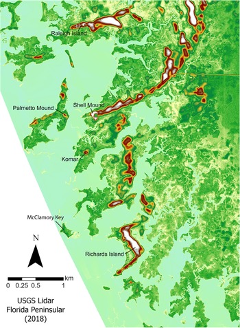
Digital elevation model of the area encompassing major sites of habitation, ritual gatherings, and mortuary contexts in proximity to Richards Island using USGS Lidar, Florida Peninsula, 2018. (Color online)

The remains of a tidal fish trap 2 km south of Shell Mound, on Richards Island, attest to one means of mass fish capture that we argue was built and used in the service of summer solstice feasts at Shell Mound. Details of the fish trap were first issued in an open-access technical report (Sassaman et al. Reference Sassaman, Barbour, Blessing, Boucher, Donop, Duke, Goodwin, Jenkins, Mahar and Monés2019), as was the evidence for summer solstice feasting at Shell Mound (see also Goodwin et al. [Reference Goodwin, Sassaman, Blessing and Steadman2020] and Sassaman et al. [Reference Sassaman, Blessing, Goodwin, Jenkins, Mahar, Boucher, Barbour and Donop2020] for broader context). Here, we examine in greater detail the use life of the fish trap in the context of first rising and then falling sea level. This effort is enabled by high-resolution drone-mounted lidar data; in particular, accurate elevational data for comparing tidal ranges to components of the trap—specifically, its seawalls, channels, and tidal pools. Collected at low tide, lidar data also enable detection of now-submerged shell rings dating to the Vandal Minimum. These data also provide the first definitive measure of how far sea level fell during this period (>100 cm) and, by extension, reveal the level below which the fish trap was no longer serviceable. Obviously, as a tidal fish trap, the magnitude and rhythm of tides set limits on its use. Less obvious is how its use was affected by changes in relative sea level, and thus absolute tidal range, over the span of decades or centuries of change. Comparing the elevations of the fish trap today to tidal projections over a century, we infer that as currently configured, the fish trap would have been reliable every year in mid- to late June—the time of summer solstice—as it would throughout most of the year. With a 50 cm drop in sea level, the trap would have been reliable in mid- to late June only every fourth year, when spring tides (+40 cm mean high tide) coincided with summer solstices. Another 50 cm drop in sea level would have put the fish trap out of mean tidal range at any time of the year.
We begin with a summary of the form and function of the Richards Island fish trap and the evidence connecting it to summer solstice feasts at Shell Mound. We then take a closer look at the relationship between the trap and tidal range today, using data from the past century to model annual and multiannual cycles. Modeling lower sea level based on the elevation of semi-submerged shell rings, we infer a trend of decreasing annual reliability of trapping fish in tidal water and propose potential effects for sustaining settlement and summer solstice feasts at Shell Mound. Implicated are aspects of history and cosmology well documented for the area that take us beyond the mass capture of fish. Ultimately, we aim to show how the construction of this fish trap fulfilled the promise of ritual gatherings involving public feasts but imposed constraints on sustainability by fixing the relationship between the shoreline and tides with large-scale, stationary infrastructure.
Richards Island Fish Trap
The Richards Island fish trap is a complex of tidal pools connected by channels in the blowout of a relict parabolic dune that is flooded and drained by a single tidal channel flanked by two oyster shell seawalls (Figure 3). The complex measures roughly 250 m long (north–south) and 100 m wide (west–east). The top of the oyster shell seawall is approximately 1.85 m higher than the basal elevation of the tidal pools. Since 2013, we have observed fish move in and out of these pools with the tides, and we can attest to their potential for mass harvest as currently configured.
Digital elevation model of the Richards Island fish trap (GatorEye Lidar, January 22, 2022, at low low tide, −0.12 m). (Color online)

Relative to tidal flow (see below), the topography of the fish trap puts limits on the volume and depth of water that enters and gets trapped in tidal pools. Precise elevations are therefore critical to assessing the range of tolerance of the trap to changing water levels. Topographic data collected by Total Station in 2015 were superseded in January 2022 by high-resolution drone-mounted lidar,Footnote 1 a digital elevation model (DEM) of which is provided in Figure 3. Annotations of this DEM include labels for the tidal pools, the oyster-shell seawalls, and intertidal oysters in the tidal channel. Brief discussion of each of these features follows.
Of the six pools shown in the DEM of Figure 3, four (1–4) stand out for their size and generally similar morphology. Each is connected to the others by narrow tidal channels. After tidal water recedes, each of these pools holds about 25 cm of water (Figure 4). At this depth of water, the surface area of these four pools ranges from a low of 243.1 m2 (Pool 1) to a high of 622.1 m2 (Pool 3). Two other pools (5 and 6), to the south, are smaller (101.2 and 75.5 m2, respectively) and relatively isolated. Both lie at the terminus of a small channel, abutting the seawall. At low tide they hold water, but only about half as much as the other pools.
View of impounded tidal water in pools of the fish trap from a drone flown on January 22, 2022 at low low tide (−0.12 m), at approximately 10:00 a.m. (Color online)

Focusing on the four larger pools, it is worth noting that each of them—as well as the channels that connect them—has a firm, compacted base. This stands in sharp contrast to the typical mud or “muck” of intertidal flats in open-water shorelines. Presumably, one effect of the seawall is to reduce the amount of sediment that enters the blowout by blunting spring tides and storm surges. It also subdues the flow of tidal water in and out of pools, resulting in pools of water that do not completely drain, which creates opportunities for mullet to feed on diatoms found in detritus and decomposing plant matter.Footnote 2 Dividing each of the pools are berms of oyster shell and muck that average about 1 m above the basal elevation of the pools, roughly matching the average tidal range of 1.17 m (see below).
Without the oyster-shell seawalls, the blowout area of this relict dune would take on the usual configuration of aggraded salt marsh dissected by tidal channels but lacking in sizeable pools (e.g., McFadden Reference McFadden2016). Such was the fate of dozens of other parabolic dunes in the area, most of which further succumbed to rising sea that eroded the sandy dune arms and heads, resulting in island remnants and then simply sandy shoals first in intertidal and then in subtidal waters. No other relict dune in the area has an oyster-shell seawall across its blowout.
Investigating the seawall through conventional excavation was infeasible given tidal waters. For the purpose of documenting the stratigraphic sequence, base, and age of the seawall, a 10.2 cm (4 in.) diameter bucket auger proved effective. Although this device poses difficulty retrieving unconsolidated shell matrix, this was only a problem with the upper stratum of the seawall, which consisted of loose, well-sorted shell hash. At about 60 cm below the surface (cmbs), shell hash gave way to poorly sorted oyster shell, including whole oyster shell from both intertidal and subtidal sources. Below 107 cmbs, shell continued in a stratum of black (10YR2/1) muck. Water was encountered at approximately 125 cmbs, and oyster shells from this point down were iron-stained owing to regular fluctuations in tide levels. The base of the seawall, sitting on fine white sand, was reached at 260 cmbs.
The estimated age of the oyster shell recovered from the auger was determined by two AMS assays (Sassaman et al. Reference Sassaman, Barbour, Blessing, Boucher, Donop, Duke, Goodwin, Jenkins, Mahar and Monés2019:160–163). A sample of shell from the base of the deposit returned a conventional age estimate of 2070 ± 30 BP after applying a local reservoir correction to the measured age estimate of 1700 ± 30 BP, which is calibrated at the 2σ range to cal AD 440–630. Oyster shell from 50 cm up the profile returned a conventional age estimate of 2260 ± 30 BP after applying a local reservoir correction to the measured age estimate of 1920 ± 30 BP, which is calibrated at the 2σ range to cal AD 240–420.
Both age estimates fall within the occupation span of Shell Mound (ca. AD 200–650), and the basal sample coincides with the period of large-scale feasts (AD 400–650). Although the order of the dates is reversed (i.e., the older age estimate is from shell 50 cm above the shell that produced the younger age estimate), reverse stratigraphy like this is often a sign of redeposition—in this case, the repurposing of extant shell midden (Randall and Sassaman Reference Randall and Sassaman2017). Irrespective of the source of shell, the terminus post quem these dates provide (<AD 440) lends credence to the hypothesis that the seawall formed during the time Shell Mound was the locus of large-scale feasting events involving mass-captured mullet, among other fishes and resources.
Finally, in its current state, the tidal inlet to the blowout supports small intertidal oyster beds that trap water that is roughly 25 cm deep in the pools after tides recede. We have no idea if such beds existed at the time of Shell Mound feasts, but if not, water in the pools could have been impounded by a portable gate placed between seawalls on either side of the channel. Alternatively, nets placed across the channel before tides receded could have been used to harvest fish as they exited the pools. Our informal experiments with fish capture suggest that both methods work, but the former offers the advantage of “storing” fish in “live wells.” The “watercourts” of the Calusa of southwest Florida likely served such a purpose (Thompson et al. Reference Thompson, Marquardt, Savarese, Walker, Newsom, Lulewicz, Lawres, Thompson, Bacon and Walser2020).
It is worth noting that Richards Island was not a locus of settlement during the 250-year period of summer solstice feasts at Shell Mound. We did, however, find traces of an ephemeral midden dating to this time on a low-lying hammock immediately north of the fish trap. Limestone tempered pottery sherds from our single 1 × 1 m test unit are consistent with those found in abundance at Shell Mound. A single age estimate on the midden corroborates this timing. Charcoal from the bulk sample taken from Stratum II returned an AMS assay of 1460 ± 30 BP (cal AD 550–650; Sassaman et al. Reference Sassaman, Barbour, Blessing, Boucher, Donop, Duke, Goodwin, Jenkins, Mahar and Monés2019:167). This puts the midden in the latter half of the period at Shell Mound, during which mullet were harvested and consumed in large quantities. The lack of mullet bone in the midden is not surprising considering that all elements of mullet skeletons are represented in Shell Mound contexts. In other words, entire mullet were delivered to Shell Mound for consumption, so we should not expect locations of harvesting to accumulate much, if any, mullet bone.
Provisioning Summer Solstice Feasts
The inference that the Richards Island fish trap served to provision summer solstice feasts at a civic-ceremonial center 2 km to the north is predicated on a variety of archaeological data published elsewhere (Sassaman et al. Reference Sassaman, Barbour, Blessing, Boucher, Donop, Duke, Goodwin, Jenkins, Mahar and Monés2019, Reference Sassaman, Blessing, Goodwin, Jenkins, Mahar, Boucher, Barbour and Donop2020). Here, we summarize these data in narrative form as backdrop and rationale for modeling the effects of sea-level changes on the reliability of the fish trap at the time of summer solstices.
To begin with, it bears emphasizing that parabolic dunes in the area were predisposed not only to fish trapping but also to landscape orientations of potential cosmological significance. Mostly lost to shoreline transgressions of the Holocene, scores of parabolic dunes in the study area formed during the late Pleistocene, when the area was roughly 250 km from the coast (Wright et al. Reference Wright, Hine, Goodbred and Locker2005). Dunes up to 2 km long and 1 km wide took shape through prevailing winds that blew consistently from the southwest at an azimuth of approximately 60° east of north. Coincidentally, this is the direction of the rising summer solstice sun and its reciprocal (240°), the setting winter solstice sun. The alignment of dunes with the annual solar cycle may not have been recognized by the first people to traverse the land, but no later than circa 2500 BC, secondary burials were emplaced at the ends of arms of solstice-oriented dunes (Sassaman Reference Sassaman, Andrew and Ann2016).
As shorelines were transgressed by sea—a process involving “overstep” events of rapid change against a backdrop of eustatic sea-level riseFootnote 3—dunes succumbed to erosion. The arms of dunes eroded first, followed by blowouts and heads. Sand from dunes was redistributed in emergent tidal zones to form expansive shoals conducive to sea-grass propagation. The heads of dunes with high elevations sometimes survived flooding to become islands, as did distal portions of arms with limestone substrate. Over the course of several millennia, a xeric landscape of parabolic dunes was transformed into an open estuarine environment with numerous isles and peninsulas, dune remnants, sand shoals and spits, salt marshes, tidal creeks, and, by around 2500 BC, shore-parallel oyster reefs kilometers in length (Wright et al. Reference Wright, Hine, Goodbred and Locker2005).
Coastal dwelling in the study area is well represented in the extant terrestrial record dating from 2500 to 1500 BC and from 900 BC to AD 1200 (Sassaman et al. Reference Sassaman, Wallis, McFadden, Mahar, Jenkins, Donop and Monés2017). If they survived shoreline transgression, archaeological traces of older coastal sites are underwater today (e.g., Faught Reference Faught2004) and are understandably cryptic. The aforementioned cemeteries dating to the third millennium BC have been exposed at the shoreline in recent decades but were established when sea level was at about 2 m lower than today, presumably by coastal dwellers who disinterred and relocated their ancestors from eroding shorelines (Sassaman Reference Sassaman, Andrew and Ann2016). At least one more cemetery was established at the end of a dune arm a millennium later, but only after a six-century period of lower-than-present sea levels and the apparent abandonment of currently subaerial coastal landforms. By the time global climate returned to a warming trend, around 300 BC, the onset of the Roman Warm period, ancestors were interred in what would become the densest and longest-lived cemetery in the study area, Palmetto Mound on Hog Island (Donop Reference Donop2017).
At the time it was established, Palmetto Mound was not sited on an island; it was on the distal end of the south arm of a solstice-oriented parabolic dune. An overstep event at this time (Wright et al. Reference Wright, Hine, Goodbred and Locker2005) resulted in substantial shoreline transgression, but not enough to erode the dune arm on which Palmetto Mound was sited. That would come a few centuries later, around AD 200, when a 2–3 km transgression (Goodbred et al. Reference Goodbred, Wright and Hine1998) brought sea level close to its modern level and cut off Palmetto Mound from the mainland, as it exists today. Intensive settlement on the mainland portion of the dune arm ensued at the place known today as Shell Mound (8LV42). No later than AD 400, residents of Shell Mound began hosting gatherings of people from elsewhere at or around the time of summer solstices. These continued for about 250 years, presumably on an annual basis. The archaeological residues of these events are robust and relatively specific (Sassaman et al. Reference Sassaman, Barbour, Blessing, Boucher, Donop, Duke, Goodwin, Jenkins, Mahar and Monés2019). Considering the solstice-oriented landform on which gatherings occurred, and with Palmetto Mound 500 m to the west, across tidal water, gatherings at Shell Mound were likely of great spiritual and social consequence—arguably a matter of world renewal (Sassaman et al. Reference Sassaman, Blessing, Goodwin, Jenkins, Mahar, Boucher, Barbour and Donop2020).
Archaeological evidence for summer solstice events involving gatherings of people in large numbers is contained in the backfill of massive pits that were dug into the sand of the dune arm on which Shell Mound was sited. Many are 2 m or more in diameter and just as deep, and all were backfilled with diverse and dense vertebrate fauna, marine shell, charcoal, and pottery sherds, among other matter. Only several of hundreds of pits have been fully excavated and their contents analyzed, but they assume a remarkably similar pattern of vertebrate faunal remains. Dominant in all pits are the bones of mullet, followed by other fishes, sea turtle, white-tailed deer, and water birds. Among the latter were the bones of juvenile birds, notably white ibises (Eudocimus albus). From a study of this species at a nearby rookery in the 1970s (Rudegeair Reference Rudegeair1975), Goodwin and colleagues (Reference Goodwin, Sassaman, Blessing and Steadman2020) were able to infer that juvenile white ibises were captured in mid to late June, the time of summer solstices. Other taxa of vertebrate fauna from pits corroborate the summer timing of these events (Sassaman et al. Reference Sassaman, Blessing, Goodwin, Jenkins, Mahar, Boucher, Barbour and Donop2020). The social scale of summer solstice events is uncertain, but judging from the size of cooking vessels deposited in pits (up to 50 L in volume), they involved more than local residents, and from limited provenance data on serving vessels, guests arrived from as far away as southwest Georgia and east Florida (Jenkins et al. Reference Jenkins, Wallis and Glascock2023; Sassaman et al. Reference Sassaman, Blessing, Goodwin, Jenkins, Mahar, Boucher, Barbour and Donop2020).
Demands placed on the residential community to provision summer solstice feasts were a likely inducement for constructing a tidal fish trap. The faunal remains of feasts are diverse and do not differ much from the accumulation of food remains in accretional midden at Shell Mound. But mullet bone from pits is twice as common as it is in accretional midden, and allometric data on 243 atlases from pits show a strong modal tendency for mullet that were approximately 30 cm in standard length (mean = 290.73 mm; st. dev. = 38.19 mm; c.v. = 0.13). It follows that mullet from pits were harvested en masse, taken as same-age schools by netting or trapping. As noted earlier, the largest aggregations of mullet occur at the mouth of the Suwannee River (∼12 km north of Shell Mound) in late fall, in advance of spawning runs out to the Gulf of Mexico through the early winter. Thousands of mullet were netted there annually by fisherman of the nineteenth and twentieth centuries (Earll Reference Earll and Good1887). If the timing of large gatherings at Shell Mound was determined by the abundance of this particular species, gatherings would have been scheduled for late fall or early winter. That they were timed to summer solstices means that mass capture of mullet required a different technology—one that could take advantage of schools that arrive with tides to forage on near-shore resources.
The same overstep event around AD 200 that separated Palmetto Mound from Shell Mound encroached on the blowout of the Richards Island dune and flooded it occasionally at first and then more frequently, until it became a reliable place to fish. Around AD 400, when summer solstice feasts commenced at Shell Mound, the oyster-shell seawalls were erected, fixing in place infrastructure for mass capture in support of feasts. Two hundred and fifty years later, summer solstice feasts ended. Cooling climate, a drop in sea level, and marine regression contributed to the demise of the fish trap—a process that we suspect unfolded in stepwise fashion, with a century-long period of decreasing reliability at the time of summer solstices followed by a centuries-long period when it was above the tidal zone. Throughout this entire history of changing sea level and shorelines, the lunar cycle and its synching with the solar cycle determined whether high tides would be high enough to flood the fish trap. Given that at any point in time the utility of the fish trap depended not only on the range of tidal water but also on the timing of the lunar cycle, the imposition of fixed infrastructure, as much as inflexible scheduling, increased the trap’s vulnerability to changing sea levels—in this case, marine regression.
Magnitude and Cyclicity of Tides
In support of modeling the tolerance of the Richards Island fish trap to changes in tidal range over time, we culled data from the online utility of the National Oceanic and Atmospheric Administration (NOAA) for predicting or retrodicting tides at locations from which it has collected data for decades, among them Cedar Key. The utility enables users to specify a location and date for values of high and low tides using a variety of criteria. The default datum, Mean Low Low Water (MLLW), is the annual average of the lower of two daily low tides.Footnote 4
In keeping with the evidence for mass capture of fish during summer solstice events at Shell Mound, we present in Figure 5 the annual values for high high tide, low low tide, and total tidal range on June 20 of each year for the past century (1925–2024). In the northern hemisphere, summer solstice occurs on June 20 or 21; modern astronomers can pinpoint it to the second. From the perspective of naked-eye astronomy, the sun will appear to “stand still” for two to three days, rising and setting on its northernmost positions on the horizons and tracking the same pathway across the sky. Given their predictability, solstices are not hard to recognize, especially when solar events are indexed on Earth, as with the parabolic dunes of the study area. Meanwhile, tides fluctuate with semidaily and monthly cycles attributed mostly to the moon—but also the sun, in a relative sense. When the moon and sun are aligned with Earth, tides reach maximum highs and lows, which are known as “spring” tides. The opposite effect, “neap” tides, occur when the moon is a position perpendicular to a line connecting the sun and Earth. Each occurs twice each lunar month: spring tides with new and full moons, and neap tides when the moon is in its first and third quarters. Of course, these are simply four fixed points along a cyclical continuum of change. We therefore acknowledge that plotting the tidal values for any given day, as we do in Figure 5, underrepresents the possibilities for using the trap to provision summer solstice feasts. For example, on any given June 20 over the past century, an extreme neap tide may have precluded use of the trap due to lack of water, but given that knowledge, trapping for the event could have taken place a week before, with higher tides. Ultimately, we are interested here in determining how changes in tidal range over decades and centuries negatively affected the possibilities for effective trapping, and for that purpose, data for June 20 suffice.
NOAA projections for high high tide and low low tide on June 20 every year for the past century at Cedar Key, Florida; total tidal range was calculated from these two values (https://tidesandcurrents.noaa.gov/noaatidepredictions.html?id=8727520).

Tidal projections for June 20 over the past 100 years show a recurrent pattern of variation, with a mean range of 1.17 ± 0.26 m (Figure 5). Asynchronicity between earthly and lunar orbital cycles is the chief reason tidal ranges vary from year to year on any given day. The roughly four-year frequency of extreme highs and lows attest to multiyear cycles bracketed by spring tides and neap tides. High high tides on June 20 ranged from 0.98 to 1.40 m and averaged 1.20 ± 0.11 m over the past century. Low low tides on June 20 ranged from −0.24 to 0.34 m and averaged 0.03 ± 0.16 m over the past century. Barring a blowout tide from strong, northeasterly winds, no June 20 over the past century would have failed to have at least 75 cm of water enter the trap during high high tide.
The tidal data in Figure 5 are elevation values (m) relative to the mean low low tide (0.0 m); they lack an absolute benchmark for tracking sea-level change. To model the effects of changing tidal range, our attention turns to the absolute elevation of the fish trap itself, particularly its channel inlet and tidal pools. As we described earlier, elevation data for the fish trap—taken from total station and lidar—are the primary elevational benchmarks for modeling change, because, unlike the tides and sea level, they are fixed in place. The relative values of tidal range are correlated to elevational data from the fish trap by assigning the NOAA tidal value to water elevations adjacent to and inside the trap at the time of data collection.
We do not know how much change in relative sea level has elapsed since the time of summer solstice feasts at Shell Mound. Dropping the modern tidal range by as much as 50 cm relative to the base of the tidal pools reduces the amount of water trapped, but it is still expected to provide at least 0.25 m of tidal water every year and as much as 65 cm of water during spring tides about every fourth year. As we hypothetically drop sea level another 0.25, neap tides every fourth year would render the trap useless, so spring tides in intervening years would be the only opportunity to trap fish. With a drop in sea level of another 0.25 m (1.00 m total), the fish trap—in its current configuration—would be effectively disabled, flooding with water only during perigean or “king tides” (i.e., when the moon is not only aligned with sun and Earth but closest to Earth) and storms.
The effects of changing sea level on the utility of the fish trap can be expressed in schematic terms using the topographic cross section derived from total station readings (Figure 6). At current sea level, the fish trap vertically brackets the elevations of mean tidal range. As noted above, the trap at current sea level accepts at least 0.75 m of water every high high tide and up to 0.4 m more during spring tides. It is worth noting that the range of spring tides matches the elevations of the reworked shell stratum at the top of the seawall. This invites consideration of the erosional forces of spring tides and storm surges. The upper stratum of reworked shell is tacit evidence for overwashing, but we have no data on the original elevation of the seawall. Nonetheless, given that sea level was lower than today during the time of summer solstice feasts, higher walls would have been superfluous. The elevation of the berms shown in Figure 3 is perhaps a better measure of the “functional” elevation of the seawall.
Schematic cross section of fish trap (see Figure 3), with projected changes in tidal range of −0.5 and −1.0 m.

A 0.50 m drop in sea level brings the upper elevation of the spring tide range (1.40 m) in sync with the berms and, presumably, the seawall. With at least 25 cm of tidal water trapped daily throughout the year, including June 20, this is likely to be close to the elevation of sea at the time of summer solstice feasts. If so, spring tides would deliver up to 0.65 of water to trap every fourth year; only the most extreme spring tides, along with storm surge, would breach the seawall.
As sea levels continues to drop in this exercise, the reliability of adequate tidal water in the trap drops proportionately. For some stretch of time, depending on rate of change, adequate water would be available on June 20 only every third or fourth year—first reliably, then unreliably. With a drop in sea level of a full meter, only the largest spring tides would flood the trap, in most cases with insufficient water (<0.2 m) to accommodate anything besides small, juvenile fish.
Scope and Impact of Marine Regression
Summer solstice feasts and the occupation of Shell Mound ceased at about AD 650. Other civic-ceremonial centers in the greater region were abandoned too, some a bit earlier (Pluckhahn and Thompson Reference Pluckhahn and Thompson2018; Wallis et al. Reference Wallis, McFadden and Singleton2015). Coastal settlement thereafter diversified to encompass a variety of options—including the establishment of a new center in place of the abandoned Crystal River center, to the south—but generally consisted of smaller habitation sites distributed widely and lacking nondomestic infrastructure (Jenkins Reference Jenkins2025). Among locations of resettlement were islands and peninsulas—all remnants of dunes—that have eroded in recent years, in some cases completely. They clearly were occupied at a time when sea level was lower than today, but by how much? Lidar data from Richards Island provide some insight on this question.
Figure 7 is a red-relief projection of the Richards Island lidar data that reveals scores of small shell rings distributed across the upland head of the dune and its southern arm. We are familiar with shell rings that date well after the time Shell Mound was abandoned, particularly at Raleigh Island, only 1 km to the north, where more than 32 rings dating from circa AD 900–1200 attest to intensive settlement of a dune arm (Barbour et al. Reference Barbour, Sassaman, Zambrano, Broadbent, Wilkinson and Kanaski2019). However, shell rings dating to the intervening approximately 250 years (ca. AD 650–900), during the Vandal Minimum, are not widely known for the study area. Richards Island provides the best evidence so far for shell rings of this age. Several of the rings located along the upland head of Richards Island date to circa AD 700–900, as do those along the southern arm. Both locations today are at least 2 m and as much as 5 m above mean sea level.
Red relief digital-elevation model of lidar data showing clusters of shell rings on the upland head and south arm of Richards Island, as well as along the shoreline of the south arm, where shell rings are submerged at high tide today (GatorEye Lidar, January 22, 2022, at low low tide, −0.12 m). (Color online)

More relevant to the present study are the remnants of rings along the shoreline margin of the south arm, currently inundated at high tide. We were aware of the existence of archaeological deposits along this shoreline but assumed that they were redeposited from erosion of the dune arm. Projections of lidar data show instead a series of shore-parallel semicircles ranging from about 10 to 30 m in diameter. Although we have yet to investigate these features through coring or excavation (which would require a cofferdam), pottery sherds collected from these semi-submerged rings are almost exclusively of Weeden Island varieties, dating from circa AD 550–900. With its repertoire of incised and punctated surface treatments and elaborate forms, Weeden Island pottery is among the most diagnostic wares of the American Southeast. Despite a lack of radiocarbon assays for these ring remnants, we are confident they date to circa AD 650–900, during a time of marine regression. Clearly, at their current elevation, these rings could not be occupied today because they are flooded even at low tide.
According to lidar data, the average elevation of the interior of the submerged rings is 0.25 m relative to mean low low tide, our baseline at 0.0 m. At average high high tide, ring interiors are under 0.95 m of water. The shell walls that encircle interiors range from 1.0 to 1.12 m in elevation, and they average 1.08 m; at average high high tide, they are under 0.12 m of water. Given these elevations, relative sea level would have to be dropped at least 1 m for these rings to be completely out of mean tidal range. As noted earlier, a regression of this scope would also put the fish trap completely out of tidal range.
Support for this projection come from a series of study-area sites that have been or will soon be completely erased by shoreline erosion. Two are just seaward (west) of Richards Island: Derrick Key (8LV122) and McClamory Key (8LV288). Weeden Island sherds collected from Derrick Key before it disappeared in the last decade include an example with soot AMS dated to 1190 ± 30 BP, which calibrates at 2σ to cal AD 715–745 and 765–790 (Sassaman et al. Reference Sassaman, Wallis, McFadden, Mahar, Jenkins, Donop and Monés2017). McClamory Key, the locus of one of three Late Archaic cemeteries exposed (and salvaged) at its shoreline, also has a Weeden Island midden that is flooded by spring tides and storm surges and is nearly gone (Sassaman et al. Reference Sassaman, Krigbaum, Mahar and Palmiotto2015). Limited test excavation provided charcoal in stratigraphic association with Weeden Island pottery assayed by AMS to 1330 ± 30 BP, which calibrates at 2σ to cal AD 650–710 and 750–770. A bit farther afield are Weeden Island midden deposits on islands that are subject to overwash with super tides and storm surges, both fully exposed to open Gulf waters. An offshore island known as Clam Beach (8LV66a), roughly 6 km south of Richards Island, has a circa AD 655–780 midden that is elevated about 1 m above mean sea level due to prior midden accretion (Sassaman et al. Reference Sassaman, Barbour, Blessing, Boucher, Donop, Duke, Goodwin, Jenkins, Mahar and Monés2019). Another island of similar elevation lies just north of the Suwannee Delta. Also a location of an eroded Late Archaic cemetery, Cat Island (8DI29) holds the remnants of a Weeden Island midden estimated to date cal AD 655–780 from a single AMS assay on charcoal of 1400 ± 40 BP (Sassaman et al. Reference Sassaman, McFadden and Monés2011).
This assemblage of submerged, eroded, and threatened sites provides a consistent pattern of relocation of small settlements seaward during the Weeden Island period—specifically the sixth through eighth centuries AD—coincident with the Vandal Minimum. If the response to marine transgression during this time was exclusively to abandon civic-ceremonial centers and regional gatherings, to break into smaller coresidential groups, and to find places proximate to tidal waters, then the archaeological record would be limited to submerged, eroded, and threatened sites. We know that not to be the case. The community at Crystal River, for instance, established an entirely new civic-ceremonial center at Roberts Island, at lower elevation (Pluckhahn and Thompson Reference Pluckhahn and Thompson2018). Others from the northern Gulf Coast relocated to civic-ceremonial centers of the interior, particularly to Kolomoki in present-day Georgia, which became “hypertrophic” (West et al. Reference West, Pluckhahn, Menz, Birch and Thompson2018) with its influx of climate refugees. Preexisting connections with the northern Gulf Coast are well established in the robust pottery provenance research of Wallis and colleagues (Wallis and Pluckhahn Reference Wallis and Pluckhahn2023; Wallis et al. Reference Wallis, Cordell, Harris-Parks, Donop and Hall2017). Gatherings at Shell Mound during summer solstices were among the many ritual events at civic-ceremonial centers that enabled coastal communities to establish and maintain connections with those in locations less vulnerable to marine regression, especially deep in the interior.
The partially submerged Weeden Island period shell rings at Richards Island—along with the assemblage of sites already or soon to be eroded away—attest to a subset of the regional population that did not abandon the coast, even as they had to abandon use of a fish trap that was no longer flooded by tidal water. A new pattern of settlement seems to have appeared at this time. As noted earlier, some of the shell rings at the highest elevations of Richards Island date to the Weeden Island period, as do those along the southern dune arm, elevated 2–3 m above high tide today. If these occupations are coeval with rings and other habitation sites in the tidal zone today, a pattern of paired settlement seems to have appeared around AD 650, and evidently continued into the next millennium, when rising seas of the Medieval Warm Period again threatened coastal settlement with flooding. The starkest example of this is the pairing of shell rings on Richards Island dating from AD 900 to 1200 at approximately 3–4 m above mean high high tide, and the coeval community occupying shell rings at Raleigh Island at only around 1 m above mean high high tide. The latter entailed shell rings with walls up to 4 m tall (Barbour et al. Reference Barbour, Sassaman, Zambrano, Broadbent, Wilkinson and Kanaski2019), attesting perhaps to efforts to blunt the impacts of spring tides and storm surge. We are not in a position at this time to determine whether those who occupied these sites vacillated between the two as conditions dictated, or if they were occupied by two separate communities, one using a bit of permanent infrastructure (their own seawalls) to sustain settlement as sea level rose. We do know that pottery assemblages from these locations are indistinguishable, and both include abundant debris from making disk-shaped beads from the whorls of lightning whelk shells.
In sum, a drop in sea level of at least 1 m would have resulted in a seaward shift of intertidal zone of about 1.5 km and rendered the Richards Island fish trap useless due to lack of tidal water. To the extent that estuarine habitats of the greater area were able to migrate with marine regression, other means of fishing were perhaps unaffected. To the extent that the mass capture of fish was integral to the success of summer solstice feasts, stranding the fish trap from tidal water may have been grounds for abandoning gatherings. It is important to note that the permanence of this infrastructure posed vulnerability in the context of regressive sea level, but the timing of its use constrained this even more. Unlike overstep events that come quickly, marine regression was a slow process that at first rendered the fish trap unreliable on an annual basis but perhaps reliable on a three-to-four-year basis, when spring tides coincided with summer solstices. We suspect that this process began at about AD 550, when the south ridge of Shell Mound was constructed and two new burial mounds were erected (Sassaman et al. Reference Sassaman, Barbour, Blessing, Boucher, Donop, Duke, Goodwin, Jenkins, Mahar and Monés2019). After a century of gatherings perhaps every four years, ongoing regression thwarted use of the trap by AD 650. Settlement continued apart from Shell Mound and its gatherings, evidently by relocating westward with the migrating shoreline, but also maintaining settlements on high, dry land of remnant dunes. It bears mentioning that dunes that existed prior to the transgression of the mid-Holocene were no longer available for occupation, putting communities at higher elevation farther from the coast than their ancestors. When sea levels rose again in the Medieval Warm Period, these then-stranded landforms were again proximate to tidal water, as they are today, and again subject to the erosion that is likely to erase them from existence in decades to come.
Conclusion
Construction and use of the Richards Island fish trap was enabled by an overstep event that put this particular dune blowout in the diurnal range of tidal water. Gatherings at a nearby civic-ceremonial center dating from AD 400 to 650 were among the motivations for building infrastructure for the mass capture of fish. By approximately AD 700, sea level diminished to an elevation lower than the base level of the channel supplying tidal water to the trap. Some coastal communities responded by relocating dispersed settlements seaward, abandoning Shell Mound as a place of gathering, if not also residence. A pattern of paired villages emerged in ensuing centuries, anticipating a return to the rising sea experienced by the ancestors.
The life history of the Richards Island fish trap began with the promise of mass harvests of fish—particularly mullet—much like historic-era harvests during fall spawning runs, but in this case, in the summer and with fixed infrastructure, not boats and nets. It ended with the peril of marine regression, which put it out of tidal range. The permanence of its seawalls made it vulnerable to changing sea level; dedicating its use to an event timed to solar cycles out of sync with lunar cycles made it even more vulnerable. In contrast, tidal fish traps used by coastal Khoisan people of South Africa were designed to accommodate changing tidal range. They were made from stones stacked in arcuate seawalls in tidal flats (Avery Reference Avery1975). Water and fish entered at high tide, over seawalls, whose height could be adjusted by adding or removing stones with changes in tide over the year. It is notable that Khoisan fish traps were used historically for special purposes and the main target was mullet (Avery Reference Avery1975). Although it could tolerate a range of fluctuations in tides, the Richards Island fish trap grew unreliable with marine regression because of the fixed relationship between its seawalls and the pools of the dune blowout they contained.
To the extent that summer solstice feasts at Shell Mound were an effective means of creating and maintaining social relationships with people living elsewhere, the fish trap contributed to the social reproduction of a distributed regional community that proved sustainable over centuries of climate change. The abandonment of coastal civic-ceremonial centers was therefore not a disaster for people who likely anticipated relocation—descendants of generations of those familiar with the short- and long-term cycles of sea change. We have to consider that overdevelopment of the coast in ancient times, like now, involved people with heritage in land-locked settings; in this case, the Hopewell tradition of the lower Midwest that clearly influenced the coastal history of first millennium AD Florida (Pluckhahn and Thompson Reference Pluckhahn and Thompson2018).
Being part of a regional network or distributed community spanning all of northern Florida and parts of south Georgia, and with cultural influences extending to the lower Midwest, coastal communities of the study area, unsurprisingly, had varied approaches for dealing with marine regression during the Vandal Minimum (Jenkins Reference Jenkins2025). A common approach, however, was pairing settlements on low- and high-elevation landforms, a localized expression of the pairing of civic-ceremonial centers that enabled the relocation of coastal communities to places in the deep, higher interior. This approach continued into the ensuing Medieval Warm Period, when the sea rose again and settlement at higher elevation expanded.
Arguably, the long-term settlement history of coastal Indigenous communities offers lessons for making natural hazards associated with coastal dwelling less disastrous than they have been in modern times. The peril of the Richards Island fish trap due to marine regression did not diminish its promise of supporting ritual economies to create and maintain connections elsewhere, because when the time came to relocate, existing connections enabled it. What Wallis and Pluckhahn (Reference Wallis and Pluckhahn2023) call “multi-sited communities” evidently also existed at the local scale, with coastal communities that remained on the coast, through regression and transgression of the shoreline, by pairing sites offering good access to estuarine resources and navigable water with places high and dry that would later (50, 100, 250 years) become proximate to the shoreline. Clearly, a sense of time spanning centuries and informed by multigenerational embodied experience of dealing with change was what was needed to keep coastal living from becoming disastrous. Archaeology would enjoy unprecedented relevance if modern society put more value in long-term planning and Indigenous history.
Acknowledgments
This article is dedicated to the memory of Michael E. Moseley, among the first to draw attention to the importance of coastal biomes in the evolution of complex societies. The Richards Island fish trap was first documented by coauthor Ed Allen, a former seasonal resident of Cedar Key, who frequented the site by way of kayak. Fieldwork reported here was conducted under Archaeological Resources Protection Act permits LSCKNWR022113, LSCKNWR060614, and LSCKNWR060315 issued by the US Fish and Wildlife Service (USFWS) and administered by coauthor Rick Kanaski. Refuge Manager Andrew Gude, Assistant Manager Larry Woodward, and staff of the Cedar Keys and Lower Suwannee National Wildlife Refuges provided on-the-ground support and boundless encouragement. Terry Barbour, Josh Goodwin, Anthony Boucher, and Jessica Jenkins lent their field skills to subsurface testing efforts. The senior author and coauthor Ginessa Mahar collected total-station data reported here. Lidar data were collected via drone and preprocessed by coauthors Eben Broadbent and Angelica Almeyda Zambrano at GatorEye (UF); we appreciate partial support for the GatorEye data collection from the USDA McIntire-Stennis program. Most of the postprocessing of the lidar data was conducted by coauthor Whit Schroder. Improvements to this article were enabled by the comments of two anonymous reviewers.
Funding Statement
Funding for this project was provided by the Hyatt and Cici Brown Endowment for Florida Archaeology, Department of Anthropology, University of Florida.
Data Availability Statement
All archaeological materials from Richards Island (8LV137) and Shell Mound (8LV42) reported herein are curated at the Laboratory of Southeastern Archaeology, Department of Anthropology, University of Florida at the behest of the US Fish and Wildlife Service. GatorEye data are available to download from www.gatoreye.org.
Competing Interests
The authors declare none.


 Open access