





1. Introduction
The disappearance of a glacier can be an iconic event, or it might not be noticed at all. This largely depends on its ‘meaning’ for science and society. Thereby, this specific ‘meaning’ of a glacier can have several reasons, e.g. the glacier can be a touristic hot spot with easy access or related to a ski resort, it could be an important regional water source or have a deeper cultural meaning, it might cover an isolated mountain peak, or it is a benchmark glacier with long-term mass balance measurements (cf. also Pope, Reference Pope2025). Additionally, glaciers can have a specific meaning for individuals as they might visit them repeatedly, e.g. as a mountain guide or for annual length change measurements in the framework of glacier monitoring (Fischer and others, Reference Fischer2018) or they are living in close proximity to a glacier (e.g. Jackson, Reference Jackson2019).
As glaciers and their changes have received increased recognition over the past decades, observations of their disappearance are followed closely by the public. The recognition is partly due to freely available satellite data (Wulder and others, Reference Wulder, Masek, Cohen, Loveland and Woodcock2012), allowing global monitoring of glacier changes (e.g. Raup and others, Reference Raup2007; Hugonnet and others, Reference Hugonnet2021), but also due to the wide recognition of glaciers as indicators of climate change (e.g. Mackintosh and others, Reference Mackintosh, Anderson and Pierrehumbert2017; Haeberli and others, Reference Haeberli, Huggel, Paul, Zemp, Shroder, James, Harden and Clague2020; Rounce and others, Reference Rounce2023), their importance for hydrology (e.g. Huss and Hock, Reference Huss and Hock2018), hydropower production (e.g. Farinotti and others, Reference Farinotti, Round, Huss, Compagno and Zekollari2019), irrigation (Azam and others, Reference Azam2021; Pritchard, Reference Pritchard2019) and sea-level rise (GlaMBIE, 2025), among other factors, for example as described by Mark and Fernández (Reference Mark and Fernández2017). Accordingly, the disappearance of a glacier with a certain meaning for science or society often creates media attention.
On the other hand, when hundreds of glaciers disappear in a region far away from human settlements, it remains unnoticed when it is not reported. Sometimes, such a loss might be recognized by scientists who compare glacier inventories from two points in time and report related numbers in a publication, but global numbers of disappeared glaciers, e.g. over the past 25 years, are not available. At least, a first (incomplete) list has been initiated by GLIMS (Global Land Ice Measurements from Space) that is described by Raup and others (Reference Raup, Andreassen, Boyer, Howe, Pelto and Rabatel2025). For the intensely studied glaciers in the Alps, we have estimates for two periods: Reinthaler and Paul (Reference Reinthaler and Paul2025) report that a minimum of 1830 glaciers disappeared in the Alps from 1850 to 2015/16 and Linsbauer and others (Reference Linsbauer, Huss, Hodel, Bauder and Barandun2025) counted 1019 lost glaciers in Switzerland from 1973 to 2016. So, a first point to remember is the biased perception of glacier disappearance that favours individual glaciers with a specific meaning, detailed background stories, or glaciers in the vicinity of inhabited regions.
Determination of glacier disappearance is related to two key requirements: (1) A glacier must be recognized as a glacier, i.e. the term ‘glacier’ needs to be clearly defined and (2) evidence about the previous existence of a glacier must be available. Both points are non-trivial, as glaciers might be defined differently by scientists and the public (and even among scientists) and because historic evidence of a glacier being present in a specific region comes with increasing uncertainty when going back in time. The latter is a particular problem for glaciers that have disappeared before modern evidence such as photographs or documentation in topographic maps became available (e.g. Weber and others, Reference Weber, Andreassen, Boston, Lovell and Kvarteig2020), as a reconstruction of their former extents or sea-level contribution is not possible when nothing is mapped today (e.g. Parkes and Marzeion, Reference Parkes and Marzeion2018). As a further important point, this calls for a consideration of also very small (at least down to 0.01 km2) ‘glaciers’ in modern inventories, even if their nature of being a glacier or not might be unclear.
The aim of the present study is a systematic description of the challenges for glacier identification and proper tracing of their shrinkage through time to be sure that a glacier has indeed disappeared. The study also looks at the different perceptions of terminology as used by scientists, the public and in the media, being well aware that this is neither the case for everyone nor for all media. The similar study by Pope (Reference Pope2025) looks in detail at the various criteria used to define a glacier, the terminology used for ice bodies that are not glaciers and how vanishing glaciers have been recognized. The examples in the present study mostly refer to the Alps, but they can be observed in nearly all glacierized regions in the world, for example in Venezuela (Ramírez and others, Reference Ramírez, Melfo, Resler and Llambí2020) or Papua (Indonesia) (Permana and others, Reference Permana2019). Whereas the present study is more theoretical, a related study by Fischer and others (Reference Fischer, Schwaizer, Seiser, Helfricht and Stocker-Waldhuber2021) has investigated the practical aspects of tracing disintegration of very small (<0.1 km2) glaciers in the Silvretta Group (Austria) using a wide range of methods. Among other findings, the authors conclude that mapping glacier extents can be very challenging or even impossible towards their final stages, in particular when glaciers are increasingly hidden under debris cover.
The present study starts with the discussion of a glacier definition before listing the various challenges of properly identifying and counting disappearing glaciers. A possible classification of the reasons and some best practice suggestions are given at the end. The time-period considered here is a few decades, i.e. a time with good pictorial evidence (e.g. topographic maps, photos, satellite images).
2. Definitions
Although several clear and widely accepted definitions of what a glacier is exist, they are neither applied consistently by various disciplines (cartographers, geomorphologists, glaciologists) or even different analysts in the same discipline, nor were they properly defined around 150 years ago when first topographic maps were created. Also today, terminology can be unclear, e.g. one might hear or read about the growth or shrinkage of the ‘polar ice caps’, which can refer to both the sea ice and the ice sheets. On the other hand, the location of the boundary between the Greenland Ice Sheet and the peripheral (dynamically disconnected) glaciers is also among scientists a matter of debate (e.g. Rastner and others, Reference Rastner, Bolch, Mölg, Machguth, Le Bris and Paul2012). When there is a need to distinguish features such as glaciers, ice caps, glacierets, perennial ice and snow, ice patches or dead ice (UNESCO/IASH, 1970; Cogley and others, Reference Cogley2011), neither scientists nor the public might have a clear view on the differences. However, to know whether or not a ‘glacier’ has disappeared, it is required to define what a glacier is.
Starting with the scientists’ view, the definition presented in the UNESCO guidelines (Cogley and others, Reference Cogley2011) reads that a glacier is A perennial mass of ice, and possibly firn and snow, originating on the land surface by the recrystallization of snow or other forms of solid precipitation and showing evidence of past or present flow. The definition adds … the term ice body is available for any object that is made mainly of ice and may or may not be a glacier. Thereby, perennial means that the ‘glacier’ must have existed at least in 2 consecutive years. Also important, a glacier originates from snow and must have shown signs of flow. Whereas the definition seems to be clear at first glance, the ‘possibly firn and snow’ can create confusion, as it should mean that a glacier can also have parts of its surface covered by firn and snow, rather than that a glacier can also be a perennial mass of firn or snow. Key problems of this and several similar definitions are that they are (a) practically difficult to apply, (b) not precise or not inclusive enough for a range of applications and (c) that the details required for an analysis (e.g. evidence of past flow) vary with the possibilities of the study.
As an example for (a), the formation of a glacier from snow accumulation has rarely been observed directly (e.g. maybe apart from the crater glacier at Mt. St. Helens, see Sobolewski and others, Reference Sobolewski2023), flow (past or present) can be hard to measure for very small glaciers (e.g. Mouginot and others, Reference Mouginot, Rabatel, Ducasse and Millan2023), permanently snow-covered ice is difficult to identify as a glacier (e.g. Leigh and others, Reference Leigh, Stokes, Carr, Evans, Andreassen and Evans2019) and so-called dead ice (not flowing and no longer in direct contact with a glacier) should be included, as it can have had past flow and may also have importance as a water resource. When it comes to ice-cored moraines or discrimination of rock glaciers from debris-covered glaciers (e.g. Haeberli and others, Reference Haeberli, Arenson, Wee, Hauck and Mölg2024; Janke and others, Reference Janke, Bellisario and Ferrando2015), the assignment gets more complicated and inconsistent, but at least interpretation guidelines are available (RGIK, 2023).
As an example for (b), additional criteria have been introduced to define what a glacier is and which parts should belong to it from a remote sensing perspective. For example, the GLIMS Analysis Tutorial (Raup and Khalsa, Reference Raup and Khalsa2010) as well as the study by Racoviteanu and others (Reference Racoviteanu, Paul, Raup, Khalsa and Armstrong2009) provide related guidelines for glacier identification from space. In contrast, hydrologic applications are usually interested in all ice bodies providing melt water, be it a glacier, dead ice or an ice patch. As an example for (c), the study by Leigh and others (Reference Leigh, Stokes, Carr, Evans, Andreassen and Evans2019) analyses the minimum size of a glacier and provides a scoring system based on a list of criteria to distinguish very small glaciers from perennial firn and snowfields. However, the details described in the criteria list can only be identified when very high-resolution imagery (better than 1 m) is available. Similarly, Fountain and others (Reference Fountain, Glenn and Mcneil2023) have tried to distinguish glaciers from perennial snowfields in a new glacier inventory for the conterminous United States, but despite using very high-resolution satellite and aerial images, they were often confronted with unclear assignments. So, in the scientific world glacier identification and mapping might work well and be undisputed for the majority of all glaciers, but when it comes to details or vanishing glaciers, the situation is often less clear and depending on the available spatial resolution, the application and the viewpoint of the analyst (Fischer and others, Reference Fischer, Schwaizer, Seiser, Helfricht and Stocker-Waldhuber2021), i.e. a matter of ‘nuance’ (Pope Reference Pope2025).
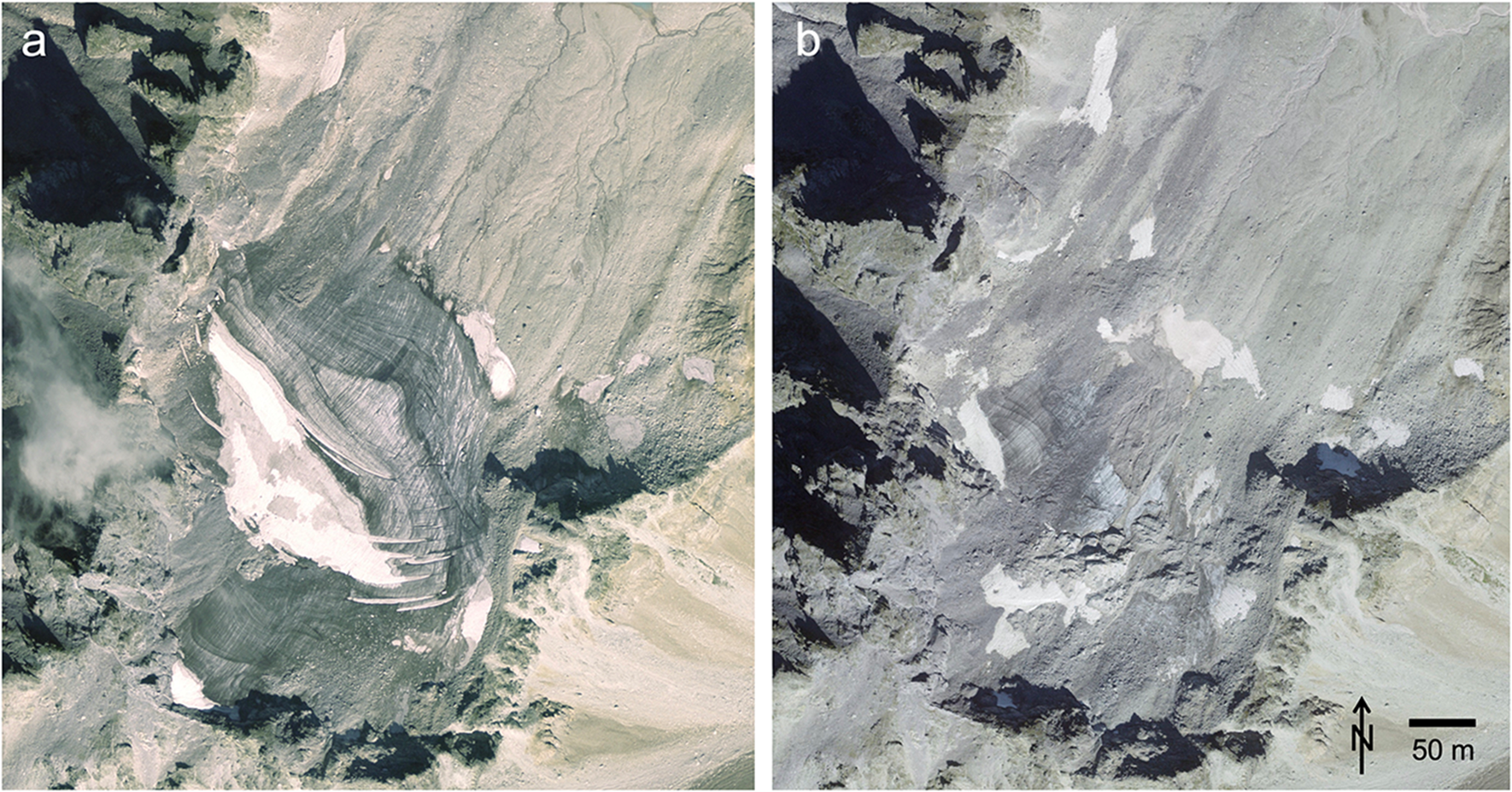
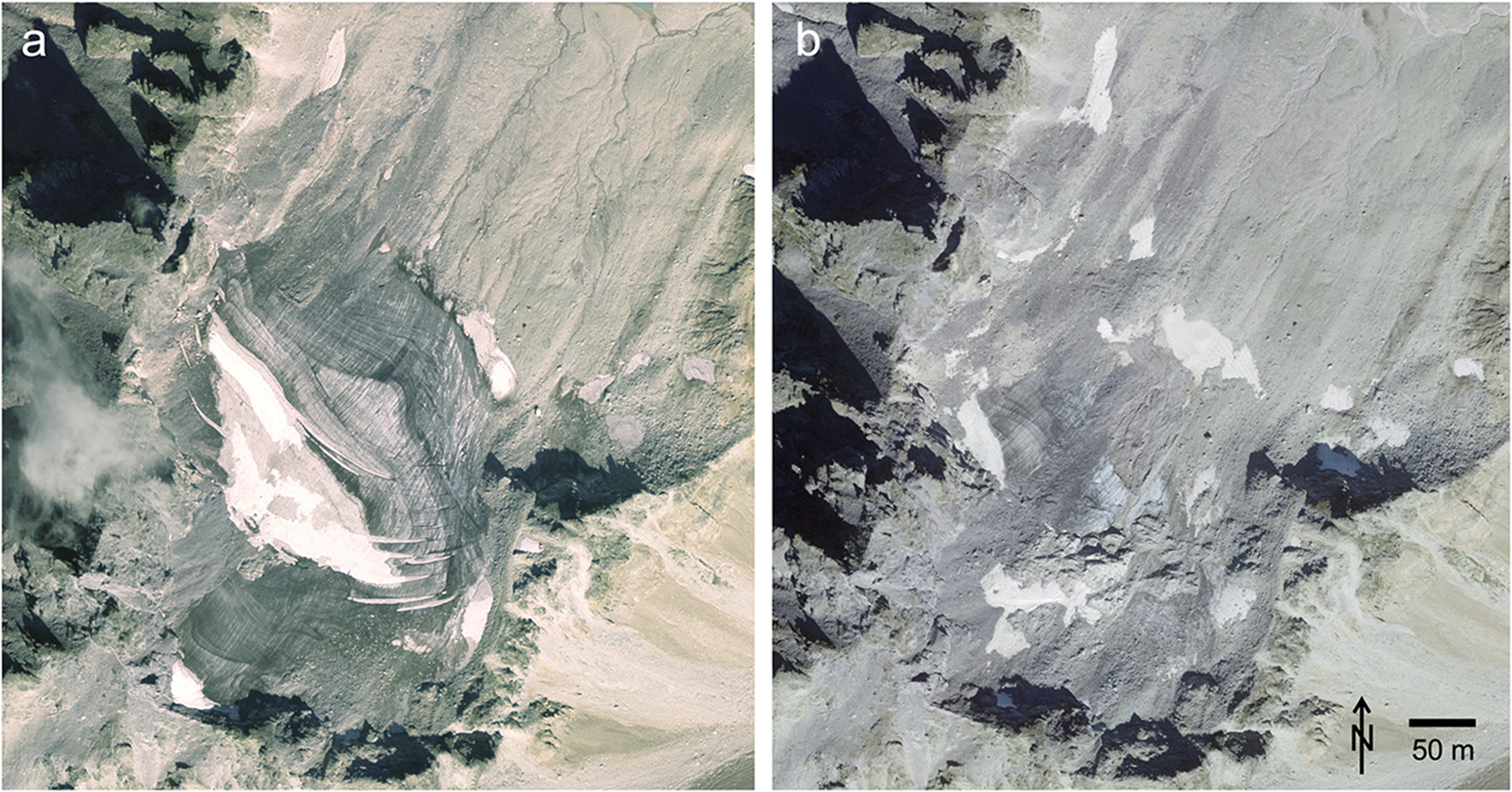
And what is the public perception of the term glacier? This is difficult to say without a dedicated survey, but it can be assumed that when the term ‘glacier’ (or a synonym in the respective language) is in the name of an ice body, that it is or was indeed a glacier. When such a glacier receives attention during its lifetime for a specific reason (see examples in Section 1) and is at some point no longer suitable for this, it might be declared dead or extinct although some ice is still there. For example, the glacier can be buried under debris and no longer visible (Section 3.5), it might be stagnant (no evidence of ice flow) and be reclassified as an ice patch (Section 3.4), it can be smaller than a given size threshold (Section 3.1), no longer suitable for summer skiing (Monty and others, Reference Monty, Flowers, Crompton, Menounos and Mathias2026) or too dangerous (e.g. due to increasing rock fall) to be measured. For example, the 2019 funeral of Pizol Glacier in Switzerland received high media attention although remnants of the glacier were still around (Fig. 1). As these remnants might still be mapped for a glacier inventory, the existence of a glacier becomes a matter of the application. A further important point is thus to describe the handling of glacier status changes when statistics on glacier number or area changes are calculated.
Pizol Glacier in Switzerland as seen from aerial photographs taken in (a) 2005 and (b) 2019, when the glacier was declared ‘dead’. Image source: maps.geo.admin.ch.
3. Challenges
3.1. Minimum size
Assuming that very small ice bodies might not flow and considering that the UNESCO guidelines for the creation of glacier inventories (UNESCO/IASH, 1970) used a maximum of two decimals for the entry ‘Total area in km2’, a minimum size of 0.01 km2 has been widely applied to distinguish glaciers from firn and snow patches, in particular when Landsat satellite images are used to map glacier extents (see Leigh and others, Reference Leigh, Stokes, Carr, Evans, Andreassen and Evans2019). At the 30 m resolution of Landsat, a glacier >0.01 km2 should consist of at least 12 connected pixels. For the 10 m Sentinel-2 sensor this threshold would be 100 pixels as the minimum size. One problem here is that perennial firn and snow patches could be much larger and glaciers could be smaller than this. Hence, despite its wide use, size might not be a good criterion to distinguish glaciers from snow patches and other ‘non-glacier’ ice bodies. Another point is that Sentinel-2 (or higher resolution sensors) can well identify much smaller ice bodies, e.g. down to 0.001 km2 for Sentinel-2. Hence, the question arises if glaciers smaller than 0.01 km2 have been mapped, should they be removed from a glacier inventory with a size threshold?
The answer to this question might depend not only on the purpose of the inventory, but also on snow conditions or the size of the glaciers in the region. When they are very small such as in the Pyrenees (Izagirre and others, Reference Izagirre2024) or the Kang Yatze Massif in Ladakh where they are also an important source of water (Schmidt and Nüsser, Reference Schmidt and Nüsser2012), it could be of interest to also include the smallest ice bodies, even when they are not classified as glaciers. In regions like Svalbard or Alaska, where many glaciers are much larger than 100 or even 1000 km2, glaciers smaller than 0.1 or 1 km2 might be considered as not relevant and thus not included in a single inventory (e.g. Nuth and others, Reference Nuth2013). However, if it is a second inventory and a purpose is change assessment (area change rates), glaciers smaller than this threshold should be kept to correctly consider all glacier parts that belonged to a former parent glacier. For example, a glacier that disintegrated into five smaller pieces of 0.08 km2 would have disappeared in an inventory with a size threshold of 0.1 km2 although the glacier only shrank by 20% from 0.5 to 0.4 km2. Moreover, analysts could remove the five pieces from the sample when they classify them as dead ice (i.e. no longer connected to an accumulation area).
Glaciologically correct calculations for change assessment should consider ignoring minimum size thresholds and including smaller ice bodies located within previous glacier extents. As different analysts usually work with different glacier definitions, the absence of a glacier in a later dataset does not necessarily mean that the glacier has disappeared, but only that it is no longer counted according to the rules applied. Hence, when several analysts are responsible of consecutive glacier inventories, special attention should be given to the temporal consistency of glacier identification. To consider a change of status for change assessment, it is important to either exclude the related glacier from the beginning or count and consider its parts also in the consecutive survey. Otherwise, any derived area change rates would be impacted by the smaller sample and thus cause a biased (too negative) result.
3.2. Dead ice
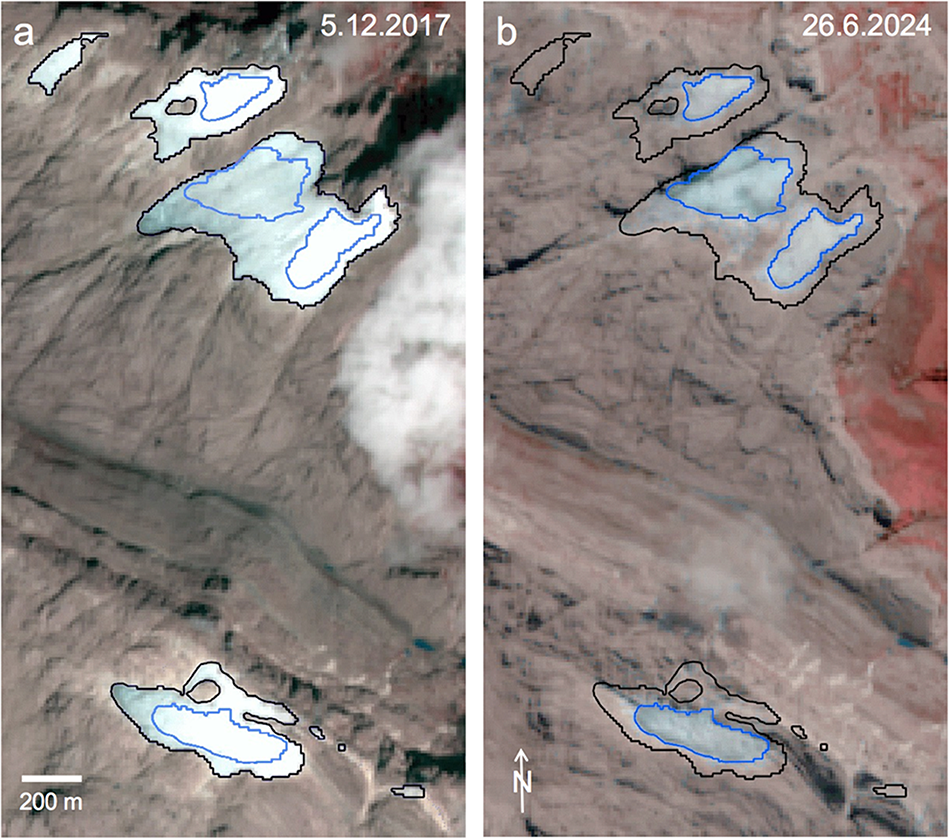
Although glacier parts being dynamically disconnected from a larger main glacier (i.e. dead ice) will no longer receive any mass from glacier flow, such ice bodies might still receive accumulation from snowfall and continue to exist for some time. On the other hand, glaciers which are now located below the snow line might no longer have an accumulation area and the ice mass is just melting down like a block of ice. Despite being dead ice, such ice bodies should be considered as glaciers due to their size and possible past flow. An example of such quickly disappearing dead ice bodies are the remaining glaciers of Papua (Indonesia) that melt down in place and shrunk from 0.51 km2 in 2017 to 0.18 km2 in 2024 as derived from Sentinel-2 satellite images (Fig. 2).
The rapidly shrinking glaciers of Papua (Indonesia). Sentinel-2 satellite images acquired on (a) 5/12/2017 and (b) on 26/6/2024 both with glacier outlines for 2017 in black and 2024 in blue. The upper three ice bodies represent the remnants of the East Northwall Firn and the lower one is Carstensz Glacier. Images: Copernicus Sentinel data 2017 and 2024.
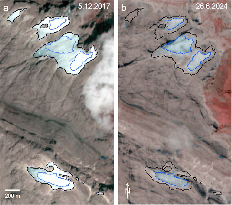
Thereby, the disintegration of the once much larger East Northwall Firn (that included the now disconnected northern pieces in one ice mass) into several fragments (e.g. Permana and others, Reference Permana2019) reveals another aspect of unrecognized glacier disappearance: As long as there is one remaining glacier piece with the same name and/or ID, the separated parts disappear silently. To be countable, the individual parts must have been separated by ice divides beforehand (see Section 3.3) to get their own ID. Otherwise, lost glaciers can only be counted from inventory two to three (e.g. Andreassen and others, Reference Andreassen, Nagy, Kjøllmoen and Leigh2022).
Also disconnected dead ice resulting from down-wasting of a glacier tongue after a surge has shown signs of ‘past flow’ and should thus be considered as a part of the glacier and included for its total area when area changes are calculated. However, as the handling of multi-part polygons (two or more separate polygons with a common ID) can be difficult in a database, all pieces belonging to a former glacier have to be individual (single-part) polygons. To perform the summing up of these polygons correctly and automatically, they have to get a common ID (from the parent glacier) in their attribute table. In any case, the important point is to properly describe in a related publication how such separated dead ice bodies have been handled in a glacier inventory and how glacier size for change assessment has been calculated.
3.3. Ice divides
Ice divides separate glaciers into independent units and usually also define hydrological watersheds, i.e. assign into which hydrological basin the melt water is flowing. As a simple approximation, ice divides are derived from the surface topography provided by a digital elevation model (DEM). From this DEM, a flow direction grid is calculated and watershed analysis provides the ice divides for each glacier (e.g. Kienholz and others, Reference Kienholz, Hock and Arendt2013). In many cases, a larger glacier is composed of several parts emerging from different basins that are usually separated in the ablation region by distinct medial moraines. Such multi or compound basin glaciers are considered as one unit in a glacier inventory, i.e. they are not separated by ice divides as they are dynamically connected. During glacier retreat, a former glacier tributary might separate from the main ice body and melt away. Similarly for ice caps and glacier complexes that are not separated by ice divides. Whereas the number of resulting glacier fragments can be counted, recognizing a glacier as disappeared requires that its ID is no longer present (see also Medrzycka and others, Reference Medrzycka, Copland and Noël2023). As a consequence, the real number of disappeared glaciers (here, hydrologically different units) will always be underestimated.
3.4. Perennial snow and firn
Perennial snow and firn is usually excluded from glacier inventories. However, in regions with a maritime climate these features can persist for decades and grow or shrink as glaciers do. They are often found in topographically protected places (e.g. north-facing slopes and shaded regions) and can survive due to occasional high snow fall. In many cases, a body of ice might be underneath the snow cover that only becomes visible in years of extreme melt. Accordingly, identification of the nature of these features from satellite or aerial imagery is difficult and they have been either excluded or included in glacier inventories. The gradual transition of perennial snow or firn to ice patches or glacierets makes the assignment even more difficult. The latter are described as very small glaciers of arbitrary shape with no visible surface flow (Cogley and others, Reference Cogley2011) and should thus be included in glacier inventories. However, as the naming of these features might also follow local rules, their names may be misleading, indicating a glacier although it is not, e.g. Glámujøkull in western Iceland (Sigurðsson and Williams, Reference Sigurðsson and Williams2008). The studies by Leigh and others (Reference Leigh, Stokes, Carr, Evans, Andreassen and Evans2019) and Andreassen and others (Reference Andreassen, Nagy, Kjøllmoen and Leigh2022) show further examples of small ice bodies and discuss the issues in properly identifying them.
Distinguishing these small ice bodies is of relevance when it comes to the climatological interpretation of their possible disappearance. Whereas perennial snow or firn patches can exist under special topographic conditions (Glazirin and others, Reference Glazirin, Kodama and Ohata2004) and can vanish and reappear at decadal timescales (they are thus not useful as climatic indicators), ice patches and glacierets might be thousands of years old with a related high relevance for (paleo-)climatic studies and archaeology (e.g. Haeberli and others, Reference Haeberli, Frauenfelder, Kääb and Wagner2004; Bohleber and others, Reference Bohleber, Schwikowski, Stocker-Waldhuber, Fang and Fischer2020; Pilø and others, Reference Pilø, Reitmaier, Fischer, Barrett and Nesje2023). It is thus important to know where they are located and how they have changed over time. Another problem arises when glaciers are reclassified as ice patches/glacierets and may no longer be a part of an inventory, although ice bodies are still present and should thus be included according to Cogley and others (Reference Cogley2011). At best, such ice bodies are included but get a separate code assigned (e.g. Zalazar and others, Reference Zalazar2020; Andreassen and others, Reference Andreassen, Nagy, Kjøllmoen and Leigh2022). Thus, it is important to detail whether a glacier has disappeared due to renaming, according to a size threshold or complete disappearance.
3.5. Debris cover
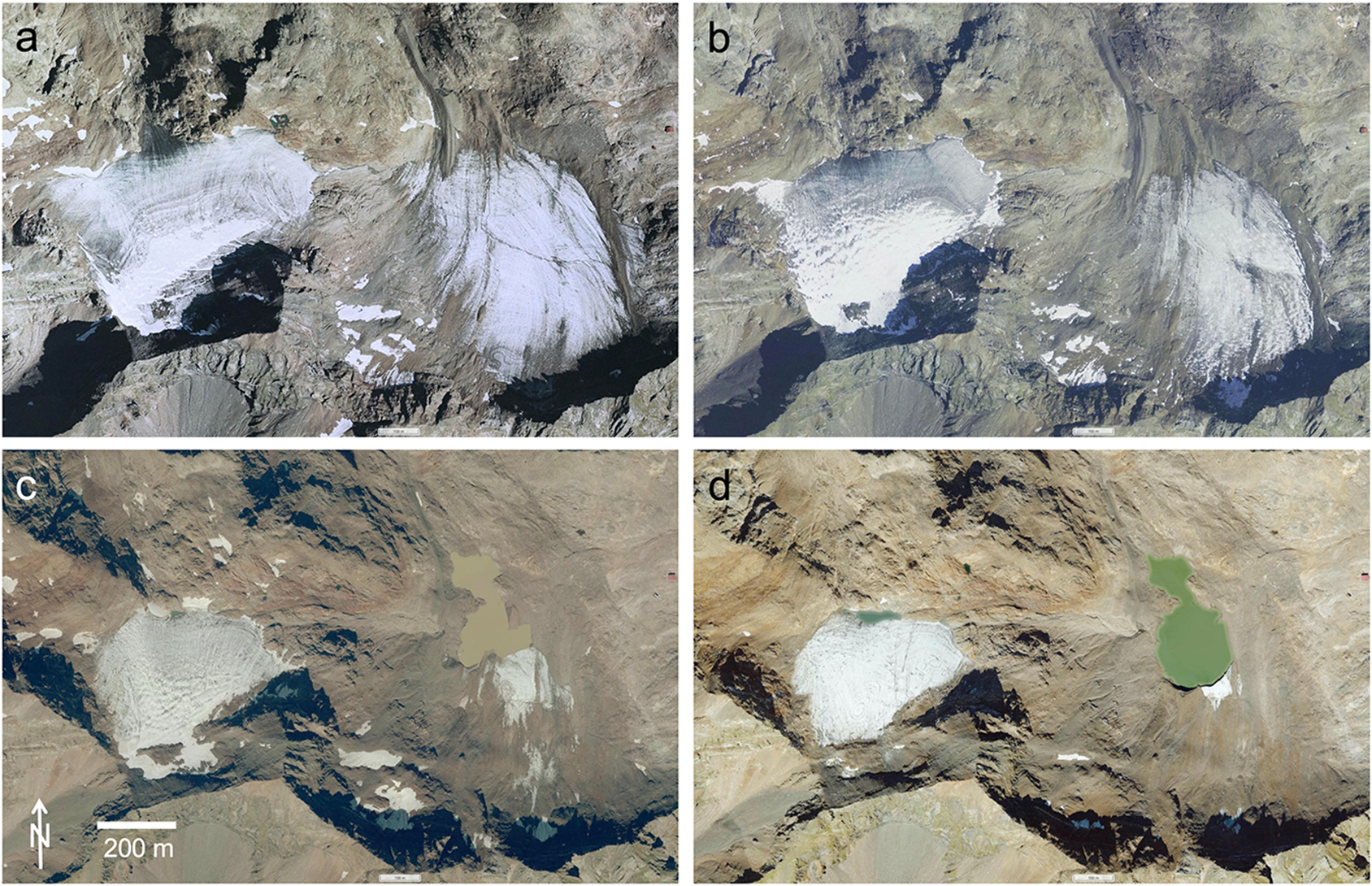
Small cirque glaciers might become increasingly sheltered below mountain walls as they retreat, experiencing reduced melt rates due to less exposure to solar radiation from increasing shadowing and a possibly thickening and/or more widespread debris layer (e.g. Carrivick and others, Reference Carrivick2015). As Fig. 3 shows, small glaciers can quickly get debris-covered by rock avalanches and become invisible, i.e. seem to have disappeared in the public view. However, the debris will keep the ice bodies in existence for some time before they ultimately disappear. As this is a gradual process, the exact timing of their disappearance is difficult to determine, even when analysing very high-resolution aerial photography (Fischer and others, Reference Fischer, Schwaizer, Seiser, Helfricht and Stocker-Waldhuber2021).
The rapid burial of small cirque glacier (Geltalferner, Italy) under debris cover. The images are from (a) 1999, (b) 2006, (c) 2020 and (d) 2023. Whereas area changes from 1999 to 2006 are small, the shrinkage from 2020 to 2023 is well visible. Image source: Screenshots from https://mapview.civis.bz.it.
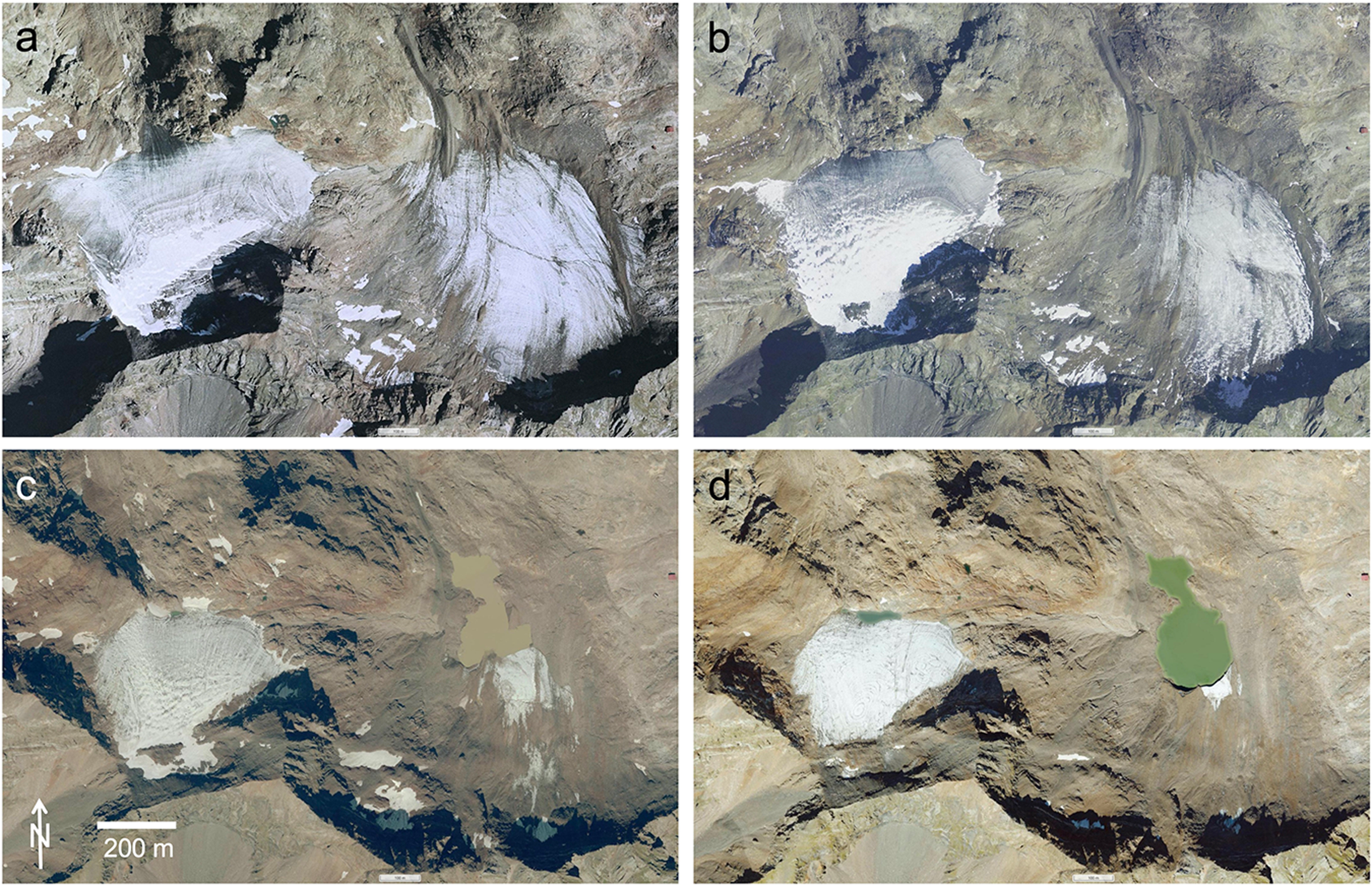
Figure 3 shows the temporal development (1999–2023) of two small cirque glaciers in Italy (Geltalferner). The glacier to the left is located a few hundred metres higher than the one to the right, and has some winter snow surviving in most years, thus shrinking more slowly. The lower-lying glacier is getting increasingly covered by debris (which may prolong its existence) and hard to recognize on the image from 2023 (3d). On this panel, one can see that its terminus is quite steep (casting a shadow) and calving into a proglacial lake.
Extended survival of very small glaciers due to increasing amounts of debris cover, topographic shading and accumulation from snow avalanches is a well-known process (Kuhn, Reference Kuhn1995) that has been investigated with a mass balance model by Huss and Fischer (Reference Huss and Fischer2016). Also, the well-shaded, avalanche fed and highly debris-covered Calderone glacieret in Italy is seemingly rather resistant to increasing temperatures and despite its southern latitude (42.5° N) it is still more than 30 m thick (Dossi and others, Reference Dossi2024). However, it is named now a glacieret and has been removed from the inventory (although glacierets should be included). As this is a rather academic decision, the public might still see it as an existing glacier, in this case maybe also due to its special southern location and thus more iconic perception.
3.6. Glacier monitoring
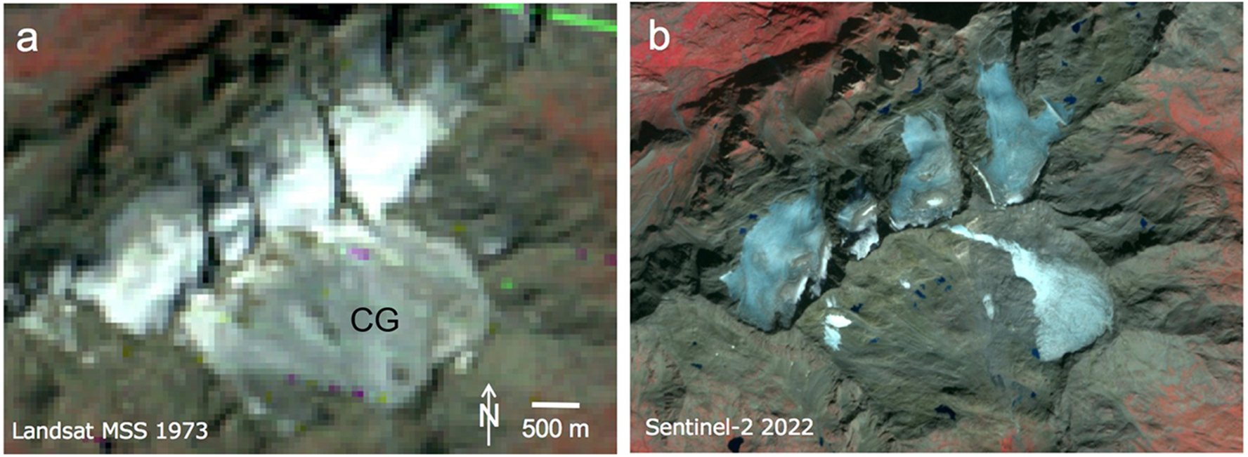
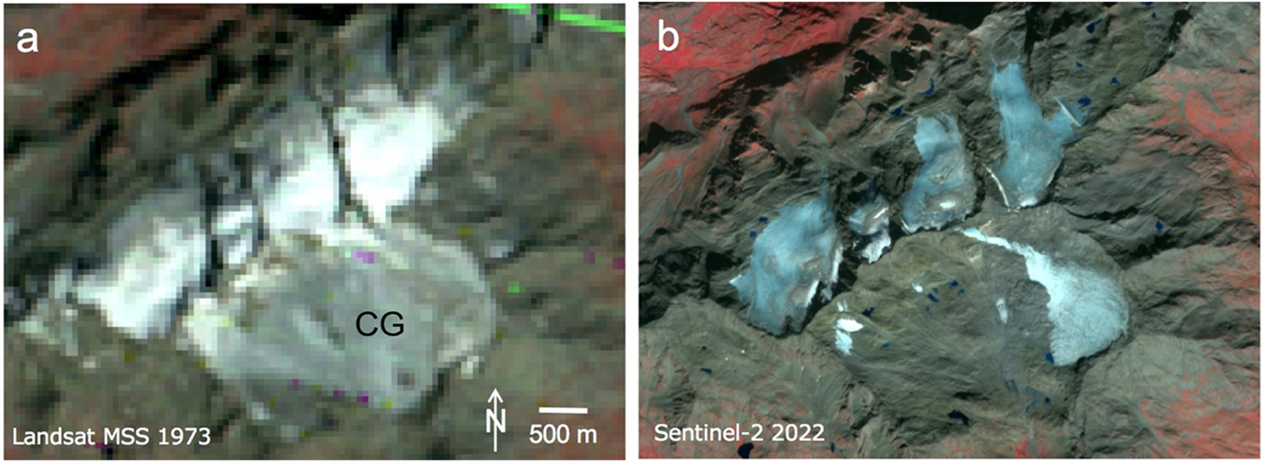
Shrinking or disintegrating and finally vanishing glaciers also impact glacier monitoring, in particular mass balance measurements. These can become more and more difficult in the field (Section 2) and the obtained values less representative or even biased, making their climatological interpretation difficult. Usually, measurements of ablation and accumulation are continued on decaying glaciers, even if they disintegrate into pieces that are technically dead ice (e.g. Carturan and others, Reference Carturan2013; Thibert and others, Reference Thibert, Eckert and Vincent2013). Whereas such measurements are helpful to understand the glacier–climate relationship (Huss and Fischer, Reference Huss and Fischer2016), non-climatic controls such as the additional heating by growing rock outcrops (Aubry-Wake and others, Reference Aubry-Wake, Zéphir, Baraer, McKenzie and Mark2017) cause more negative mass balances for such glaciers than for ‘active’ glaciers. This causes a negative bias in mass balance values when averaged over a larger region such as the Alps (e.g. Carturan and others, Reference Carturan, Rastner and Paul2020). At best, replacement glaciers with a longer existence have been identified in time to perform parallel measurements. For the rapidly shrinking Careser Glacier in Italy (Fig. 4) that has mass balance measurements since 1967 (Carturan and others, Reference Carturan2013), such a replacement has been established with the nearby La Mare Glacier (Carturan, Reference Carturan2016).
Disintegration of Caresèr Glacier (‘CG’) in the Italian Alps from (a) 1973 to (b) 2018. Image credits: (a) earthexplorer.usgs.gov, (b) Copernicus Sentinel data 2018.
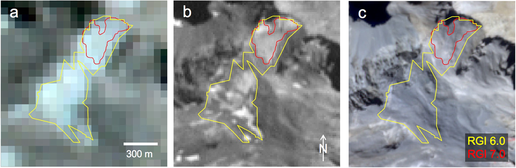
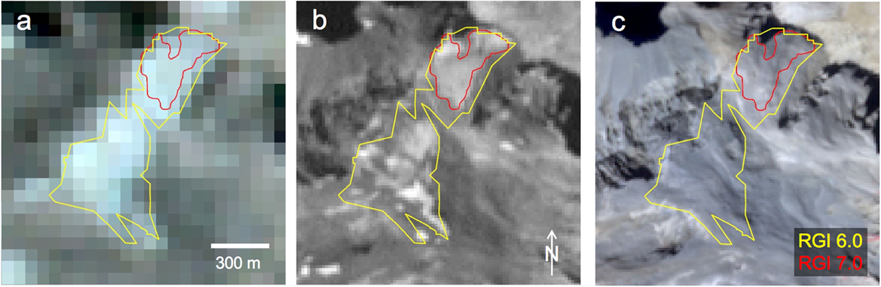
However, the loss of a long-term mass balance time-series due to glacier decay has further negative impacts, in particular when over a large region only one or a few glaciers are measured. For example, the now almost disappeared Echaurren Norte Glacier in Chile (Fig. 5) has a mass balance time series dating back to 1975 (Farías-Barahona and others, Reference Farinotti, Round, Huss, Compagno and Zekollari2019) and was a key glacier to estimate annual mass balances for the central Andes and before the year 2000 even for the Southern Andes (Patagonia) and Subantarctic Islands (Dussaillant and others, Reference Dussaillant2024). Without this glacier, the calculation of annual mass balance fluctuations over this region would have been nearly impossible and related estimates of their contribution to sea-level rise would have been more uncertain (GlaMBIE Team, 2025).
The vanishing of glacier Echaurren Norte in Chile as seen with freely available satellite images from (a) Landsat MSS in 1976, (b) Landsat ETM+ (pan band) in 2000 and (c) Sentinel-2 MSI in 2023. Outlines from RGI 6.0 (yellow) and 7.0 (red) are shown for reference. In 2023, the glacier has basically disappeared, but there might still be some ice underneath the debris. Image credits: (a) and (b) earthexplorer.usgs.gov, (c) Copernicus Sentinel data 2023.
The decision to end such a long-term time-series before a glacier has completely disappeared is thus challenging. Whereas thousands of glaciers disappear without being reported, the loss of certain individual glaciers may be especially impactful, in particular if they are part of a long-term monitoring program.
4. Recommendations
The statement that a glacier has disappeared does not necessarily mean that no ice is left. Assuming that the ice body was indeed a glacier before, its disappearance can mean that it is now smaller than a given size threshold (e.g. <0.01 km2), reclassified as a glacieret or an ice patch, no longer visible or recognizable on the satellite image used or on the ground (e.g. covered by rocks and debris), disintegrated into many smaller pieces that do not flow or being smaller than a given size threshold, or no longer possible to be measured (e.g. because it has become too dangerous). Or, as Pope (Reference Pope2025) summarizes it: ‘Classification can be a useful tool, but at times it can also be somewhat subjective or arbitrary.’ Indeed, the public perception might be less complex, e.g. ‘a glacier has disappeared when it is no longer visible.’ This is certainly also valid, but as most glaciers disappear far away from human settlements, some quantitative criteria have to be applied to count them.
As the differences in the criteria applied create uncertainty for any reported number of disappeared glaciers, it is recommended to also report the criteria that have been applied to decide why a glacier is no longer counted. As a suggestion, the reasons (R) could be:
• R0: no ice is left,
• R1: ice might still be there, but it is invisible (e.g. covered by debris or snow/firn),
• R2: ice is still present, but it is no longer counted as a glacier by definition (e.g. < 0.01 km2, dead ice, ice patch),
• R3: the glacier is no longer suitable for measurements (e.g. disintegrated, rock fall) and thus removed from a sample,
• R4: other reasons (to be named).
Such a coded list could lead to proper registration and thus counting of the vanished glaciers. When this number is part of a scientific work, e.g. change assessment from two glacier inventories, all glacier fragments should be considered for the calculation of glacier area at the later point in time (even if <0.01 km2 or no longer named a glacier). Otherwise (assuming shrinking glaciers) an overestimation of area loss rates would result. Due to glacier fragmentation, the number of glaciers in a region can increase over time despite many glaciers being lost. To automatically count the fragments and their total area in a second inventory per former glacier, it is recommended to assign in the attribute table of the more recent dataset a parent glacier ID to all pieces that were once part of the larger glacier. The number of disappeared glaciers can only be counted when the related IDs have disappeared, i.e. the glacier must have its own ID in the previous inventory.
The total number of glaciers and how many have disappeared is perhaps not important for scientific research; however, this is of interest to the general public and a clear message to inform about the melting cryosphere. It is thus important to have guidelines on how to register the disappearance of glaciers as explained above. Due to the interpretation differences described above, concluding about the number of disappeared glaciers by comparing two glacier inventories created by different analysts will likely result in a wrong number. However, whenever the same analysts create a second inventory of the same region, the number of disappeared glaciers should be determined and reported. Even more important is the correct consideration of the mentioned recommendations for change assessment, e.g. that the sample is not changed due to a change of glacier status and that all fragments of a former glacier are counted even when smaller than a given threshold size. When the disappearance of an individual glacier is reported in the media, many glaciers have disappeared over the same period without reporting. For a wider perspective, it might be worth mentioning this as well.
Acknowledgements
This study has been performed in the framework of the ESA project Glaciers_cci+ (4000127593/19/I-NB). I would like to thank the two reviewers, the Scientific Editor H Hannesdóttir and the Associate Chief Editor LM Andreassen for their thoughtful reviews and constructive comments that helped to improve the clarity of the paper.

 Open access

