


Introduction
In an era where technology is so profoundly integrated with daily life, understanding its impact on our behavior, as well as both personal and communal outcomes, has never been more critical. Americans spend roughly a third of their waking life on digital platforms (Wakefield, Reference Wakefield2022); and with the global app market valued at 200 billion dollars, projected to triple by 2030, ‘big tech’ companies have a strong incentive to prioritize short-term user satisfaction, over well-being, in app design (Harris, Reference Harris2023). This raises a crucial question: should apps like Google Maps, in their function, strive to reconcile immediate gratification with long-term health and social well-being?
Physical activity is shaped by daily choices, often under the influence of technology (Liu et al., Reference Liu, Zhang and Xu2023). It is vital for maintaining both physical and mental health; and it supports healthy body weight, increased mobility, and reduced risk of chronic diseases (Penedo and Dahn, Reference Penedo and Dahn2005; U.S. Department of Health and Human Services, 2008; Smith et al., Reference Smith2013; Steinmo et al., Reference Steinmo, Hagger-Johnson and Shahab2014; Alzahrani et al., Reference Alzahrani2019). Yet, 80% of Americans fall short of physical activity goals. Moreover, given that half are living with chronic disease, and greater than 70% are overweight, increasing physical activity is a pressing need (Fryar et al., Reference Fryar, Carroll and Afful2020). Walking emerges as a practical and low-cost way for many to reach these goals; still, just half of American adults’ report walking during their leisure time and less than a third for transportation (U.S. Department of Health and Human Services, 2008; Paul et al., Reference Paul2015). Therefore, daily transportation decisions, especially those shaped by digital navigation tools like Google Maps, become critical in this context.
Beyond individual health concerns, broader implications of public health and societal sustainability are also paramount to this discussion. Despite rapid urbanization and increasing environmental awareness, greener transportation choices remain vastly underutilized in the USA (United Nations, 2019). Americans still favor driving for short distances; and the transportation sector is now the largest contributor to greenhouse emissions in the USA—with 59% of this total coming from passenger cars (Small, Reference Small2019; Buehler and Pucher, Reference Buehler and Pucher2023). Furthermore, a study of 11 mid-western metro areas found that replacing half of short car trips with non-motorized transport could decrease annual deaths by 1,295, as well as reduce emergency department visits for heart and lung issues, attributable to pollution-related effects, by about 95,000—resulting in $8.7 billion in annual healthcare savings (Grabow et al., Reference Grabow2012). Thus, shifting even a fraction of short car trips to walking could markedly reduce health-related deaths, save billions in healthcare costs, and have a profound positive impact on the environment.
The adoption of new transportation habits, however, necessitates significant behavioral change (Piras et al., Reference Piras, Sottile and Meloni2018). Constrained by high costs, limited reach, and the need for continuous capital investment, traditional government initiatives, aimed specifically at promoting transportation-related walking, have had marginal success—underscoring the need for alternative and complementary strategies (Kumar et al., Reference Kumar2018). Perhaps behaviorally influenced interventions, built into digital apps and designed to engage Americans at the point of decision-making, can help reduce car dependency. Numerous studies have shown some positive effect when evaluating the use of digital apps and behavioral interventions to increase walking and physically active transportation (Froehlich et al., Reference Froehlich2009; Wunsch et al., Reference Wunsch2015; Harries et al., Reference Harries2016; Bliss, Reference Bliss2018; Wernbacher et al., Reference Wernbacher2020). However, these custom apps or programs, often designed specifically for studies, are substantially limited in their reach and usefulness to the general population. Moreover, they are often intended to benefit users who are actively looking to increase their physical activity. With 77% of smartphone owners regularly using navigation apps, and Google Maps being the most popular by a wide margin, there is a significant opportunity to interface with most Americans (Panko, Reference Panko2018; Bensinger, Reference Bensinger2020)—particularly the general population and those not consciously thinking about their activity levels.
Google Maps displays navigation directions based on either a user-defined default mode of transportation (selection of which is buried deep in the app’s settings) or, most often, based on prior user behavior and the last mode of transportation used. An individual who always drives, therefore, would not be shown walking directions (by default), even for short trips, unless they manually ‘opted-out’ of seeing driving directions. In such scenarios, showing walking directions by default might be preferable and potentially alter transportation choice. Nudges modify decision architecture, while preserving choice, and aim to influence behavior toward decisions that promote individual welfare; ideally, they also benefit society (Thaler and Sunstein, Reference Thaler and Sunstein2008). This work explores Google Maps’ capacity to utilize nudges, by modifying default displayed transportation directions, to increase walking behavior for transportation, and with the goal of aligning immediate consumer needs with long-term personal well-being and social goals.
Experimental design and methods
Institutional review board approval was obtained under the protocol guidelines of Harvard Law School. A survey was designed in which participants were randomized and exposed to 1 of 4 representations of Google Maps directions: A to B with walking directions displayed as the default (Figure 1A), driving directions displayed as the default (Figure 1B), walking directions as the default plus a graphic prompt (Figure 1C), or driving directions as the default plus a graphic prompt (Figure 1D). The map directions illustrated a 0.8-mile route from an urban neighborhood location ‘A’ to a nearby high street destination ‘B.’ It was estimated by the app that the route would take 14 minutes to walk and 6 minutes to drive. The Walk Score® of the neighborhood depicted was 93. Walk Score® is a validated measure that rates the walkability of any address based on the distance to amenities like stores, parks, schools, and public transit, indicating how easy it is to accomplish daily errands on foot (Duncan et al., Reference Duncan2011; Cole et al., Reference Cole2015). The prompt was designed to function as a social norm and signal social expectation; it also illustrated the average calories burned should the respondent choose to walk the route displayed, as well as associated text stating ‘Most Choose to Walk.’
Directions from A to B, as would be depicted on a typical smartphone by Google Maps (Map data ©2019 Google): walking directions presented as default (Figure 1A), driving directions as default (Figure1B), walking directions as default plus a graphic prompt (Figure 1C), or driving directions as default plus a graphic prompt (Figure 1D).
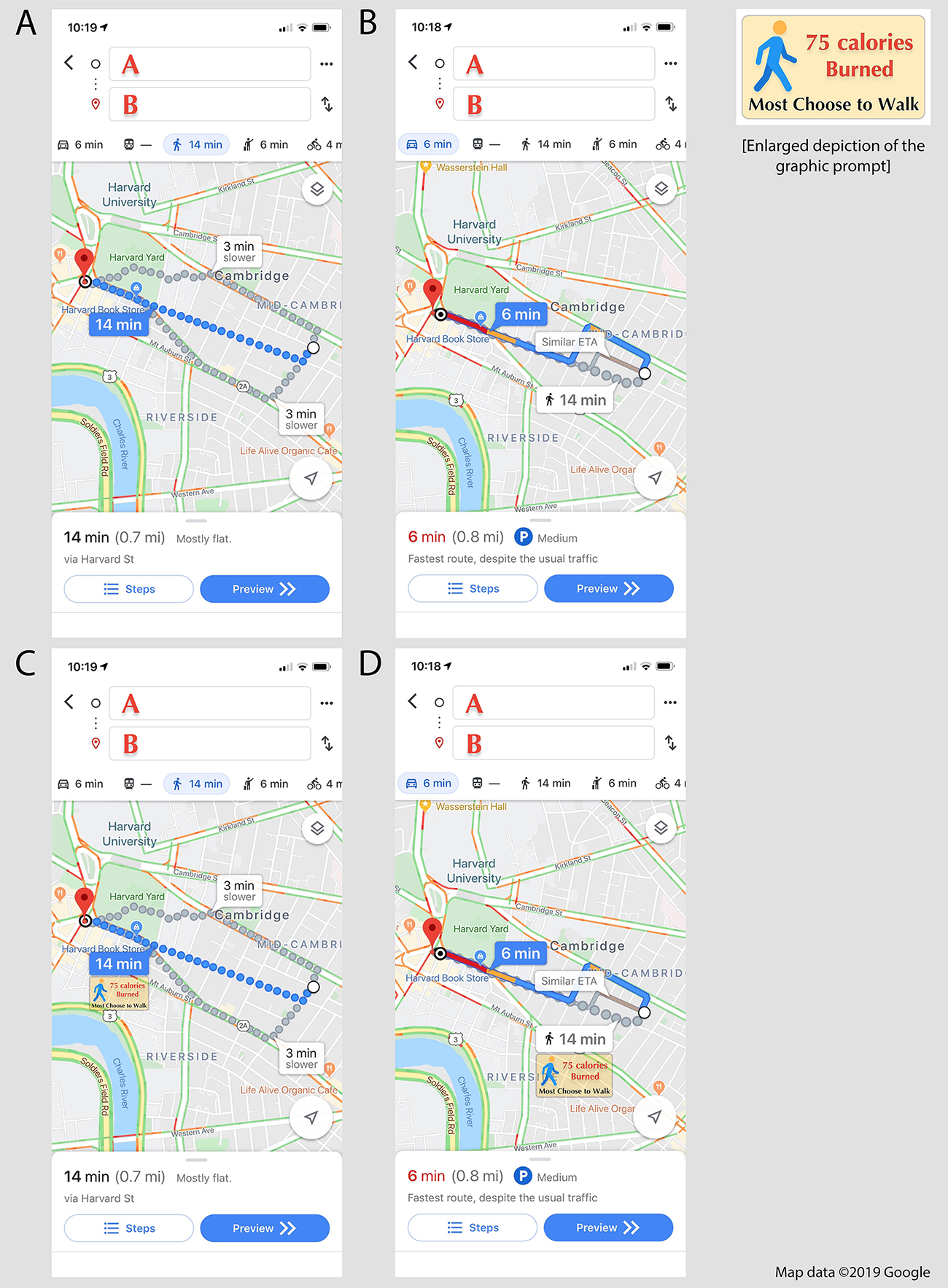
Respondents were asked: ‘Suppose you lookup directions from A to B on your maps app. Given the route suggested (and assuming that all options are available to you), how would you choose to get to your destination?’ The map directions depicted were derived and modified from what would be displayed on a typical smartphone app; specifically, Google Maps data was utilized (Map data ©2019 Google). Respondents were given the choice to answer ‘Walk, Drive (or Uber/Lyft), Bike, or Public Transport.’
Participants in this study were members of the general population in the US, randomly located throughout the country, and were recruited from Amazon’s Mechanical Turk (Mturk) (Seattle, WA, USA). The survey was hosted on Qualtrics (Qualtrics, Seattle, WA, USA). Mturk is a crowdsourcing platform that enables ‘workers’ to anonymously complete tasks (e.g. surveys) for monetary compensation, and it generates efficient and reliable results for research (Mortensen and Hughes, Reference Mortensen and Hughes2018). Recruitment in this study was restricted to those geographically residing in the US; there were no other exclusion criteria. Specifically, study participants were randomized to 1 of 4 map exposure groups. Sample size and randomization was managed by the Qualtrics ‘randomizer’ function, which balances randomization and evenly distributes exposure groups. Survey respondents were also asked a series of demographic questions for study group comparison. All questions were mandatory. In addition, ‘attention check’ questions, which assessed content awareness, were utilized to identify and remove spurious clickers. Results from respondents who failed the ‘attention checks’ were discarded. Fisher’s exact test was utilized to analyze the categorical data. Statistical analysis was performed using STATA by StataCorp LLC (College Station, TX, USA) and Prism by GraphPad Software (San Diego, CA, USA).
Results
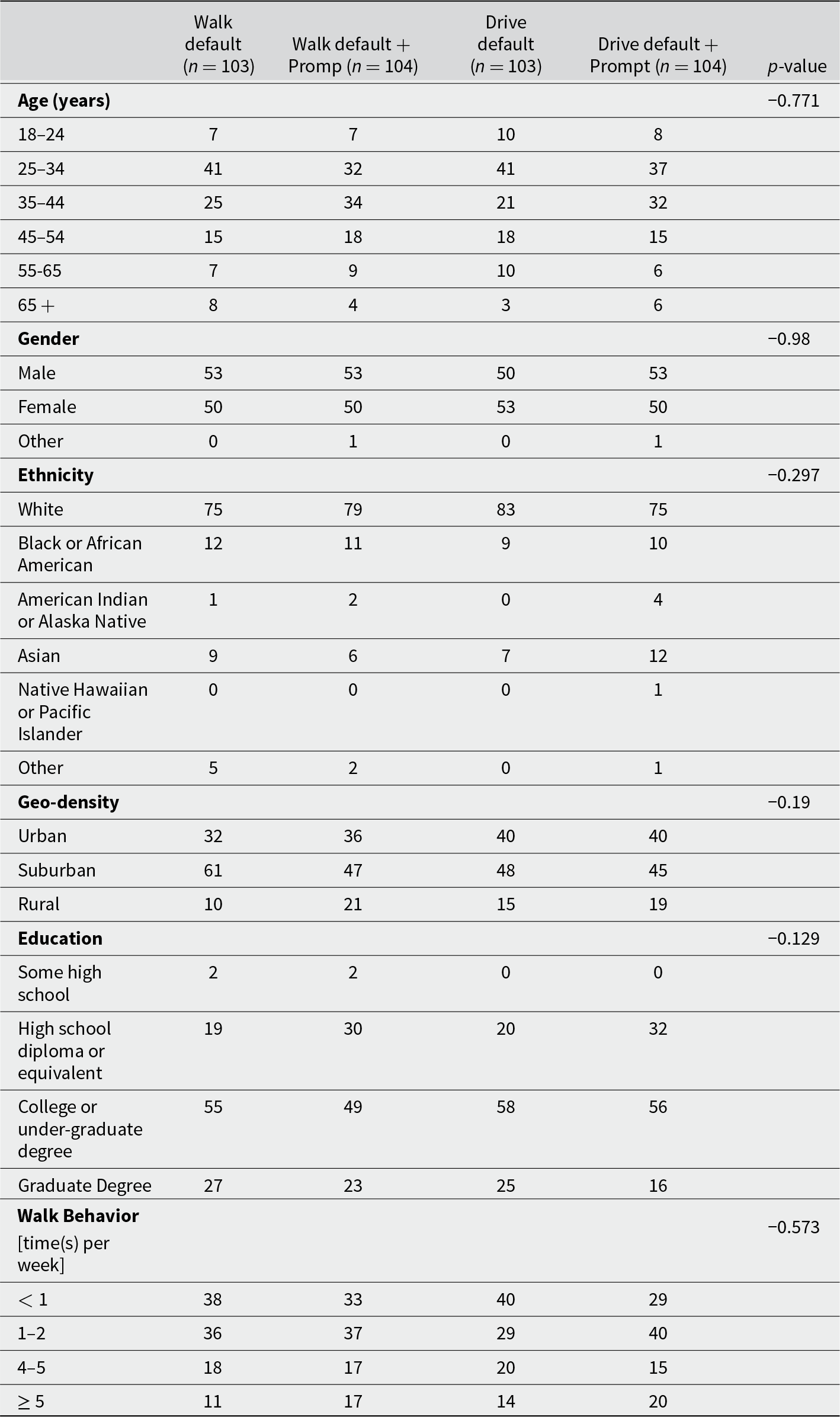
Demographic distribution: The demographic distribution was similar between the four map exposure groups, and there were no statistically significant differences—Age, Gender, Ethnicity, Geo-density, Education, and Walk Behavior (p = 0.771, p = 0.980, p = 0.297, p = 0.190, p = 0.129 and p = 0.573, Fisher exact). The average participant was white, college educated, and between the ages of 25 and 44 years; consistent with prior research studies utilizing Mturk (Hitlin, Reference Hilton2016). In addition, participants mainly resided in urban (35.7%) and sub-urban (48.6%) areas, and there was a near-even gender distribution between males (50.5%) and females (49.0%). Moreover, the average participant reported walking ≤ 2 times per week (68.1%). The total number of respondents (n) was 451, with 37 (8.2%) results discarded due to failed ‘attention checks’, a percentage consistent with known Mturk rejection rates (Barends and de Vries, Reference Barends and de Vries2019). Therefore, 414 completed surveys were accepted for final analysis, and the distribution of participants between the 4 study groups were well matched (n varied from 103 to 104 between groups) (Table 1).
Demographic data
Comparing transportation choice by map exposure group: All four map exposure groups were significantly different from one-another when compared as four independent groups (p = 0.016, Fisher exact) (Figure 2A) (Table 2). When comparing two groups at a time, walking directions displayed as default (Walk Default) versus walking directions plus the graphic prompt (Walk Default + Prompt) was significantly different (p = 0.042), Walk Default versus driving directions displayed as default (Drive Default) was not significantly different (p = 0.500), Walk Default versus driving directions plus the graphic prompt (Drive Default + Prompt) was significantly different (p = 0.024), Walk Default + Prompt versus Drive Default was significantly different (p = 0.029), Walk Default + Prompt versus Drive Default + Prompt was significantly different (p = 0.034), and Drive Default versus Drive Default + Prompt was not significantly different (p = 0.468).
Transportation choice displayed by map exposure group (Figure 2A), as well as sub-analyzed and displayed by reported walking behavior (Figure 2B).

Transportation choice by map exposure group
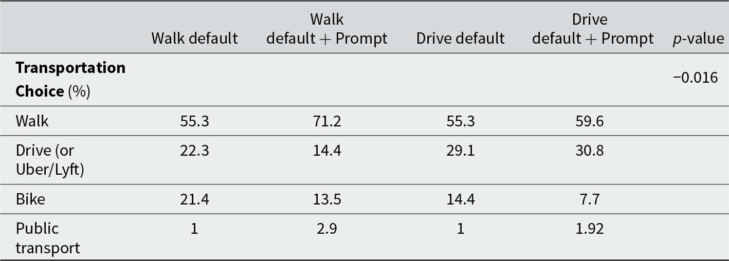
Analyzing percentage and relative change in walk choice by default map exposure group: Though the hypothetical choice to drive was lower in the walk default group (22.3% vs 29.1%), there was no statistically significant difference between the two default groups (in the absence of the prompt). Therefore, more detailed analysis was focused on comparing Walk Default + Prompt versus Drive Default and Drive Default + Prompt. Participants exposed to Walk Default + Prompt reported they would walk 71.2% of the time (drive 14.4%)—versus walk 55.3% of the time (drive 29.1%) for Drive Default and walk 59.6% of the time (drive 30.8%) for Drive Default + Prompt.
Reporting relative risk estimates, setting aside bike and public transport data, those exposed to Walk Default + Prompt were 1.27 times more likely to report they would walk (as opposed to drive) than those exposed to Drive Default (p = 0.009, 95% CI [1.07, 1.54], Fisher exact) and 1.27 times more likely to report they would walk (as opposed to drive) than those exposed to Drive Default + Prompt (p = 0.011, 95% CI[1.07, 1.52]).
Sub-analysis of walk choice by self-reported weekly walk rates: When sub-analyzing the groups based on reported levels of walking behavior: Walk Default + Prompt, among those who reported walking ≤ 2 time(s) per week, was significantly different from Walk Default (p = 0.008, Fisher exact), Drive Default (p = 0.046), and Drive Default + Prompt (p = 0.011). There was no significant difference between Walk Default + Prompt, among those who reported walking ≥ 3 time(s) per week, compared to Walk Default (p = 0.728), Drive Default (p = 0.606), or Drive Default + Prompt (p = 0.857) (Figure 2B).
Reporting relative risk estimates, those exposed to Walk Default + Prompt, and who reported walking ≤ 2 time(s) per week, were 1.27 times more likely to report they would walk (as opposed to drive) than those exposed to Walk Default (p = 0.035, 95% CI [1.03, 1.61], Fisher exact), 1.33 times more likely to report they would walk (as opposed to drive) than those exposed to Drive Default (p = 0.014, 95% CI [1.07, 1.70]), and 1.42 times more likely to report they would walk (as opposed to drive) than those exposed to Drive Default + Prompt (p = 0.003, 95% CI [1.13, 1.83]).
Discussion
When presenting alternative versions of the same route on Google Maps, I found that survey participants chose different modes of transportation at significantly different rates. Exposure to the Walk Default + Prompt map led to a 11.6–15.9% increase in the hypothetical choice to walk and a 14.7–16.4% decrease in choosing to drive, as compared to either map with default driving directions. In other words, participants exposed to this map were 1.27 times more likely to report they would walk.
The observed influence of default walking maps in this study underscores the critical role defaults play in guiding the decision-making process. Defaults often reveal significant inertia, in that individuals tend not to deviate from them (Madrian and Shea, Reference Madrian and Shea2000). For example, in 2000 the Swedish government encouraged pension plan participation by enacting a default enrollment ‘opt-in’, which has demonstrated remarkable durability nearly 20 years after the fact (Cronqvist et al., Reference Cronqvist, Thaler and Yu2018). Such ‘set-it and forget-it’ interventions may have an inherent design advantage over nudges that interact with decision-makers on a more regular and direct basis, as there is less opportunity for exposure fatigue or annoyance. Nonetheless, ‘softer’ nudges, like defaults, which require minimal conscious engagement, as opposed to direct ‘pokes’, like notifications and advertising campaigns, may be useful in modifying transportation behavior. A Canadian study, for instance, demonstrated one-third decreased elevator use in university buildings and, alternatively, increased use of the stairs, by subtly increasing the default time it took for elevator doors to close (Houten et al., Reference Houten, Nau and Merrigan1981; Hollands et al., Reference Hollands2013). The study found no such change in elevator use by deploying direct educational signs alone.
Other behavioral interventions designed to increase walking, and additional forms of ‘green’ transportation, have also noted meaningful effects on transportation choice. To cut back on emissions and reduce traffic congestion, Durham, N.C. tested whether a low-cost nudge could get commuters to choose alternative forms of transportation (Bliss, Reference Bliss2018). The city partnered with local employers to email personalized route maps (from an individuals’ home to their work address) that displayed bike, bus, and walking options compared to driving. The messages also included trip time comparisons and listed the potential health benefits of choosing the alternatives. The city reported an initial 12% reduction in single occupancy commuting choice among those who received the emails compared to those who did not. The program is now expanding to a wider audience, though assessing its penetration across a diverse population and the durability of its reported effects will be essential.
Likewise, innovative behavioral approaches to encourage walking have also been explored globally, including smartphone-based gamification strategies. An Austrian group developed an interactive smart phone app which it advertised to residents living in Graz. The app gamified pedestrian traffic by motivating ‘players’ through daily notifications to discover beautiful places and hidden corners of the city. The app rewarded participants for walking with in-app tokens, totals of which could be compared against other ‘players’ in the area. They noted increased walking behavior for short distances during the study period, as well as strengthened attitudes toward climate-friendly transportation and walking as a healthy choice (Wernbacher et al., Reference Wernbacher2020). Similar studies have also demonstrated some success with prompting small cohorts of volunteers to walk or bike for transportation with daily smartphone notifications (Froehlich et al., Reference Froehlich2009; Wunsch et al., Reference Wunsch2015). Beyond the unknown durability of such interventions, however, both voluntary participation and the use of uncommon apps severely restricts the applicability of their stated results to the general population, particularly among those who are not already physically active or walking for transportation—or at least interested in such.
Notably, when sub-analyzing the present study data based on self-reported walking behavior, those who reported walking ≤ 2 times per week (68.1% of the study population) were most influenced by the default walking maps. Exposure to the Walk Default + Prompt map among this group led to a 17.8% increase in choosing to walk or a 17.6–23.4% decrease in choosing to drive when compared to either default driving map. Participants exposed to this map were 1.27-1.42 times more likely to report they would walk. Unlike the broader study population, among those who reported walking ≤ 2 times per week, there was also a substantial reduction in the choice to drive among those exposed to Walk Default alone (without the prompt) versus Drive Default. Conversely, the choices of those who reported walking ≥ 3 times per week were not significantly affected by the map they were shown; in fact, such individuals, irrespective of map exposure, selected walk versus drive at a 3:1 or 4:1 ratio. This result makes intuitive sense, as there is limited scope to influence those who would already choose the intended outcome.
There was also a significant difference in the hypothetical choices made between the Walk Default and Walk Default + Prompt groups, suggesting that the prompt itself significantly contributed to the observed results. Given the prompt suggested the number of calories that would be burned with walking, perhaps those who do not normally walk were made to feel guilty about their decreased activity levels—and thus said they would choose to walk. To help minimize framing bias or the possible effect of guilt, I intentionally asked respondents about their walking behavior after obtaining their transportation choice. I did not want individuals to make their choice having just been reminded about their activity levels. In addition, the prompt included the text ‘most choose to walk’. Individuals constantly engage in social comparison and are highly influenced by the behavior of others (Bearden and Etzel, Reference Bearden and Etzel1982). A study in the UK found that primary care providers could be effectively persuaded to prescribe fewer antibiotics by simply being informed of their prescribing behavior compared to that of their peers (Hallsworth et al., Reference Hallsworth2016). Therefore, the descriptive norm displayed in the prompt may have reframed the context of the map for some and influenced their transportation choice by calling attention to a social expectation—i.e. that given the reasonably short route depicted, and considering it would be good for them, they should probably choose to walk.
Graphic prompts, such as the one used in the current study, could also vary in design, potentially yielding different effects. For example, other than calories burned and ‘most choose to walk’, a prompt could instead illustrate potential fuel savings, or the number of steps or progress a user would gain toward their daily activity goal. A 2020 study found that taking 8,000 steps per day, as opposed to 4,000, was associated with a 50% lower risk of death from cardiovascular disease or cancer; the median age of participants was 56.8 years (Saint-Maurice et al., Reference Saint-Maurice2020). For reference, a 1-mile walk would be approximately 2,500 steps. Notably, no link was observed between mortality and the intensity of steps (steps per minute); thus, a brisk walking pace was not required to receive the health benefit. Intriguingly, a more recent comprehensive meta-analysis found a reduction in death from cardiovascular disease with as few as 2,300 daily steps, with each additional 500 steps tied to a further 7% decrease in risk (Banach et al., Reference Banach2023). It is, therefore, no wonder that ‘smart’ tracking devices (e.g. the Apple Watch or Fitbit) have gained significant popularity. Given that 1 in 5 Americans now use health trackers to achieve daily activity goals, there is significant potential for integration of device-driven prompts within maps app functionality (McCarthy, Reference McCarthy2019).
Beyond health, harnessing behavioral interventions to promote walking could also have broader implications. As the USA continues to urbanize, with 82% of the population now living in urban areas, the practicality of walking as a transportation choice is increasingly evident (United Nations, 2019). However, despite greater density and proximity to destinations, an en masse change in our living circumstances has not been met with a corresponding change in our transportation behaviors. Seventy-five percent of Americans drive to work in single-occupancy vehicles, and nearly 30% of all car trips are less than 1-mile (U.S. Department of Transportation, 2017). These short trips (less than 1-mile) account for 2-million metric tons of carbon dioxide emissions each year and cost Americans about 1-billion dollars in vehicle maintenance (American Automobile Association, 2014). Just a 10% decrease in US driving could reduce transportation emissions by roughly 110 million tons—a third of the entire output of a mid-sized industrialized nation like the United Kingdom (Congressional Budget Office, 2022). Thus, along with the individual and social health benefits achieved with increased walking, a substantial environmental benefit would also be gained.
To help realize these significant benefits, digital nudges present a practical and scalable solution. A notable advantage of utilizing nudges as policy interventions is that they can be very economically efficient, as implementation often involves tweaking an already existent architecture. Moreover, the ‘cost’ to users is trivial; it takes negligible effort to override the default option displayed and make a different choice – and with little-to-no disruption to users’ routines. In the case of Google Maps, the app displays navigation directions based on previous user behavior and the most recent mode of transportation used; this means driving directions for most users in the USA. Therefore, when it makes sense (e.g. short trips less than a mile or a 15-to-20-minute walk), why not design the default interface to suggest a transportation mode that benefits both health and the environment, ultimately aligning with our preference for a long and healthy life? With over 100-million annual users, Google Maps is an integral part of American life (He, Reference He2019). Accordingly, any intervention that alters its default settings could profoundly influence American transportation habits.
To be sure, significant thought and care should be taken when considering the implementation of nudges within social infrastructure – perhaps even more so in the digital space, given the vast numbers who utilize and rely on apps like Google Maps. The decision to modify app architectures to promote behavioral change, even if for improved long-term individual and social well-being, is not politically neutral. Such interventions inherently prioritize certain values, influence public behavior, and align with – or challenge – existing policy agendas. Moreover, the fact that short-term transportation decisions do not often align with long-term individual and social goals further highlights the potential conflict set up by the intervention proposed in this work. However, socially complex nudges, like the one I am suggesting, that address pressing individual and social concerns (e.g. health and the environment), are precisely the types of interventions we should be debating (Van Der Linden, Reference Van Der Linden2018). The defaults chosen for us by ‘big tech’ companies, even when based on our daily behaviors and needs, can be drastically opposed to our long-term goals. We cannot, therefore, blindly accept these defaults without consideration.
Nevertheless, nudges alone are not, and cannot be, the sole solution. Ongoing social dialogue is essential to raise awareness about the potential harms of our short-term decisions, as are ‘stronger’, more paternalistic policies (e.g. city congestion fees), alongside significant investments in urban planning and pedestrian infrastructure (Leggett, Reference Leggett2014). At the same time, people often ‘temporally discount’ and prioritize immediate needs over future goals—leading to poor retirement savings rates and unhealthy choices, among other long-term challenges (Ersner-Hershfield et al., Reference Ersner-Hershfield, Wimmer and Knutson2009; Story et al., Reference Story2014; Wang and Sloan, Reference Wang and Sloan2018). Many Americans would likely make the choice to walk more often for short trips, provided the route was safe, if acting on their preference for long-term health and increased quality-of-life (Buehler and Pucher, Reference Buehler and Pucher2023). However, short-term trade-offs, such as time commitment and perceived effort, combined with a lack of salience for long-term benefits, frequently deter the better overall choice (Washburn, Reference Washburn2023). Tackling barriers like these will require a multifaceted approach that combines nudges with structural investments and policy changes to make walking safer, more convenient, and the natural choice for more people.
A significant limitation of this study is that it assessed hypothetical choice based on exposure to a single map during an online survey, rather than real-world decisions across diverse geographical settings and trip lengths—in both familiar and unfamiliar areas. Individuals tend to rely on norms and rules of thumb in unfamiliar situations where they must synthesize and react (Griskevicius et al., Reference Griskevicius2006). It is likely that most study participants were unfamiliar with the route displayed, perhaps influencing their selected transportation choice and increasing the likelihood they would choose the default option. Qualitative work is necessary to understand why study participants made the choices they did. The sample size (n = 414) was also small, limiting statistical power. Moreover, a mismatch between the demographics of the study respondents and the wider US population, which leaned toward young, well-educated, and predominately white individuals living in urban areas, constrains the generalizability of the results.
Furthermore, most behavioral research, including this study, tests singular interventions performed at a single time-point (Matjasko et al., Reference Matjasko2016). Yet interventions which produce durable behavioral change—beyond simply changing how people think—require persistent exposure and the formation of new psychological habits (Frey and Rogers, Reference Frey and Rogers2014). Displaying default walking directions offers a continuous intervention by directly linking transportation decisions with the intended behavior, and while reinforcing future costs and social expectations. That said, the time, attention, and mental effort necessary to change one’s transportation habits is significant, underscoring the need for long-term studies to evaluate the effectiveness of the proposed intervention.
It should also be noted that default walking directions and illustrative prompts could annoy or offend some users. If implemented, maps apps should allow consumers the ability to ‘opt-out’ of the default app behavior if they desire; though given the minimal effort required to simply choose a different route, and the significant potential benefits of walking, app users should probably be ‘enrolled’ by default. Finally, there need to be carefully considered exceptions to defaulting users to walking routes, such as in unsafe areas with inadequate walking infrastructure, early or late hours, inclement weather, or in the case of disability; and in many locations, integrating walking with public transportation—by defaulting to combined approaches—could be the most practical strategy, while still contributing to the same goals. Thoughtful consideration of necessary exclusions, as well as combined strategies, is essential to ensure user safety and accessibility, while making suggestions feasible and appealing across diverse contexts.
Conclusion
My initial findings suggest the significant potential of nudges within digital apps to influence transportation decisions. Additional research, including ‘pilot’ programs by maps app developers, is both warranted and essential to evaluate tolerability and maximize effect. This work should explore various displayed routes and prompts, along with examining how treatment effects evolve over time. This type of nudge is also intuitively acceptable: it is straight-forward, transparent, and easy to ‘opt-out’ of – while aligning with both individual and collective long-term goals. Given the tremendous consequences at stake and the low ‘cost’ to users, it seems obvious to integrate this type of functionality into Google Maps. With hundreds of millions of users, even a modest effect size could have a profound impact on transportation behavior.
More importantly, this work should catalyze a broader discussion about the growing influence digital apps have on our behaviors and future. These platforms are an inescapable part of modern life, exerting immense impact on our daily choices. Currently, ‘big tech’ is choosing the defaults for us; and although these defaults may be aligned with short-term consumer interest and convenience, they are often at odds with long-term well-being. Worse, they can reinforce poor decision-making, as well as undermine policy initiatives and the desired behavioral changes we wish to make. Therefore, we need to have a say and take an active role in shaping the digital environments we interact with. Policymakers, and the public, need to engage with ‘big tech’ companies and work to implement thoughtful default functions that balance both our immediate needs and future welfare. After all, driving that quick trip to the corner store, dinner, or a friend’s home may be convenient today, but it stands in direct conflict with our desire for long-term health and a sustainable planet.
Acknowledgments
Many thanks to Professor Cass R. Sunstein, who inspired and advised this work.
Conflict of interest
There is no conflict of interest.


 Open access