Introduction
An important issue concerning the Neolithisation of the Iranian Plateau—the easternmost portion of the ancient Near East—is that of the conditions surrounding this process east of the Zagros Mountains. While there are many sites dating to the pre-seventh millennium BC in the Central Zagros (e.g. Matthews et al. Reference Matthews, Matthews and Mohammadifar2013; Riehl et al. Reference Riehl, Asouti, Karakaya, Starkovich, Zeidi and Conard2015), only one has so far been recorded east of the mountains, i.e. west mound of Sang-e Chakhmaq, dating to the late eighth to early seventh millennia BC, located on the southern flank of the East Alborz Mountains, in the Shahroud area, approximately 400km east of Tehran (Roustaei et al. Reference Roustaei, Mashkour and Tengberg2015).
A recent salvage excavation in Tehran, however, has yielded an unexpected discovery, which could illuminate the Neolithisation of the Iranian Plateau east of the Zagros, and could have significant implications for future archaeological investigations in this region (Esmaeili Jelodar Reference Esmaeili Jelodar2015). The Tehran discovery is important in that it provides the first possible evidence of the Aceramic Neolithic in the Iranian Central Plateau. In doing so, it bridges the Central Zagros—with a significant number of Early Neolithic sites—and the north-east region, where the Early Neolithic is so far represented by the west mound of Sang-e Chakhmaq.
The Tehran salvage excavations
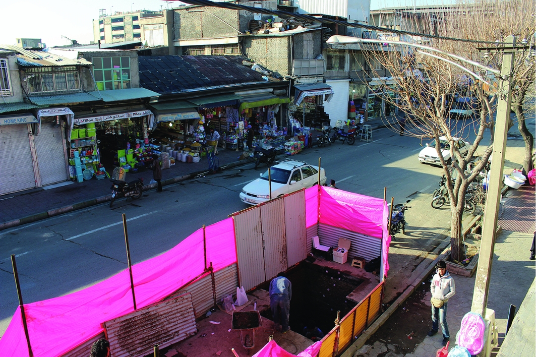
In 2013, sewer construction works in one of the busiest parts of Tehran yielded Islamic pottery sherds from the Safavid to Qajar periods (Figure 1). Following a visit by archaeologists from the Iranian Center for Archaeological Research, the author was appointed as the director of salvage excavations at archaeologically sensitive locations along the sewer line that had provided evidence such as potsherds, glass fragments, metal pieces and bricks. At the site of the Islamic pottery sherds, the excavation area was confined by a narrow strip alongside an extremely busy road (Figure 2). According to the Islamic sources, the fortified wall of ancient Tehran during the Safavid period (AD 1500–1736) had been located close to this excavation area. This Safavid wall was destroyed in the time of Persian King Naser al-din Shah Qajar (late nineteenth century). Its associated moat was filled in and a new wall was constructed around the capital.
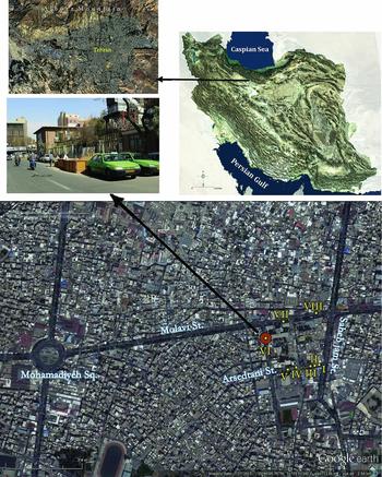
Satellite map of Tehran and location of the excavated trenches (top left map: M. Rokni; street photographs: M.E. Esmaeili Jelodar).
Trench 1 during excavation (photograph: M.E. Esmaeili Jelodar).
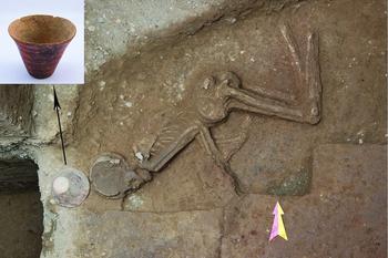
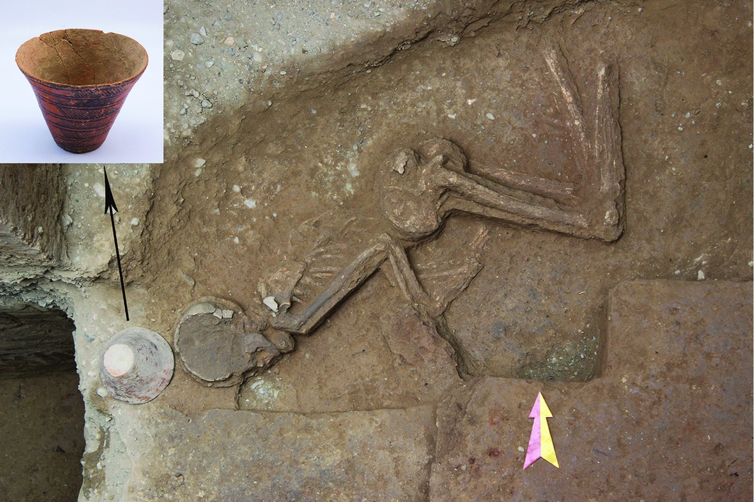
Altogether, eight small trenches were excavated along the sewer line. In all of these trenches, disturbed deposits and debris from the Late Islamic period were encountered immediately below the modern ground surface, representing traces of ‘ancient Tehran’ from the Safavid period onward. Remains of the nineteenth- and early twentieth-century street's brick pavement were also found in some trenches. The most important discoveries, however, comprised evidence of prehistoric occupation found deep below the modern ground surface. A prehistoric burial was revealed in trench I at a depth of 3.85m (Figure 3). The ceramic vessels accompanying the burial were characteristic black-on-red ware of the Cheshmeh Ali type, dating to the late sixth to mid fifth millennia BC.
The prehistoric burial in trench 1 and associated ceramic vessel (photograph: M.E. Esmaeili Jelodar and Farshid Mosaddeghi).
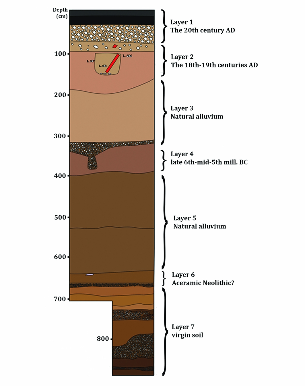
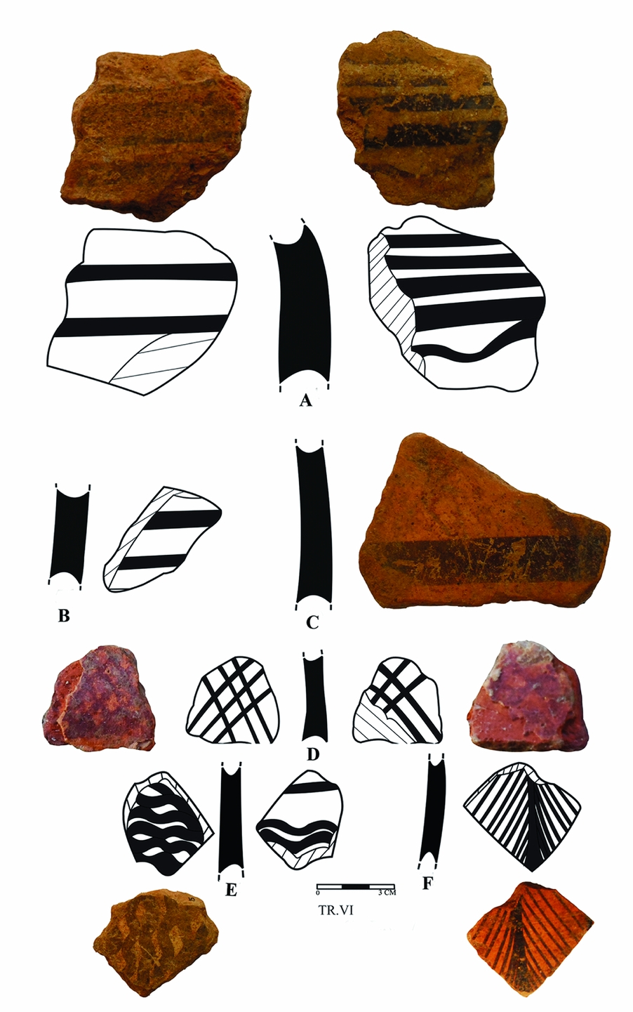
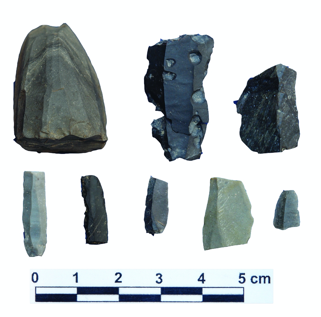
The only pre-sixth millennium BC evidence was found in trench VI, which was excavated to a depth of 8.85m below the surface. The stratigraphic sequence was divided into 24 loci, from 601 (the uppermost) to 624 (the lowermost). These loci can be condensed into seven chronological layers from the top-down (Figure 4). Layer 1 comprised an asphalt pavement and its gravel foundation, dating to the last 50 years. Layer 2, approximately 1.2m thick, was a mixed and disturbed deposit (including a burial covered by bricks) dating to the Late Islamic period—mainly the eighteenth to nineteenth centuries AD. Layer 3, approximately 1.2m thick, comprised natural deposits, mostly of small gravels at pebble size. Layer 4, approximately 0.7m thick, was a cultural deposit containing prehistoric ceramic sherds and some animal bones and lithics. The sherds, although few in number and mostly degraded, resemble those of the well-known Cheshmeh Ali culture (Figure 5). Layer 5, approximately 2.5m thick, was a natural deposit consisting mainly of sand and gravel. Layer 6, approximately 0.2m thick, was a cultural deposit containing chipped stone artefacts (Figure 6) and fragmented animal bones. Sterile layer 7 was excavated to a thickness of 2.2m.
The west wall's stratigraphic profile of trench VI (photograph: M.E. Esmaeili Jelodar).
Cheshmeh Ali ceramic sherds from trench VI (photograph: M.E. Esmaeili Jelodar).
The lithic assemblage recovered from trench VI, possibly dating to the Aceramic Neolithic (photograph: M.E. Esmaeili Jelodar).
Conclusion
The excavated sequence at trench VI represents, in general, three distinct periods interspersed with natural—probably alluvial—deposits. Artefacts and stratigraphy suggest that layer 6 could be dated to the pre-sixth millennium BC—probably to the Aceramic Neolithic. The lithic assemblage recovered from this layer comprises 20 pieces, including simple flakes, blades, bladelets, debris and a semi-bullet core. Just two pieces—one flake and one bladelet—show retouch on one edge. This collection, although small in number, contains elements (e.g. blades, bladelets and the semi-bullet core) similar to contemporaneous Aceramic Neolithic examples (e.g. Zeidi & Conard Reference Zeidi, Conard, Borrell, José Ibáñez and Molist2013). The stratigraphic position of the lithic-bearing deposit within layer 6—beneath natural sediments in layer 5—confirms the assemblage's relative antiquity. As previously mentioned, pottery from layer 4 can be dated to the Cheshmeh Ali period (late sixth to mid fifth millennia BC). Although no exact estimate for the time required to form alluvial-rich layer 5 can be provided, the absence of ceramics in layer 6 and the attributes of its lithic assemblage firmly suggest that layer 6 pre-dates the sixth millennium BC.
This new putative evidence for the Aceramic Neolithic from modern Tehran has significant implications for understanding the possible dispersal of the Neolithic from the Zagros eastward. Neither the Neolithic of north-eastern Iran (Roustaei Reference Roustaei2016; Roustaei & Nokandeh Reference Roustaei and Nokandeh2017) nor the well-documented Neolithic Jeitun culture of south-western Turkmenistan can be fully comprehended in the wider geographic context of the Near East without having a reasonable picture of the Neolithic period in the vast Iranian Central Plateau. The recent excavations in Tehran may provide the first evidence of a possible Neolithisation corridor between the Zagros in the west and the north-east region of the Iranian Plateau.
Acknowledgements
I would like to thank team members Farshid Mosadeghi, Behnam Ghanbari, Hamed Zifar, Mahsa Vahabi, Ashkan Avalli Poryan, Saeid Zolghadr, Iman Mostafapour, B. Kofgar, K. Khosrowsani, M. Shakoi and S. Saeidi, whose meticulous work made possible our achievements from the salvage excavations. Thanks also go to Siamak Sarlak, the former director of the Iranian Center for Archaeological Research, for assistance and administrative help during the project. I am deeply thankful to Kourosh Roustaei, who read and commented upon the manuscript. The project was jointly funded by the University of Tehran, the Tehran Wastewater Company, I.C.A.R. and the Research Institute of Cultural Heritage and Tourism.