
1. Introduction
As early as 1573, rumors traveled through Bahia that there were emeralds and diamonds in some remote spot in the region originally called Hivituruí by natives (today’s Serro, Brazil) and reached Lisbon. A century later, in 1672, King Pedro II of Portugal ordered the exploration of the Brazilian hinterland, where extensive gold reserves were discovered two decades later.Footnote 1 This milestone marked the beginning of the Portuguese occupation of the mountainous interiors of the Minas Gerais region and the subsequent influx of African slaves.Footnote 2 From then up to the nineteenth century this region saw attempts by the Portuguese Crown to control its colonial territory and exploit its mineral wealth, and also activities of smugglers who took advantage of every unexplored corner. Taken together, these efforts led to an accelerated depletion of resources.Footnote 3 By the 1820s, this scenario changed thanks to the arrival of new actors, namely British mining companies and mining experts from Central European, mostly German-speaking, countries.Footnote 4 However, mining continued to be closely tied to the mapmaking of Minas Gerais and the availability of slave labor.Footnote 5 Indeed, a “black slave” by the name of Joao Paulo found the first diamond in itacolumite rock in Minas Gerais in 1827, and, according to a popular story, clandestinely extracted such diamonds on Sundays and holidays for almost ten years.
In 1836, rumors of his spectacular find spread at lightning speed, boosting mapping efforts and the exploitation of the mines in Serra do Grão Mogol. In a May 1846 meeting of the Viennese circle of naturalists, Joao Paulo’s story was told by Habsburgian mining engineer Johann Karl Hocheder, who had worked as a “chief manager” for British mining ventures in Brazil in the 1830s.Footnote 6 Hocheder had heard the rumors from Virgil von Helmreichen, another Habsburgian mining engineer who worked in the region exploring gold deposits on behalf of companies financed by British capital, like the Imperial Brazilian Mining Association in Gongo Soco.Footnote 7 Taking this episode as its starting point, this article will explore Helmreichen’s role as a player within the imperial networks of mining exploitation that shaped the larger process of global territorialization of Minas Gerais during this period.
European cartography was the primary discipline to visually represent and order the distribution of global spaces in the nineteenth century. Consequently, the paper’s first section summarizes the “modern” mapmaking of Minas Gerais as carried out by mining experts who had migrated from the German states. My second section explores rumors of covert mining in the region and how their global circulation elicited massive British investments. I argue, in particular, that such diamond and gold mining by slaves was fundamental to the expansion of the economic frontier and the mapping of this region. My third section focuses on Helmreichen and his output as a mining engineer in Brazil. His reports for mining companies and technical scientific publications in the Imperial Academy of Sciences in Vienna reveal cooperation across diverse imperial spaces. Seeking to recover a “missing link” in the connected histories of knowledge and capitalism, I examine Helmreichen’s biography, which has never been explored thoroughly. It provides valuable evidence of a group of Austro-German expert networks closely entangled with British imperialism in nineteenth-century Brazil.Footnote 8 This case also contributes to the growing interest in the overlooked impacts the Habsburg Empire had in overseas colonial territories.Footnote 9
Given these goals, it is crucial to have a broader understanding of the historical formation of the territory of Minas Gerais in its global context. Questions of territoriality have become a productive field of historical inquiry, challenging teleological notions of national narratives. An influential current in global history informed by the “spatial turn” claims that territory is not a mere background factor.Footnote 10 The emphasis on territoriality as a historical formation allows for a new periodization oriented toward explaining processes of globalization related to the exploitation of material resources, the distribution of political power, and the forging of social alliances, especially in the modern era.Footnote 11 As the nineteenth century began, globalization was at a critical juncture due to the new regime of territorialization based on the development of processes of standardized learning and the most efficient forms of political, economic, and cultural order.Footnote 12 I will argue that the territorialization of Minas Gerais is a paradigmatic case for this period. By stressing the global entanglements that shaped the territory, I draw attention to the importance of better incorporating often-neglected Latin American processes and trajectories and rich related historiographies into global history debates.Footnote 13
The history of the mapmaking of Minas Gerais is fertile ground for exploring the global formation of the territory. In particular, mapmaking was an important aspect of constructing the “imperial archive”Footnote 14 since it was a way to obtain reliable and “rational” certainty about local mineral resources. Mining rumors that reached London and Vienna sparked the quest for territorial control in the form of a global gold rush inspired by the discovery of mines in California, Mexico, and Australia.Footnote 15 As Mountford and Tuffnell (Reference Mountford, Tuffnell, Mountford and Tuffnells2018) have emphasized, gold seekers were the creators and products of global interactions that shaped the broader course of nineteenth-century history. Gold rushes had profound impacts on the territories and societies in which they took place by rapidly mobilizing exchanges of people, knowledge, investment, and technological innovation and stimulating processes of adaptation, capitalist exploitation, and environmental transformation. Therefore, the global demand for mining knowledge and the subsequent mapping of areas with mineral resources, like Minas Gerais, should be understood within the framework of what some scholars have called the territorialization process. According to the geographer Casti, territorialization consists of continuous practices of denomination, reification, and structurization, all of which together imply the intellectual “modelling” of a territory with a view to facilitating physical control and administrative management, and “the creation of operational contexts for the execution of social projects” (Reference Casti and Lévy2017: 145–49). Maps are fundamental to these practices because they are the medium through which the processes are operationalized. In the same vein, Brazilian historians Kantor, Piccolotto Siqueira, and Ferlini (Reference Kantor, Piccolotto Siqueira and Amaral Ferlini2009) refer to a “lived” cartography as they analyze the complex sedimentations of knowledge and territory. They explore the dynamics of mapping; tensions between the state, local actors, and foreign interests; and strategic uses of charts in how the identities of specific spaces are constructed. Studying the transformation of mining rumors into maps allows us to grasp how the “lived” cartographic production of Minas Gerais and the global circulation of rumors were interconnected.
By focusing on Minas Gerais and its territorialization during the expansion of the capitalist world economy in the first half of the nineteenth century, I will also illuminate the global entanglements caused by imperial aspirations for exploitable mineral wealth in this region. These aspirations led to the formation of a coalition between the Brazilian Empire, British mining enterprises, and a community of mining experts from the German states who were expected to generate reliable “scientific” information on mineral deposits and where they could be found. This complicated joint venture was, again, the product of rumors about alleged spectacular findings in new mines, spread “from below” by slaves and black freedmen for their own purposes. The expansion of the mining frontier in this region depended, then, on surreptitious territorial exploration by slaves and black freedmen, like Joao Paulo in Serra do Grão Mogol, and on the technical improvements in underground surveys developed by Habsburgian engineers like Helmreichen. In a novel capitalist configuration set up by the Brazilian-British companies, Joao Paulo and Helmreichen operated with different but convergent agencies. While the former sought to gain his freedom through covert mining in unexplored regions, the latter sought scientific recognition by enhancing the exploitation of those regions. Despite their different primary motivations, each contributed in his own way to expand the mining frontier in nineteenth-century Minas Gerais.Footnote 16 In this novel configuration set up by the Brazilian-British companies, men like Joao Paulo and Helmreichen operated with different but convergent agencies.
This scenario analyzed here reflects the diverse spaces of interaction under multiple forms of domination and exploitation in what one group of scholars has called “zones of the second slavery.” This phrase is meant to contradict grand narratives of modernization and liberalism, and was originally proposed to describe nuanced continuities of forms of forced labor and their formative correlation to the emerging industrial reconfiguration of the nineteenth-century capitalist world economy.Footnote 17 Rood (Reference Rood2017) has demonstrated the role played by slave skills during this same period in the development of new production processes and technologies in plantation economies in the Greater Caribbean. We can trace mining histories elsewhere that were parallel to that of Minas Gerais. For example, José Álvares Maciel, an engineer born into a well-positioned family in Ouro Preto, reported from Angola about African iron techniques that later reached Brazil through Portuguese slave networks.Footnote 18 That is, I argue, more dynamic and intertwined forms of knowledge production were at the core of the industrious situation of the “second slavery.” The interlocking of “second slavery,” commodity frontiers, and knowledge has usually focused on the study of plantations as part of the thriving scholarship in the new histories of capitalism;Footnote 19 this paper repositions this issue by looking at the thread connecting Joao Paulo and Virgil von Helmreichen through Brazilian-British mining undertakings in Minas Gerais.
As the article will show, the complex transition from the Latin American colonial system to independent states indicates, not a rupture, but rather an amalgamation of diverse practices of formal and informal imperialism. That is, the Brazilian structure of slavery, inherited from the colonial period, was complemented by British infrastructural development and investment, and the emerging scientific elite from the German states and the Habsburg Empire.Footnote 20 My goal is to examine the degree of connectivity and cooperation across these diverse imperial spaces and expert networks in and beyond Minas Gerais. To this end, I analyze processes of state-related production of knowledge and its “trans-imperial” circulation as tied to mining and cartography in the Central European and Atlantic contexts.Footnote 21 Keeping in mind Raj’s critical approach (Reference Raj2006; Reference Raj2017; Reference Raj and Findlen2018), my analysis of these trans-imperial spaces of circulation will take into account the asymmetries of power in the processes of encounter, negotiation, and reconfiguration of knowledge production; in other words, I will not conflate circulation with fluidity.Footnote 22 The case study thus renders visible the global dynamics at play in its examination of the British interest in the discovery of new mines, the anxiety to produce expert knowledge at the local level, and the desire of the Brazilian government to map and control Minas Gerais.Footnote 23
2. The Mapmaking of Minas Gerais in the Nineteenth-Century Expansion of the World Economy
For a comprehensive view of the different imperial engagements in nineteenth-century Minas Gerais, the region must be understood as a globally interconnected space populated by natives, Africans and mestizos (slaves and freedmen), the Brazilian criollo elite, German migrants from military backgrounds, Habsburgian mining engineer experts, and British mining company representatives.Footnote 24 These British companies were the product of a public-private partnership that brought together British capital and the Brazilian Empire, giving a new impetus to mining in the region from 1824 onward.Footnote 25 With the arrival of British investments, the elite of Minas Gerais reinforced their local influence and wealth through their intermediary role as landowners of mining zones and as slave traders.Footnote 26 Minas Gerais had the largest slave population in Brazil, the result of a diversified economy, from plantations to mining, and an inner slave trade.Footnote 27 By introducing the German and Habsburgian experts into my analysis, I approach the connected histories of slavery, mining knowledge, and capitalism in nineteenth-century Minas Gerais and, following Tomich, explore “how world economic processes produce particular local histories and how such histories structure the world economy as a whole” (2018: 1).
The British-Brazilian capitalist cooperation can be traced back to two interrelated events: the transatlantic journey of the Portuguese King Joao VI and his family to Brazil, escorted by the British navy, in 1808, and a new commercial regime that gave British traders a preferential status in Brazilian ports starting in 1810. In 1822, this “British pre-eminence” in Brazil was reinforced when the successor to the Portuguese crown, Prince Pedro, declared independence from Portugal with the backing of local allies. The declaration founded a constitutional monarchy, and he became Emperor Pedro I of Brazil. As a result of this declaration of “imperial independence,” he broke with the Portuguese Crown and instead strengthened new imperial alliances, especially with the expanding British free-trade networks in Latin America.Footnote 28 The new constitution of 1824 allowed foreign capital to acquire mining concessions with special requirements. In addition to a deposit to the Treasury as a guarantee against taxes and duties, foreigners had to pay taxes 5 percent higher than Brazilians paid and one-third of their company’s stocks had to be offered to local agents. This legal opportunity had counterparts in London joint stock ventures, which had already boosted mining speculation throughout Latin America.Footnote 29 The list of British-Brazilian mergers in Minas Gerais in the first half of the nineteenth century is therefore lengthy, given the very nature of mining ventures. Many of the enterprises were speculative prospecting partnerships that lasted only a few years or sometimes just months. The Imperial Brazilian Mining Association (1824–1856) and the St. John d’el Rey Mining Company (1830–1960) were among the most established companies.Footnote 30
Relevant contributions have recently been made to the history of cartography in Latin AmericaFootnote 31 and particularly this Brazilian region.Footnote 32 Arguably, the mapping of Minas Gerais is central to the history of Brazil in that the imperial need to map mineral riches was one reason the Portuguese crown was forced to delimit the edges of its colony in the Americas. Moreover, the delimitation of inner borders and the subsequent organization of captaincies, intendencies, and comarcas aimed to improve territorial and fiscal control over the exploitation of gold and diamond mines.Footnote 33 Thus, maps as geographical narratives played a significant role in the construction of national but also provincial identities dating back to the colonial era.Footnote 34 Their rhetoric—their desire to communicate—must also be considered in order to understand the performative scope of cartographic production, as Kramer (Reference Kramer2014; Reference Kramer2015) clearly states about the maps of the Brazilian Conquest. Unlike seventeenth- and eighteenth-century maps, the “new” and much more accurate maps from the first half of the nineteenth century in Minas Gerais reveal other conditions of cartographic production that were overdetermined by intense global entanglements. Coincidentally, these maps and geological surveys were mostly designed by German-speaking experts with backgrounds in the military or mining engineering. Even if these cartographic techniques originated as early as the late seventeenth century in the German states, applying them to another space required local adaptation. As members of the expert elite, mining engineers like Hocheder and Helmreichen exemplified the professionals who intensively cooperated with the driving forces of imperial capitalism in nineteenth-century Brazil.Footnote 35 These German and Habsburgian mining experts made up the “capitalist vanguard” of the nineteenth century in Latin America, in a setting where new management and knowledge services were required to organize and supervise the exploitation of natural resources.Footnote 36 The mapping of Minas Gerais was thus the product of new alliances, jointly funded by Brazilian authorities with an interest in “modernizing” a provincial state,Footnote 37 foreign capital supplied by British banks and mining magnates,Footnote 38 the local elite interested in land sales and trading slaves, and mining experts from the German states.
Existing research on colonialism and imperial mapmaking tends to focus on “horizontal” or “surface” cartographies and consequently overlooks mappings concerned with subterranean regions.Footnote 39 On the other hand, the iterative mapmaking projects of Minas Gerais in the nineteenth century were closely tied to the geological surveys conducted by German-speaking experts like Hocheder and Helmreichen, and were the result of expansive transatlantic knowledge networks of cartography and mining expertise.Footnote 40 As I explain in this section, visual evidence including both “horizontal” and “vertical” mappings reveal the imperial aspirations underlying even the first illustrations of “natives and wildlife” in the eighteenth century. Those culminated in the geometric precision of maps and the vertical representations of underground mines in the nineteenth century. This visual evidence indicates the first phase of an advancing interior frontier and territorialization, and a second phase of territorial control and global modernization accompanied by underground exploration.
The historical accounts of the mapmaking of Minas Gerais go back as far as the Treaty of Madrid (1750) and its Mapa das Cortes.Footnote 41 However, the symbolic and documentary potency of the images of two subsequent maps of the mining region sufficiently illustrate the relationship between the territory, its cartographic construction, and the discursive configuration of this Brazilian region within the global economic and political order.Footnote 42 Analysis of these maps sheds light on the imperial aspirations and on the new actors mobilized for such mapmaking, indicating an intensified transatlantic circulation of mining knowledge during this period.
In the two images I analyze here, the Mapa da Comarca de Sabará (1778) and Carta Geographica da Capitania de Minas Geraes (1804), it is possible to identify colonial legacies in cartographic production and their role in prospecting within the mining territory. The earliest illustrations on maps of Brazil showed cannibalism, the felling of brazilwood trees, and the “primitivism” of the indigenous populations.Footnote 43 After that first phase of exoticism, the Mapa da Comarca do Sabará (1778), drawn by Portuguese military engineer José Joaquim da Rocha, shows evidence of a more “modern” cartographical attitude.Footnote 44 This image, set in the corner of the map, illustrates a dark-skinned, mostly naked native kneeling, pointing a bow and arrow at a bewigged, elaborately dressed, seated white-skinned European holding drafting materials. Both are set against a backdrop of trees, including an exotic palm. This shift was not just because European experts no longer depicted cannibals that recalled the Christian reception of Graeco-Roman tradition, but also because the very act of mapping had been transformed into a powerful weapon with which to dominate territories occupied by native populations. The bow and arrow were symbolic as a “primitive” instrument set in opposition to the enlightened cartographer’s compasses and calm face in an image that can only be considered meta-cartographic (image 1). Neither was domination limited to territorial expansion alone, since natives were seen as part of nature itself, as shown in the nakedness of the indigenous figure. From Kantor’s claims about the role of cartography in constructing local identities,Footnote 45 it can clearly be inferred that this image alludes to aspirations for prospecting and exploitation of natural resources.Footnote 46 The association of knowledge with power and the domination of culture over nature thus becomes more explicit.
Detail from the map by José Joaquim da Rocha, Mapa da Comarca de Sabará, 1778, Arquivo Público Mineiro, APM-BH, at: www.siaapm.cultura.mg.gov.br/acervo/grandes_formatos/SC-005/747.jpg (last visited 28. Feb. 2022).

The illustration in the Carta Geographica da Capitania de Minas Geraes (1804),Footnote 47 compiled by Caetano Luiz de Miranda only four years before the Prince Regent (later King Joao VI) opened Brazil’s borders to foreign expeditions, had also referred to these dualities,Footnote 48 but to symbolize a peaceful alliance between the explorer and the native (image 2).Footnote 49 Even in the older image, the indigenous figure is best understood as a personification of nature and its riches, with his open hand beckoning the explorer toward the natural resources of the mining region. Indeed, the Prince Regent had created the Real Gabinete de Mineralogia in Rio de Janeiro in 1810 (transferred to the Military Academy in 1811) with the intention of “modernizing” mining knowledge in his empire. The council’s first director was German mining expert Wilhelm von Eschwege, who headed the Fábrica de Ferro Patriótica in Congonhas do Campo in 1812 and had been the first to mine iron in Brazil;Footnote 50 he went on to publish the first geological map of Minas Gerais in 1821.Footnote 51 Eschwege’s was not the only Germanic contribution to this endeavor. Prince Maximilian zu Wied-Neuwied arrived in 1815 to explore the region, and the Austrian Brazilian Expedition began in 1817, with participants including the likes of Carl von Martius, Johann von Spix, and Johann Natterer.Footnote 52 By 1824 Minas Gerais had become the preferred destination for mining enterprises, driven by British capital.
Detail from the map by Caetano Luís Miranda, Carta Geographica da Capitania de Minas Geraes, Arquivo Histórico do Exército, Rio de Janeiro, AHEX-RJ, 1804, at: http://www.repositoriotoponimia.com.br/arquivos/cap-miranda-1804-aehx_1.jpg (last visited 28 Feb. 2022).

As territorial knowledge became less fanciful and more utilitarian, illustrations like those analyzed above ceased to appear in the new nineteenth-century cartography. Instead, the imperial gaze manifested itself in the geometric accuracy of measurements and the meticulous listing of the coordinates of the mines. The later map of the whole province of Minas Gerais (1855, 1862) had crossed hammers as the by-then typical symbol of mining, accompanied by the slogan “Minas d’Ouro em trabalho” (Working gold mines). Production of this map of the whole province had been arranged by Carneiro de Campos’s government and was drawn up by Friedrich Wagner and Heinrich Halfeld.Footnote 53 Born in Bohemia to German parents, Wagner had fought in the Habsburgian army against Napoleon. He then worked in the mining sector in Bohemia and arrived in Brazil in 1824 for mineralogical expeditions, occupying several official posts with the title of “engineer,” despite having no academic training. Among his other positions, Wagner was state geographer for Minas Gerais for decades and, as such, published the first map of the province in 1855.Footnote 54 However, it was Halfeld who produced the final and more accurate map of the region in a 1:2,000,000 scale, following the contemporary German trend in cartography. Born in Hanover, Halfeld had also fought against Napoleon, but unlike Wagner, he went to Brazil in 1825 as part of the Brazilian imperial army’s corps of mercenaries.Footnote 55 Also unlike Wagner, Halfeld actually was a mining engineer, trained at the Mining Academy in Clausthal. He was hired by the General Mining Association between 1827 and 1828 and the Imperial Brazilian Mining Association between 1830 and 1832. Annual reports from these British companies refer to Halfeld several times as an authority in mining exploration.Footnote 56 He was also hired in 1836 as “provincial engineer” responsible for the construction of the Estrada do Paraibuna road, which connected the central region of Minas Gerais with the capital Rio de Janeiro.Footnote 57 The mapping of Minas Gerais clearly went hand in hand with the modernization of Brazil’s state infrastructure,Footnote 58 shaped to a great extent by a group of migrant professionals of the emergent global bourgeoisie.Footnote 59 We can deduct from the biographies of both Wagner and Halfeld that the Brazilian Empire needed experts who had cartographic expertise but also a background in mining engineering.
The “modern” cartography represented by Wagner and Halfeld’s work must also be compared with earlier publications such as Reise in Brasilien in den Jahren 1817–1820 (Munich, 1823–1833), by Spix and Martius.Footnote 60 The four-volume publication was the result of a scientific expedition sponsored by Habsburgian and Bavarian aristocrats and was paradigmatic in the representation and exploration of the Brazilian territory in the early nineteenth century. It included an atlas with a variety of illustrations: indigenous people with their faces painted, war and hunting artefacts, diverse flora and fauna, sophisticated representations of landscape, and transcriptions of indigenous symbology. The atlas also contained maps of the different regions in Brazil but without human references, in keeping with the more modern cartographic style. Additionally, two vertical geological representations of territories were published as an appendix.Footnote 61 These geological panoramas mapped the height of the sierras, the depth of the rivers, and the distribution of vegetation by altitude. This last vertical mapping details the different regions from Rio de Janeiro to Minas Gerais via São Paulo, as well as the land quality based on agricultural production (corn, sugar, tobacco, coffee, manioc, bananas, etc.) and some livestock samples. The only human figure in the four levels of this vegetation map is featureless and dark, with feet in the river and the caption under it, “Entrance to the gold formation” (images 3a and 3b). The erudite naturalist and cartographer of the time would have interpreted this figure as a slave washing gold and diamonds in the river, much like another portrait in the same atlas that portrayed mining activities (image 4).
Detail of Johann B. von Spix and Carl P. von Martius, Reise in Brasilien in den Jahren 1817–1820, Munich, 1823–1833, “Vegetations-Karte,” 43.
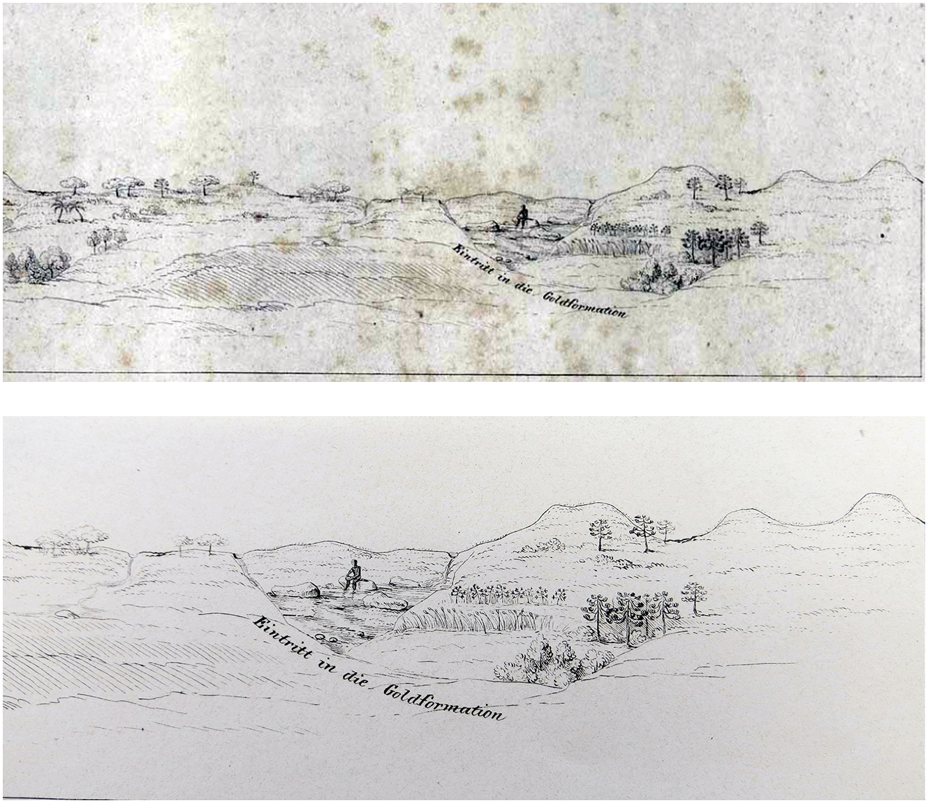
Detail of Johann B. von Spix and Carl P. von Martius, Reise in Brasilien in den Jahren 1817–1820, Munich, 1823–1833, “Vegetations-Karte,” 43.

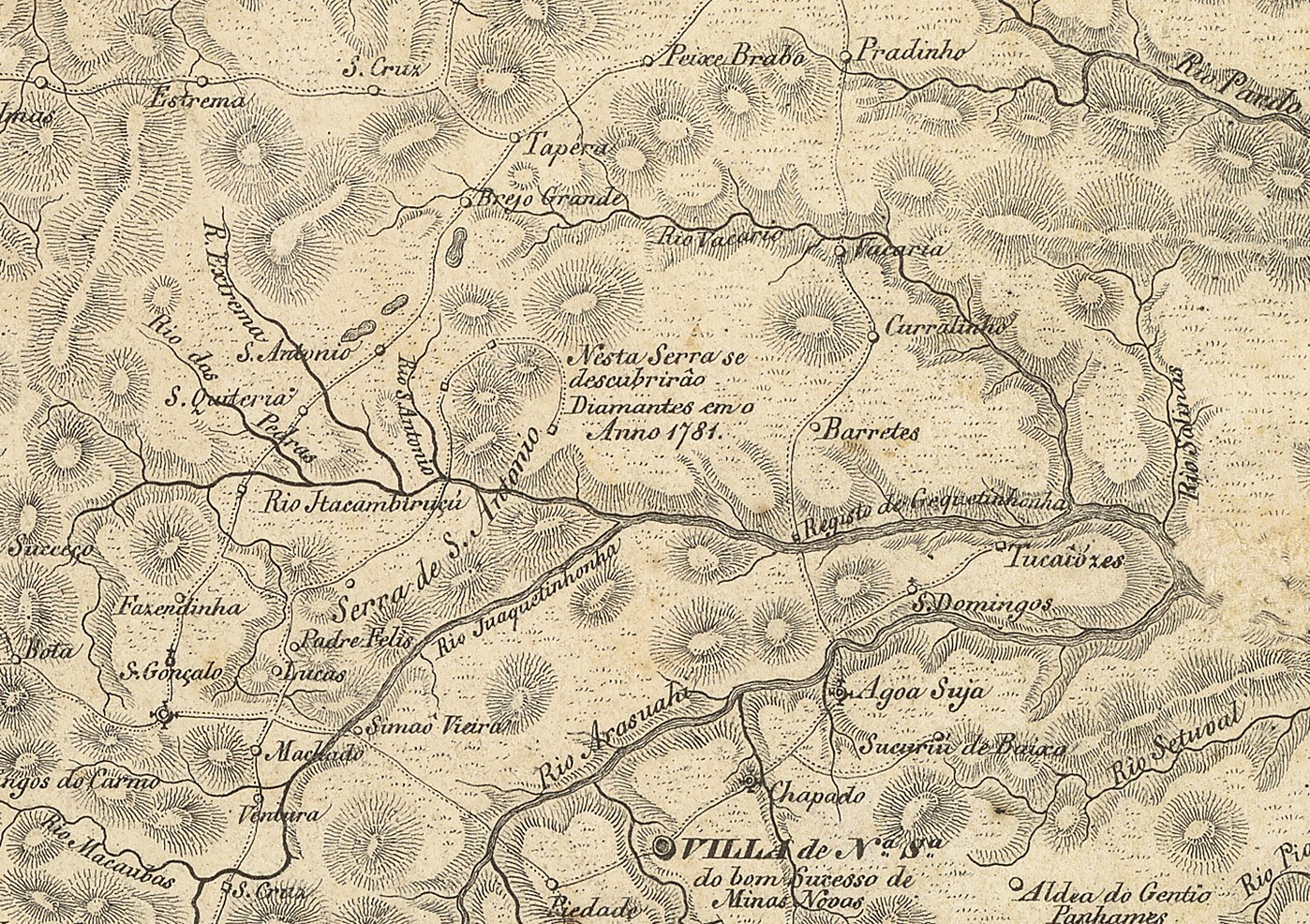
These images, along with those analyzed above, reveal the imperial semiotics used within cartographic representations and geological surveys. It is possible to trace the transformation of mining as a process of territorialization in how it is represented within increasingly globalized cartographic productions, from the illustrations of the natives in the earliest charts, to the images of enslaved miners in Spix and Martius’s Atlas, to the crossed hammers in Halfeld and Wagner’s nineteenth-century map. In the same vein, they reveal the enforced dehumanization of Africans and the violence involved in the ways maps rendered (in)visible the experience of enslaved miners during the “second slavery.” However, these maps and geological surveys should not be viewed solely as a description of the contemporary state of knowledge about the territory: they were also a means to project the imperial potential onto future endeavors. In other words, these representations are not mainly about what was dominated and known, but rather what could still be exploited. This is why individuals like Eschwege, Halfeld, Hocheder, and Helmreichen were commissioned: to explore and map the territory in terms of its exploitable mineral wealth. These mappings constructed, then, both imagined riches for foreign speculators and the local identity that structured the social space toward a capitalist world economy. In the case of mining rumors, spread first by the slave Joao Paulo in Serra do Grão Mogol at the intersections of the rivers San Antonio and Itacambiruçú (image 5), the maps of Minas Gerais chronologically evidence the territorialization of this specific region and the desires they communicate by writing on the cartographic surface “Serviço diamantino” (diamond mining service; image 6) and later adding the crossed hammers as a typical symbol of mining (image 7).
The location of Grão Mogol on the northeast side of the intersection of rivers San Antonio and Itacambiruçú is not indicated. It was written on the map that diamonds were discovered there in 1781. Planta Geral da Capitania de Minas Geraes, Lithographer R. Schlicht, [183?], Mannheim, Biblioteca Nacional Brasil, ARC.007,01,010 (last visited 28 Feb. 2022).
Note the many mentions of “Serviço diamantino” around Grão Mogol. Heinrich Halfeld, Friedrich Wagner, and Johann Jakob von Tschudi, “Die brasilianische Provinz Minas Geraes: Originalkarte nach den offiziellen Aufnahmen des Civil-ingenieurs H.G.F. Halfeld, 1836–1855, unter Benutzung älterer Vermessungen und Karten gezeichnet von Friedrich Wagner. Beschreibender Text von J. J. Tschudi.” Petermanns Mitteilungen 8, Supplement Series 9 (Gotha, J. Perthes, 1862).

The key to this map indicates that crossed hammers refer to mines. Heinrich Gerber, Carta da Província de Minas Geraes, coordenada por ordem do Exm. Sr. Conselheiro José Bento da Cunha Figueiredo, segundo os dados offiçiaes existentes e muitas próprias observações por Henrique Gerber, engenheiro da mesma província (Glogau, C. Flemming, 1862), Biblioteca Nacional Brasil, ARC.019,07,022, at: http://objdigital.bn.br/objdigital2/acervo_digital/div_cartografia/cart540207/cart540207.html (last visited 28 Feb. 2022).

3. Local Rumors in the Age of Gold Rushes
The geological surveys and eventual mapmaking of Minas Gerais were the product of extensive and concentrated processes of state-related knowledge production and thus can be considered part of the “imperial archive.” Recent debates on the history of cartography have demonstrated that such maps and geological surveys were not only instruments of territorial control but also the means by which imperial aspirations were demonstrated visually. This is especially true when one considers the allied interests of British capitalists and Habsburgian experts in this Brazilian region. According to Casti (Reference Casti and Lévy2017: 143), maps can be understood as “agents capable of deploying self-referential information to mold human action on territories.” Thus, territorialization and mapmaking can collaborate dynamically not only through rational choices but also through more speculative endeavors like seeking new mines. Above all, the geological surveys of Minas Gerais from the first half of the nineteenth century document the emotional dimension inherent in the British mining ventures in Brazil. These surface and underground mappings did not merely represent territory: they operated speculatively on the affective level by raising hopes, which enabled the continuous mobilization of financial capital and labor (both slave and expert) with a view to future prospecting.Footnote 62
As indicated, mining rumors were at the heart of the Portuguese territorial occupation of Minas Gerais from the start. Crucial to this process was the bottom-up dynamics of the garimpos, a form of small-scale illegal mining, which led to further discoveries of new sources of wealth in aquifer areas.Footnote 63 Wilhelm von Eschwege attributed the discovery of many mines that made up Minas Gerais to a group of three hundred freemen garimpeiros, who were either armed or colluded with the colonial authorities.Footnote 64 Some garimpeiros even became small-time suppliers for the state’s mining network starting in the early nineteenth century. The clandestine mining of garimpeiros also spread rumors about new reserves, promoting the idea of a gold rush, which attracted more investment and led to the need to map every inch of Minas Gerais.Footnote 65 These rumors also aroused the interest of scientific circles in Vienna as well as experts like Helmreichen from the Mining Academy of Schemnitz (today Banská Štiavnica, Slovakia). Helmreichen explained the influence of the garimpeiros in the development of mining in Minas Gerais during the 1830s in a letter, stating that their furtive explorations could lead to violent competition and that garimpeiros could even earn their freedom if they found new mines.Footnote 66 The “pervasive rumors” (ausgestreuten Gerüchte), as Helmreichen called them, of new findings in unexplored areas accelerated the processes of territorialization. However, he added, it was hard to assess whether or not the rumors were based on truth and if there was indeed the potential to establish new mines. Nevertheless, spreading rumors was arguably a way of generating speculation, raising capitalist anxieties in the potential of mining ventures, and attracting more investors, whether in London, Rio de Janeiro, or Vienna, and it was thus a fundamental aspect of prospecting. Unlike other texts written by Helmreichen, including his reports for the Imperial Brazilian Mining Association, geological mappings, thermal measurements, and mine plans, this letter offers a rare insight into the social dimension of such mining endeavors.Footnote 67 Most significantly, it reveals the agency of the garimpeiros as territorial explorers and generators of rumors, appealing to the affective dimension of hopes, and by extension, of capitalist aspirations across the Atlantic.
From a methodological perspective, the study of rumors and gossip as a form of “uncertain knowledge” enables us not only to overcome binary models of “true” or “false” data, but also to approach knowledge from its alleged margins by investigating such instances of insecurity and instability. This approach is useful for reconstructing the role of the garimpeiros, in particular, since evidence of formal knowledge production is scant in this instance.Footnote 68 In addition, rumors were key to mining enterprises because they made it possible to mobilize highly desirable human and technical resources. In other words, rumors helped mobilize future investments. Mining experts like Helmreichen referred to this phenomenon as Berggeschrey (“mountain clamor”). As Asmussen and Long explain (Reference Asmussen2020), Berggeschrey has been a legal concept since the Middle Ages, and one can recognize its performative nature.Footnote 69 As the clamor over the discovery of new mines operates on both a material and affective level, it follows that such a discovery would vibrate with “unleashed wishes for wealth and affluence but also [create] anxieties and unrest.”Footnote 70 The reference to the “pervasive rumors” in Helmreichen’s letter can thus be interpreted as rooted in this affective force of prospecting and thereby propelling material desires. Indeed, by the late eighteenth century, the German terms “Gerücht” (rumor) and “Geschrey” (clamor”) were associated through their mutual connotation of spreading the word about something.Footnote 71
These affective aspects of mining in Brazil, especially in Minas Gerais, were also influenced by the British prohibition of the slave trade, and by the labor migration to plantations in Bahia. Moreover, the construction of a road known as the Estrada do Paraibuna, which connected Minas Gerais with the imperial capital, drew away much of the area’s manpower—both slaves and freedmen, experts and non-experts—from 1836 onward.Footnote 72 These three factors increased costs and made mining less profitable for British investors. In addition, Eschwege and Helmreichen described a high level of violence in both legal and illegal mining, which created unstable conditions unsuited to prospecting. In the late 1850s, the Swiss naturalist Johann Jakob von Tschudi declared that there was now “calm and legal order” in Minas Gerais and that similar scenes could be found in California and on Australia’s east coast, and this was reported by the London press.Footnote 73 The accounts from these sources demonstrate the relevance of the “bottom-up” dynamics of mining, which an “objective view” of maps and the vertical third dimension of geological surveys cannot really capture. Mapmaking in general, and geological cartography in particular, thus served as a means to introduce certainties into the “irrational” affective world of mining rumors and speculative hopes.
Helmreichen’s commission to explore and report on the mines was not only a way of controlling the territory but also an attempt to visualize rationally the aspirations of mining wealth in Brazil. His detailed scientific reports and accurate maps were thus meant to send out comforting messages to both Brazilian state officials and British investors, who were all subject to rumor in one form or another. The cycle was fairly predictable since rumors from Minas Gerais reached London at an early stage and were institutionalized and formalized by the British press in news and reports. The rumors became the origin points in the process of diffusing definite information, and as such acquired greater credibility through the press and expert publications. Some of these mining rumors reached publications with a technical and financial emphasis dedicated almost exclusively to global mining activities, and thus became highly formalized.Footnote 74 For example, some of the interest in global mining can be traced back to two of Benjamin Disraeli’s publications.Footnote 75 Both pamphlets compiled many statistics from Latin America and North America and showcased the state-related knowledge circulating on mining issues from legal regulations to productivity. Another relevant example is the trade magazine Mining Journal and Commercial Gazette, founded by Henry English in London in 1835, to which the Habsburgian mining engineer Hocheder also contributed.Footnote 76 The general press, too, reported on mining activity in different parts of the world. On 20 January 1849, the Illustrated London News brought industrial images of Brazil’s mining region to its readers. They showed local landscapes alongside technical illustrations of the work done in the mines (image 8). This second type of technical illustration was typical in showing expertise in mining engineering, as Eschwege’s image also shows in “Master Plan and Profile Outline of English Gold Mining Company in Gongo Soco” (image 9), published in Pluto Brasiliensis (Reference Eschwege1833).
Details of “Gold Mine in Brazil,” Illustrated London News, 20 Jan. 1849: 47.

Wilhelm von Eschwege (Reference Eschwege1833): Pluto brasiliensis. Berlin, panel V.

Such technical drawing was fundamental in transmitting a promising sense of security to London investors and in creating, more broadly, an international elite community with mining expertise on a global scale. Maps and geological surveys turned Minas Gerais into a legible, calculable, and productive territory worthy of financial investments from British mining enterprises. The vertical mapping of the British gold mine in Brazil designed by Eschwege, for instance, is the epitome of a long tradition of expert codified knowledge among German and Habsburgian mining experts. From the end of the eighteenth century, the institutionalization of mining academies in the German states (Freiberg, Clausthal) and the Habsburg Empire (Schemnitz) established an elite group of experts to develop ways to exploit mineral wealth by intensifying the production of mining knowledge. The circulation of this knowledge in transatlantic contexts and multiple imperial spaces was crucial in territorializing Minas Gerais.Footnote 77 The mining know-how made it possible to extract relatively reliable and profitable knowledge from the rumors, allowing it a significant impact when complemented by logistics of transport and investment from the British free-trade imperialists and the structures of slavery inherited from the colonial period in the Brazilian Empire.Footnote 78 Helmreichen played a key role in connecting the Brazilian and British mining elements with the Habsburgian experts by finally converting mining rumors into more reliable technical certainties through an “objective” visualization of the underground world.
4. From Schemnitz to Gongo Soco: Virgil von Helmreichen, a Habsburgian Mining Engineer in Brazil
The history of science in the Habsburg Empire during the nineteenth century has its own global implications. Historiography has contributed overseas expeditions as relevant cases of science and imperialism. A well-researched case is the Austrian Brazil expedition from 1817 to 1835, made in honor of the marriage between Maria Leopoldina of Austria and the Prince Pedro, the numerous collections of which are today a part of the Viennese cultural heritage. Another canonical example is the Novara expedition, a joint science and navy project that set sail in 1857 for Ceylon and Auckland, returning through the Americas.Footnote 79 In contrast, the history of Habsburgian mining experts in Brazil in the first half of the nineteenth century has not been extensively explored, even though they had acquired an international reputation by the late eighteenth century.Footnote 80 A telling example is the new kind of alliance established when Hocheder held manager positions in British mining companies in Minas Gerais. After his early contact with the Imperial Brazilian Mining Association, he was appointed chief mine manager and later superintendent within the same company, which allowed him to bring over Virgil von Helmreichen.Footnote 81 This history accounts for the “trans-imperial” cooperation between the Habsburg, British, and Brazilian Empires, but also, and above all, the role played by the circulation of mining knowledge in the region’s territorialization.
Helmreichen died in Rio de Janeiro in 1852 after an expedition to Paraguay to map the Bermejo River, authorized by President Francisco Solano López. His private papers in the Austrian Academy of Sciences contain plans of mines, geological surveys, sketches of maps, publisher’s proof copies, drawings of natives, notebooks written in English with notes, and astronomical and meridional measurements.Footnote 82 The original records from 1853 also mention the existence of a map of Minas Gerais that is no longer in the archive.Footnote 83 The notebooks, though, contain references to the map that Wagner and Halfeld had been working on. Helmreichen arrived in Brazil in 1836 thanks to Hocheder, whom he met while working with the Regulatory Commission of Mines and Metal Factories of Salzburg.Footnote 84 Hocheder and Helmreichen were among the experts trained at the Mining Academy of Schemnitz, founded in 1763 with the patronage of Empress Maria Theresa.Footnote 85 This and other academies were the nucleus where mining knowledge was institutionalized and formalized within the Habsburg Empire, creating and consolidating a community of experts that then acquired a global scope thanks to the gold rushes. The Imperial Academy of Sciences in Vienna consolidated this nucleus on the Viennese cosmopolitan scene from 1847, giving it an international dimension and securing funds for expeditions.Footnote 86 Both the Schemnitz and Vienna academies clearly built interpersonal connections that became a part of imperial networks of experts aligned with mining in Brazil.
Again, there were already inter-imperial ties through marriage between the Portuguese crown in Brazil and the Habsburg line. Maria Leopoldina of Austria took the naturalist Rochus Schüch with her to Rio de Janeiro as her tutor on her transatlantic journey in 1817. His brother, Georg, was involved with the first British mining companies in Brazil.Footnote 87 The British-Brazilian association with Habsburgian mining engineers reached a crucial moment when Stephen Mornay, a former student of the Mining Academy in Freiberg who later became British mining director in Brazil, traveled to Salzburg in 1830 to hire experts (including Hocheder) for prospecting in Brazil.Footnote 88 Like the Germans Halfeld and Wagner, Habsburgian mining engineers had the expertise needed to increase the exploitation of mineral resources in Minas Gerais. For example, Hocheder introduced a method of amalgamation with mercury in the sandy areas of Jacutinga that led to greater profits from extraction.Footnote 89 Helmreichen followed in Hocheder’s footsteps and worked for the Imperial Brazilian Mining Association until 1843. At that point he received a grant of 6,000 guilders (sponsored by Baron von Kübeck) for an expedition into other areas of Brazil, thanks to lobbying by Vienna’s scientific community.Footnote 90 This award was the basis for the Imperial Academy of Sciences diplomatically arranging the transfer of Helmreichen’s legacy from Rio de Janeiro to Vienna.
Helmreichen’s stay in Brazil must be framed, then, as part of both imperial and capitalist alliances in the context of the formation of an expert community in mining affairs, whose origins go back to Empress Maria Theresa and the foundation of the Mining Academy of Schemnitz. Much like the “imperial” naturalists on the Novara expedition, Helmreichen also collected objects to be sent back to Vienna, with the difference that his once-famous mineralogical collection never crossed the ocean (its whereabouts is still unknown, as Tschudi discovered on his Brazilian journey).Footnote 91 Nonetheless, his legacy included not only a variety of maps and vertical plans, graphs, and measurements, but also a scientific publication and, like Hocheder, reports for the Imperial Brazilian Mining Association. From these materials, it is clear that he applied all his practical Schemnitz training in the Systema Academiae Montanisticae: metallurgical chemistry, mechanics, modelling of machines, accounting and administration, and techniques of measurement, drawing, and cartography.Footnote 92 His notebooks also mention Wagner-Halfeld’s map. Interestingly, these notebooks were not written only in German but also in English and are composed in multiple handwritings.Footnote 93 It is therefore logical to assume that they were part of the collective work in which Helmreichen participated within the mining territory, alongside British mining experts. One such expert was Cornish geologist William Jory Henwood (1805–1875), chief manager in Gongo Soco and Helmreichen’s contemporary in Minas Gerais in the 1830s. Henwood (Reference Henwood1871: 304) quotes from Helmreichen’s manuscripts in a publication in the Transactions of the Royal Geological Society of Cornwall. Footnote 94
Two types of aspiration are clearly discernible in Helmreichen’s writings: the economic interests of the Imperial Brazil Mining Association and the expert interests of the Habsburgian scientific community. The Association’s annual reports show evidence of Helmreichen’s influence on British investments, with him signing some reports on output and expected output,Footnote 95 and being cited as a “high authority in mining affairs” quoted by other companies.Footnote 96 To give one example, his authority is apparent in references to different types of territorial measurements and problems with the system for hauling up materials from below ground. He declared in an expert statement that future haulage costs would render mining in Morro Velho unprofitable. His work as a mining expert in British companies enabled him to not only gain local knowledge but also generate scientific resources for the mining experts in Vienna. The prime example of this traffic from Morro Velho to the capital of the Habsburg Empire can be seen in Helmreichen’s 1846 publication of Über das geognostische Vorkommen der Diamanten und ihre Gewinnungsmethoden auf der Serra do Grao-Mogór in der Provinz Minas-Geraes in Brasilien (On the geognostic occurrence of diamonds and their extraction methods on the Serra do Grao-Mogór in the province of Minas-Geraes in Brazil). The eminent mineralogist Wilhelm von Haidinger, the first director of the Imperial Geological Survey, recalls in his prologue the andalusite that was sent to the imperial collections of the Mineral Cabinet and the Montanistischen Museum, and the colorful euclase whose trichroism motivated him to write an article published in the Abhandlungen der königlichen Böhmischen Gesellschaft der Wissenschaften. Footnote 97
This work, the result of Helmreichen’s territorial experience, which was sponsored by Baron von Kübeck and facilitated by Vienna’s scientific community, was a detailed account of diamond mining both from the geological perspective and with regard to the technical and social factors relating to such mining. The latter includes information on such technical aspects as the washing and transporting of minerals and precise data on slave labor, garimpos, production price (wages, etc.,) and trade. Helmreichen also included the vertical plan for a “Geognostische Durchschnitt von der Aldea der Botocuden von Jatahy bis an der Rio Verde i dem Sertao vom S. Francisco in Brasilien” (Geognostic cross-section from the Aldea of the Botocudes from Jatahy to the Rio Verde in the Sertao of S. Francisco in Brazil) and nine maps with descriptions of geological formations (image 10), landscapes, and exploration techniques, especially for itacolumite rocks (image 11).
Helmreichen’s Über das geognostische Vorkommen der Diamanten, panel VII, “Zusammenstellung des verschiedenen Vorkommens der diamantenführenden Anschwemmungs” (Reference Helmreichen1846).

Helmreichen’s Über das geognostische Vorkommen der Diamanten, panel IX, “Geschichterter Itacolumit” (Reference Helmreichen1846).

As is apparent, these geological surveys once again offer an “objective” perspective on a non-human landscape. The work shows evidence of Helmreichen’s well-deserved reputation among the British as “a high authority in mining affairs,” but one must also recognize the Habsburg Empire’s investment in establishing the Mining Academy of Schemnitz. This hundred-page publication is the result of a decades-long collective effort in knowledge formation in Austria as transferred to the Brazilian mining region. The opening lines of the work underscore the importance of the affective dimension in the creation of capitalist and scientific alliances that were triangulated between London, Vienna, and Minas Gerais. Alluding to the story of slave Joao Paulo’s discovery of diamonds in itacolumite rock, Helmreichen says: “The rumor that diamonds were extracted from solid rock at Serra do Grão Mogol by means of blasting work long ago (1838) sparked my desire to investigate this occurrence more closely.”Footnote 98
The rumors circulating globally about diamond finds did not only attract British investments and stimulate the cartographic desires of the Brazilian Empire, nor were they merely a means mobilized by the garimpeiros to obtain their own freedom. The rumors also generated a scientific interest within the community of Habsburgian mining experts in Vienna, and enabled Helmreichen to align himself with imperial joint ventures and the needs of British mining firms. The whole legacy of Helmreichen, with his vertical plans, reports, bilingual notebooks, maps, and above all, his Über das geognostische Vorkommen der Diamanten… bears testimony to this collaborative endeavor and may be traced back precisely, as its first lines say, to the rumors of Joao Paulo’s discovery traveling from Serra do Grão Mogol to Vienna.
From 1847, the Imperial Academy of Sciences and the Imperial Geological Survey (Kaiserlich-Königliche geologische Reichs-Anstalt) were at the heart of the process of nationalizing science in the Habsburg Empire.Footnote 99 The Imperial Academy in Vienna and its mining experts (geologist and mining advisor Franz Foetterle among them) appear as agents in the production of the first geological map of South America. Like Helmreichen and Hocheder, Foetterle trained at the Mining Academy in Schemnitz.Footnote 100 He is best known for the publication of the Geologischer Atlas des österreichischen Kaiserstaats (Geological atlas of the Austrian Empire) (Reference Foetterle1860), which produced the first single-unit image of the Habsburg Empire. In the second volume of Petermanns Mitteilungen, in 1856, Foetterle published the first geological map of South America.Footnote 101 This version included the whole of the continent, including some regions of Brazil omitted in a previous version shown at the Imperial Academy of Sciences in Vienna.Footnote 102 The German mapmaker August Petermann, director of the Perthes Verlag publishing house in Gotha,Footnote 103 also published an essay by Foetterle on cartographic methodology and the sources on which the map was based.Footnote 104 Foetterle already had a broad legacy repertoire of travel stories (from Humboldt and Eschwege to Darwin and Tschudi) and Helmreichen’s legacy and various collections of minerals and stones from other Habsburgian travelers, like Johan Natterer and Johann Emanuel Pohl, were in Vienna.Footnote 105 As a geological novelty of this map, Foetterle included the itacolumite rock formation described by Hocheder and Helmreichen, indicating potential findings of diamonds and gold (images 12 and 13).
Details of itacolumite rock formation in Franz Foetterle’s South American map, “Geologische Übersichts-Karte von Süd-Amerika/nach verschiedenen Quellen zusammengestellt,” Petermanns Mitteilungen 2 (1856): 11.


European cartography played a key role in visually ordering the global space in the nineteenth century. This visual ordering did not merely aim to represent territories but was in fact oriented toward constructing the certainty of profitable lands and tracing trade routes. The German-speaking world had one of its main cartographic centers in Gotha, and the Imperial Academy of Sciences in Vienna collaborated freely on its geographical journal Petermanns Mitteilungen. From this imperial lineage of Habsburgian experts in Brazil and their connection in Gotha, it is possible to forge another link in the institutionalization and circulation of knowledge tied to mining and cartography in transatlantic contexts. The connections and networks reflect the means by which mining and cartography experts in the German states and the Habsburg Empire cooperated across multiple imperial spaces to visually order South America in the nineteenth century. Helmreichen’s stint in Brazil shows the significance of a small elite group of mining experts from the Habsburg Empire. The first geological map of South America designed by Foetterle and published in Gotha as a result of many Austro-German expeditions to this region is evidence of the new regime of territorialization and the imperial alignments during this period.
6. “Middling” Biographies: Connecting Histories of Knowledge and Capitalism
From Joao Paulo’s rumors to Virgil Helmreichen geological surveys, there is a long and convoluted thread that fuses old and new forms of imperialism, namely, dispossession of indigenous lands and the slave trade by the local elite in Minas Gerais, the wealth aspirations of stakeholders in London, and the scientific opportunities of mining engineers from the German states and the Habsburg Empire. During the capitalist reconfiguration of the world economy in the first half of the nineteenth century, mining knowledge and the condition of “second slavery” were crucial intersections for the global territorialization of this region, expanding its commodity frontiers. This article set out to present a broader picture of mining endeavors in Brazil during this period, and thereby complement earlier historiography that has focused solely on British undertakings and the question of slavery. By including the issue of knowledge circulation in this scenario and following a group of experts educated in the Mining Academies of the Habsburg Empire and the German states, it is possible to reconstruct the extent of the cooperation between diverse imperial spaces previously thought of as disparate. This knowledge circulation reveals not only varied forms of imperialism that collaborated in Minas Gerais, but also explains how processes of knowledge institutionalization were tied to cartography and mining in a global context. In analyzing Virgil von Helmreichen’s biography (and, to a lesser degree, figures like Johann Hocheder and Heinrich Halfeld), it is possible to recognize the nodes of interaction for certain imperial networks, through technical or scientific background, social status, public office, language, and so forth. Many of these experts may be considered secondary compared to the likes of Alexander von Humboldt or Charles Darwin, but they nevertheless represent what could be described as scientists of a “capitalist vanguard.” These figures were decisive in forging new forms of trans-imperial alignments that improved mining output in Minas Gerais. The inclusion of these “middling” biographies exposes some missing links in global history and in the history of informal imperialism in Latin America during the nineteenth century.
Finally, an important part of my analysis has been to integrate the evidence of the maps and geological surveys of Minas Gerais. This evidence provides fruitful insights into the visual ordering of the territory, and how the global networks were mobilized by mining rumors and imperial aspirations. It shows how the production of that knowledge was explicitly motivated by imperial goals circulating across diverse imperial spaces in the transatlantic context. These maps and geological surveys, understood as a highly sophisticated way of legitimizing and certifying rumors, were also the medium through which capitalist anxieties around mining spread to numerous cities, connecting London, Vienna, and Rio de Janeiro. The fluidity of these connections depended on the global demand for minerals and the subsequent rumors that made them potent and further allowed them to circulate. The transatlantic trajectory of Helmreichen and his geological surveys of Minas Gerais are important in identifying the global scope of the Habsburgian mining networks in the first half of the nineteenth century. They reflect a critical juncture wherein the institutionalization of mining expertise in the Habsburg Empire collaborated with the needs of the Brazilian Empire to map its surface territory, and with British business ventures in the exploitation of subterranean riches. Lastly, by considering the long-term ecological alterations produced by mining undertakings and understanding the ways in which these territories were shaped and modelled, whether horizontally or vertically, by economic and imperial means in the long nineteenth century, we may generate new productive questions regarding the connected histories of knowledge, capitalism, and the environment.
Acknowledgments
I would like to thank warmly Harald Fischer-Tiné, Bernhard Schär, Nikolay Kamenov, Tina Asmussen, and Sebastian Dorsch for their careful reading and suggestions. I am also grateful to Stefan Rinke, Christian Büschges, and Melina Teubner for inviting me to discuss and gather fruitful feedback for earlier versions of this article in Berlin and Bern. Lastly, for their helpful critiques and editing, special thanks must go to the CSSH editors and the journal’s anonymous referees.


 Open access