


The mysteries of the trade become no mysteries; but are as it were in the air Footnote 1
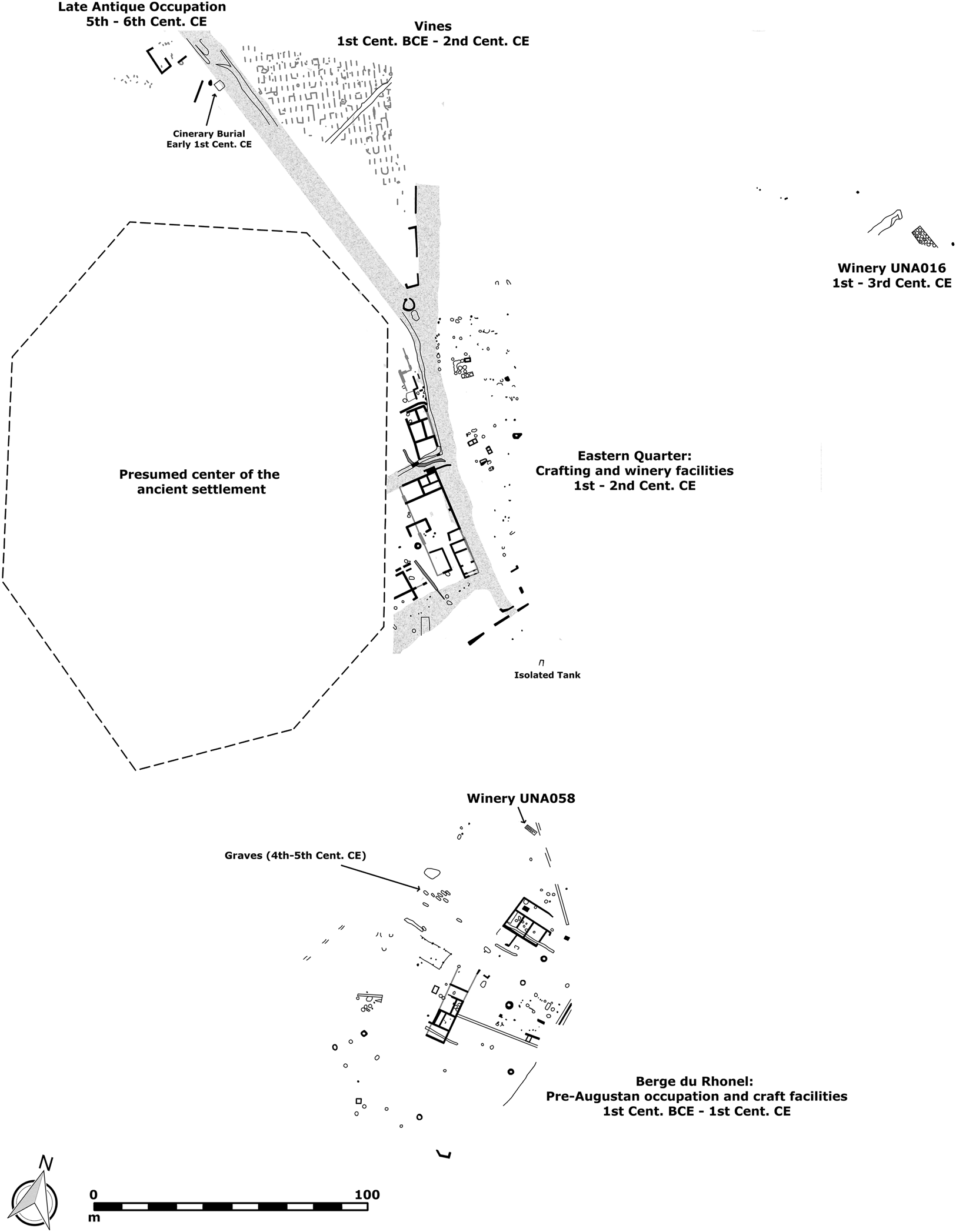
Around the beginning of the 1st c. CE, Q. Iulius Priscus, an Italian, probably from Puteoli, relocated to the province of Gallia Narbonensis, where he established an estate ex novo dedicated to wine production along the Dourbie River (Fig. 1).Footnote 2 Activity commenced with the construction of several kilns that produced ceramic building materials and dolia necessary to build the villa and its production spaces, along with housing for the potters and vineyard workers.Footnote 3 Some 75–150 ha of vineyards were planted. Within 10 years, a large (50 x 50 m) villa structure had been constructed, three sides of which were devoted to wine production: the central wing housed four lever presses, and the eastern and western wings were wine cellars, each holding 140–150 dolia of 14/15 hl capacity for a total of some 4,500 hl.Footnote 4 Ceramic production remained part of the villa's economic life, and Italian and Gaulish potters produced sigillata and finewares “à pâte claire” during the first half of the 1st c. CE.Footnote 5 Potters produced amphorae to bottle the wine, initially in imitation forms of the Spanish Pascual 1 and Italian Dressel 2–4, but then transitioning to new flat-bottomed forms, the Gauloise 1 and 2, during the 20s–40s CE. By the final quarter of the 1st c. CE, four kilns produced the Gallic wine amphora par excellence, the Gauloise 4 (G4).Footnote 6
General plan of Saint-Bézard. (Adapted from Mauné et al. Reference Mauné, Tiago-Seoane, Pellegrino, Bourgeon, Carrato, Latournerie, Roux, Desbonnets and Corbeel2021, Fig. 1; drawing by J. Page.)

Priscus's estate is one of the earliest examples of the investment in specialized viticulture that became characteristic of rural producers across Gallia Narbonensis over the first three centuries CE (Fig. 2). It is representative not only of one of the most successful aspects of the Narbonensian economy, but also of the colonial roots of this success. Wine, as has been so lucidly demonstrated by Dietler, was entangled with colonial encounters from its very introduction into Gaul by the Etruscans in the 7th c. BCE and continued to be so for centuries.Footnote 7 Priscus himself was just one of the many Italians who settled in Narbonensis in the wake of violent Roman conquest that fundamentally altered social and economic life in Gaul.
Gallia Narbonensis with selected wineries and cities. (Author.)

The extent and scale of Gallo-Roman viticulture has been well established through detailed excavation and multidisciplinary study of wine-producing farms and villas by French archaeologists in both academic and preventative sectors, making this region ideal for a study of specialized agricultural production.Footnote 8 Evidence from small farms to sprawling villas suggests that specialized productive strategies, while most obvious amongst the elites, were not limited to this class, but stretched across multiple strata of society as investment grew in what is often described as viticulture spéculative.Footnote 9 The very existence of specialized production, particularly at the scale at which it is documented in Narbonensis, requires significant demand, well-connected and integrated markets, sustained trade, and an awareness of these economic factors among the residents. As such, this evidence speaks to many ongoing debates about the Roman economy.
This paper explores the processes of specialized viticulture in the province of Gallia Narbonensis and brings this evidence to bear on broader economic questions, particularly as they relate to the effects of connectivity and globalization on Roman economic development and the nature of agricultural production as it differed between smallholders and elites. These questions are inherently social. While it is far from straightforward to move from quantifications of productive infrastructure to the numbers of people involved, much less to discussions about quality of life, human agency must be considered. Roman colonization stimulated the development and success of widespread viticulture in Narbonensis, and the effects of conquest, from the trauma of warfare to the social changes brought about by new colonists and centuriation schemes, on the native inhabitants should not be underestimated.Footnote 10 To understand the place of viticulture in Narbonensis we must be aware of threads of violence, asymmetrical power dynamics, and inequalities, as well as the ways in which these were resisted and even overcome. As Fernández-Götz, Maschek, and Roymans conclude a recent debate piece on Roman expansionism: “A holistic history should include winners and losers, and all those who cannot be easily assigned to one of these two poles and simply tried to adapt as best as they could to the changing world in which they lived.”Footnote 11 As will be argued below, viticulture developed as it did only because of the many Gallo-Roman inhabitants who shaped it over the course of many generations, creating opportunities for economic prosperity that reached eventually beyond the elites and colonial settlers.
Regional specialization and the Roman economy
Recognizing the motivations for and outcomes of agricultural specialization has important consequences for how we view the Roman economy; specialization reflects the economic effects of connectivity and globalization, particularly when examined at a regional scale. For the purposes of this article, specialization is defined as the focused production of certain commodities for export at the expense of more diversified production. Agricultural specialization can occur at individual or isolated scales (e.g., a single estate), but its existence on a regional scale – when multiple producers across a region choose to focus on the production of the same product – speaks to broader economic systems. While specialized production strategies are more profitable, they are also riskier. As a form of intensification that involves the reallocation of productive resources towards a particular crop or productive strategy, it requires regular and sustained trade and can only be understood within its broader socio-economic context.Footnote 12 It is important to stress that specialization does not equal monoculture, and that its economic benefits do not hinge on complete specialization in a single product.Footnote 13 Successful specialization brings increased overall efficiency through the division of labor and reduced opportunity costs, allowing for a greater output of production. Specializing in the production of goods for which one has an economic advantage therefore leads to greater gains in trade. Economies of scale, both internal and external, are highly relevant for specialized production strategies.Footnote 14 Internal economies of scale are particularly applicable for individual, large estates with substantial capital investment, while external scale economies come with the regional uptake of specialization as, for example, widespread investments in infrastructure improve trading processes and reduce transaction costs.
Studies of economic specialization in the Roman period are often centered on the urban sphere and craft production, with a particular focus on individual specialization through the horizontal specialization of artisans and traders or the vertical specialization of tasks within the production process.Footnote 15 While there are numerous archaeological studies of specialized regional production in the rural sphere,Footnote 16 the context and significance of such production are rarely explored fully in broader economic studies.Footnote 17
This gap is somewhat surprising given the recent rise in scholarship on the ancient economy, connectivity, and globalization.Footnote 18 Indeed, while scholars continue to debate numerous aspects of the nature and scale of Roman economic life, it is widely acknowledged that the Roman Mediterranean was characterized by remarkable levels of connectivity. While importing items which a region did not possess, or could not easily produce, had become common long before the Roman period, the exchange of trade goods that could be relatively easily produced across multiple regions involved in the exchange is one of the defining features of Roman trade. In light of increasingly detailed and nuanced studies of pre-Industrial markets, few scholars would now follow Finley, heavily influenced by the work of Polanyi, in rejecting market exchange in the ancient world.Footnote 19 Integrated markets, a prerequisite for successful specialized production, are now widely recognized in Roman economic studies and most debates concern the extent of integration amongst markets rather than their existence.Footnote 20 Market integration was, of course, far from uniform, and levels of integration varied substantially, both geographically and chronologically. Integration, as with connectivity or globalization, should not be thought of as an either/or matter, but as a process that occurred along a spectrum with significant geographical and chronological variation across local, regional, and empire-wide scales. We should expect diversity; the spheres of connectivity and integration in 1st-c. CE Narbonensis were not the same as those of Asia in the 1st c. CE nor the same as Narbonensis in the 3rd c. CE. Understanding the diversity inherent across regional patterns of economic integration provides a better understanding of not only the particulars of local and regional economies, but those of the Roman world as whole.
An increasing number of scholars recognize that specialized production, while inherently riskier than diversified production, occurred in situations where the degree of market integration provided sufficient security. Erdkamp, for example, emphasizes the importance of market integration for reducing the risks inherent in specialization, arguing against specialization in the grain trade both because diversification was the best protection against risk and because the market for grain was poorly integrated. He does, however, argue for more specialization and a higher degree of market integration for vine and olive crops.Footnote 21 The often prevailing view remains that the security offered by diversified crop production would have outweighed the economic benefits of specialization, particularly if one were not a part of the landowning elite.Footnote 22 Poblome, who himself discusses examples of agricultural specialization, sums up this view for Sagalassos: “Unlike in capitalist societies, however, the farming strategy remained traditional and aimed at minimum risk and maximum options of survival. Having a little of everything was considered better than profit-seeking.”Footnote 23 Pleket highlights several examples of agricultural specialization, but ultimately argues that diversified production remained the standard because of the inherent vulnerabilities of ancient agriculture.Footnote 24
For others, integrated markets existed, but specialized production is dismissed as economically insignificant in light of the ubiquitous nature of Mediterranean resources. Morley, for example, considers that there was a “significant increase in inter-regional economic activity, and a degree of integration between local and regional economies” in the Roman period, but that there was a “relative ubiquity of most of the key raw materials of production” and that “objects of exchange were for the most part too generic, too easily imitated or substituted to sustain anything other than a short-term advantage for a particular region's products (e.g. Italian wine and olive oil initially dominating in the West and then being supplanted by Gallic, Spanish and African products)” (emphasis added).Footnote 25 Witcher too highlights the significant scale and extent of Roman exchange, but downplays the possibilities of specialization: “there was limited scope for the development of regional specialization and mass consumption. Around the Mediterranean, no region had a particular advantage in terms of basic resources” (emphasis added).Footnote 26 Morley and Witcher's comments are written specifically within a consideration of globalization, a scale at which raw materials and products such as grapes, olives, and clay were indeed widespread. Specialization in such products did occur, however, and was often sustained for multiple generations, speaking to a complexity of economic life that needs to be better understood.
The general unease with agricultural specialization can, in part, be attributed to an often-subconscious reliance on several problematic frameworks and dichotomies, including lingering notions of Mediterranean homogeneity, idealized autarky, and an uneven application of economic theory. There is also a strong need for more detailed archaeological studies that engage with economic questions on meaningful scales.Footnote 27 More contextualized discussions of the archaeology of agricultural production at a regional level can aid in bridging the disconnect between recognizing the existence of connectivity and exploring its economic significance and contribute to better understandings of the economic effects of connectivity and globalization.
Adjusting our frameworks
Ideas of Mediterranean sameness continue to persist, despite ample evidence and scholarship to the contrary. While frequently recurring geologies and climatic patterns across the Mediterranean led to the eponymous climate type, the Mediterranean is also characterized by the strong variability of landscapes within its microregions.Footnote 28 This is not, of course, to deny very real commonalities across the Mediterranean, but to emphasize that even within broadly comparable landscapes, lived realities could differ. As has been emphasized so compellingly by Horden and Purcell, the myriad range of microregions and the fragmented topography of the Mediterranean directly necessitated connectivity.Footnote 29
This discussion is bound up with another lingering ideology: autarky, and the conflation of ancient rhetoric surrounding self-sufficiency with actual practice.Footnote 30 Scholarship has tilted towards the recognition that self-sufficiency was more ideological than obtainable, though not all would go as far as Horden and Purcell's uncompromising argument that, “to aim at subsistence is suicidal.”Footnote 31 Nevertheless, the notion of self-sufficiency continues to influence scholarship, particularly with regard to the agricultural priorities of peasants, and reinforces unconstructive dichotomies between production strategies aimed at self-sufficiency versus market integration, and risk-mitigation versus profit-seeking.Footnote 32
It is also crucial to understand that while Mediterranean diversity and unevenly distributed resources necessitated connectivity and exchange, trade is not dictated wholly by the simple presence or absence of resources. Many scholars of the ancient economy continue to focus primarily on the Smithian concept of absolute advantage, that is, the principle that trade becomes beneficial when an entity (individual, nation, region, etc.) specializes in the production of goods that they can produce with absolute efficiency and trades these surplus products with entities specializing in other products.Footnote 33 Trade theory, however, has not hinged solely on absolute advantage since Ricardo introduced the theory of comparative advantage in 1817.Footnote 34 Some trade in the Roman world was, of course, profitable by way of an absolute advantage, but a wholesale reliance on absolute advantage as an explanatory factor restricts analyses not just of production and raw materials, but also of technology and labor. Writing about the involvement of “peasants” in the market, Silver clearly identifies the problem: “Objections…fail to understand that specialization and trade are guided by comparative, not absolute advantage. What matters is not a difference between trading partners in the amount of productive resources required to produce a good, but rather a difference between them in the rate at which one good can be transformed into the other by reallocating resources.”Footnote 35
Economics
A more nuanced understanding of economic theory, particularly international trade theory, can illuminate paths forward. The point here is not to suggest that the Roman economy was a modern one – it was not – yet modern models of trade and economic development provide a framework through which ancient patterns can be analyzed and better understood.
The problems with an overreliance on absolute advantage have already been discussed above, but there are alternatives. The theory of comparative advantage, particularly as refined over the past 200 years, remains today as one of the fundamental explanations of trade.Footnote 36 Concisely put, a comparative advantage may be gained when an individual, region, or nation can produce a good with a lower relative or opportunity cost when compared to other potential production locations,Footnote 37 and trade becomes mutually beneficial when it occurs between two regions with a comparative advantage in different products. Differences in production costs between trading partners are still required to gain a comparative advantage. For Ricardo, these differences came through technology, but the neoclassical Hesckscher-Ohlin theory expanded this to consider production costs as bundles of the factor endowments of land, labor, and capital.Footnote 38 The importance of this principle lies with the consideration that the differences in production costs can be relative, often expressed in terms of opportunity costs, or what is lost. Even if a region cannot obtain an absolute advantage in a product, they can gain a comparative advantage by specializing in the production of their least inefficient products and therefore trade will still be beneficial. Indeed, economic historians such as Temin and Silver have been urging ancient historians to engage (correctly) with the theory of comparative advantage, though few have taken up the call.Footnote 39
It is also worth considering the more recent theoretical approaches of economic geography and “new trade theory” that gained Paul Krugman the 2008 Nobel Prize in Economics. These approaches developed to explain the marked rise in trade in similar products between similar countries that occurred after World War II, a type of trade that was not explainable by the difference-driven comparative advantage. New trade theory focuses on intra-industry trade (the simultaneous import and export of the same or similar goods). Building on work on economies of scale by Ohlin and others, Krugman explained the specialization within intra-industry trade in terms of the exploitation of scale economies linked with consumer demand for variety.Footnote 40 This explanation is not mutually exclusive from that of comparative advantage, and work on international trade now frequently incorporates both “old” and “new” trade theory.Footnote 41
Prior to the introduction of the “new economic geography” in 1991, trade theory focused largely on factor proportions (land, labor, capital) or technology, with little consideration of the geography of production.Footnote 42 Economic geography to this point was a nebulous area of spatial economics and location theory that sought to incorporate spatial dimensions into the study of production factors. Research in these areas, such as that by Marshall on agglomerations and economies of scale, was rarely integrated into international trade economics.Footnote 43 Krugman's work drew on earlier traditions of spatial economies to create the space for new models that engaged specifically with trade theory through the geographical location of production. Transport costs, for example, are a key component of new economic geography. New economic geography therefore provides insights into the existence and potential success of clustered production centers or agglomerations. Two key points are worth mentioning here. First, production clusters, even those located at some distance from their markets, can be explained by economies of scale (both internal and external). Such clusters are sustainable and profitable if the economies of scale are sufficiently high relative to transport costs. Secondly, the actual location of the concentration of production can be due to historical chance, rather than well-considered planning.Footnote 44
As is evident from this very brief overview, production lies at the center of trade theory. Much of the archaeological evidence frequently invoked in discussions of the economic effects of connectivity and globalization is typically related to documenting connectivity through the consumption of imports, but trade cannot be understood by focusing on imports alone. Evidence from the productive sphere has significant potential to deepen our understanding of the ways in which the inhabitants of the Roman world chose to engage with and respond to the opportunities afforded by connectivity. Decisions regarding production involve substantial considerations of risk and investment. Deciding what to produce – or perhaps even more importantly in some cases, what not to produce – has long and lasting implications for one's livelihood, particularly when this requires investments of capital infrastructure (e.g., pressing equipment) or time (e.g., waiting for olives or vines to mature), and intentionally involves movement away from autarkic production strategies. Such decisions speak to a level of investment in economic life beyond one's ability to choose from a variety of wines or tablewares. With this, let us return to Gallia Narbonensis.
Gallia Narbonensis
The landscapes of Gallia Narbonensis are diverse (Fig. 2), encompassing the marshy lagoons of Occitanie, the large alluvial plain of the Camargue delta at the mouth of the Rhône River, mountainous stretches of Provence Alpes-Cote d'Azur, and arable plains between the sea and the Montagne Noire and Cévennes mountain ranges of the Massif Central to the north. It is worth noting here that Gallia Narbonensis, while a political region, consisted of several ecological microregions. The wine production that is the subject of this paper is not evenly distributed across the entire province, but it does occur in multiple clusters across multiple microregions within the province, for example, the Rhône and Hérault valleys, and around Fréjus. As this paper explores inter-regional trade, the term “region” is used to refer to the province, encompassing these microregions. The Rhône River was a defining feature of the province and critically influenced its development in the Roman period as a major connective waterway linking Mediterranean regions with those of the northern provinces. Wine, oil, and grain can all be produced within Narbonensis; the lack of production of one or more of these staple crops therefore cannot be attributed to an environmental cause, making the region an ideal case study for assessing agricultural specialization.
Rome conquered this territory, which they first called Gallia Transalpina, in 121 BCE after some three years of military operations. In 118 BCE, Rome founded its first colony, Narbo Martius, settled by civilians, and constructed its first road in the region, the via Domitia. A governor was installed, and military garrisons were established at Aix-en-Provence and Toulouse. Italians relocated in seemingly substantial numbers.Footnote 45 As early as 69 BCE, Cicero could argue (while defending Fonteius, former governor of Gaul, from charges of financial corruption brought against him by the Gauls) that, “Gaul is crowded with traders (negotiatores), full of Roman citizens. None of the Gauls conduct any business whatsoever without a citizen of Rome; no coin is exchanged in Gaul without being recorded in the account books of Roman citizens.”Footnote 46 Rural settlement intensified across Narbonensis in the aftermath of Roman colonization and the establishment of the colony of Narbo Martius, and then more extensively after Caesar's Gallic Wars. Some, though certainly not all, was due to the settlement of veterans in newly centuriated landscapes.Footnote 47 Augustus renamed the province Gallia Narbonensis, probably in 27 BCE as part of larger interventions in Gaul. At this point, five veteran colonies had been established in Narbonensis: Arles and Narbonne were founded and re-founded under Caesar for veterans of the Sixth and Tenth Legions, and Béziers, Fréjus, and Orange under Octavian for veterans of the Seventh, Eighth, and Second Legions respectively. By the late 1st c. CE, Pliny described Gaul as a place that “in the cultivation of the soil, the manners and ways of the men, and the extent of its wealth… is surpassed by none of the provinces, and, in short, might be more truthfully described as a part of Italy than as a province.”Footnote 48
Throughout Narbonensis, there is plentiful evidence for a range of rural economic activities, though at substantially variable scales. The importance of grain is strikingly illustrated not only by the well-known 2nd-c. CE hydraulic grain mill at Barbegal, but by the widespread presence of watermills at rural sites across Gaul, demonstrating the on-site production of flour, from both local and imported grain, often for local consumption in high quantities.Footnote 49 This was an important technological advancement beyond hand- or animal-powered mills, increasing efficiency and decreasing labor in the production process.
Significant evidence of Roman pastoralism has been found to the southwest of Arles on the plains of the Crau, where survey and excavation have revealed some 80 sheep pens dating to primarily the 1st and 2nd c. CE.Footnote 50 Faunal analysis from some of the pens suggests that the ovicaprines were being raised for wool and probably milk and cheese, but not for meat.Footnote 51 A corporation of centonarii – wool merchants – is known from Arles, and a relief sculpture found in the vicinity shows two men preparing a large bale of wool for transport, further suggesting the importance of wool to Arles's economy.Footnote 52
Natural resources were exploited widely. The Montagne Noire contained iron, lead, and silver, the Cévennes deposits of silver, lead, and copper, and copper, iron, and lead were found in the Maures Massif.Footnote 53 Basalt quarried at Embonne near Cap d'Agde was exported, largely for millstones.Footnote 54 Limestone was quarried for building, and timber was used for a range of industries. Pitch production, linked closely to the wine industry through the lining of dolia and amphorae, is difficult to document, but nonetheless attested at several locations including the pine forests of the Causses Méjean and the Sauveterre, where some 30 pitch production stations have been identified.Footnote 55
Craft production is clearly visible in urban settings, particularly evidenced by the rich epigraphic corpus of cities such as Narbonne where, amongst other crafts, those related to textiles, leather working, and metallurgy are prominently attested.Footnote 56 Excavations at Toulon revealed remnants of various artisanal crafts including wood shavings, pieces of leather, and discarded pieces of worked bone, as well as the only known evidence of murex production along the French coast.Footnote 57 Outside the cities, the substantial and well-known production of Gallic sigillata, such as that produced at La Graufesenque from roughly 20–120 CE, clearly occupied a major place in the economic life of the province.Footnote 58
To turn to the sea, vivaria for the keeping of live fish have been documented,Footnote 59 as have tanks for salt production.Footnote 60 Salted fish production occurred, concentrated largely between ancient Fréjus and Nice, and kilns producing amphorae for salted-fish production are known from Fréjus (Dressel 14)Footnote 61 and Cannes (Dressel 16).Footnote 62 At Lattes, the excavation of a well has revealed thousands of fish bones, the majority from sardines, and it has been suggested that this is the refuse from garum production.Footnote 63 Ceramic assemblages from across the region indicate that salted-fish products were also frequently imported from Spain.Footnote 64
In short, there is good evidence for a diverse range of economic activities at a multitude of scales: sigillata was produced at a large, export-oriented scale; salted-fish products were produced for supra-regional export within a small locale. Other economic activities were widespread but aimed at serving local or intra-provincial needs. What about the standard cash-crops of oil and wine?
Olive oil?
While much of Narbonensis is well suited to olive cultivation, the Roman period saw only minimal investment in its production.Footnote 65 Archaeological and palaeo-environmental evidence indicates that it was not until the Middle Ages that Narbonensis became a major producer of olive products.Footnote 66 The majority of Roman oil production occurred in the Var region, and even there we see only some 30 olive mills as compared with 164 remains of wine presses.Footnote 67 Most of the oil-producing sites also produced wine. Even the Gallo-Roman villa of Saint-Michel à La Garde (Var), with six presses and six basins, all of which were originally thought to be for oil production, making it the largest oil-producing villa in Narbonensis, has now been shown to have produced wine alongside oil.Footnote 68
Where, then, did the residents of Narbonensis obtain their olive oil? To answer this question, we turn to proxy evidence in the form of amphorae. From the 1st c. CE, assemblages across Narbonensis reveal that Baetican oil (identified by proxy through Dressel 20 amphorae) was widely consumed. Baetican olive oil is perhaps the most well-known example of specialized regional production, due to the overwhelming evidence from investigations into the stamps and tituli picti of the Dressel 20 amphorae from Monte Testaccio in Rome and frontier forts.Footnote 69 Figure 3 maps the distribution of Dressel 20 stamps from the CEIPAC database.Footnote 70 As this is only stamped material, it is a significant underrepresentation of the actual number of Dressel 20s, but the distribution of even the minimum number is sufficient to illustrate the substantial amount of Baetican oil consumed throughout Gaul. As expected, coastal deposits reveal particularly high percentages of Dressel 20s both in areas of consumption and in transshipment areas such as the mouth of the Rhône, as do deposits along the Rhône such as those at Vienne and Lyon.Footnote 71 They were hardly limited to these areas, however. While not clear from stamps alone, Dressel 20s were prominent in northwestern Gaul, with large numbers found in Rouen, Amiens, and Bavay.Footnote 72 They are present across all types of sites, including both rural and urban domestic assemblages such as those from the Clos de la Lombarde in Narbonne to the Gallo-Roman villa at Gourjade à Castres (Tarn), located over 100 km inland from Narbonne, where they were the most common type of amphorae.Footnote 73 Roadside inns in the Hérault Valley, such as those at Pétout (Le Bosc), Soumaltre (Aspiran), and Quintarié (Clermont-l'Hérault), have large numbers of Dressel 20s, and Mauné has suggested that they served as important collection and distribution points of Baetican oil throughout the countryside.Footnote 74 A single Dressel 20 holds some 60–70 liters of olive oil, more than a small household could consume before the oil went rancid, and one can easily imagine inns reselling the oil in smaller quantities.
Distribution and heatmap of Dressel 20 stamps. (Author, data from https://romanopendata.eu/#!/.)

The point is clear from both the lack of oil production sites and the amphorae finds: most olive oil consumed in Narbonensis originated from Baetica. To explain this dependence, we should consider the nature of opportunity costs.
The intricacies of Baetican olive oil production and subsequent distribution in Dressel 20 amphorae are well discussed and only a very brief review is needed here. The production of Baetican olive oil, which reached its peak between the 1st and 3rd c. CE, was concentrated in the Guadalquivir Valley. Over 70 Dressel 20 kilns are known, though far fewer oil production sites have been found.Footnote 75 It is widely agreed that the markets of Rome and the northwestern provinces were largely responsible for the specialization of olive oil production in Baetica, though the mechanisms of the oil distribution are debated. Remesal Rodríguez's view that Baetican olive oil was distributed to Rome and the military through state-controlled measures has been taken up by many, though it has been strongly and convincingly argued against by Wierschowski and others who highlight the role of the free market in the oil's distribution.Footnote 76
Vast amounts of olive oil in Dressel 20s had arrived in the ports of Narbonensis by the beginning of the 1st c. CE; while much was aimed at the new markets of northern Gaul and Germany, the widespread distribution throughout Gaul clearly shows the importance of these markets as well. This permeation of Dressel 20s has been noted and discussed by archaeologists of rural GaulFootnote 77 but is otherwise often overlooked due to the overwhelming scholarly focus on Rome and the military. This is a considerable oversight as the widespread distribution and high concentrations of Dressel 20 amphorae across Gaul are integral to our understanding of agricultural production within Narbonensis. The limited oil production in Narbonensis should be viewed as an intentional economic decision. The residents of Narbonensis had no reason to compete for a market share as they were unlikely to obtain any economic advantage in the production of olive oil given the dominance of Baetica in this area.Footnote 78 While some continued to produce oil on relatively modest scales, most of the region consumed Baetican oil, focusing its resources on a product for which there was a place in the market and for which they could obtain an economic advantage – wine. In the early Empire, most Mediterranean regions had an absolute advantage in wine and oil when trading with the northern provinces, regions where olives do not grow and where vines had not yet been introduced on a substantial scale. The advantages that led Baetica to specialize in olive oil and Narbonensis in wine production were, however, comparative ones.
Gallic wine
It is worth noting that the story of Roman wine in Gaul begins before the Roman conquest. Gaul was a major consumer of Italian wine from the end of the 3rd c. BCE. Greco-Italic and Dressel 1 amphorae have been found in the hundreds of thousands throughout France, especially in Late Iron Age oppida.Footnote 79 While the scale of the trade is undeniable, the nature of the trade is less evident. Tchernia, Poux, Fentress, and others view the trade as linked with Gallic elites and slaves.Footnote 80 Poux regards the distribution of amphorae as an indicator of potlatches and associates numerous amphorae deposits with ceremonial sites where amphorae were “sacrificed” at feasts.Footnote 81 Fentress has hypothesized that the potlatches were linked with the slave trade and that the ritual practice of “sacrificing” the wine amphorae with their blood-red contents was directly related to slave raiding. The more slaves that a tribe could acquire and sell, the more wine could be consumed at the potlatch.Footnote 82 Several historical sources reference the Gallic slave trade, most famously Diodorus Siculus, who records that the Gauls would exchange one slave for an amphora of wine.Footnote 83 The quantities of Italian wine amphorae in Gaul drastically declined around the middle of the 1st c. BCE and had nearly ceased by 30 BCE. It has been suggested that this decline is associated with the collapse of Italian viticulture, or the change from amphorae to barrels,Footnote 84 but the link between the wine trade and slaving provides a much more credible reason for the cessation of the trade. As highlighted by Tchernia and Fentress, Caesar's conquest of Gaul would have destroyed the source of slaves, as slaving within the bounds of Roman territory was unacceptable.Footnote 85 The continued importation of Italian wine into pre-conquest Britain suggests that the trade simply moved north until the Claudian conquest.Footnote 86 By 30 BCE, wine imported from Tarraconensis had largely replaced Italian wine, and Narbonensian production intensified.Footnote 87 Wine was always imported from beyond the province to satisfy the demand for variety, but Narbonensian wine soon satisfied everyday needs.
Viticulture had been practiced on a limited scale in southern Gaul for centuries prior to Roman colonization. Production had largely centered around Marseille, where Phocean Greek colonists planted vines after establishing Gaul's first colony at Massalia around 600 BCE. Massalian wine was exported across southern Gaul and was the most widely consumed wine in the region until the 2nd c. BCE, when it was largely replaced by Italian wine. Vines were otherwise rare, with a few notable exceptions, such as those identified around Lattes from the late 3rd c. BCE.Footnote 88 From the end of the 1st c. BCE, viticulture expanded rapidly, characterized by stone-built pressing infrastructure, installations with multiple presses, and substantial purpose-built fermentation and storage facilities with dolia.Footnote 89 Wineries became progressively larger in scale over the 1st c. CE, and several exceptionally large production sites are known, but these large wineries existed alongside many small farms with purpose-built wine infrastructure.Footnote 90 Wineries began to be abandoned at the end of the 2nd/early 3rd c. CE for reasons not yet entirely understood. While production did seem to continue to some degree, it was on a much smaller scale with few dolia fermenting structures and pressing elements.
Carrato's study of wine production installations with storage facilities in Narbonensis from the 1st c. BCE to the 5th c. CE illustrates the rise and fall of large-scale viticulture (see Supplementary Table 1).Footnote 91 She collected data on 66 wine storage facilities, mostly warehouses with dolia – cella vinaria (62 sites) – though also some with barrels (4 sites). The construction of wine storage facilities increased rapidly during the first half of the 1st c. CE and peaked in the latter half of the 1st c. CE. New construction dropped off by the 2nd c. CE, but the overall volume of active storage was at its highest from the mid-1st c. CE through to the end of the 2nd c. CE. At least 53 wine storage facilities are known from the mid-1st c. CE, with a combined total storage capacity of some 76,000–80,000 hl maintained from the mid-1st through the end of the 2nd c. CE.Footnote 92
The largest of the wineries are characterized by multiple presses and massive dolia warehouses, some 13 of which contained over 100 dolia. Figure 4 shows these warehouses scaled by the number of dolia. These are the most well-known wine-production sites and clearly illustrate elite interest in viticulture due to the massive capital costs needed to construct and maintain these facilities.Footnote 93 While united by the eventual scale of their production, even these largest wineries develop along varying trajectories.
Evidence for viticultural establishments including dolia warehouses, scaled by the number of dolia, and G4 amphorae kilns. (Author, data from Carrato 2017 and Carrato 2020.)

The extensive villa and kiln complex at Saint-Bézard (Aspiran, Hérault) with which this article opened was constructed explicitly to specialize in large-scale viticulture, and the extent of this production has already been noted (Fig. 1). The site changed and expanded over time – a small cellar with some 12 dolia was added to the courtyard around 30 CE and an aqueduct and natatio, along with a tower containing a small bath and kitchen/bakery, were added in the Flavian period – but the productive focus of the villa remained the viticulture for which it was founded and which continued until the end of the 3rd c. CE.Footnote 94
The massive wineries at Toulons (Rians, Var) and Molard (Donzère, Drôme) were both installed in a single phase in the mid–late 1st c. CE. At Toulons, a U-shaped cellar held an estimated 250 sunken dolia, each with an average capacity of 15 hl, creating a potential storage capacity of over 3,000 hl. There were two pressing rooms, located at the ends of the eastern and western wings of the cellar, each of which contained two lever presses and two large vats.Footnote 95 At Molard, a single rectangular cellar held some 204 large dolia (23–24 hl capacity) for a potential capacity around 4,600–4,800 hl.Footnote 96 Similarly, the Gallo-Roman villa of Pardigon 3 (Cavalaire-sur-Mer) was constructed ex novo to produce wine for export; the estimated capacity of its dolia cellar is 1,100–2,000 hl (from an estimated 139 dolia).Footnote 97
At Vareilles (Paulhan, Hérault), a small farm of the 1st c. BCE was enlarged over the course of the late 1st c. BCE and early 1st c. CE to a large productive estate with an aqueduct and evidence of wine, oil, and perhaps grain production (Fig. 5).Footnote 98 Around the middle of the 1st c. CE, the space was re-organized and devoted entirely to wine production. A large (3,600 m2) U-shaped structure was built, two wings of which were wine cellars with up to 350 sunken dolia. Artisanal buildings and a water mill were constructed adjacent to the main courtyard. This re-organization also extended to the vineyards themselves, which were moved to make room for the U-shaped structure, expanded, and planted at an increased density of some 4,500–5,000 plants/ha. An additional wine cellar and water mill were added to the villa around 70 CE, and additions were made to the pars urbana, including a bath complex and monumental foundation. Two additional wine cellars were added in the early 2nd c. CE, and the two earlier water mills were replaced by a bigger one. This was the largest phase; the buildings extended over an area of 12,000 m2, the vineyards for an estimated 115–142 ha, and the four cellars housed a total of 477 dolia for a storage capacity between 6,855 and 8,586 hl.Footnote 99 Estimates suggest that the vineyards would have required a dedicated workforce of at least 50 people. After several generations of successive growth, the villa was largely abandoned over the latter half of the 2nd c. CE.
Plan of Vareilles Phases 2 and 3. (Adapted from Mauné Reference Mauné2003, Figs. 7 and 8; drawings by J. Page.)

The trajectory is illustrative. What began as a small farm with wine and oil production was expanded to focus on large-scale wine production for export, though the wine production did not occur at the expense of all productive activities. The water mills indicate the production of flour for the residents and workers of the villa. There is also evidence of a fruit orchard, particularly in the 2nd c. CE, and livestock breeding. Wool production is attested in the villa's artisanal area and perhaps also implies sheep breeding. A workshop for metal working (iron, lead, and bronze) provided necessary equipment for a large estate. The wine production did, however, occur at the expense of olive oil, which was produced only in the second phase of the late 1st c. BCE.Footnote 100
The villa of Prés-Bas (Loupian, Hérault), located on the shores of the Étang du Thau, was also transformed from a small farm in the 1st c. BCE into a villa with an elite residential zone and large production area by the 1st c. CE. Its winery was extensive, measuring approximately 315 m2 with some 90 dolia and an estimated capacity of 1,500 + 250 hl.Footnote 101 The villa was also associated with a kiln producing G4 amphorae, some of which were stamped “MAF”, hypothesized to be the initials of the tria nomina of the villa owner.
The villa Régine (Quartier Régine, Puy-Sainte-Réparade, Bouches-du-Rhône) was also initially a small farm, perhaps producing wine by the early 1st c. CE.Footnote 102 Around the late 1st/early 2nd c. CE, a large U-shaped winery (450 m2) was constructed with a double press and cellar with around 80 dolia and an estimated capacity of 800–1,200 hl. The winery was further enlarged with the addition of another press in a building adjacent to the earlier winery, and the presses were converted from lever presses to screw presses, perhaps during the mid-to-late 2nd c. CE.Footnote 103 Interestingly, it seems that it is only after the winery reached its largest extent that an elaborate domestic area was added to the site, suggesting that it was converted into a villa by the early 3rd c. CE. The winery remained active until much of the site was abandoned and partially deconstructed around the mid-3rd c. CE, but faunal remains suggest that cattle breeding became important from the early 3rd c. CE as wine production was decreasing.Footnote 104 The site was fully abandoned by the mid-4th c. CE.
Similar trends can also be seen at smaller sites, such as Gasquinoy (Béziers, Hérault) (Fig. 6). The site consists of two farms, occupied during the 1st and 2nd c. CE, each with a well and wine-making areas, surrounded by both vine-planting pits and trenches. Farm A's structure was approximately 750 m2 and contained a vat, press foundation, and two storage rooms with 27 dolia (estimated capacity 400–500 hl), as well as a structure seemingly for grain storage. Farm B had a slightly larger structure (800 m2) with two areas containing remains of wine-production equipment, one near the courtyard of the farm with a vat and a room with 12 dolia (capacity 200 hl), and a second to the north of the farm building with a vat and a single dolium. The vineyard is estimated at 15 ha, a size that is in line with those of nearby farms, which seem to average between 10 and 30 ha of farmland each.Footnote 105 Archaeobotanical studies from the two farms confirm the predominance of vines and suggest limited production of grain and fruit trees.Footnote 106 Both farms were abandoned by the end of the 2nd /early 3rd c. CE.
Plans of Gasquinoy A, Gasquinoy B, and Renaussas to scale. (Adapted from Figueiral et al. Reference Figueiral, Bouby, Buffat, Petitot and Terral2010, Fig. 2 and Figueiral et al. Reference Figueiral, Jung, Martin, Tardy, Compan, Pallier, Pomarèdes, Fabre, Delhon, Théry-Parisot and Thiébault2009, Fig. 2; drawings by J. Page.)

The farm at Renaussas (Valros, Hérault) was of a comparable scale to that of Gasquinoy A at the time of its establishment in the 1st c. CE, though it expanded significantly in the 2nd c. CE. The vineyards were initially planted with trenches spaced approximately 4 m apart, presumably to allow for polyculture, but densified in two subsequent stages by placing additional vine trenches between the original trenches, removing the option of intercropping but creating a higher density of vines.Footnote 107 The wine cellar, located in the center of the small farm building, contained both dolia and barrels. The storage capacity is expanded as well, from 12 dolia in the 1st c. to 18 dolia in the 2nd c. CE, with barrels alongside in both phases. Barrels were, in fact, being produced on site, as suggested by finds of numerous woodworking tools and a branding iron. The branding iron, associated with material from the 2nd c. CE, suggests that the barrels were not only for storage but for exchange.Footnote 108
Much smaller vineyards, estimated at around 5–10 ha, associated often with a small press, vat, and a few dolia or barrels, were clustered around villages or secondary agglomerations, such as that of Peyre Plantade (Clermont-l'Hérault).Footnote 109 Seven small vineyards have been documented around Peyre Plantade (Fig. 7); the two largest had modest dolia storage, while the remains of a press coupled with a single or twin vat were recovered at three of the smaller sites, and two sites only had vats.Footnote 110 The village also contained artisanal quarters with a kiln and a smithy, along with a structure that was perhaps an inn. The exact nature of the settlement is unknown; it could have been a gathering point for autonomous small-scale artisans and farmers or connected with one or both large villas located in its vicinity.Footnote 111 Even if some activities related to an elite villa, it seems unlikely that this would extend to the wine production. It is possible that small-scale winegrowers were working collectively to organize and market their wine production, opening avenues for smallholders to participate in an industry that might otherwise have been beyond their reach.
Plan of Peyre Plantade. (Adapted from Pomarèdes et al. Reference Pomarèdes, Compan, Ginouvez and Jung2008, Fig. 7; drawings by J. Page.)
The small farm of Barresse (Muy, Var), occupied for no more than 100 years between the mid-2nd and mid-3rd c. CE, was also probably part of a small village.Footnote 112 The living quarters were modest, with earthen floors, and about half the structure was taken up by productive space including two small rooms for the production of cookwares and a series of rooms for wine production, including a press and a cellar with between six and ten dolia.
Within the few production sites discussed, we can see a variety of ways and scales at which the residents of Narbonensis engaged with the wine market. Q. Iulius Priscus perhaps relocated to Gaul with the aim of establishing a large wine-producing estate. Most of the large wineries constructed in a single phase were not built until after the mid-1st c. CE, at which point the demand was established. At other sites the decision is made to move from existing, more diversified production to more specialized wine production. This can be seen with the cessation of olive oil production at Vareilles and of intercropping at Renaussas. Similarly at La Lesse–Espagnac (Sauvian, Hérault), wine production seems to have expanded at the expense of arboriculture.Footnote 113 Risk was mitigated in a variety of other ways, including the planting of different species of grapes of both wild and domesticated varieties, and genetic evidence confirms that multiple varieties were grown within individual vineyards.Footnote 114 Often there is evidence for a gradual, but considerable scaling up of specialized wine production. As stressed above, specialization does not equal monoculture. These sites continued to engage in multiple productive activities while devoting the bulk of their resources towards wine production, a balance that has been referred to as “polyculture à dominante viticole.”Footnote 115
The scale of viticulture is further evidenced by the production of amphorae used to bottle and transport the wine.Footnote 116 Over 130 amphorae production sites are known from Narbonensis.Footnote 117 The earliest productions begin in the late 1st c. BCE, with imitation forms of Pascual 1, Dressel 1, and Dressel 2–4 amphorae, such as those discussed previously in connection with the villa at Saint-Bézard. Production expands with the development of a series of flat-bottomed Gauloise amphorae. The Gauloise 2 amphora is produced from around 40 BCE, but its production is more limited than subsequent types produced from the middle of the 1st c. CE such as the Gauloise 1 (largely west of Rhône) and Gauloise 5 (largely east of Rhône). The Gauloise 4 (G4) was produced specifically for export and was the most common form following its introduction around the 60s CE.Footnote 118 As of 2020, 61 workshops have been identified (Fig. 8).Footnote 119 Amphorae workshops were located across a variety of predominately rural site types, though occasionally clustered around cities. Some, but not all large wineries produced their own amphorae, and many workshops produced amphorae for multiple wine producers.
Location of Gauloise 4 kilns. (Author, data from Mauné Reference Mauné2013 and Bigot Reference Bigot2020.)

The market for Gallic wine
The intensification and specialization of production was, of course, driven by the demand for Gallic wine. The high volume of Gallic wine consumed is clearly illustrated through amphorae proxies. Within Narbonensis, early imported wines from Italy and Taraconnensis were most popular, but from the 1st c. CE, regionally produced wine increasingly dominates the market. The largest markets for Gallic wine outside Narbonensis were Rome, Ostia, northern Gaul, and Germany. Assemblages from the Rhine frontier, here taken from the RAAD database, a collection of published amphorae assemblages from 79 civilian and military sites in the province of Germania, illustrate this clearly.Footnote 120 While this is a sizable number of published assemblages, most were published without clear phasing, which makes it difficult to chart change over time in detail. There are, however, assemblages from 22 sites that were not occupied past the mid-1st c. CE and separating these out from the overall sample allows a view of wine imports pre- and post-G4. As mentioned, Gallic wine is exported prior to the G4 amphora, and we can see this in a few sites in Germania (e.g., Augst, Mainz, Xanten), but the large-scale export of Gallic wine occurs with the G4. Figure 9, a graph of amphorae from sites that date prior to the 60s CE, shows that most wine imported in amphorae was from the eastern Mediterranean (particularly Kos and Rhodes).Footnote 121 Shortly after G4 amphorae begin to be produced, Gallic wine imports increase and overwhelmingly dominate the wine market for the next two centuries (Fig. 10).
Wine imports by origin along Rhine Frontier before 60s CE. (Author, data from Franconi Reference Franconi2021.)

Wine imports by origin along Rhine Frontier after 60s CE. (Author, data from Franconi Reference Franconi2021).

Arles was a particularly integral node; it was the most southerly bridging point over the Rhône, and the canal of Marius safely connected Arles to the Mediterranean.Footnote 122 As such it was an ideal transshipment point for Gallic wine aimed at either northern or Mediterranean markets,Footnote 123 as well as Baetican olive oil and other Mediterranean products being shipped northwards along the Rhône-Rhine corridor to northern Gaul and Germany, along with products moving southwards down the Rhône for consumption in Narbonensis or elsewhere in the Mediterranean. While some ships were designed to travel on both the Mediterranean and rivers, most Mediterranean cargoes would have been transshipped from maritime to riverine vessels before being moved northwards and vice versa. Indeed, a large deposit of amphorae (MNI: 2,780), dated between 60 and 140 CE, from the port of Arles contained mostly Gallic amphorae (61%), predominantly G4s (66% of the Gallic amphorae).Footnote 124 As has been suggested, these amphorae must have been collected from various production sites and gathered in the port to be loaded on riverine vessels for export.Footnote 125 In addition to the Gallic amphorae, Baetican amphorae made up 25% of the assemblage.Footnote 126 While we cannot be certain that these would have been loaded onto the same ships as the Gallic amphorae, it was common practice within the Roman period to export goods initially in homogenous shipments to a small number of ports at which goods were combined and re-exported in heterogenous shipments.Footnote 127 It is probable that for Gallic and Baetican cargoes, this occurred at Arles.
Gallic wine was also consumed at Mediterranean sites, and at least 19 shipwrecks carrying Gallic amphorae are known, located along the coast between Narbonne and Rome, and around the islands of Corsica and Sardinia.Footnote 128 Of these, Gallic wine is the primary cargo in six (four of G4s, two of G5s), while the others have heterogenous cargoes, often consisting of combined Gallic and Baetican and Tarraconensian amphorae.Footnote 129 Gallic wine is common at Ostia and Rome between the 1st and 3rd c. CE. Figure 11 shows wine imports in liters by origin in Rome and Ostia, taken from Radaelli's recent study collating the evidence from multiple excavations in both cities.Footnote 130 Gallic wine is particularly popular under Trajan, comprising 25% of the combined assemblages from Rome (third most common) and 41% of those from Ostia (the most common). At Ostia, it remains the most common wine through the Severan period, though it appears in much smaller quantities in Rome. Chemical analysis of 25 G5 amphorae and 68 G4 amphorae from Ostia has shown that they come from a variety of regions: 48% are from the Rhône valley, 18% are from coastal Provence, and 24% are from a chemically distinct, but unknown area, while 9% are unknown. This variety contrasts with the northern sites of London and Tongres, whose Gallic amphorae come almost entirely from the Rhône valley (95% and 86% respectively).Footnote 131 The substantial numbers of Gallic amphorae found throughout the western Roman Empire certainly speak to the widespread consumption of Gallic wine.
Wine imports in liters by origin in Rome and Ostia. (Author, data from Radaelli Reference Radaelli2021.)

Discussion and conclusion
The Narbonensian evidence clearly demonstrates widespread investment and specialization in export-oriented viticulture, concentrated in several microregions that continue to be areas of wine production today. This specialization did not occur at the expense of all other forms of production. As highlighted at the beginning of the section on Gallia Narbonensis, grain, metals, timber, wool, and many other products were important parts of the provincial economy, occurring alongside viticulture in some cases or clustered in other microregions. The specialization in wine production did, however, come at the expense of much olive oil production, not simply within the specialized wine production sites or the microregions in which most wine production was concentrated, but across most parts of the province that fell within the zone of olive cultivation. The widespread absence of olive cultivation speaks to the importance of local economic integrations and the place of viticulture within its local, regional, and empire-wide economies. Such specialization was possible because the residents of Narbonensis were confident that their additional needs could and would be supplied from other sources, be they elsewhere within Narbonensis or Gaul, or in provinces further afield.
The Roman conquest of Gaul brought an end to Gallic slaving, and thereby triggered an end to most of the consumption of Italian wine in Narbonensis, as this was largely linked to the exchange of wine for slaves. The demand for wine only increased with the arrival of new colonists, however, and local vineyards were established with increasing frequency. Much of the wine produced from the late 1st c. BCE to the mid-1st c. CE was consumed within Gaul, though some was exported further afield and even to Rome, as evidenced by two Dressel 2–4 fragments from the Castrum Praetorium with tituli picti recording wine from Béziers.Footnote 132 By the latter half of the 1st c. BCE, olive oil was imported into Narbonensis from Baetica.
Roman expansion into northern Gaul and Germany created new centers of demand, both military and civilian. Beginning in the later 1st c. BCE, these markets were supplied with wine from around the Mediterranean, salted-fish products from the western Mediterranean, particularly Spain, and olive oil from Baetica, first packaged in Haltern 71 or Oberaden 83 amphorae and then the Dressel 20. Some products, including wine from Italy and Spain and salted-fish products from Spain and the area around Antipolis, were shipped in bulk to Lyon where they were then bottled in locally produced amphorae and barrels.Footnote 133 While production of amphorae for salted fish continued through the 2nd c. CE, wine amphorae (Dressel 1B similis/Lyon 1, and Dressel 2–4/Lyon 2) were produced only through the early 1st c. CE.Footnote 134 By this time, Narbonensis, already intensifying wine production to meet the substantial regional demand, was well situated to produce for these northern markets, and the cessation of the bottling of wine in Lyon is surely linked with the rise of Narbonensian wine production. Indeed, one of the insights of new economic geography is that regions often become exporters of products that are widely consumed within the region itself, and this is certainly the case here.Footnote 135
While viticulture had intensified prior to the mid-1st c. CE/Flavian period, there is no doubt that these decades mark a change in both the scale of production and the degree of specialization, linked with the demand of expanding northern markets. By the middle of the 1st c. CE, it was clear to the landowners and tenants of Narbonensis that there was substantial and growing supra-regional demand for Gallic wine. It was also clear that many other goods, like olive oil, could be obtained through trade, in many cases at a lower opportunity cost, thus negating much of the need for diverse production strategies. It is during this period that most large wineries were established to profit from the demand for Gallic wine, and that many moderate and small-scale producers also moved to specialize in wine production. The widespread construction of vineyards is particularly well illustrated by the probable appearance of a centralized dolia manufacturer who supplied dolia to many of the wineries.Footnote 136 The development of the G4 form around the 60s CE also emphasizes the export-orientated nature of the production.
Multiple factors prohibit precise quantifications of the land devoted to viticulture versus other crops and relative percentages of specialized to non-specialized farms. Our data are, as always, uneven. As wineries often had durable and easily recognizable infrastructure, they are surely overrepresented in the archaeological record. Preventative archaeology has contributed significantly to our knowledge of Gallo-Roman viticulture, and we are therefore better informed about sites that happened to be situated along a planned TGV highspeed rail line or new motorway. Despite these qualifications, the evidence from Narbonensis clearly demonstrates a targeted effort by many of its residents to produce wine for export. If the middle Hérault valley, one of the best documented and studied microregions, is indicative, some 40% of 178 rural settlements dating between 50 and 150 CE had dolia or wine amphora kilns, suggesting that they were involved in viticulture.Footnote 137
It is even more difficult to estimate the number of people involved in the wine industry, though the numbers must have been substantial. Viticulture is labor intensive, and while the highest labor requirements occurred at harvest, vines required frequent pruning and more continual cultivation over the course of the year than crops such as olives or grains. Many vineyards would have depended on both permanent and seasonal labor that included both skilled and unskilled labor, and labor forces that consisted of enslaved peoples, tenants, wage laborers, and family members including women and children. While workforce estimates have been made for particular estates and regions within the Roman world, often relying on figures from Cato, Varro, and Columella, it is exceedingly difficult to factor in the complexities of labor in a meaningful way, particularly at a provincial scale.Footnote 138 We must also count those who worked outside the vineyard in related sectors such as amphora and barrel production, pitch production, and fuel procurement.
Also integral were the merchants and traders who bought and sold the wine, and the many people involved with various stages of transportation. This sustained trade depended on reliable infrastructure, both physical and social. The port cities of Narbonensis served as midpoints in trade between Spain and Italian markets, and particularly the growing markets of northern Gaul and Germany, their well-built harbors facilitating successful and safe trade.Footnote 139 As a critical transshipment hub, the mouth of the Rhône and its numerous maritime and riverine harbors facilitated a steady stream of supplies from both regional and distant agricultural producers. The well-attested boatmen of the Rhône, Sâone, and Durance and the wine merchants facilitated transport and the spread of information.Footnote 140
We would also like to know more about the people involved. Who were the inhabitants who benefited from this widespread economic success? How many people were exploited along the way? The answer is, of course, not a simple one, as realities were complex and shifting. As highlighted in the introduction, the economic growth visible across Narbonensis from the end of the 1st c. BCE developed out of an often brutal colonial conquest. Many native inhabitants were forcibly displaced as large swathes of the countryside were centuriated and parcels given to Roman colonists. A series of inscribed Vespasianic cadasters from Orange record the legal status of land allotments amongst three groups: veterans of the Legio II Gallica, the colony (for leasing out), and the local tribal group of the Tricastini, to whom some land was marked as having been returned. Cadaster B, while largely incomplete, still records some 11,000 ha of land, of which only about 36%, much of which was in areas with poor quality soils, was marked as having been returned to the Tricastini.Footnote 141 Obvious beneficiaries were the elites – Roman, but also Gallic – who took, were given, or could purchase fertile agricultural land and had the capital to construct and staff massive vineyards. Veterans, while possessing less capital, also benefited from land grants. The extent to which agriculture depended on enslaved labor in Narbonensis remains a matter of debate, but regardless of how widespread the practice, countless enslaved people and low-class wage laborers were surely exploited at many stages of the wine production process.
Many inhabitants of Narbonensis would have fallen between these extremes, particularly as generations passed, the distinctions between Gauls and Romans blurred, and new patterns of rural occupation and agriculture settled after the ruptures of conquest.
The best quantifiable evidence for Narbonensian viticulture comes from the dolia warehouses, where overall trends provide some contextualization of socioeconomic questions (Fig. 4). Exceptionally large wineries were the minority – only 13 of the 62 wineries (21%) in Carrato's study had cellars of 100 or more dolia, and only four or five of these had 200 or more dolia – but very rough estimates of dolia counts across these sites indicate that these 13 wineries contained about half of all dolia and therefore – very crudely – roughly half of the storage volume.
It must be stressed, of course, that social status cannot be straightforwardly extrapolated from the size of the productive space. Landholdings were often fragmented, and numerous patterns of land use and agricultural production co-existed. Some of the largest wine production installations, such as those at Saint-Bézard and Loupian, were part of elite villas with elaborate residential spaces for the estate owners as well as low-end residential spaces for at least some of the estate's labor force. Other large productive installations have few signs of luxury and might have been centralized facilities for numerous tenants who lived elsewhere. It is clear from textual sources that merchants also owned wine cellars, though these were perhaps not associated with production.Footnote 142
That land and wealth were concentrated in the hands of the elite minority is no surprise, but the significant number of more modestly sized sites demonstrates that the socioeconomics of viticulture often fell between the extremes of elites and the exploited. By the latter half of the 1st c. CE, small and moderately sized farms provide clear evidence of sub-elite involvement in wine production. At the smaller end of the spectrum, some 17 of the 62 wineries with dolia (27%) had storage facilities of fewer than 24 dolia, while 11 (18%) had cellars of 25–49 dolia, and 21 of 50–99 dolia. Over a quarter of the rural settlements associated with viticulture in Mauné's study of the Béziers region were classified as family farms.Footnote 143 We remain largely in the dark about whether particular plots of land were owned or leased but can probably expect a combination of small and middling landowners and tenants. Tenancy came with the risk of exploitation, but also benefits, particularly as landowners were typically responsible for providing their tenants with capital infrastructure such as presses and cellars and bore some of the burden of risk in the event of bad harvests.
Inequalities always remained, but the economic development linked with the widespread investment in specialized viticulture created opportunities for people across a wider social spectrum to participate in a successful industry and benefit from existing economies of scale. Vines are high yielding, and even small plots of land could produce enough wine to profit. Furthermore, the numerous activities related to the wine market (e.g., amphora and barrel production, pitch, fuel, transport, etc.), and the general division and specialization of various parts of the trading process allowed for potentially lower-stakes involvement in the viticultural economy.Footnote 144 The rich epigraphic record of merchants, traders, and craftsmen is but one testament to this diversified involvement.
This article has presented evidence for regional specialization in wine production in Roman Narbonensis and argued that such specialization was possible due to the integrated market systems of the imperial Roman world. The importance of this interconnectivity and provincial integration is seen not only in the economic successes of the 1st and 2nd c. CE that have been the focus of this paper, but in the notable reduction of specialized wine production in the 3rd c. CE. Numerous explanations have been proposed for the decline of Gallic wine production: pandemic disease, civil war, and climate change each potentially affected both producers and consumers.Footnote 145 A decline in long-distance demand by both the military and civilian populations of the northwestern provinces over the late 2nd and 3rd c. meant that Gaul was no longer able to take advantage of these markets. The reasons for the decline were complex. The successes depended on highly integrated systems of supply and demand, and breakdowns at any stage of the system affected the whole. The intricacies of the decline are as integral to our understanding of economic development as the rise of specialized production, but this is a topic for another paper.
Specialized production strategies were not ubiquitous across the entire Roman world, but they were clearly employed at particular times and places, and outright dismissals of the existence of regional specialization or disregard for its significance flatten the interpretation of considerable evidence that can be brought to bear on the economic significance of connectivity and trade. The connectivity of the Roman world had a significant and sustained influence on the development of regional economic strategies. Specialization requires interdependence and highly integrated markets; to focus their resources on the large-scale production of wine, the residents of Narbonensis had to be certain that their other needs could and would be supplied through markets and trade. The degree of integration into Roman trade networks provided sufficient certainty that a regular supply of basic commodities was feasible, thus opening the door for producers to pursue more profitable production strategies. Crucially, the inhabitants of Narbonensis took the initiative to capitalize on their position within this trading network, many by specializing in the production of wine – the product for which they had comparative advantage. This is not to say that the residents of Narbonensis thought in terms of economic policy, but simply that they realized they were operating in an environment which allowed for economic development, and they seized the opportunity. This is integration and interdependence in action and for the multiple generations of people across numerous provinces involved in the Gallic wine trade, the economic effects of connectivity mattered very much indeed.
Acknowledgments
This paper has benefited from the thoughtful feedback of many, from seminar audiences at the University of Edinburgh and Brown University who engaged with early presentations of this research to the two anonymous reviewers and JRA editor, Greg Woolf, whose comments improved the paper significantly. Editorial team members Bruce Bruschi and Abby Robinson provided excellent support from submission to publication. I owe particular thanks to Tyler V. Franconi, Andrew McLean, and Anna Soifer for discussing, reading, and commenting on initial drafts of this paper, and to James Page for producing several of the illustrations.
Supplementary Materials
Supplementary Table 1 lists selected viticultural establishments with dolia warehouses in Narbonensis. To view supplementary material for this article, please visit https://doi.org/10.1017/S1047759423000508.
Competing interest
The author declares none.


 Open access