

Introduction
In order to interpret a glacial landscape, we must understand both the geomorphology and the dynamics of the ice which covered it. At a basic level, this involves the identification and use of glacier margins as palaeo-climatic proxies (i.e. moraine = ice margin = steady-state glacioclimatic response). However, glacier surging represents a cyclic flow instability which is triggered from within the glacier system rather than by external climate forcing. Thus, moraines produced by surging-glacier margins cannot be modelled as the products of steady-state glaciers in equilibrium with climate. Moreover, the identification of former surging margins within Pleistocene ice sheets remains a problem area that glacial geologists continue to tackle through the identification of diagnostic palaeo-surge signatures in the geomorphological, sedimentological and stratigraphical record.
Glacial geologists have proposed surging of Pleistocene ice sheets based on various geomorphological and sedimentological criteria. Reference Clayton, Teller and AttigClayton and others (1985) suggested that the most characteristic feature of surging margins of the southwestern part of the Laurentide ice sheet was extensive tracts of hummocky moraine. Reference Dredge, Cowan and FultonDredge and Cowan (1989) interpreted inset fluting fields which terminate at major moraines as evidence of palaeosurges on the Canadian Shield. Reference Eyles, McCabe and BowenEyles and others (1994), working on the Yorkshire coast in the U.K., interpreted till diapirs as ridges deformed upward below masses of dead ice in shallow water, following onshore surging of an ice margin. However, such studies often utilize suites of landforms and sediments that are too restricted to provide unequivocal evidence for palaeosurging.
We present evidence from contemporary surging glaciers in Iceland, Svalbard, U.S.A. and Canada, and suggest there is no single preservable landform or stratigraphy which can be used to identify surging glaciers. Using these observations, a land-systems model is constructed, which can be used for the identification of former surging-glacier and ice-sheet margins. A brief example of an application of this model in the assessment of a probable palaeo-surge lobe in south-central Alberta, Canada, is presented.
Rationale
Surging glaciers are instantly recognizable by their surface forms. For example, prior to the surge there may be bulging associated with a thermal boundary and the filling of the “reservoir zone” (e.g. Trapridge Glacier, Yukon Territory, Canada), extensive crevassing and folding of the glacier surface, and the formation of looped medial moraines associated with the passage of the surge front (Reference Meier and PostMeier and Post, 1969; Reference Clarke, Collins and ThompsonClarke and others, 1984; Reference RaymondRaymond and others, 1987; Reference Clarke and BlakeClarke and Blake, 1991). Once such features have melted out and become more subdued, the problem of palaeo-surge identification is encountered. In order to deal with this problem, it is necessary to investigate the marginal areas of known surging glaciers and integrate the suite of landforms, sediments and stratigraphy produced by surging into a diagnostic land-systems model. Limited models of landform development at the margins of contemporary surging glaciers have been constructed previously, for example by Reference SharpSharp (1985b), Reference Croot and CrootCroot (1988a, Reference Croot and Crootb) and Reference KnudsenKnudsen (1995). However, individually these models are not comprehensive, so we have compiled a surging-glacier land-systems model comprising a suite of landform/sediment associations which is diagnostic of glacier surging.
Geomorphology and Sedimentology from Known Surging Glaciers
In this section, we present observations from known surging-glacier margins in Iceland, Svalbard, U.S.A. and Canada. Extensive reference is made to the 1982–83 surge of Variegated Glacier, Alaska, because it is the best documented and instrumented surge event. The Icelandic examples are heavily utilized for construction of the model as they have the best preserved landform assemblages and are probably the best analogues for ice-sheet lobes. Examples from other surging glaciers are used to illustrate that the Icelandic observations are not unique and apply broadly across the spectrum of surging-glacier situations.
Thrust-block moraines
Present day thrust-block moraines are found in two situations: (1) at the margins of surging glaciers (e.g. Reference SharpSharp, 1985b; Reference Croot and CrootCroot, 1988a, Reference Croot and Crootb) and (2) associated with sub-polar glacier margins in permafrost terrain (e.g. Reference Evans and EnglandEvans and England, 1991). Proglacial thrusting at the margins of surging glaciers is due to rapid ice advance into proglacial sediments, which may be seasonally frozen, unfrozen or contain patchy permafrost. A surging glacier advancing into proglacial frozen sediments is most conducive to the failure and stacking of large contorted and faulted blocks. However, rapid ice advance into unfrozen sands and gravels will still produce high compressive proglacial stresses. Such sediments will develop only low pore-water pressures, and brittle failure leading to shearing and stacking is likely. Thrust-block moraines may be produced also at the margins of polar and sub-polar glaciers where the proglacial sediments contain permafrost and high proglacial stresses can be produced (Reference Evans and EnglandEvans and England, 1991). Thrust-block moraines can be produced by surging and non-surging glaciers, so their existence in the ancient landform record cannot be ascribed unequivocally to glacier surging.
Concertina eskers
Prominent eskers with a “concertina” appearance on aerial photographs emanate from the margins of the Icelandic surging glaciers Brúarjökull and Eyjabakkajökull (Reference KnudsenKnudsen, 1995; Fig. 1). Referring to a bulge observed in the snout of Brúarjökull during the 1964 surge, Reference KnudsenKnudsen (1995) suggested a similarity with the Variegated Glacier surge of 1982–83. Knudsen proposed that the concertina eskers were produced by the shortening of pre-surge sinuous eskers by compression in the glacier snout during surging, the Brúarjökull examples being compressed during the 1964 surge. However, there are inconsistencies in this model of concertina esker formation.
Landform zonation associated with the recent surging of Eyjabakkajökull, displaying the juxtaposition/overlapping of thrust moraines, flutings, hummocky moraine, crevasse-squeeze ridges and concertina eskers. The concertina esker and associated crevasse-squeeze ridges on the west side of the snout were produced during the 1972 surge, whereas the outer zone of landforms was produced during the 1890 surge.

The propagation of the surge front of Variegated Glacier into its near-stagnant terminal lobe has been described by Reference RaymondRaymond and others (1987). The surge front appears as a “topographic ramp” which advances down-glacier and represents a zone of intense longitudinal compression where “compressional tectonics led to the rapid development of unusual ice surface structures including thrust faults, buckle folds, and longitudinally oriented cracks” (Reference RaymondRaymond and others, 1987). If the Brúarjökull surge was similar to that of the Variegated, it seems unlikely that a situation involving such extreme tectonic activity and vertical thickening (50— 100 m for Variegated Glacier) would neatly and continuously compress an esker into a concertina plan-form. In order for a concertina esker to form in the manner suggested by Reference KnudsenKnudsen (1995), substantial transverse extension of the snout would be required. However, in the Variegated Glacier surge the longitudinal compression was much larger than the transverse extension (Reference RaymondRaymond and others, 1987) and so the strain regime within the glacier cannot accommodate the production of concertina eskers in the manner suggested by Reference KnudsenKnudsen (1995).
Assuming that the compression associated with the passage of the surge front destroyed former sinuous eskers, then it must be assumed that they form post-surge, thereby necessitating an alternative explanation. The ice-cored nature of the concertina eskers (Fig. 2) demonstrates that they were deposited in englacial conduits. During the 1982–83 Variegated Glacier surge, substantial quantities of water were stored behind the surge front. Periodically, during and at the termination of the surge, large volumes of pressurized subglacial water were discharged (Reference Humphrey and RaymondHumphrey and Raymond, 1994). As these discharges are pressurized and therefore capable of draining through high levels of the glacier, they may establish a new englacial drainage system by exploiting the extensive network of crevasses created during the surge. Such an event would be short-lived, and indeed the high-angled apexes of the concertina eskers suggest the period of water flow along them was not long. Reference Humphrey and RaymondHumphrey and Raymond (1994) reported that only discharges of water during the surge produced proglacial stream aggradation. Assuming a similar pattern of deposition englacially, we can suggest that the concertina eskers form during a shortlived, high-discharge event, occurring prior to or very shortly after surge termination. Drainage occurred englacially and the channel was then probably abandoned.
Crevasse-squeeze ridges and flutings on the foreland of Eyjahakkajökull. An ice-cored concertina esker lying at the present glacier margin is visible in the middle-distance.

Unfortunately, due to their englacial nature the preservation potential of concertina eskers is very poor. Thus, it is not surprising that concertina eskers have not been reported in ancient glacial landform assemblages.
Crevasse-squeeze ridges
Crevasse-squeeze ridges are best known from the contemporary surge-type glaciers of Brúarjökull and Eyjabakkajökull (Reference SharpSharp, 1985a, Reference Sharpb). Very prominent crevasse-squeeze- ridge networks can be seen on the forelands of both Brúarjökull and Eyjabakkajökull (Figs 1 and 2). These cross-cutting diamicton ridges can be traced from the foreland into crevasse systems of the present snout (Reference SharpSharp, 1985a, Reference Sharpb; Reference Evans, Lemmen and ReaEvans and others, in press). Crevasse-squeeze ridges have also been reported from Trapridge (Reference Clarke, Collins and ThompsonClarke and others, 1984) and Donjek Glaciers (Reference JohnsonJohnson, 1975) in the Yukon Territory, and from Svalbard (Reference ClappertonClapperton, 1975; Reference BoultonBoulton and others, 1996). In all cases these are associated with surging glaciers. Crevasse-squeeze ridges will form when there is soft, readily deformable sediment at the ice—bed interface and the base of the glacier is highly fractured (Fig. 3). These fractures are crevasses which may extend to the glacier surface, or be confined to the lower parts of the glacier. The extreme stresses experienced during a surge leave the glacier surface highly crevassed (e.g. Reference KambKamb and others, 1985; Reference RaymondRaymond and others, 1987; Reference Herzfeld and MayerHerzfeld and Mayer, 1997) and these may extend to the glacier bed. High strains also affect the basal parts of the glacier and basal crevassing can occur. Thus, the highly crevassed nature of post-surge glaciers, if they overlie soft, readily deformable sediment, makes crevasse-squeeze-ridge formation highly likely.
A crevasse-squeeze ridge at the base of the surging glacier Osbornebreen, St Jonsfjorden, Svalbard.

In the terminus region of non-surging glaciers, crevasses aligned perpendicular to the glacier margin are often found. With a bed of deformable sediment, such crevasses can fill with sediment and form crevasse-squeeze ridges. In this situation however, it would seem likely that once formed the active retreat of the glacier margin would destroy the squeeze ridges. Only if the glacier stagnated and wasted away in situ, as is often the case for a surging-glacier terminus, would preservation be favoured.
From the evidence presented above, crevasse-squeeze ridges are a landform highly suggestive of surging-glacier activity and are best developed at surging-glacier margins. Because formation by non-surging glaciers is possible, they cannot be regarded independently as diagnostic features of palaeo-glacier surging, although widespread development of crevasse-squeeze networks clearly requires the extensive fracturing of a glacier snout normally associated with surging.
Flutings
Flutings are found on the forelands of many glaciers and are certainly not diagnostic of glacier surging. However, their association with crevasse-squeeze ridges is an important aspect of the subglacial geomorphology of surging glaciers. Reference SharpSharp (1985a, Reference Sharpb) noted that fluting crests at Eyjabakkajökull rose to intersect the crevasse-squeeze-ridge crests, indicating that subglacially deformed till was squeezed into basal crevasses as the glacier settled onto its bed at the end of the surge. The contemporaneous production of the flutings and crevasse-squeeze ridges at Eyjabakkajökull renders them diagnostic of glacier surging in the landform record. At a larger scale, Reference Dredge, Cowan and FultonDredge and Cowan (1989) used evidence of inset fluting fields terminating at major moraines in reconstructions of palaeosurges on the Canadian Shield. This is, however, not diagnostic of glacier surging. For example, Reference Evans, Lemmen and ReaEvans and others (in press) show a similar landform association produced at actively receding ice margins in Iceland. Due to the range of glaciers and glacial conditions under which flutings are produced, they cannot be used independently as diagnostic of glacier surging.
Thrusting/squeezing
Reference SharpSharp (1985a), in his model of sedimentation for Eyjabakkajökull, suggested a zone of thrusting exists at the snout where sediment is lifted from the bed. Thrusting can occur in surging glaciers where the surge front propagates into thin ice (Reference RaymondRaymond and others, 1987). In such settings, supraglacial sediment on the thin ice is entrained along the thrust. Similar features, dipping in an up-glacier direction, have been cited as the products of debris thrusting from basal to englacial/supraglacial positions in surging-glacier snouts on Svalbard (Reference Bennett, Hambrey, Huddart and GhienneBennett and others, 1996; Reference Hambrey, Dowdeswell, Murray and PorterHambrey and others, 1996; Reference Murray, Gooch and StuartMurray and others, 1997; Reference Porter, Murray and DowdeswellPorter and others, 1997; Reference Glasser, Hambrey, Crawford, Bennett and HuddartGlasser and others, 1998). However, based on observations from Brúarjökull and Eyjabakkajökull, and Konowbreen, Svalbard, we believe that many of the features reported from Svalbard may be tilted crevasse squeezes rather than thrusts. Crevasse-squeeze ridges are predominantly vertical when formed initially. Subsequently, if normal glacier flow resumes, crevasse fills will be compressed and tilted into a down-glacier direction. Excavation of a crevasse-squeeze ridge melting out of the snout of Brúarjökull exposed slicken- sided fine-grained sediment, indicating that a small amount of post-surge flow by the snout resulted in the tilting and shearing of the ridge. If crevasse-squeeze-ridge tilting and entrainment occurs, the preservation potential of the original squeeze-ridge forms is very poor. The melt-out of tilted and entrained ridges will produce a landform/sediment signature similar to that envisaged for englacial thrusting (see below). Specifically, this includes hummocky moraine comprising interbedded-sediment gravity flows and crudely bedded stratified sediments with the possible preservation of small ridges where the thrust intersected the bed.
Hummocky moraine
The production of prominent belts of hummocky moraine, especially at the margins of lowland glaciers, relies upon widespread and effective transport of large volumes of subglacial material to supraglacial positions. In lowland surging glaciers, thrusting has been cited as the dominant process in transporting large volumes of debris into en- glacial and supraglacial positions, with subsequent ice stagnation leading to the production of hummocky moraine (Reference WrightWright, 1980; Reference SharpSharp, 1985b). Substantial amounts of sediment may also reach the glacier surface by squeezing up through crevasses, especially in the snout regions where the ice is likely to be thinnest. Thick debris sequences on the glacier surface may preserve underlying stagnant ice for long periods, creating a feedback loop. Thus, successive surges may involve overriding, over thrusting and incorporation of debris-rich stagnant ice preserved from the previous surge, producing thick sequences of debris-rich and debris-covered ice in surging snouts (Reference JohnsonJohnson, 1972). The resulting landform assemblage, after ice melt-out, would comprise aligned hummocky-moraine ridges and kame-and-kettle topography. The widespread distribution of hummocky moraine has been cited by Reference Clayton, Teller and AttigClayton and others (1985) and Reference Drozdowski and GardinerDrozdowski (1987) as evidence of palaeosurging at the margins of the Laurentide and Scandinavian ice sheets based upon observations of contemporary, debris-rich surge snouts by Clap- Reference Clappertonperton (1975) and Reference WrightWright (1980). However, such a landform assemblage can be produced by non-surging glaciers, especially where debris provision rates are high, and so cannot be solely used as a diagnostic criterion.
Complex till stratigraphies
Observations from the surging Trapridge Glacier have prompted Reference Clarke, Collins and ThompsonClarke and others (1984) and Reference ClarkeClarke (1987) to suggest that a deformable substrate may play a significant role in cyclical surging activity, although the exact causal mechanisms for surging are still unclear (Reference RaymondRaymond, 1987). Similar to the flow of non-surging glaciers over deformable beds, the rapid advance of surging-glacier snouts into areas of soft sediment produces glaciotectonic structures and the thickening of stacked glaciotectonites, deformation tills and intervening deposits at the glacier margin (e.g. Reference BoultonBoulton 1996a, Reference Boultonb; Reference Alley, Cuffey, Evenson, Strasser, Lawson and LarsonAlley and others, 1997). This has been observed at Sefströmbreen, a surging-glacier margin on Svalbard (Reference BoultonBoulton and others, 1996). Radiocarbon dates from organics lying between thick sequences of multiple tills have been used as chronological evidence for surging activity of the southern margin of the Laurentide ice sheet (Reference Clayton, Teller and AttigClayton and others, 1985; Reference Dredge, Cowan and FultonDredge and Cowan, 1989). However, a sequence of glacier advances and retreats could feasibly produce a similar stratigraphy, so this alone is not diagnostic of palaeosurging.
Land-Systems Model for Surging Glaciers
It has been demonstrated above that no single landform can be used to identify palaeo-glacier surging in the landform record. Based upon a combination of observations from contemporary surging-glacier margins, specifically Brúarjökull and Eyjabakkajökull (cf. Reference Evans, Lemmen and ReaEvans and others, in press) and the published literature, we now present a land-systems model which includes the geomorphological and sedimento- logical signature of glacier surging (Fig. 4). The geomorphology is arranged in three overlapping zones: an outer zone (A) ofthrust-block moraines grading up-ice into hummocky moraine (zone B) and then into flutings, crevasse- squeeze ridges and concertina eskers (zone C). We now elaborate on this land-systems model.
A land-systems model for surging-glacier margins (after Reference Evans, Lemmen and ReaEvans and others, in press): a) outer zone of proglacially thrust pre-surge sediment; b) zone of weakly developed hummocky moraine; c) zone of flutings, crevasse-squeeze ridges and concertina eskers; 1) proglacial outwash fan; 2) thrust-block moraine; 3) hummocky moraine; 4) crevasse- squeeze ridge;5) concertina esker; 6) fluting;7) glacier.

Zone A
An outer zone which represents the limit of the surge and is composed of weakly consolidated pre-surge sediments, proglacially thrust by rapid ice advance. Structurally and sedimentologically, these thrust-block moraines are composed of interbedded thrust slices of folded and sheared proglacial and older glaciogenic deposits (glaciotectonites; Reference Benn and EvansBenn and Evans, 1996). There may be organic layers within these stacked sequences which represent pre-surge ground surfaces and which can be used to date individual surge events and/or sequences of multiple surge events (Reference Clayton, Teller and AttigClayton and others, 1985; Reference Dredge, Cowan and FultonDredge and Cowan, 1989).
Zone B
A zone of weakly developed or patchy hummocky moraine draped on the ice-proximal slopes of the thrust-block moraine. The hummocks are the products of supraglacial melt-out and flowage of debris derived from the incorporation of stagnant ice into the glacier and material transported from the glacier bed along shear planes and via crevasses during and immediately after the surge. Interbedded mass-flow diamictons and crudely-bedded stratified sediments are disrupted by normal faulting produced during the melt-out process. Clasts exhibit a range of characteristics including subglacial abrasion features and angular, supraglacially transported forms, although subglacial signatures will dominate in lowland settings. Kame-and- kettle topography may occur within this zone if proglacial outwash is deposited over the stagnating glacier snout, as is the case at the margin of Brúarjökull (Fig. 5).
Kettle holes developing in the outwash overlying the stagnant surge snout of east Brúarjökull. Ice margin is about 100 m to the left of the photograph.

Zone C
An inner zone consisting of subglacial deformation tills and low-amplitude flutings, produced by subsole deformation during the surge, and crevasse-squeeze ridges documenting the filling of basal crevasses at the beginning of the surge- quiescent phase. Concertina eskers can also occur in this zone where they are draped over the flutings and crevasse- squeeze ridges. The preservation potential of concertina eskers is likely to be poor although discontinuous gravel spreads and mounds, normally referred to as kames or “moulin kames” in the ancient landform record, may represent concertina eskers.
This land-system model encompasses the landform/sediment associations typical of contemporary surging-glacier margins and, because reconstructions of palaeo-ice dynamics rely on suitable analogues from glacierized landscapes where form is necessarily linked to process, it can be used by glacial geomorphologists/geologists when assessing possible surges in the Pleistocene glacial record. We will now provide a brief example of the application of this model.
Application of the Model
Some lobate margins of the Laurentide ice sheet have been explained in palaeo-glaciological models as the products of ice streams, possibly subject to surging over deformable substrates (e.g. Reference Boulton, Smith, Jones and NewsomeBoulton and others, 1985; Reference Clayton, Teller and AttigClayton and others, 1985; Reference Fisher, Reeh and LangleyFisher and others, 1985; Reference ClarkClark, 1994). However, such settings are also favourable for deforming-bed development and the accretion of glaciotectonites and deformation tills under non-surging conditions (e.g. Reference Hart, Hindmarsh and BoultonHart and others, 1990; Reference HicockHicock, 1992; Reference Evans, Owen and RobertsEvans and others, 1995; Reference Benn and EvansBenn and Evans, 1996; Reference BoultonBoulton, 1996a, Reference Boultonb). Employing the surging-glacier land-systems model, we now assess the palaeo-surge reconstructions suggested for east-central Alberta, an area of the southwestern Laurentide ice sheet underlain by a deformable substrate.
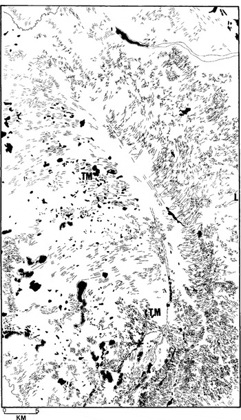
The surge geomorphology of the east-central part of National Topographic Survey (NTS) map area 73E in east- central Alberta is summarized in Figure 6. The geomorphology and sedimentology of the map area comprises the following:
The geomorphology of the east-central part of NTS map area 73E, Alberta, showing all ice-flow-parallel and -transverse ridges.TM are major thrust-block moraines breached by the most recent surge. The last surge in the area produced the dense network of crevasse-squeeze ridges in the eastern half of the map, which grade into the Southernmost flutings of the former Lac La Biche ice stream in the northern half Hummocky moraine and kame-and-kettle topography occur at the southernmost edge. L is the town of Lloydminster.
-
1. In the northern half of the map, the southernmost mega- flutings of the Lac La Biche fluting field document the passage of the Lac La Biche ice stream during recession of the Laurentide ice sheet. These have traditionally been related to vigorous ice streaming (Reference Jones, David-son-Arnott, Nickling and FaheyJones, 1982) and, because of their association with other elements of the surging-glacier land system, are linked here with former surge activity.
-
2. Large thrust-block moraines (TM) constitute the higher topography in the western half of the map. Most of these ridges were formed at the margin of ice moving from the north-northwest, but the most recent features (marked by the southernmost TM on Figure 6 and aligned northwest—southeast) were constructed during the surge of the Lac La Biche ice stream as it flowed from the northwest towards Lloydminster (L) and then from the northeast towards the south of the map area. All of the TMs are truncated or overprinted by the surge geomorphology to the east.
-
3. The eastern half of the map is dominated by a dense network of crevasse-squeeze ridges, which overwhelm the mega-flutings in a down-ice direction towards the centre of the figure and document the final surge of the Lac La Biche lobe as it breached the large TMs in the south.
-
4. A small area of hummocky moraine and kame-and- kettle topography occurs amongst the crevasse-squeeze ridges in the southernmost part of the map.
-
5. Stratigraphic sequences in the map area include severely glaciotectonized deposits in the TMs and multiple tills with interbedded stratified sediments at the centre of the former Lac La Biche lobe (Reference Andriashek and FentonAndriashek and Fenton, 1989; Reference MougeotMougeot, 1995).
It is evident that the landform/sediment assemblages shown in Figure 6 exhibit all the characteristics (with the exception of concertina eskers) of the surging-glacier land- system model (Fig. 4). The juxtaposition of these landforms and sediments at the margin of the palaeo-ice stream, demarcated by the Lac La Biche fluting field, strongly suggests that surging affected this margin of the Laurentide ice sheet during its recession from western Canada.
Discussion
The need to identify former surging glaciers is vitally important for understanding the dynamics of former ice sheets. No individual landform, except probably concertina eskers, can be identified unequivocally as the product of glacier surging. Our land-systems model integrates the suite of landforms and sediments known to be produced by surging- glacier margins. The model can be applied to assessments of the existence of former surging glaciers.
For example, across large parts of the southwestern margin of the Laurentide ice sheet, the occurrence of numerous large thrust-block moraine arcs and associated mega-flutings, linear hummocky-moraine belts, areas of transverse (crevasse-squeeze?) ridges, and stratigraphic sequences comprising glaciotectonized multiple tills/glaciotectonites have been used to suggest that surging behaviour was characteristic of ice recession (e.g. Reference Boulton, Smith, Jones and NewsomeBoulton and others, 1985; Reference Clayton, Teller and AttigClayton and others, 1985; Reference Fisher, Reeh and LangleyFisher and others, 1985; Reference ClarkClark, 1994). In order to prove this hypothesis, further research is required which will apply an integrated investigation of landforms, sediments, stratigraphy, (a land-systems model), palaeogeography and ice dynamics to provide the best interpretation of the landscape. Continued observations from surging glaciers will allow further refinement of the land-system model.
Conclusion
A surging-glacier land-system model, using the geomorphology and sedimentology of known surging glaciers, has been assembled in an attempt to provide a typical process- form signature of palaeo-glacier surging. It combines observations on the geomorphology, sedimentology and glaciology of surging glaciers in Iceland, Svalbard, the U.S.A. and Canada. Although the land-systems model is intended to be a tool for identifying former surging glaciers from their geomorphological and sedimentological record, it is recognized that refinements to the model will be forthcoming as a result of continued research on the dynamics and impacts of contemporary surging glaciers.
Acknowledgements
D. J. A. Evans received financial support for work in Alberta, Iceland and Svalbard from the Royal Society, the Carnegie Trust for the Universities of Scotland, the University of Glasgow and the Royal Scottish Geographical Society.


