


INTRODUCTION
Local contexts affect political behavior (Enos Reference Enos2017; Nathan and Sands Reference Nathan and Sands2023). Many scholars study these effects as functions of the demographic environment, exploring how characteristics of the other people in the same geographic unit affect individuals’ political attitudes or activities (e.g., de Kadt and Sands Reference de Kadt and Sands2021; Kasara Reference Kasara2013; Xu Reference Xu2024). Yet one’s context is not only who else is around them, but also how those people are arranged relative to them in space. A key feature of context is the built environment—the architecture and design of the cities, neighborhoods, and buildings which help determine who comes into contact as people navigate their daily lives (Festinger, Schachter, and Back Reference Festinger, Schachter and Back1950; Grannis Reference Grannis1998; Hillier and Hanson Reference Hillier and Hanson1984; Jacobs Reference Jacobs1961; Small and Adler Reference Small and Adler2019).
Political effects of built environments can be studied at multiple scales, including at the level of entire cities or towns (Gade Reference Gade2020; Patel Reference Patel2014) or the neighborhoods within them (Bollen Reference Bollen2025; LeVan Reference LeVan2020; Nathan Reference Nathan2025). However, the context in which people spend the greatest portion of their time is a much more micro-level built environment: their home. For residents in detached single-family homes, the design of individual residential buildings may have a limited effect on contact with neighbors. But multi-family housing is instead common in much of the world, especially among low-income residents in the rapidly urbanizing Global South, where housing scarcity forces people into living arrangements that produce exposures to potential strangers.
The dominant urban housing form across West Africa, among the world’s fastest urbanizing regions, is the “compound house,” a form of “multihabitation” that echoes similar communal housing found in other developing world regions, including China (Wang et al. Reference Wang, Xu, Qi and Zhang2025; Yu Reference Yu2017), India (Holwitt Reference Holwitt2020), and Latin America (Delgadillo Reference Delgadillo2022). Separate tenants living together within a larger structure share common facilities, such as cooking areas, water taps, bathrooms, and an open-air courtyard that becomes their main socializing and eating space (Appeaning Addo Reference Appeaning Addo2013; Ibukun Reference Ibukun2021).Footnote 1 Anthropologists discuss compound houses as important “enculturing” spaces in which social norms are built among tenants as they are forced to interact during daily residential activities (Pellow Reference Pellow2002; Pittin Reference Pittin and Pellow1996; Schildkrout Reference Schildkrout1976; Schwerdtfeger Reference Schwerdtfeger1982).Footnote 2
We argue that these daily interactions also have an important, but unexplored influence on grassroots urban politics. Forced exposures in shared residential spaces increase neighbors’ visibility to each other. Most directly, visibility facilitates information exchange: even if they do not become friends, simply by having repeated exposure, neighbors learn about and can monitor each other’s political attitudes and behaviors (Bollen Reference Bollen2025). Visibility can also encourage the formation of more substantive social ties, especially “weak ties” (Granovetter Reference Granovetter1973). In turn, these ties can additionally affect political information exchanges and embed residents within social networks that enable political mobilization (e.g., Eubank et al. Reference Eubank, Grossman, Platas and Rodden2021; Siegel Reference Siegel2009; Sinclair Reference Sinclair2012). Through either channel, we outline conditions under which living in a compound house will increase residents’ political activity relative to other, more private forms of housing.
We test these expectations across three analyses on urban Ghana, leveraging the comparative advantages of different data sources to examine distinct facets of our argument. Our first two analyses deploy pre-existing administrative, electoral, and survey data to establish a clear correlation between compound housing and political behavior. First, using granular polling-station level election results geolocated to census tracts, we show that urban neighborhoods with a greater proportion of compounds have higher turnout and more concentrated votes for the same candidates. Second, using an existing nationally representative survey, we also show that urban residents in compound houses are more likely to report joining protests and rallies, participating in political campaigns, and engaging with local government officials than demographically similar residents in other housing types (e.g., single-family homes, self-contained apartments).
We then turn to a third, more original, data source to unpack mechanisms linking compound housing and political behavior. We shift to exploring differences among compound residents who differ in exposure to neighbors, leveraging substantial variation in compounds’ designs and otherwise similar residents’ positions within them. Compound houses are a clear example of “vernacular architecture”: designed by non-architects using readily available materials to meet immediate needs, not to realize artistic visions. Although there are some very general templates, most compounds are piecemeal, highly improvised structures with rooms and amenities added ad hoc as landlords’ budgets allow (Pellow Reference Pellow2002). The result is a dizzying array of design permutations, both within and across compounds catering to tenants of similar socioeconomic status. This translates into variation in the specific manner in which each resident within each compound becomes visible to neighbors.
Our third analysis leverages this variation through an original survey of 1,272 residents living in 391 randomly selected compound houses in 30 neighborhoods of Greater Accra, Ghana, a rapidly expanding city of more than 5 million people.Footnote 3 We measure the degree to which each respondent’s room has a series of design features that affect exposure to other tenants. We also produce rudimentary architectural drawings of each compound, from which we adapt insights from the architecture literature on “space syntax” (Hillier and Hanson Reference Hillier and Hanson1984) and the sociology literature on social ties and building layouts (Festinger, Schachter, and Back Reference Festinger, Schachter and Back1950; Kabo et al. Reference Kabo, Hwang, Levenstein and Owen-Smith2015), to measure the spatial network centrality of each resident, defined by the intersections of each room’s sightlines into common spaces with the shortest walking paths linking rooms to common destinations within that compound, such as the exit(s), water tap(s), or bathroom(s).
The privacy features and network centrality of rooms strongly predict how visible respondents perceive themselves to be to other tenants. In turn, respondents with higher visibility are more likely to gain information about co-tenants’ political behavior, such as knowing how and whether each other voted. These architectural features, and their associated increases in visibility, also predict more “weak” social ties among co-tenants. These ties, in turn, similarly predict having more information about other residents’ political behavior. Social ties among residents also predict which residents are more likely to be able to draw on neighbors’ networks to make claims and interact with local party and government leaders outside of the compounds, increasing the receipt of clientelist benefits. Ultimately, the compound residents with the greatest architecturally defined visibility to neighbors have the most information about other tenants that could facilitate political engagement, while the compound residents whose living situations instead more closely approximate private housing have the least.
These analyses are observational and cross-sectional. Residents are not randomly assigned to rooms, and we cannot trace a causal chain across time that begins with a respondent moving into a new compound and ends with shifts in behavior. Our primary threat to inference is thus endogenous sorting: that the residents in different compounds or rooms were already different. However, we address the possibility of sorting directly in several ways that collectively suggest it is unlikely to account for our results.
First, we show that there are real limits on whether many of our respondents can endogenously sort to begin with: facing a major housing shortage that imposes high search and transaction costs to moving, many have very constrained choice sets when choosing where to live, with little ability to choose among compounds with different architectural features. Second, we explicitly measure the assignment process of respondents to rooms, identifying both the respondents most likely to have been able to endogenously sort and the room features most valued in housing decisions. We then always control for measures of the ability to sort, show that our results are robust to restricting only to the respondents least able to sort, and demonstrate that sorting is especially unlikely to affect our estimates related to the spatial network centrality of respondents’ rooms.
This article makes several contributions. First, we advance a new literature incorporating built environments into the study of political behavior (Gade Reference Gade2020; LeVan Reference LeVan2020; Nathan Reference Nathan2025; Rizzo and Dasgupta Reference Rizzo and DasguptaForthcoming; Schwedler Reference Schwedler2022; Zhao Reference Zhao1998). Long-standing scholarship from sociology suggests that built forms affect social networks (Festinger, Schachter, and Back Reference Festinger, Schachter and Back1950; Jacobs Reference Jacobs1961; Small and Adler Reference Small and Adler2019). Network ties are, in turn, key inputs on political behavior (Eubank et al. Reference Eubank, Grossman, Platas and Rodden2021; McAdam Reference McAdam1986; Sinclair Reference Sinclair2012). But few explicitly link these insights to show how architectural design influences politics through networks, especially with systematic data,Footnote 4 or focus on impacts at as micro-level a scale as a specific building.
Second, we provide a new lens for exploring the political effects of urbanization—one of the most important socioeconomic transformations underway across Africa and the broader Global South (Montgomery Reference Montgomery2008). Urbanization is not simply about agglomerating new people, but agglomerating people into new physical spaces. We contend that design features of these spaces meaningfully affect how urban politics unfolds, even as they are ignored in almost all research on the political effects of urbanization. Yet, if cities matter to politics principally because of how they connect new types of people (Post Reference Post2018), understanding the effects of the urban experience requires studying the specific architectures that “do the connecting” (Zacka Reference Zacka, Bell and Zacka2020, 84).
Third, we contribute to the literature deploying empirical tools from network analysis to explore the relationships sustaining grassroots politics in developing countries. Existing research primarily connects individual-level social networks to political behavior (Cruz Reference Cruz2019; Cruz, Labonne, and Querubin Reference Cruz, Labonne and Querubin2017; Duarte et al. Reference Duarte, Finan, Larreguy and Schechter2025; Eubank et al. Reference Eubank, Grossman, Platas and Rodden2021; Larson and Lewis Reference Larson and Janet I.2020; Ravanilla, Haim, and Hicken Reference Ravanilla, Haim and Hicken2022). We instead join Bollen (Reference Bollen2024) in introducing a new class of network measures moving beyond social ties to capture impacts of spatial ties of co-presence—individuals’ network centrality relative to the paths they and their neighbors take through space.
ARCHITECTURE, NETWORKS, AND POLITICAL BEHAVIOR
Our central premise is that architecture affects political behavior by shaping network ties among neighbors. The simplest network tie that architecture creates is purely informational: by determining who is visible to whom, buildings affect who can monitor and learn about each other. Repeated co-visibility also plants the seeds for the growth of social ties, such as acquaintance or friendship relationships. Both categories of network ties—those that remain at the level of simple visibility or those that develop into substantive social bonds—have implications for how people engage in politics and how the political system engages with them. We conceptualize these as mediators for a relationship between architecture and politics, summarizing our expectations in Figure 1.
Theory: Linking Architecture to Behavior through Visibility and Social Ties

Residential Visibility
Visibility is a function of the built environment. At a macro scale, the layout of a city or neighborhood determines the paths people take to destinations of interest and the resulting probabilities they become co-present with and visible to others along the way (Bollen Reference Bollen2024; Hillier et al. Reference Hillier, Penn, Hanson, Grajewski and Xu1993; Nathan Reference Nathan2025). At a much more micro scale, the locations of rooms and other features within buildings also determine who can see (and hear) each other. Architectural “space syntax” theorists have long argued that social and cultural life is realized through architecture because building designs define the walking paths and fields of vision through which people observe each other and begin to interact (Hillier and Hanson Reference Hillier and Hanson1984; Hillier and Vaughan Reference Hillier and Vaughan2007).
If the architecture of a multifamily housing complex forces residents to spend a significant amount of time in common spaces or to regularly pass in sight of each other, mutual visibility is unavoidable.Footnote 5 Neighbors become far more exposed compared to living in more private housing, such as single-family homes. Even if neighbors keep their social distance—never becoming friends, learning each other’s names, or even speaking—repeated co-presence creates “familiar stranger” ties from which they begin to learn about each other (Bollen Reference Bollen2024; Milgram Reference Milgram1970). While they may have little private information, familiar strangers can gather publicly visible information.
Importantly, this includes information about politics. Exchanges of political information rooted in visibility need not involve extensive conversation or face-to-face interaction.Footnote 6 Instead, when neighbors have no choice but to overhear conversations of other households regularly or to hear or see the media they consume, they will start to learn about which parties or candidates each other support and the political activities in which they participate. Residents can draw similar inferences from political paraphernalia neighbors might display or, for example, from observing clothing (e.g., a party t-shirt) a neighbor wears when a campaign rally is held in the neighborhood (Nichter Reference Nichter2018).Footnote 7 When residents easily observe who comes and goes, or can spot neighbors’ ink-stained fingers, they may be able to infer who turned out to vote.
As indicated in Figure 1, we thus expect a causal path from architecture through visibility to the political information neighbors have about each other. In turn, knowing this information about your neighbors—and knowing that neighbors know it about you—affects both how residents engage in and are engaged by the political arena, producing a further causal arrow in Figure 1 from political information about neighbors to political participation.
Many acts of political participation, from attending rallies or protests to voting in elections, represent collective action problems in which an individual’s behavior is conditioned on beliefs about both others’ behavior and prevailing social norms. Rational egoists might use knowledge of peers’ participation to free-ride (Aldrich Reference Aldrich1993; Ostrom Reference Ostrom2000). But other canonical theories of collective action predict instead that simply observing that one’s peers are also engaging in a particular activity can spur one’s own activity (Ostrom Reference Ostrom2000), even without explicit pressure from those peers (Gerber, Green, and Larimer Reference Gerber, Green and Larimer2008).
In behavioral cascades, seeing that others are participating allows you to update about the risks and rewards of participating, causing you to participate more too, not free ride (Granovetter Reference Granovetter1978; Kuran Reference Kuran1991). In models of social norms, being able to monitor that others are engaging in an activity and, crucially, knowing they will be able to monitor and sanction you, sparks anticipatory compliance with perceived norms that you should also engage (Bicchieri Reference Bicchieri2017; Gerber, Green, and Larimer Reference Gerber, Green and Larimer2008; Ostrom Reference Ostrom2000). Moreover, if neighbors pass information about neighbors’ political leanings along to local politicians, it can also inform who politicians target with their own mobilization efforts (Brierley and Nathan Reference Brierley and Nathan2021; Nichter Reference Nichter2018).
Social Ties
We also expect that the visibility induced by architecture affects political participation via a second major mediator in Figure 1: social ties. A large literature in sociology shows that the probability people form social relationships increases as they repeatedly encounter each other (Browning et al. Reference Browning, Calder, Soller, Jackson and Dirlam2017; Cagney et al. Reference Cagney, Cornwell, Goldman and Cai2020; Small and Adler Reference Small and Adler2019).Footnote 8 As one classic example, Festinger, Schachter, and Back (Reference Festinger, Schachter and Back1950) map social ties among residents of a college dormitory and find that they are a direct function of shared walking paths to building features like exit stairwells and mailboxes.Footnote 9
Our main focus is on the development and effect of Granovetter’s (Reference Granovetter1973) “weak ties.” Repeatedly encountering someone most plausibly leads to basic acquaintance relationships: neighbors regularly engage in short conversations, know basic details about each other’s life, and can begin to influence each other through direct observation and interaction—including via processes of monitoring and social shaming.
Weak tie relationships may not be particularly friendly; the ties that architecture produces often are not deep friendships, what Granovetter (Reference Granovetter1973) would instead call “strong ties.” While friendships could also form downstream from visibility, this need not occur: people still retain a much greater element of choice over with whom they invest in sustained personal relationships. Just because you are often forced into mutual visibility with someone and become acquainted, this does not require you to like each other or to voluntarily seek each other out for further social interaction; indeed, many neighbors prefer to associate only on an instrumental basis to maintain at least some element of privacy. For this reason, we only include a dashed line to strong ties in Figure 1, implying a possible, but not necessary, relationship for our downstream political effects.
Jacobs (Reference Jacobs1961) famously suggests that the social capital that makes cities vibrant is rooted in weak tie, rather than strong tie, relationships among neighbors (also see Zacka Reference Zacka, Bell and Zacka2020). We remain agnostic about whether the denser social capital emerging from weak tie relationships results in a positive lived experience for residents: while some may enjoy the sense of community, others may feel an oppressive loss of privacy. Either way, we predict simply that once weak ties with neighbors become common, they create channels through which social networks can move beyond facilitating a purely information role and instead begin to transmit social pressure and influence among nodes (Siegel Reference Siegel2009), further encouraging participation in normatively valued activities.
The presence of weak ties should only further enhance the political effects of the information exchanges among neighbors highlighted above. Neighbors now gain knowledge of each other’s political preferences not only through passive observation but also because they may directly discuss politics or even encourage each other to adopt their views, enhancing the enforcement of social norms around political behavior. Voting and other forms of participation can come to resemble viral processes of contagion in which social pressure among peers induces further increases in participation (Eubank et al. Reference Eubank, Grossman, Platas and Rodden2021; Sinclair Reference Sinclair2012; Zhao Reference Zhao1998). In sum, Figure 1 also shows this second primary channel from architecture to visibility to weak ties and then through those ties to political information about neighbors and political participation.
Scope Conditions
This argument has several scope conditions. Whether through increased visibility alone or also through social ties, mechanisms rooted in behavioral cascades or social norms should lead to increased political participation under two interrelated conditions. First, in non-repressive, democratic settings, where the state does not impose high costs on one’s political behavior (e.g., participating or not), neighbors’ ability to learn about each other should lead to clustering around each other’s behaviors (Gerber, Green, and Larimer Reference Gerber, Green and Larimer2008). Second, if the baseline rate of political participation is generally high, with one’s neighbors on average already participating, and if politicians typically use information at their disposal about citizens to attempt to mobilize more participation (e.g., Nichter Reference Nichter2018), architecture increasing the opportunities for information-gathering about neighbors’ behavior should typically cause clustering around more participation.Footnote 10
By contrast, in repressive autocratic settings, architecture enhancing neighbors’ ability to monitor each other should instead lead to clustering around the state’s preferred behavior. Here, enhanced monitoring also enables neighbors to inform on each other to the authorities, inviting state punishment.Footnote 11 If a repressive state seeks to demobilize society, as many do, the causal path in Figure 1 from visibility and weak ties through political information about neighbors should instead yield reduced participation.Footnote 12
Alongside this general argument meant to apply across many cases, visibility and weak social ties may also increase political participation through an additional pathway, particularly relevant in clientelist polities. Figure 1 also traces a path through political information about neighbors and then through the political network ties that link residents to others in the surrounding community. The dashed line in Figure 1 again indicates that this alternative path is not necessary for a downstream effect of architecture on participation if political information about neighbors already has the effects described above. We believe, however, that this secondary pathway is also potentially applicable in a narrower range of non-programmatic political systems.
Visibility can transmit additional political information where clientelism is prevalent. For example, by observing changes in neighbors’ economic situations—overhearing discussions of a new job or assistance, seeing a valuable new household item appear—residents can make inferences about which neighbors have the connections to a local political machine through which requests for patronage are fulfilled (Nichter and Peress Reference Nichter and Peress2017). Where voters must channel demands for government assistance up through vertical “problem solving” networks linking them to local brokers (Auerbach and Thachil Reference Auerbach and Thachil2023; Auyero Reference Auyero2000; Brierley and Nathan Reference Brierley and Nathan2021; Kruks-Wisner Reference Kruks-Wisner2018)—known as “relational clientelism” (Nichter Reference Nichter2018)—observing that a neighbor has recently received benefits provides a valuable lead about who to ask for help accessing these same networks to address your own demands.Footnote 13
If neighbors leverage each others’ political network connections in this way, greater visibility could also increase political participation by increasing residents’ incorporation into the local clientelist power structures that condition grassroots political mobilization (Nathan Reference Nathan2025; Nichter Reference Nichter2018). Moreover, more weak social ties among neighbors further enhance this alternative pathway in Figure 1: integration into clientelist networks can now be even better targeted and enforced through residents’ social relationships and associated norms of reciprocity (Cruz Reference Cruz2019; Duarte et al. Reference Duarte, Finan, Larreguy and Schechter2025; Ravanilla, Haim, and Hicken Reference Ravanilla, Haim and Hicken2022).
WHAT ARE COMPOUND HOUSES?
We explore Figure 1 in Ghana, especially in Greater Accra, its capital and largest city. Ghana features widespread multi-family housing and closely fits our scope conditions for a positive effect of architectural visibility on political participation.
Ghana is a non-repressive democracy with a competitive two-party system. Many voters have partisan identities and consume partisan media (Conroy-Krutz and Moehler Reference Conroy-Krutz and Moehler2015), making partisanship observable through everyday interactions. These parties also invest great effort in mobilizing identifiable supporters to turn out (Brierley and Kramon Reference Brierley and Kramon2020; Klaus and Paller Reference Klaus and Paller2017), such that the observability of partisanship also influences parties’ own efforts to increase participation. Official turnout in national elections hovers around 70% of registered voters, with any given citizen more likely to be surrounded by neighbors who are already participating than the reverse.Footnote 14 Electoral competition, including in urban areas, is often clientelist (Nathan Reference Nathan2019; Paller Reference Paller2019), operating similarly to Nichter’s (Reference Nichter2018) account: access to state resources and programs is mediated through network ties voters leverage to make claims on party operatives and politicians (Brierley and Nathan Reference Brierley and Nathan2021; Lindberg Reference Lindberg2010).
Across four major cities, the 2010 census recorded 54% of the population living in compound houses, heavily concentrated in low-income and slum neighborhoods. For the majority of Ghana’s urban poor and working class, compound houses are thus the most immediate built environment through which they experience urban life.
Qualitative interviews conducted by the authors with residents of 24 compounds in six neighborhoods of Greater Accra suggest that everyday exposure to other compound residents is a critical means by which they learn political information about neighbors. When asked how they knew which parties neighbors favored or whether neighbors voted, many explained that it was through overhearing “the way they argue about politics”Footnote 15 and noting that “people talk about politics in the courtyard a lot… they vent about the politicians they don’t like.” Others explained that even without explicitly talking about politics, “their actions show it,”Footnote 16 including through campaign posters hung at their homes.Footnote 17 One resident described, “It’s very easy to know how people vote because people talk a lot about politics… [And] even if people don’t say their party, you can tell who they support from their reactions to other people’s comments.”Footnote 18 Grassroots party operatives have also suggested that they believe compound housing helps facilitate clientelism by making political behavior of low-income voters more easily observable, precluding the need to monitor voters (Nathan Reference Nathan2019, 201–3). But these claims have never been studied systematically.
Most compounds are single storyFootnote 19 and contain anywhere from three to up to 40 separate residences (households) sharing common facilities, arranged around an open-air courtyard or a series of linked courtyards. For many residents, these courtyards become their main eating, cooking, laundry, and socializing spaces, as well as the primary play space for their children, and sometimes worksites for their small businesses—all activities that happen directly on display to other residents (Ibukun Reference Ibukun2021; Pellow Reference Pellow2002).Footnote 20 Courtyards are often divided informally into zones, with residents placing household items and engaging in activities in the areas (“verandas”) immediately in front of their doors.
The modal residence is a single room—a bedroom shared by all household members. Others instead are “chamber and hall” two-room apartments: the back is the bedroom and the front a cooking, eating, and/or socializing space, allowing more privacy. A small minority are multi-bedroom apartments within the compound that still use some shared facilities. In another permutation, some households have enclosed porches for cooking and eating, providing a more moderate degree of privacy. Available facilities vary greatly: some compounds have multiple water taps, toilets, and showers shared by different households, others have a single one of each, shared by all, and others have none, requiring tenants to use public taps and bathrooms elsewhere. A small minority of rooms have private toilets or showers added on outside, but virtually no one has plumbing or running water inside their rooms.
This housing style is not unique to Ghana. Similar communal housing is common across West Africa (Prussin Reference Prussin1986; Schwerdtfeger Reference Schwerdtfeger1982; Yakubu Reference Yakubu2022). In Mexico and some other Latin American countries, compound-style structures with shared courtyards—“vecindades”—are widespread in slums (Delgadillo Reference Delgadillo2022). In many Indian cities, tenements known as “chawls” feature small apartments arranged around central courtyards with shared facilities (Holwitt Reference Holwitt2020). Historically, compound-style housing was once widespread in many other cities as well, including in China (Yu Reference Yu2017; Wang et al. Reference Wang, Xu, Qi and Zhang2025) and Russia (Morton Reference Morton1980), but has been displaced over time after major (often state-led) initiatives to construct formal apartments. Elsewhere, however, communal housing persists, or even becomes more common, amid modern urbanization if formal housing provision fails to keep up with demand; it is not simply an anachronism from an earlier urban era. In urban South Africa, for example, multihabited structures are now increasing as a share of total housing stock, with “backyard dwellings” converting what were previously yards of detached single-family homes into compound-style courtyards serving the urban poor (Rice, Scheba, and Harris Reference Rice, Scheba and Harris2023).
Ghana’s compounds first became prevalent as a village housing form, based on traditions long pre-dating colonial rule, but adapted to urban life under colonialism (Ibukun Reference Ibukun2021). The current designs prevalent in Accra were already widespread as of the 1850s (Parker Reference Parker2000, 25–6). Because of these deep roots, there are some broad differences across compounds initially built by different ethnic groups. Traditional Akan compounds—Ghana’s plurality group—feature an outer rectangle of inward-facing rooms around a single courtyard (Afram and Korboe Reference Afram and Korboe2009; Ibukun Reference Ibukun2021). Hausa-style compounds that historically catered to Muslim populations instead prioritized conservative beliefs about women (purdah) by creating gender-segregated spaces (Schwerdtfeger Reference Schwerdtfeger1982; Prussin Reference Prussin1986; Pellow Reference Pellow2002). But in the modern city, with housing demand far outstripping supply, these differences have long-since broken down as landlords improvise and add features to compounds on a piecemeal basis to maximize revenues—subdividing rooms, (partially) filling in courtyards with new rooms, and adding rooms on the exterior (Pellow Reference Pellow2002; Afram and Korboe Reference Afram and Korboe2009).
The result is that while compounds in general create far more exposure to one’s immediate neighbors, on average, than other housing types (e.g., single-family homes, self-contained apartments), there is also enormous compound-by-compound variation that affects how exposed residents truly are. Figures 2–4 are example layout diagrams produced in our survey.Footnote 21 As one example, note that some rooms open directly to a shared courtyard or hallway in constant view of neighbors, while others are exterior-facing, allowing more privacy.
Layout Example #1
Note: An example compound from our survey. “T” indicates toilet, “S” indicates shower, and “C” indicates the open-air courtyard. Bi-directional arrows indicate the main exit to the street. The black circle in a square is the communal water tap (typically a large plastic tank). Code numbers indicate the rooms with respondents. Unnumbered rooms are non-residential spaces (including shops facing the street). All room sizes are approximate.

Layout Example #2
Note: The unidirectional arrow at the bottom is a separate side exit; some residents can move in and out without passing in view of most other rooms. Also note some rooms (#8 and #9) have nearly private sitting areas in front of their door, while most are in view of many neighbors. All room sizes are approximate.

Layout Example #3
Note: A narrower hallway acts in place of the courtyard. Two rooms (#1 and #2) exit directly to an exterior lane. There are showers but no water or toilet; residents must access these elsewhere. All room sizes are approximate.

We focus in particular on urban compounds. While compounds are also common in rural Ghana, the stereotypical rural compound houses a single extended family. Urban compounds instead are substantially more likely to contain co-tenants who are (initially) strangers (Appeaning Addo Reference Appeaning Addo2013), such that it remains a more open question in cities whether compounds facilitate new information exchanges and social ties.Footnote 22
The modal urban compound is owned by an absentee landlord who leaves a family member on site as building manager. Many rooms are rented to unrelated, often multi-ethnic, tenants who typically have not met before. In other cases, the landlord personally lives on the property, or instead the compound remains a “family house” for a single extended family, some of whom live for free while others pay below-market rent (Appeaning Addo Reference Appeaning Addo2013).
Overall, in our survey below, we encountered landlords personally living on site in 39% (154) of the compounds, while just 9% (37) were “family houses” rather than rental properties—a far less common phenomenon than in rural areas. Thus, in a typical urban compound, the landlord is not a regular presence, and many co-tenants are unrelated. Norms of “amicable” co-existence (Afram and Korboe Reference Afram and Korboe2009, 43) evolve in some compounds in which neighbors attempt to keep to themselves and avoid intervening in each other’s affairs (Appeaning Addo Reference Appeaning Addo2013). In our interviews, tenants regularly described that they might go years without being properly introduced and learning each other’s real names or speaking at any length. The emergence of social ties within a compound is thus not a given but varies empirically.
HOUSING TYPE PREDICTS POLITICAL BEHAVIOR
Our analysis proceeds in separate stages. We begin by establishing our central hypothesis that living in a compound predicts greater political participation compared to other housing in which residents have more privacy from neighbors. We do so using pre-existing data sources that compare compounds to other housing types: first, a combination of geocoded census data and electoral results, and second, an existing nationally representative survey measuring political participation. We then explore potential mechanisms for these associations in the subsequent sections, turning to our original survey, which focuses instead on intra-compound variation. For replication data, see Bollen and Nathan (Reference Bollen and Nathan2026).
We begin in Table 1 using polling station returns from the 2012 and 2016 presidential elections, geolocated (CERSGIS 2016) to Enumeration Areas (EAs, or tracts) in Ghana’s 2010 census (GSS 2013).Footnote 23 We subset to Ghana’s four metropolitan areas to focus on urban voting.Footnote 24 Urban polling station catchment areas do not necessarily correspond to EA boundaries (which have no administrative significance), so we assign each polling station the census characteristics from a spatially weighted average of EAs within 500 m of its location, with weights declining in distance.Footnote 25
Turnout by Compound House Proportion, Urban Polling Stations (2012 and 2016)

Note: Significant at $ p<0.10 $
; *
$ p<0.10 $
; * $ p<0.05 $
; **
$ p<0.05 $
; ** $ p<0.01 $
; ***
$ p<0.01 $
; *** $ p<0.001 $
. Standard errors clustered by parliamentary constituency year.
$ p<0.001 $
. Standard errors clustered by parliamentary constituency year.
In the first three columns of Table 1, the outcome is turnout as a proportion of registered voters. The explanatory variable is the proportion of homes in the immediate vicinity that are compounds.Footnote 26 We control for the ethnic composition and fractionalization (diversity) of the area immediately around each polling station and essentially all measures of socioeconomic status available on the census,Footnote 27 in an attempt to carefully restrict our comparisons to polling stations with similar wealth but different housing.Footnote 28 Columns 1 and 3 include city (region) and election-year fixed effects, while column 2 instead includes parliamentary constituency-year fixed effects.Footnote 29 Standard errors are clustered by parliamentary-constituency-year.
Across columns 1–3 of Table 1, polling stations with more compounds have significantly greater turnout than otherwise demographically similar polling stations with fewer compounds. These associations are substantively large, including in comparison to other established predictors of participation, such as socioeconomic class (Kasara and Suryanarayan Reference Kasara and Suryanarayan2015). From column 1, a one standard deviation shift in the proportion of housing that is compounds has a 3.9 times greater impact on turnout than a one standard deviation shift in the proportion of residents with running water in their homes, a strong indicator of neighborhood wealth; a 1.8 times greater impact than a one standard deviation shift in the English literacy of surrounding residents; a 2.9 times greater impact than a one standard deviation shift in the proportion of surrounding residents with secondary education; and a 4.8 times greater impact than a one standard deviation shift in formal sector employment. Notably, these three latter covariates are direct indicators of class status that previous work already explicitly links to variation in political participation in this same setting (Nathan Reference Nathan2019).Footnote 30
Moreover, column 3 shows that the association between compound housing and turnout is significantly increasing in a polling station’s electoral competitiveness, adding an interaction term with the absolute value of the margin in two-party vote share between Ghana’s dominant parties (NDC and NPP). Although compound housing remains significantly predictive of more turnout at all levels of competitiveness,Footnote 31 this relationship is largest at the lowest margin stations, where grassroots campaign efforts to mobilize each marginal voter should be most intensive. This suggests that compound housing’s impact is maximized in the presence of active efforts to harness the social structures and norms created by this housing form. It is also consistent with anecdotal claims in pilot interviews, and elsewhere (Nathan Reference Nathan2019), that urban party organizations often focus campaigning at compounds because they believe this can more efficiently activate voters.
In columns 4–5, the outcome is instead a Herfindahl index of vote shares by presidential candidate, capturing the probability that two votes chosen at random were for the same candidate. This measures how much voters within these localized areas successfully coordinate on who to support (Conroy-Krutz Reference Conroy-Krutz2018) and shows more coordination in polling stations with more compound housing, again suggestive of greater collective action.
While Table 1 is consistent with our expectations, it only explores a single form of participation (voting).Footnote 32 We supplement with individual-level survey data. We draw on the 2017 Ghana Living Standard Survey (GLSS), a nationally representative 13,833 respondent survey conducted by the Ghana Statistical Service (GSS 2018). Unlike our original survey below, this survey was conveniently conducted directly before and after a major election (in December 2016) and includes a rich battery of questions on various forms of participation in the ongoing or just-concluded campaign. We subset to the 5,916 urban respondents and examine differences in political behavior by housing type.
Our results are in Figure 5, which reports coefficients and both 90% and 95% confidence intervals for an indicator for living in a compound house in separate OLS regressions for each outcome along the y-axis, with standard errors clustered by survey Enumeration Area. The comparison housing types are primarily single-family homes or formal self-contained apartments. We again control for the best available demographic controls to capture underlying differences in socioeconomic status, and also include region (province) fixed effects.Footnote 33 In general, compounds are less desirable than single-family homes or formal apartments, and we show in Section S4 of the Supplementary Material that respondents in compounds are understandably poorer and less educated, on average, than those in other housing. But these differences are not very stark: there is still substantial overlap on these covariates across housing type (Section S4 of the Supplementary Material), and the housing market is by no means perfectly sorted on wealth, allowing us to reasonably fit models controlling for socioeconomic status.Footnote 34
Compound Housing and Political Action
Note: Subset to urban respondents, comparison of those living in compound houses versus other housing types (e.g., single-family homes, formal self-contained apartments) in the nationally representative sample from the Ghana Living Standards Survey (GSS 2018), with demographic controls.

Figure 5 shows that compound housing is also associated with other forms of participation beyond voting. Those in compound houses are significantly more likely to report that they have participated in a campaign, attended a rally, and attended a protest than similar respondents in more private housing. At the $ \alpha <0.1 $
level, they are also more likely to have contributed funds to a campaign or personally contacted a local politician about a community issue.
$ \alpha <0.1 $
level, they are also more likely to have contributed funds to a campaign or personally contacted a local politician about a community issue.
These effects are substantively large in comparison to our main covariates capturing respondents’ socioeconomic status, such as an assets (wealth) index, whether they work for profit (are employed), or their education level. The estimated relationship between compound housing and joining a campaign is 11 times larger than the relationship between a one standard deviation change in the asset (wealth) index and campaign participation, twice as large as the relationship with working for profit, and dramatically larger than the impact of education level, which itself has little correlation with joining a campaign. Similar patterns persist for other forms of participation. For joining a protest, compound housing shows a coefficient 4.9 times larger than working for profit, 3.5 times larger than a one standard deviation change in the assets index, and again has a dramatically larger association than education level, which has no association with this outcome. For attending a rally, compound housing predicts an increase 1.4 times the size of working for profit and 2.7 times the size of a standard deviation increase in education.
Finally, respondents in compounds are also signed as turning out to vote more often, consistent with Table 1. But this difference is not statistically significant, likely due to ceiling effects from over-reporting of turnout.Footnote 35 Overall, however, across Table 1 and Figure 5, a clear pattern comes into focus: residents of compounds participate more in various forms of political activity.
MECHANISMS: THE COMPOUND SURVEY
We complement these analyses by fielding an original survey to isolate specific architectural features that are the most likely mechanisms for these relationships. To do so, we take our analysis down a level from a comparison of compounds versus other housing types to an analysis instead focused on variation among residents within compounds. We leverage substantial differences in design within and across compounds that expose otherwise similar residents to neighbors to different degrees. In this section, we explain the sampling and design of our survey and introduce the measures for our key explanatory variables.Footnote 36 We also explain how, although our analyses all remain non-experimental, we attempt to explicitly observe and then systematically control for possible endogenous sorting of respondents.
Sampling and Design
Rather than seeking a fully representative sample of compound house residents, we ensure selection of a tightly comparable set of compounds with sufficient across- and within-compound variation in architectural features to enable a rich comparison of residents with differing exposures to others. We first subset the 2010 census Enumeration Areas (EAs) for Greater Accra to those in the top third of the distribution of compound house prevalence (70% or more of the houses are compounds). This purposefully restricts our sampling frame to low-income (slum) neighborhoods, where compound housing predominates. We stratify the remaining EAs by ethnic and religious composition to ensure variation across broad categories of compound house styles associated with different groups’ traditional practices.Footnote 37 We randomly sample 30 EAs (neighborhoods). Within each EA, an enumerator was directed to a randomly selected GPS point, from which he began a random walk to randomly sample 13 compounds.
Using data on compound characteristics collected at this initial visit, enumerator teams subsequently returned to each compound and sampled respondents after stratifying on within-compound variation in layouts. Enumerators selected either three or four respondents per compound, depending on its size. In each, they always interviewed either the landlord or a member of the landlord’s family (if available). In compounds with interior as well as exterior rooms, enumerators were directed to sample one respondent who lived in an exterior-facing room. Enumerators were also directed to sample respondents in the interior of the compound who varied in spatial position (e.g., near vs. far from the main entrance; interior rooms that did versus did not open onto the main courtyard), with the exact strata varying based on each compound’s features. Our final sample includes 1,272 respondents across 391 compounds, with a mean of 3.25 per compound. All interviews were conducted in May 2024, face-to-face, and lasted approximately 20–30 minutes.Footnote 38
While these interviews were underway, a designated enumerator completed a separate survey about the compound’s architectural features and produced a detailed sketch of its layout and amenities in consultation with the landlord or the landlord’s representative.
Quantifying Architectural Variation
We construct two explanatory variables from the survey, varying at the individual level within compounds. The architectural exposure index aggregates room features that increase quotidian exposures to co-tenants: whether respondents cannot cook inside their room(s), whether they cannot eat meals inside, live in a single-room rather than multi-room apartment (allowing for fewer activities outside), whether respondents do not have an enclosed or partially enclosed porch (allowing them to sit out of direct sight), whether their room opens to the courtyard rather than a more private hallway or exterior street, whether their room is on the ground floor instead of an upper floor (enabling more private entry/exit), whether they must use a shared shower or toilet, and whether they do not have access to an in-room air conditioner (enabling more time indoors). The index is the sum of these items (0–9), with higher values representing less private room features.Footnote 39
Our second explanatory variable combines two spatial network centrality measures calculated based on each respondent’s location within their compound’s layout. We translate our architectural sketches into GIS shapefiles with rooms, doors, and all features of interest (water taps, showers, toilets, and exits) as polygons. We then calculate sightlines for each room, meant to represent the most direct view from each door and (potential) front or side windows (see Figure 6a)—the open areas of the compound residents most easily see if sitting in or in front of their room (i.e., at the stoop/veranda).Footnote 40 We also simulate each room’s shortest walking path through the compound to reach features of interest within it (Figure 6b–d).
Steps in the Architectural Network Centrality Calculations
Note: In the same compound as Figure 2, (a) for each room, we calculate sightlines into open spaces within the compound (blue cells); (b)–(d) for each room we calculate the shortest path from the room’s door to each compound feature (green cells) through the navigable space (red cells). Iterating over all combinations of rooms and features, we calculate how many paths for each room pass each other room’s sightlines.

Combining the sightlines and paths, we calculate the betweenness centrality of each room: analogous to the social network statistic of the same name, this counts the number of other rooms’ shortest paths to each compound feature that pass through each room’s sightline. This reflects both each resident’s ability to see other tenants as these tenants pass through the compound and each resident’s visibility to other tenants if the resident is sitting in front of their own room (typically, the most common spot to sit to cook, eat, and socialize). We average the betweenness centrality score for all compound destinations. For example, in a compound with an exit, toilet, shower, and water tap, the betweenness centrality assigned to each room is the average number of neighbors’ paths across each of these four features that pass that room’s sightline.Footnote 41
Separately, we also calculate each room’s passing paths centrality, which adapts to our spatial setting the logic of the social network statistic outdegree centrality. Averaging over each compound feature, we calculate the number of other rooms’ sightlines that residents must pass to get from their room to that feature. This captures respondents’ visibility to their neighbors while going about their own daily routines. Figure 7 demonstrates an example of the betweenness and passing paths centrality values for each room in the example compound from Figure 2.
Layout Sketch #1 with Centrality Scores
Note: The same compound from Figure 2 with average raw scores for betweenness centrality (b) and passing paths centrality (p) included. These are averaged over paths to all features (destinations) in the compound: the exit, shower, toilet, and water tap. Taking the mean of (b) and (p) together captures the joint cumulative exposure of each room to other tenants. Rooms like #6 are exposed far more than rooms like #13.

Because these centrality scores capture different types of potential exposures to co-tenants—both the paths of other tenants in relation to respondents’ rooms and respondents’ paths in relation to other tenants’ rooms—our primary specifications combine them into a joint measure by taking their average.Footnote 42 This joint measure captures the collective total exposures to other tenants that each room’s architectural position creates as all tenants are coming and going during their daily routines.Footnote 43 We calculate both a raw and a normalized version of this measure for each respondent. The raw version, used in the main text, is simply the average count across each exposure of each type, capturing the total number of other people to whom a respondent is likely regularly exposed.Footnote 44 We show the distribution of this variable in Section S11 of the Supplementary Material.Footnote 45
A possible concern is that both of our main measures—the architectural exposure index and the architectural centrality index—only capture potential visibility, but cannot measure how much time each respondent actually spends in direct view of others. For example, if an especially introverted person avoids leaving her room, these variables would overcount her true exposure to other residents, while her introversion could also separately affect the ties she forms. However, in Section S12 of the Supplementary Material, we show that our findings with these data are robust to restricting to situations in which respondents must leave their rooms, regardless of personality traits, demonstrating that variation in introversion is unlikely to account for our results.
Accounting for the Possibility of Sorting
Because these survey data are cross-sectional and we cannot observe over time changes in respondents’ behavior after they move into new compounds, our central challenge is endogenous sorting: does the assignment process of respondents to compounds, and to apartments within them, confound any relationship between architecture and the downstream variables in Figure 1? While we can never fully rule out confounding without random assignment, we can cast doubt on the plausibility that sorting is a primary explanation for our results by measuring the assignment process of respondents to their homes and then explicitly controlling for predictors of (potential) sorting in all analyses.
Before detailing our approach to controlling for sorting, it is first important to note that the overall risk of sorting may be less extreme than some may believe. Substantial frictions in the informal housing market constrain choice sets, restricting the latitude residents of compounds have to plausibly sort across apartments based on preferences for particular room features that might also be correlated with our outcome variables. Typical of rapidly urbanizing cities across the Global South, Greater Accra faces dramatic housing scarcity, raising transaction and search costs to moving.
Regarding transaction costs, landlords have great leverage, typically charging tenants 2 years’ rent upfront in cash and leaving tenants little recourse to reclaim an outstanding balance (Arku, Luginaah, and Mkwandawire Reference Arku, Luginaah and Mkwandawire2012). This creates a liquidity constraint: poor tenants, who face especially high borrowing costs, often cannot easily upgrade to a better room elsewhere even if their financial situation marginally improves. For others, renting is so prohibitively costly that they default to only considering compounds owned by (extended) family, where they can live rent-free or at below-market rates (Afram and Korboe Reference Afram and Korboe2009; Appeaning Addo Reference Appeaning Addo2013).
In the absence of widespread public listings, search costs are high. Most people can only locate vacancies through the knowledge of family or social ties, limiting their search to only a tiny subset of available units. The most common reported means of finding one’s current room is by going through family members (62% of respondents),Footnote 46 followed by asking friends or co-workers (14% of respondents) who know of a vacancy. While social ties thus play a clear role in sorting respondents into housing, it is not clear why the vacant rooms that respondents’ family or friends happen to own or be aware of would systematically vary in their specific architectural features, such as their centrality within building layouts.Footnote 47
Given these frictions, it is unsurprising that the large majority of respondents (70%) report having no real choice over apartments, saying they only considered a single option when moving to their current home, inconsistent with the possibility of active sorting on design preferences across much of our sample.Footnote 48 Moreover, because a decision to remain in a room could instead be a passive form of sorting—implicit selection on preferences for current room features—we ask respondents if they believe they could afford to find a similarly good room elsewhere or if they are instead essentially locked financially into their current option as their only viable choice. A similar majority (70%) report feeling stuck. Consistent with both statistics, tenancy is sticky: the average respondent has lived at the same compound for 19 years (median 12).Footnote 49
Despite these real constraints on selecting apartments, ability to pay—rooted in differences in socioeconomic status—could still predict ability to sort into apartments of different types among some respondents. In particular, Section S15 of the Supplementary Material shows that two covariates measuring socioeconomic status predict the architectural exposure index, with relatively wealthier respondents living in multi-room (rather than single-room) apartments with marginally more amenities (e.g., interior kitchens, enclosed porches). These features plausibly factor into rent prices, at least among our subset of rent-paying, non-relatives of landlords.Footnote
50 Similarly, when we examine the 154 landlords in our sample—residents with mechanically the greatest ability to sort within compounds, as they can ostensibly pick whichever room they want—we again find that they tend to live in apartments with marginally lower values on the exposure index, mostly driven by them assigning multi-room units to themselves (Section S16 of the Supplementary Material). Moreover, we find that stating it would be easy to move—our explicit measure of respondents’ self-professed ability to pay the transaction and search costs of moving—also negatively predicts the architectural exposure index, at least at the $ p=0.1 $
level, again suggesting those with the greatest ability to pay choose rooms with more private amenities (Section S15 of the Supplementary Material).
$ p=0.1 $
level, again suggesting those with the greatest ability to pay choose rooms with more private amenities (Section S15 of the Supplementary Material).
For this reason, all analyses below explicitly control for these differences in respondents’ characteristics: we always control for multiple measures of socioeconomic status, including respondents’ assets (wealth), education, and employment, as well as the variables measuring abilities to have sorted (considering multiple options, believing you can afford to move elsewhere) and the process by which respondents found their homes (i.e., via family or social ties). We also always control for whether the respondent is the landlord or related to the landlord. In doing so, we thus always condition on the most likely predictors of sorting. Moreover, in robustness tests, we subset only to respondents least likely to have been able to sort into rooms based on their ability to pay by explicitly restricting only to those who either do not believe they could afford to move or did not look at multiple options (Section S17 of the Supplementary Material). If sorting were the primary cause of our results, removing these respondents who most plausibly endogenously sorted should substantially change the findings (Hopkins and Williamson Reference Hopkins and Williamson2012), but it does not.
Most importantly, we also find that the possibility of sorting appears far less likely for our other main explanatory variable, the architectural centrality index, which measures the position of each apartment within the compound layout. Unlike the exposure index, the centrality index is not predicted by our measures of socioeconomic status (Section S15 of the Supplementary Material). One’s self-reported ability to have actively or passively sorted—considering multiple options or believing it is easy to find a new apartment—also does not predict architectural centrality (Section S15 of the Supplementary Material). And despite having unfettered ability to choose the most desirable apartment in each compound, landlords do not choose rooms with different values on the centrality index (Section S16 of the Supplementary Material). Landlords also do not sort their family members into rooms with different architectural centrality scores (Section S16 of the Supplementary Material).Footnote 51 Moreover, if residents placed value on architectural network centrality when choosing rooms, we should expect it to be correlated with length of tenancy in a compound: vacancies should be more frequent in rooms with less desirable features, with residents leaving as soon as they can, while tenants instead stick longer in desirable rooms. But we find no evidence of this: years at the compound are not correlated with architectural features of respondents’ apartments (Section S18 of the Supplementary Material).
These patterns are starkly inconsistent with the network centrality of a room even being a desirable room feature on which residents attempt to sort. While some inputs in our architectural exposure index capture basic amenities (e.g., whether an apartment has two rooms, or a kitchen) one would expect to be advertised in an apartment listingFootnote 52—and thus that could clearly be salient in renters’ decision-making—the variation in sightlines captured by our network centrality index is far more subtle.Footnote 53
Our analyses for the centrality index again always control for the same covariates as for the exposure index, and we again find these results are robust to restricting to respondents least likely to have sorted based on either not considering multiple options or not believing they can afford to move (Section S17 of the Supplementary Material). Crucially, we also show that our results for the centrality index are robust to controlling for the exposure index itself (Section S19 of the Supplementary Material); to the extent that the exposure index captures amenities correlated with rent, and thus proxies for additional unobserved variation in residents’ ability to pay, adding it as a control provides further confirmation that wealth does not confound the relationships between the architectural centrality of rooms and our outcomes below.
COMPOUND SURVEY ANALYSES
Compound architecture predicts both respondents’ perceived visibility to co-tenants and the formation of (weak) social ties with them. In turn, visibility and weak social ties predict respondents’ access to political information and networks. Importantly, because compounds, on average, increase residents’ visibility to immediate neighbors relative to other housing types, these patterns in the compound survey help explain our finding above that compound house residents are the most politically participatory.
We estimate these relationships with OLS regressions controlling for both individual- and compound-level covariates, attempting to compare observably similar people who live in different architectures. At the respondent level, we control for age, gender, education, ethnicity, an assets index, commuter status, the proportion of life spent in the compound, whether they work in the formal or informal sector, whether they are a (distant) relative of the landlord, whether they are the landlord, how they found the house, whether they considered multiple options, how easy it would be for them to move, and when the interview was conducted (see Section S20 of the Supplementary Material). We supplement these respondent-level controls with compound-level variables, including the compound’s roof and wall materials, which proxy for overall compound wealth/quality, the total number of rooms in the compound,Footnote 54 the proportion of these rooms that belong to family members, and the estimated ethnic diversity of the compound.Footnote 55 We cluster standard errors by compound.Footnote 56
Architecture, Visibility, and Social Ties
If our theory is correct, we should see a strong relationship between our measures of architecture and our proposed mediating variables—visibility and (weak) social ties. Our primary measure of visibility is to ask respondents the proportion of time they typically see co-tenants when exiting their room to leave the compound. As a secondary measure, we also have enumerators record whether other tenants were either present and in view of the respondent at the start of the interview or instead came out to watch while it was happening—a real-life snapshot of visibility.Footnote 57
Figure 8 demonstrates that, as expected, an increase in respondents’ architectural exposure index is associated with an increase in both the reported likelihood that respondents come into contact with neighbors on their way out of their rooms and an increase in the likelihood that enumerators report other people watching the interview. Similarly, as respondents’ architectural network centrality increases, so too does the likelihood that they report running into their neighbors. Centrality does not predict others watching the interview, however.Footnote 58
Predicting Observed Visibility from Architectural Features
Note: Coefficients from OLS regressions with covariates as noted in the text, standard errors clustered by compound, and 95% and 90% confidence intervals.

Figure 9 then plots the relationship between architecture and social ties (on the left panel) and between visibility and social ties (on the right panel). We create a weak ties index composed of three items reflecting the presence of acquaintance relationships among residents.Footnote 59 The first is whether respondents believe their neighbors can easily find out about a family problem or issue that they might be having (perceived lack of privacy). The second is the proportion of other residents respondents believe know their name. The last is the proportion of other residents whose names respondents know. As an alternative measure of weaker social relationships, we also include the proportion of other residents’ ethnicities that the respondent believes they know.Footnote 60 As noted in the discussion of Figure 1, we have more ambiguous expectations about strong tie relationships, but also include an index for them in Figure 9. This combines whether respondents report socializing with others in their compound, claim to have more friends within their compound than in their neighborhood, and report that either of the two people (beyond immediate family) that they talk to most live in their compound.
Predicting Social Ties with Architecture and Visibility
Note: Coefficients from OLS regressions with covariates as noted above, standard errors clustered by compound, and 95% and 90% confidence intervals.

Figure 9 demonstrates that as architectural exposure and centrality increase, so too does the likelihood that respondents report weak ties in their compound and knowledge of co-tenants’ ethnicity (left panel). This pattern is mirrored when using visibility as the explanatory variable instead (right panel). Neither set of explanatory variables consistently predicts strong tie relationships, however, consistent with the idea that co-tenants still have a greater degree of choice about who they engage in deeper friendships.
These relationships between architecture and weak ties are meaningfully large when benchmarked to other predictors. Two controls—the proportion of a respondent’s life lived in the compound and whether a respondent is related to the landlord, and thus systematically more likely to have family members among her co-tenants—are both understandably also strong predictors of social ties among co-tenants. But the increase in weak ties from a one standard deviation increase in architectural network centrality is equivalent to the increase in weak ties from a respondent living 10 additional years in the compound. It is also equal to almost half (46%) of the increase in weak ties from being related to the landlord and being more likely to have relatives among the other tenants. A one standard deviation increase in the architectural exposure index is equivalent to living an additional 8 years in a compound, and represents one third (32%) of the predicted increase from being related to the landlord.
In Section S22 of the Supplementary Material, we conduct a mediation analysis (Imai et al. Reference Imai, Keele, Tingley and Yamamoto2011) and show that most of the association between the architectural variables and the measures of weak social ties works through our visibility measures as intermediate variables, as diagrammed in Figure 1. We do not claim that the sequential ignorability assumptions necessary for causally identified mediation analyses are satisfied in our application. We simply use the mediation toolkit to decompose conditional associations to aid descriptive interpretation.Footnote 61
We also address concerns that having others present at an interview—our secondary measure of visibility—could affect social desirability bias, as fully private interviews could not always occur where architecture afforded so much visibility to co-tenants. Section S23 of the Supplementary Material instead uses people watching as a control and finds similar patterns for the other results.
Visibility, Social Ties, and Political Outcomes
Above, we find clear results for the first step in our theory: architecture influences respondents’ visibility and weak, but not strong, ties. Next, we expect that increased visibility and social ties influence the political information that residents gain about each other. If true, enhanced political information should help facilitate collective action, suggesting an explanation for the increased political behaviors in Table 1 and Figure 5.Footnote 62
Figure 10 shows that our proposed mediators—visibility and social ties—consistently predict more political information exchange within compounds—the same types of information that existing literature expects to facilitate mobilization and participation (Granovetter Reference Granovetter1978; Nichter Reference Nichter2018; Eubank et al. Reference Eubank, Grossman, Platas and Rodden2021). Visibility when exiting one’s room strongly predicts more political information exchange within the compound (top left panel), especially knowledge about co-tenants’ party support (vote choice) and expectations that other residents know one’s own party preferences in return. Moreover, respondents with weak tie relationships within their compound are significantly more likely to expect other residents to know which party they support, know which parties other residents support, know whether other residents voted (turnout), talk about politics with other residents, and list other residents as a regularly used source when they seek out information about a political issue (top right panel). Similarly, knowledge of other residents’ ethnicity—our alternative measure of a weak(er) tie—predicts most measures of political information exchange.
Political Information Inside Compounds
Note: Coefficients from OLS regressions with covariates as noted above, standard errors clustered by compound, and 95% and 90% confidence intervals.

The last panel of Figure 10 presents a “reduced-form” relationship between architecture and these outcomes. We find that both of our architecture measures significantly predict political information exchange within compounds. Breaking down this result into its component items, our architecture measures are especially predictive (at the $ \alpha <0.05 $
level) of political knowledge about each other’s voting preferences: respondents with greater centrality within their building’s layout or more architectural exposures in their room are significantly more likely to know who other tenants support politically and believe other tenants also know who they support.
$ \alpha <0.05 $
level) of political knowledge about each other’s voting preferences: respondents with greater centrality within their building’s layout or more architectural exposures in their room are significantly more likely to know who other tenants support politically and believe other tenants also know who they support.
These associations continue to be meaningfully large. The increase in the aggregate political information index from a one standard deviation increase in architectural network centrality is equivalent to that from an additional 6 years living in the same compound and represents a little above half (55%) of the increase from being the landlord’s relative and being likely to already be related to other tenants.
Our final analyses explore two further sets of outcomes that could also demonstrate residents’ enhanced ability for collective action. First, Figure 1 also proposes an additional downstream relationship with political network ties outside the compound, especially relevant in clientelist environments, but notes that such a relationship is not necessary for an overall effect on political behavior. Figure 11 repeats the analyses in Figure 10 for political network connections outside the compound—respondents’ ability to contact local brokers and intermediaries—as well as receiving patronage benefits. In the top panels, we find associations consistent with our expectations: respondents visible to neighbors during interviews report more ties to local political actors outside compounds and receiving more patronage. One’s likelihood of running into co-tenants is also positively associated with interacting with District Assemblymembers (city councilors), local traditional chiefs, and local party leaders. Respondents with more weak tie relationships with co-tenants, or more knowledge of co-tenants’ ethnicity, are also more likely to have developed ties outside the compound, as well as to have received patronage benefits.
Political Ties Outside of the Compound
Note: Coefficients from OLS regressions with covariates above, standard errors clustered by compound, and 95% and 90% confidence intervals.

However, in the bottom panel of Figure 11, we do not find clear reduced-form relationships between our architecture measures and ties outside of the compound, other than that the architectural centrality index significantly predicts greater contact with local party leaders—the main electoral brokers in this context (Brierley and Nathan Reference Brierley and Nathan2021). Thus, while we can show that architecture significantly predicts visibility, social ties, and political knowledge within the compound, and that each of these variables, in turn, predicts connections outside the compound,Footnote 63 we cannot show a direct effect from architecture all the way to connections outside the compound.
Second, and finally, in Section S26 of the Supplementary Material, we show that our architectural variables nonetheless predict other more sociological indicators of grassroots cooperation, still consistent with our broader claim that these design features facilitate cooperative norms. Both the exposure index and architectural network centrality predict more self-help (private social insurance) among compound residents, a cooperative behavior that Borisova, Smyth, and Zakharov (Reference Borisova, Smyth and Zakharov2024) similarly use to measure the presence of cooperative norms and social capital within apartment buildings.Footnote 64 Moreover, architectural centrality predicts greater perceptions of compound safety (e.g., from burglary), consistent with claims that designs that put more “eyes on the street” (or on the courtyard) facilitate cooperative self-policing (Jacobs Reference Jacobs1961; Newman Reference Newman1972).
CONCLUSION
Our article brings an empirical focus on vernacular household architecture into the study of urban politics. We study contextual political effects that operate through built environments, departing from existing literature’s more typical focus on demographic environments (Kasara Reference Kasara2013; Ichino and Nathan Reference Ichino and Nathan2013; Enos Reference Enos2017; de Kadt and Sands Reference de Kadt and Sands2021). We connect housing design to political participation, finding that residents of compound houses participate more in politics than residents of other housing types with inherently less visibility among neighbors. Exploring mechanisms, we link variation in the exposure and spatial network centrality of specific rooms within compounds to variation in residents’ visibility to and social ties with neighbors and, in turn, to exchanges of political information that could facilitate political engagement.
A broader implication of our study is that greater focus is needed on how architecture seeds the formation of the social ties that sustain political and civic life (Zacka Reference Zacka, Bell and Zacka2020). In urban sociology and planning there has been considerable focus on the idea that “third places”—which fall within the broader sociological concept of “activity spaces” (Browning et al. Reference Browning, Calder, Soller, Jackson and Dirlam2017; Cagney et al. Reference Cagney, Cornwell, Goldman and Cai2020) and represent common locations for everyday interaction that are neither one’s home nor work—are central to the formation of social capital (Oldenburg Reference Oldenburg1989). Third places are often argued to be imperative for policymakers to build to improve urban society (Klinenberg Reference Klinenberg2018) and reduce “anomie” (Wirth Reference Wirth1938). Classic works typically focus on the effects of activity spaces that fall beyond the residential setting: to Jacobs (Reference Jacobs1961, 29), public streets are famously a city’s “most vital organs” for social life; Whyte (Reference Whyte1980) details the similar role of plazas and parks in fostering social connection, a focus on “city squares” that political scientists have already connected to the study of contentious politics (Patel Reference Patel2014; Beissinger Reference Beissinger2022).
But we show how in multi-family housing, similar sociological functions to a “third place” may already be built into the underlying design of one’s home. This erodes Oldenburg’s (Reference Oldenburg1989) famous distinction between “first,” “second,” and “third” places, instead emphasizing the political theorist Bernardo Zacka’s (Reference Zacka, Bell and Zacka2020, 84) observation that residential “spaces in-between” the public and private “contribute to the social life of the city.” Indeed, the quotidian contact for which Jacobs (Reference Jacobs1961) celebrates well-designed streets is already happening within the walls of Ghana’s compounds before anyone even reaches a street, reinforcing that scholars of the built environment must also explore the more micro-level architectures of individual buildings—whether residential or otherwise—to truly understand how design shapes society (Newman Reference Newman1972; Hillier, Hanson, and Graham Reference Hillier, Hanson and Graham1987).
Thus, while we focus on a specific architecture in a specific place, we believe this broader insight will travel widely. The exact destinations that individuals travel within buildings and specific uses of shared spaces will surely vary across settings and cultures, such that future researchers will need to adjust how they calculate walking paths and sightlines to the details of their own cases. But our claim that buildings can affect political life by increasing visibility and social tie formation among neighbors should hold elsewhere, especially when specific predictions of our theory are adapted to different values on the scope conditions we highlight above. For example, future researchers can valuably explore how similar housing forms to those we study differently affect political participation in autocratic contexts, where we instead predict that increased residential visibility could reduce participation by facilitating state repression. Doing so will help further demonstrate how built environments produce social structures undergirding grassroots politics.
SUPPLEMENTARY MATERIAL
To view supplementary material for this article, please visit http://doi.org/10.1017/S0003055426101592.
DATA AVAILABILITY STATEMENT
Research documentation and data that support the findings of this study are openly available at the American Political Science Review Dataverse: https://doi.org/10.7910/DVN/K3CSNQ. Limitations on public availability of one raw dataset are discussed in Section S27 of the Supplementary Material.
ACKNOWLEDGMENTS
Special thanks to Francis Addo, Mahmuda Ainoo, Terrence Roh, Katharin Tai, and, especially, Naomi Tilles for research assistance; to the Ghana Statistical Service; and to Mavis Zupork Dome and CDD-Ghana for facilitating the survey. Marco Castradori, Sarah Daniel, Elias Dinas, Mai Hassan, Guadalupe Tunon, Alice Xu, the Editor, and anonymous reviewers, and audience members at APSA 2024, Boston University, Georgia Tech, MIT Center for International Studies, MIT Global Diversity Lab, Princeton, UC-Berkeley, UC-Merced, and the University of Pennsylvania PDRI-DevLab provided helpful feedback.
CONFLICT OF INTEREST
The authors declare no ethical issues or conflicts of interest in this research.
ETHICAL STANDARDS
The authors declare that the human subjects research in this article was declared exempt from review by MIT’s Committee on the Use of Humans as Experimental Subjects (ID: E-5574) and Harvard University’s Committee on the Use of Human Subjects (ID: IRB24-0133). The authors affirm that this article adheres to the principles concerning research with human participants laid out in APSA’s Principles and Guidance on Human Subject Research (2020).
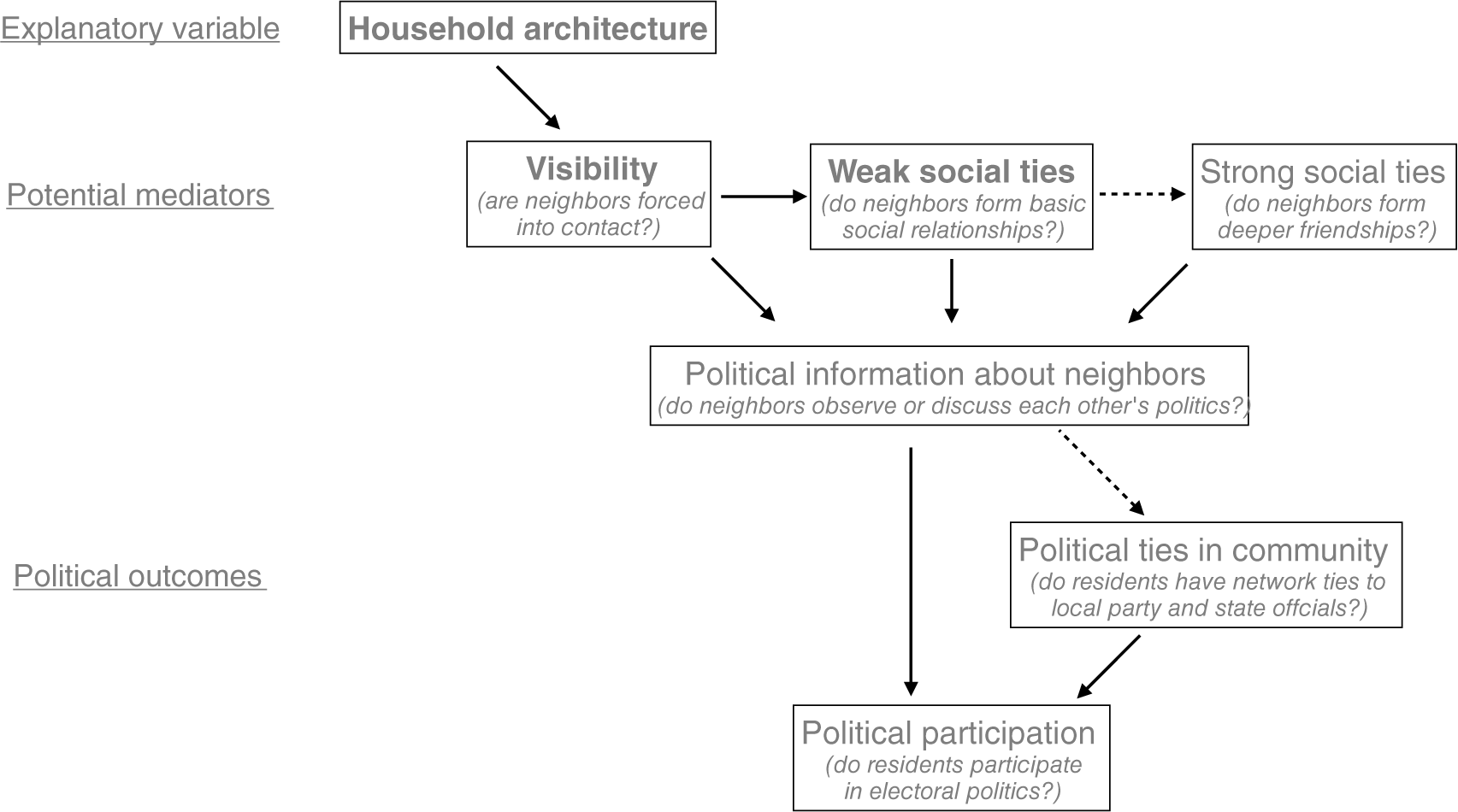
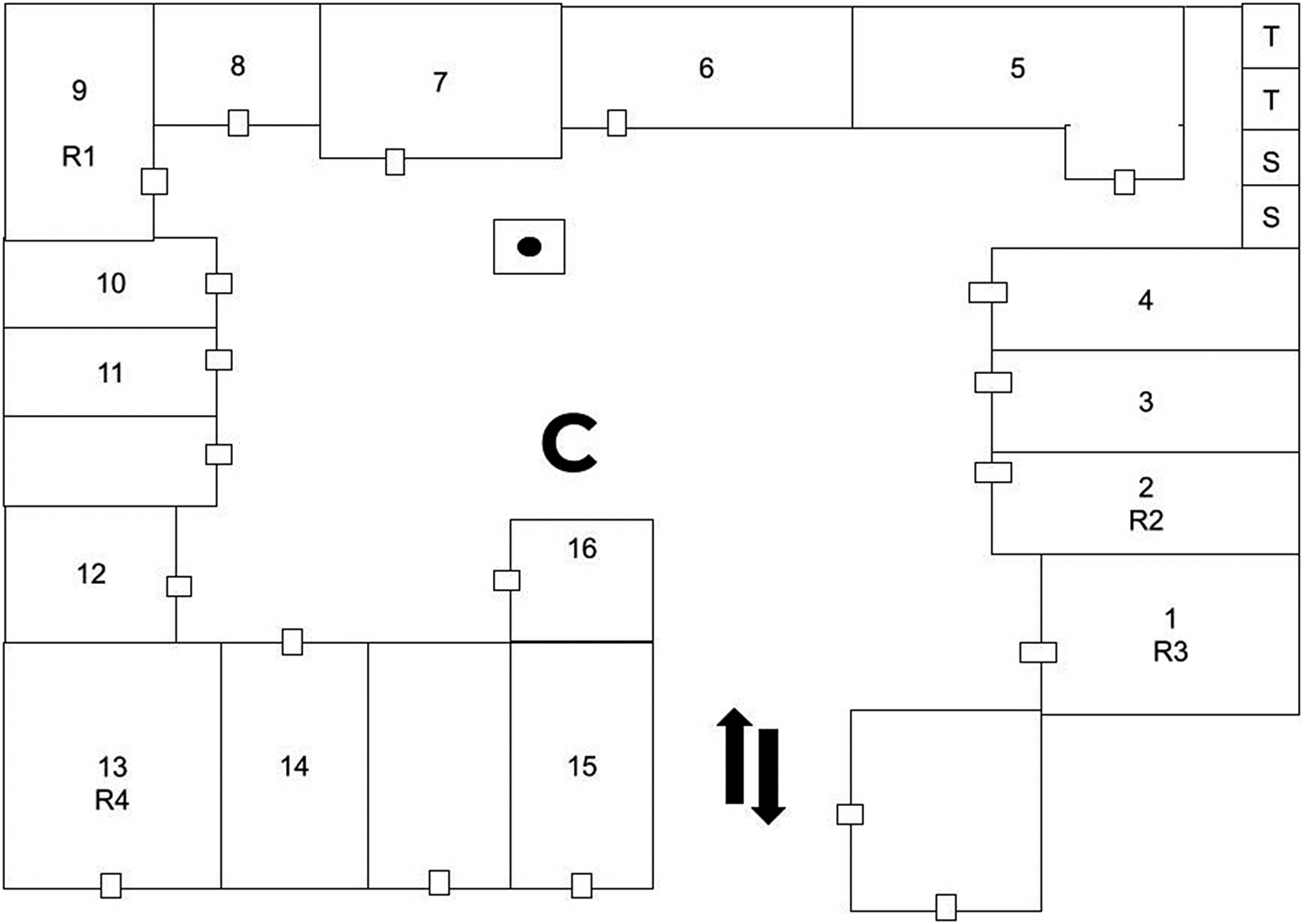
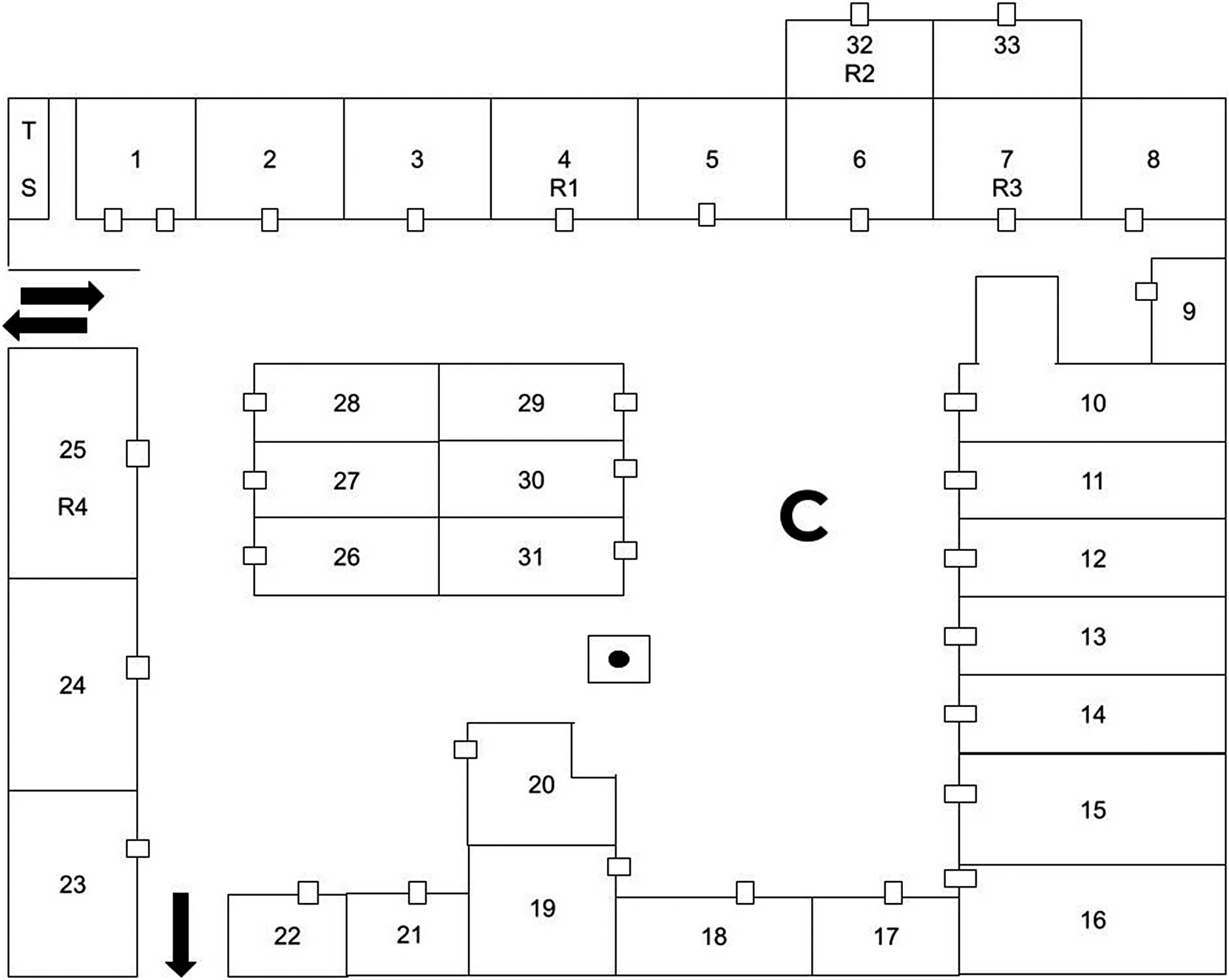
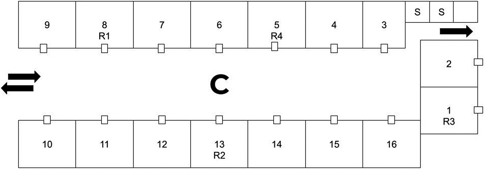
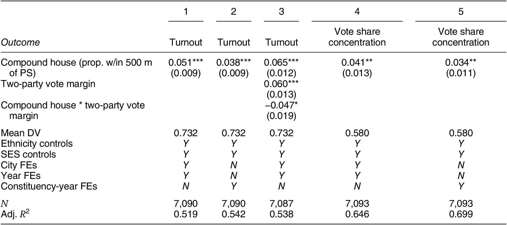
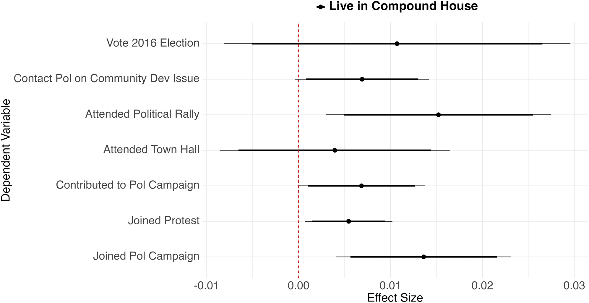
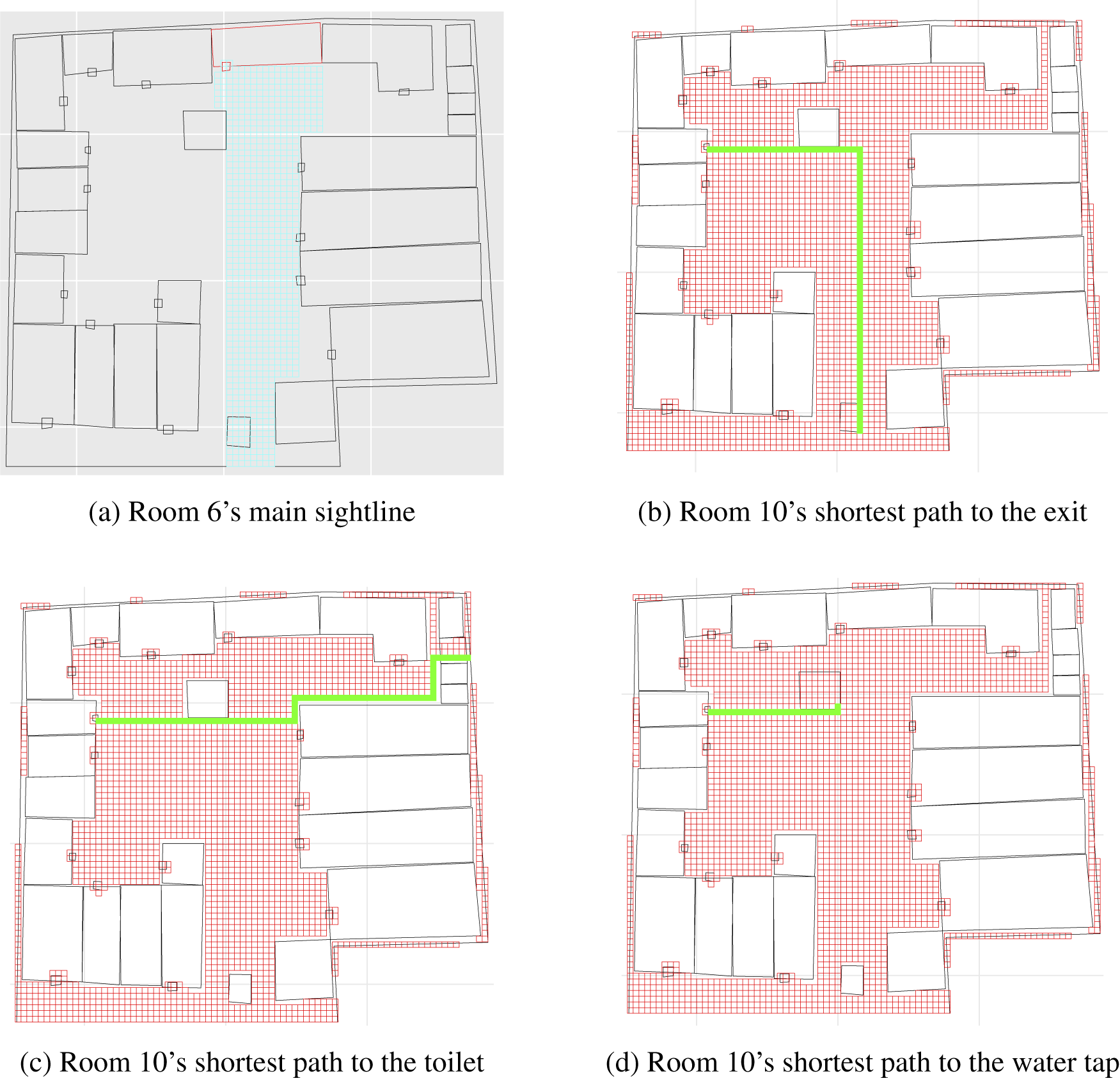
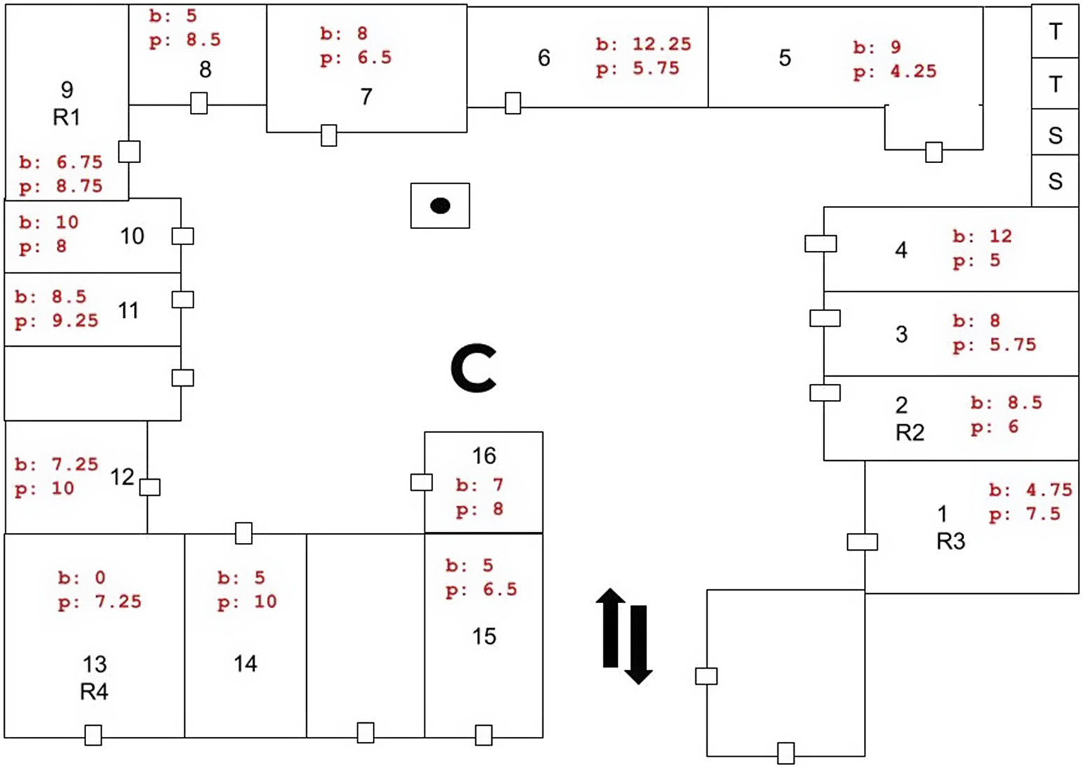
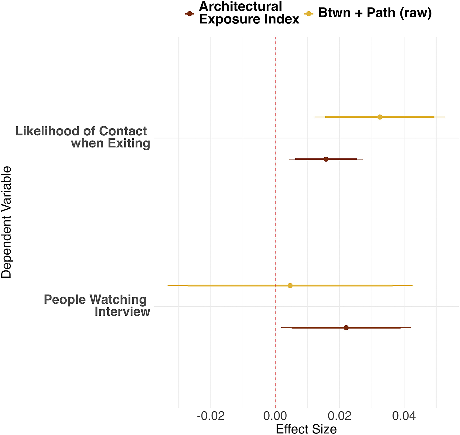
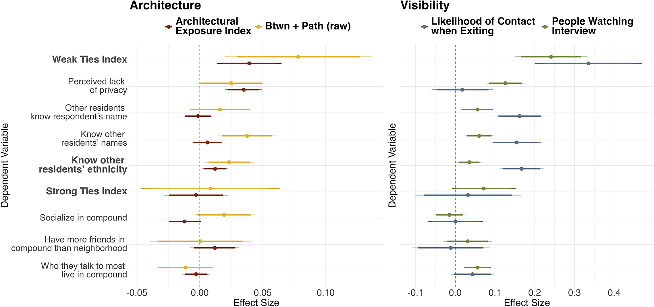
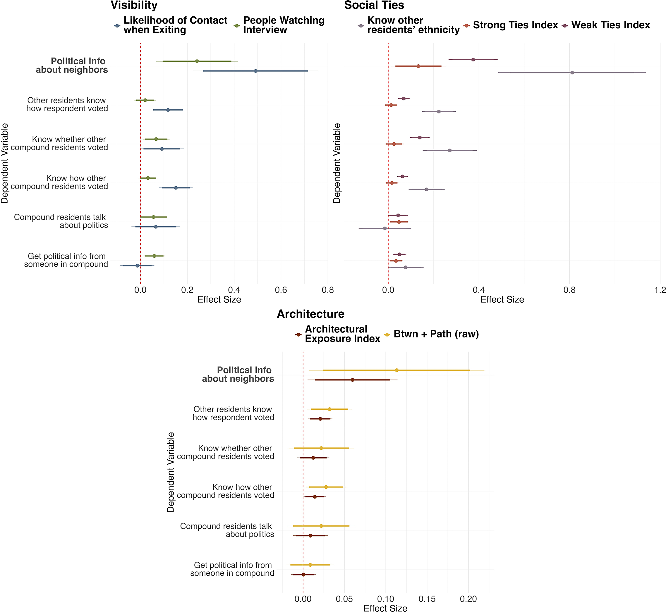
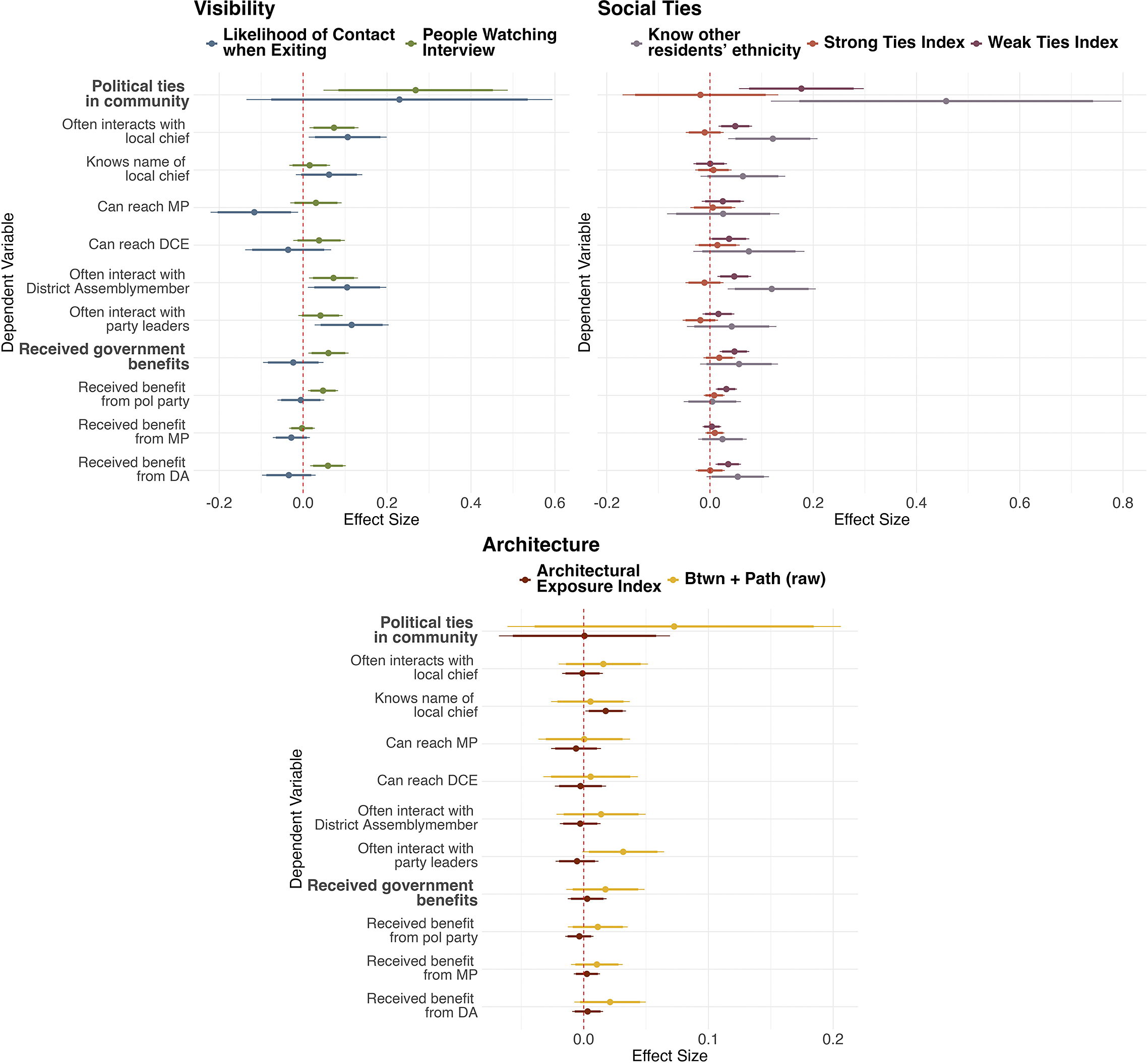


 Open access


Comments
No Comments have been published for this article.