


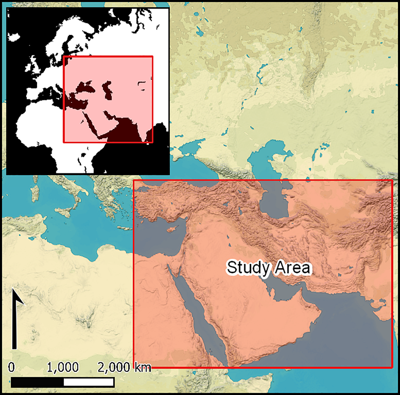
Introduction
Since its declassification in 1995, CORONA spy satellite imagery has become a widely used resource for landscape archaeology and other fields that track environmental and settlement change. The broad utility of this imagery derives from its age, its resolution, its coverage of large swaths of every continent and the ease of digital accessibility through EarthExplorer, the US Geological Survey's (USGS) online repository (e.g. Casana et al. Reference Casana, Cothren and Kalayci2012; Ur Reference Ur2013). The archive of imagery from HEXAGON, the programme that succeeded CORONA, was declassified in 2011. Only recently, in 2020–2022, however, has the imagery became widely available for scanning and download. The research potential of the HEXAGON photographic archive for archaeological research is enormous, yet this potential currently remains largely untapped (Fowler Reference Fowler2016).
While HEXAGON imagery offers many advantages over CORONA imagery, it also has limitations. Advantages include higher spatial resolution, reduced cloud cover, greater geographic coverage, and repeated coverage at regular time intervals (see Table S1 in the online supplementary material (OSM)). The quality and resolution of HEXAGON panoramic photographs is similar to that of commercial satellite imagery available today on platforms such as Google Earth. HEXAGON, however, has the advantage of having been captured four to five decades ago.
With the recent increase in its accessibility, HEXAGON will soon join CORONA as an essential source for a variety of fields that use historical remote sensing data. Here, we aim to reduce further the barriers to accessing and using this imagery. First, we explain the background, technical specifications and declassification/use-history of the HEXAGON photographic archive. We then present four case studies that draw on HEXAGON imagery in order to illustrate how different sites and features appear in the imagery. Finally, we draw on the case studies to discuss the broader benefits and limitations of the archive for archaeological and historical research.
The HEXAGON programme and comparison to CORONA and GAMBIT
In the aftermath of the Second World War, the USA developed aerial and satellite photoreconnaissance programmes for the surveillance of its Cold War enemies. Aerial photography from U2 spy planes (1956–1960, with some later missions) and the GAMBIT KH-7 spy satellite series (1963–1967) were ‘spotter’ programmes, acquiring high-resolution images of specific targets for surveillance purposes. In contrast, the CORONA KH 1–4 spy satellite programmes (1960–1972) collected lower resolution photographic coverage at a broad scale for ‘search’ purposes. On 29 July 1964, the United States Intelligence Board issued a recommendation for the development of a spy satellite programme with “a single capability for search and surveillance with a continuous stereoscopic ground coverage equivalent to KH-4 and a resolution equivalent to KH-7” (National Photographic Interpretation Center 1977: 8 [emphasis added]; Oder et al. Reference Oder, Fitzpatrick and Worthman1992: 65). This so-called “CORONA coverage at GAMBIT resolutions” statement (Perry Reference Perry1973: 103, 108–109) initiated the development of KH-9, code-named HEXAGON, the third, final and most prolific of the film-based US photoreconnaissance satellite programmes.
HEXAGON comprised a series of 20 (19 successful) satellites launched by the National Reconnaissance Office (NRO) between 1971 and 1986, with photographs captured between 1971 and 1984 (Table S2). Early HEXAGON images from missions 1201–1204 provide around a year of interspersed chronological overlap (1971–1972), with the final images coming from the KH-4B CORONA programme, missions 1114–1117. Some core features of HEXAGON were similar to those of the final CORONA satellites (KH-4A, KH-4B). Each HEXAGON satellite, for example, carried a pair of panoramic, stereoscopic cameras. Similarly, the satellites sent film back to Earth in multiple recovery capsules that were parachuted over the Pacific Ocean near Hawai'i and captured in mid-air by Air Force C-130 planes; occasionally, capsules were recovered from the water when air retrieval failed (National Reconnaissance Office 1978: 36–38).
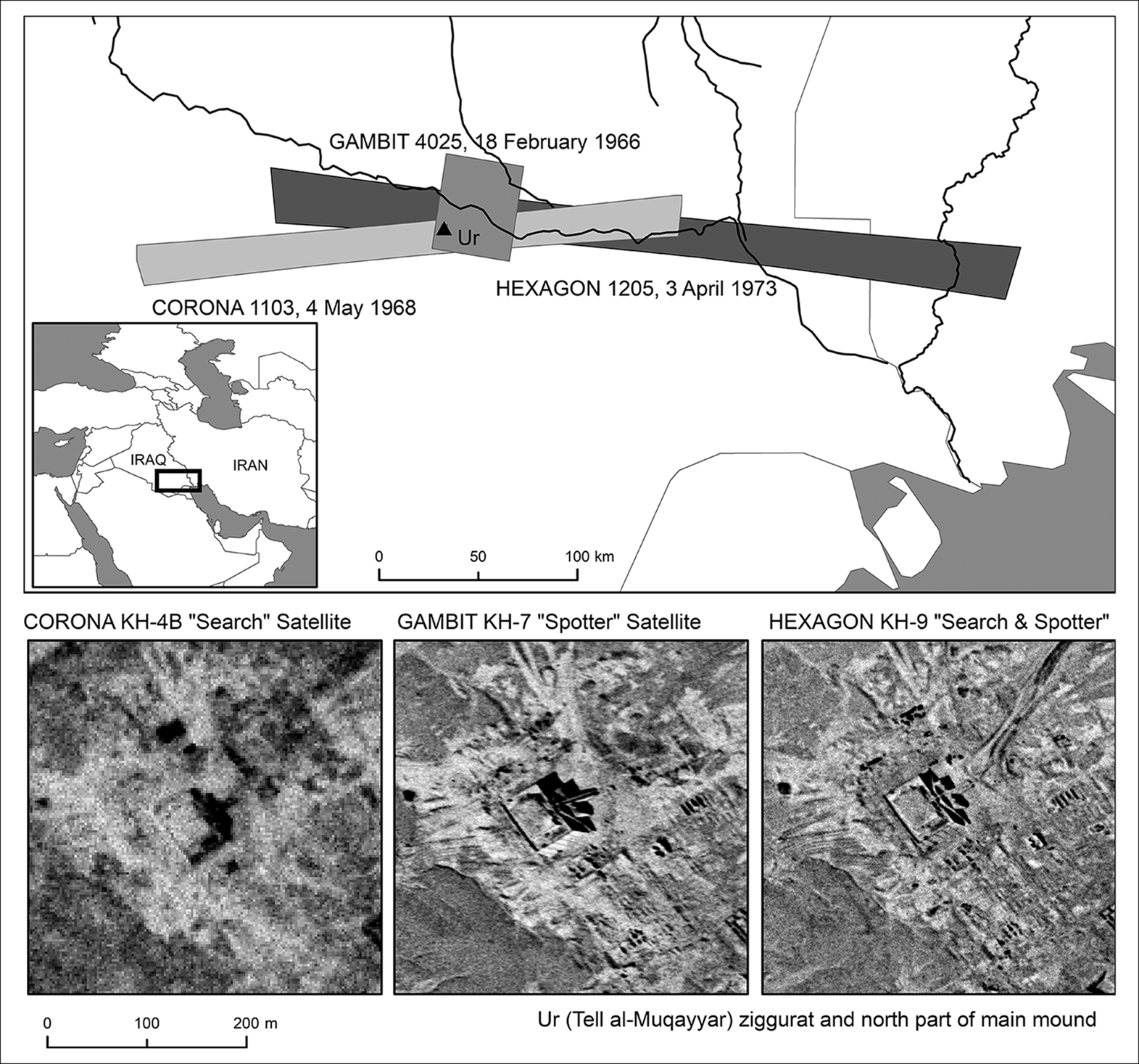
In other ways, HEXAGON superseded the achievements of earlier programmes (Table S1). The first HEXAGON mission, one of the programme's shortest and least productive, nonetheless provided analysts with 930lbs (422kg) of film. By comparison, the first successful CORONA KH-1 mission in 1960 carried only 20lbs (9kg) of film, while GAMBIT-1 missions had carried 45lbs (20kg) and later CORONA flights carried 40lbs (18kg) (Outzen Reference Outzen2012: 28). Typical HEXAGON missions returned approximately 60 000 total frames, compared with approximately 12 000 total frames for each KH-4B CORONA mission (Fowler Reference Fowler2004: 121). In total, HEXAGON's cameras produced approximately two million photographs covering 877 million square miles (2.3 billion square kilometres)—more than double the number of photographs produced by the highest resolution CORONA KH-4A and KH-4B (approximately 700 000). The largest panoramic HEXAGON images cover areas roughly 2.3–4.7 times the size of those covered by the highest resolution KH-4B CORONA image, and at a resolution up to nine times greater (resolution of 1.8m versus 0.6m; ground footprint of approximately 217 × 16km versus variable footprint up to around 685km wide but more commonly approximately 340 × 24km; see Figure 1). Building on the successes of the KH-5 ARGON programme, some HEXAGON missions also carried a frame mapping camera that collected calibrated imagery of the entire globe.
Top) Comparison of panoramic camera footprint size/extent for CORONA, GAMBIT and HEXAGON (example from Nasiriyah, Iraq); bottom) comparison of maximum image resolution near nadir for CORONA, GAMBIT and HEXAGON (example of the ziggurat (temple pyramid) at Ur (Tell al Muqayyar), Iraq) (figure by the authors).
In the 1970s and early 1980s, HEXAGON therefore moved the US government closer to acquiring the high-resolution, cloud-free, on-demand global imaging capabilities that today are routinely provided by commercial satellite companies. HEXAGON satellites had longer mission lives and carried more film-recovery buckets that could return imagery at different times, providing greater ability to ‘task’ the cameras and greater flexibility in accessing the exposed film. HEXAGON's weather-forecasting system for cloud-free mission planning was a vast improvement over that of CORONA and GAMBIT. The success of this system was such that each later HEXAGON mission could provide cloud-free photography for 80–90 per cent of the Asian landmass (Oder et al. Reference Oder, Fitzpatrick and Worthman1992: 139–43). These advances did not come cheaply—HEXAGON was more expensive than any other previous satellite series, and it had a lengthy and troubled development involving both technological problems and bureaucratic struggles between the National Reconnaissance Office and Central Intelligence Agency. The programme, however, was a huge military and intelligence success (Perry Reference Perry1973: 96; Burnett Reference Burnett1982: 152; Outzen Reference Outzen2012: 19–31). The better resolution offered by HEXAGON's panoramic cameras allowed analysts to count troops and see other details not visible in CORONA imagery, as well as to track the Soviet economy through assessing the production of grain, oil, natural gas and heavy metals, as well as nuclear and conventional electricity production (National Photographic Interpretation Center 1977: 32). The HEXAGON mapping camera also provided the global geodetic positioning needed for military operations and weapons deployment (Chester Reference Chester1985: vii). The spatial coverage of imagery from both the panoramic and mapping cameras offered a better view of developing nations than any other spy satellite programme (Oder et al. Reference Oder, Fitzpatrick and Worthman1992: 164; Outzen Reference Outzen2012: 29).
HEXAGON camera systems
HEXAGON missions carried two camera systems. All missions carried a (main) panoramic camera system and missions 1205–1216 additionally carried a lower-resolution mapping camera system.
Mapping camera system (MCS)
The HEXAGON MCS, designed by Itek, produced calibrated frame photography (29 972 frames in total) that covered almost the entire globe except Greenland, Australia and Antarctica. The images date to 1973–1980, have medium spatial resolution (6–9m), and were used both for mapping and for providing metric orientation for panoramic images (Burnett Reference Burnett1982).
The MCS employed a terrain frame camera, with a 12-inch f/6.0 metric lens, that carried approximately 3330 feet of 9.5-inch-wide film (approximately 2000 frames) and a stellar frame camera system that imaged stars above sixth magnitude (National Photographic Interpretation Center 1977: 4–5; National Reconnaissance Office 1978: 79 & 92–95). Each terrain frame covered approximately 130 × 260km (Fowler Reference Fowler2004: 123). The terrain camera operated in one of two modes, bilap (missions 1214–1216) or trilap (missions 1205–1216), resulting in images with overlaps of 55–70 per cent (Burnett Reference Burnett1982: fig. 3–2). Terrain images from the MCS can thus be used as stereo pairs for the generation of historical digital elevation models (DEMs) (Dehecq et al. Reference Dehecq2020).
Panoramic (main) camera system (PCS)
The PCS, designed by Perkin Elmer, was carried by every mission and produced more than 60 000 photos per mission. PCS images are high resolution, with some exceeding 0.6m at nadir. Most HEXAGON photography is black and white, but many missions also used natural colour and false colour infrared film (see Table S2 and National Reconnaissance Office 1978: 70–71).
The PCS consisted of two independently controllable stereoscopic cameras, with 60-inch (1.8m) focal length f/3.0 folded Wright optical systems, using 6.6-inch-wide film (National Reconnaissance Office 1978: 20; Burnett Reference Burnett1982: 1–25). Missions 1217–1219 additionally carried a stellar solid-state camera (S3) that allowed panoramic imagery to be geometrically corrected for mapping purposes (Burnett Reference Burnett1982: 2–1; Chester Reference Chester1985: 64). As with the PCS designed for CORONA, the cameras rotated as they swept back and forth—a motion that intelligence officials called ‘mowing the lawn’. The satellites were configured with a forward-looking ‘A’ camera on the port side and an aft-looking ‘B’ camera on the starboard side, with a stereo convergence angle of 20° (Outzen Reference Outzen2012: 24). The cameras could be operated in 16 different modes defined by one of four scan widths (30, 60, 90 and 120°) and one of seven scan centre placements (0, ±15, ±30 and ±45°). Image frames are 6in wide; length varies from 0.79m (2.6ft) for a 30° scan to 3.2m (10.5ft) for a 120° scan (National Photographic Interpretation Center 1977: 2; National Reconnaissance Office 1978: 20). A 120° scan (rarely used) could cover an area approximately 685km wide. Table S2 shows the average resolution for each mission.
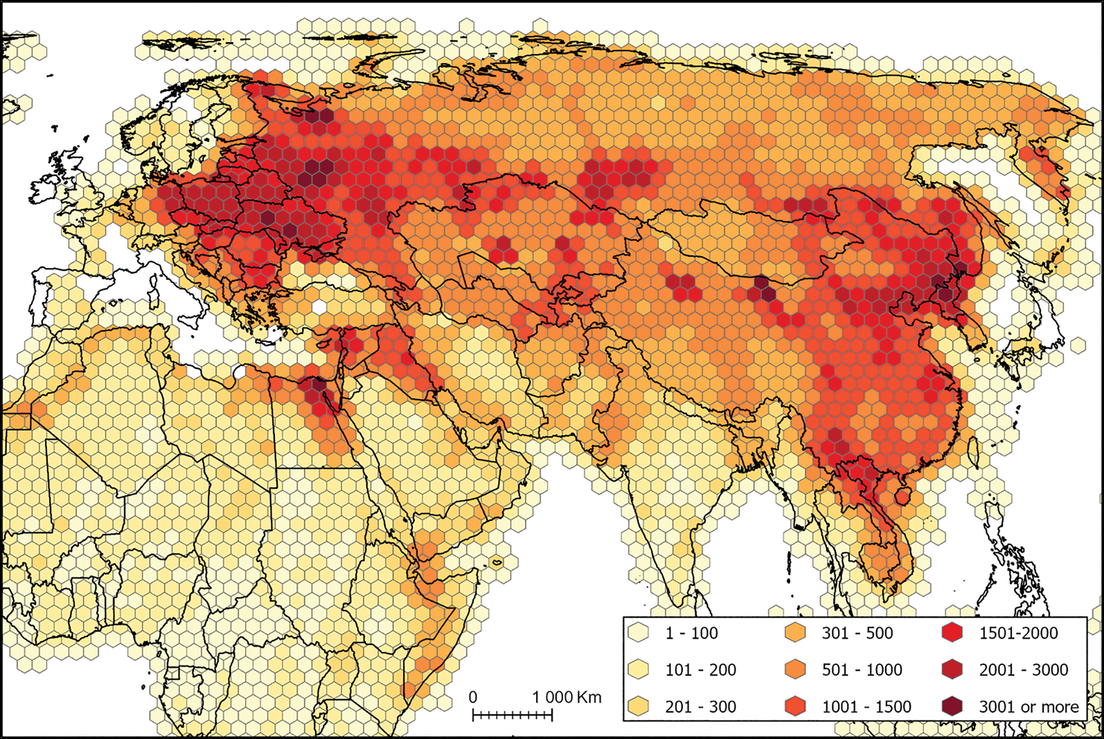
HEXAGON's repeated photographic coverage was programmed on a schedule to allow analysts to both search for infrastructural or other changes and to carry out historical studies of newly identified targets or activities (National Photographic Interpretation Center 1977: 52 & 60). The programme aimed to photograph clusters of high-priority targets every two months; lines of communication targets every four months; “built-up” and other target areas every six months; other lines of communication every nine months; “undeveloped areas” every 12 months; “remote areas” every 18 months; and areas considered “topographically unsuitable” for infrastructure and inhabitation every 24 months (National Photographic Interpretation Center 1977: fig. 3.2; Oder et al. Reference Oder, Fitzpatrick and Worthman1992: 148–51). Figure 2, a hotspot map, reconstructs the different priority target areas of this standing search programme.
HEXAGON coverage of North Africa and Eurasia (an interactive web scene of global coverage is available at: https://arcg.is/aireX) (figure by the authors).
Declassification, acquisition and use of HEXAGON imagery
The images from the two camera systems have different declassification and public access histories.
Mapping camera system
HEXAGON MCS film was declassified and transferred to the National Archives and Records Administration (NARA) on 20 September 2002, in a continuation of the procedures established by Executive Order 12951 in February 1995 to declassify CORONA imagery. The HEXAGON declassification covered approximately 29 000 images, excluding some 100 images over Israel (Surazakov & Aizen Reference Surazakov and Aizen2010: 604). Following declassification, copies of the film were transferred to the US Geological Survey's Earth Resources Observation Systems (EROS) Center. Since that time, MCS film has been available for digital scanning and download via EarthExplorer (Declass2 collection), and the MCS frames have been widely employed in research on climate and environmental change. Time series of DEMs produced from mapping camera imagery have become a common tool in glaciology (e.g. Mauer et al. Reference Mauer, Schaefer, Rupper and Corley2019) and other fields that track changes in tectonic deformation, glacial lakes, tree lines and shorelines.
Panoramic camera system
PCS film was declassified on 17 September 2011 to commemorate the fiftieth anniversary of the National Reconnaissance Office. Public access, however, has been considerably more difficult than for MCS images. Until 2020, the public could only access PCS film in hard copy via the National Archives and Records Administration, and no spatial index was available. Researchers had to place advance orders for film rolls to be delivered from the ‘Ice Cube’ storage facility in Lenexa, Kansas, to the National Archives and Records Administration Aerial Film Reading Room in Greenbelt, Maryland. They were also required to use their own macro lens photography equipment to reproduce the negatives, using methods similar to those described for (also unscanned and unindexed) U2 aerial film (see Hammer & Ur Reference Hammer and Ur2019). In 2019, over 14 000 rolls (>670 000 scenes) of HEXAGON film—black-and-white copies of the originals held by the National Archives and Records Administration—were transferred to the Earth Resources Observation Systems Center for ingestion into EarthExplorer (www.usgs.gov). In 2020, the US Geological Survey gradually began to make HEXAGON film available for on-demand scanning and download (Declass3 collection), beginning with the earlier missions. This process is ongoing in 2022. The low cost—only US$30 per scene for unscanned imagery—equates to less than US$0.002/km2 for those HEXAGON scenes with the most extensive coverage. After scanning, files become freely available to all users. In requesting the scanning of imagery the user should be sure to choose the 7μm (3600 dpi) option in order to approximate the full resolution of the images. The US Geological Survey delivers each scene as a series of up to 14 overlapping files (labelled with letters a–n, depending on the length of the negative; up to 725 MB per file). As access has only recently broadened, HEXAGON PCS images have not yet found major research applications.
Georeferencing
The US Geological Survey distributes HEXAGON PCS products as raw TIFF files that contain significant spatial distortion. This distortion is most extreme toward image edges and comes from multiple sources—related to the imaging geometry of the camera, the curvature of the Earth, topographic relief, and the motion of the satellite during exposure of the film—that have been well described for CORONA imagery, which was also captured by panoramic cameras on elongated film strips (Casana et al. Reference Casana, Cothren and Kalayci2012). Users must undertake georeferencing in order to incorporate HEXAGON images into Geographical Information Systems. The US Geological Survey makes approximate footprint files and low-resolution preview scans available for download, and these can aid users in georeferencing.
For the case studies presented below, we used ESRI ArcGIS to georeference each scan covering a segment of a long panoramic image, and mosaicked them to reconstruct full scenes. Our ground control points (>15/scan) were drawn from modern DigitalGlobe imagery, accessed via the ESRI basemap. For areas close to nadir with relatively flat topography, only second-order polynomial transformations were required, but third-order polynomial transformations often produced better results for mountainous regions and areas falling at the image's edges. In georeferencing HEXAGON images, users must overcome the same challenges facing those who use CORONA imagery. In particular, the identification of good control points evenly spread across the scan can be difficult, given changes during the decades separating HEXAGON and DigitalGlobe imagery.
The simple georeferencing process that we followed is sufficient for visual analysis of the imagery over modestly sized areas. Researchers wishing to make use of the stereo capabilities of HEXAGON, or needing to process large numbers of scenes, should pursue other methods of orthorectification that take into account terrain, camera parameters and imaging geometry, following processes developed by the CORONA Atlas Project (Casana & Cothren Reference Casana and Cothren2008; Casana et al. Reference Casana, Cothren and Kalayci2012; Casana Reference Casana2020).
Archaeological case studies
With the recent declassification of PCS imagery, HEXAGON now has great potential for research in fields such as archaeology and history. Some archaeologists have built on methods developed in the geosciences to use MCS images for the construction of historical DEMs, visual analysis of features and assessment of landscape change (e.g. Fowler Reference Fowler2004; Castrianni et al. Reference Castrianni, di Giacomo, Ditaranto and Scardozzi2010; Scardozzi Reference Scardozzi2010; Walstra et al. Reference Walstra, Heyvaert and Verkinderen2010; Sevara et al. Reference Sevara, Verhoeven, Doneus and Draganits2018). Generally, however, MCS images do not resolve most archaeological and historical features. Archaeologists and historians will therefore find PCS images of much greater use. Indeed, PCS images have already been used by Near Eastern archaeologists to study ancient irrigation systems and settlement patterns (e.g. Ur & Reade Reference Ur and Reade2015; Nováček et al. Reference Nováček2016; Hammer Reference Hammer and Rost2022; Ur et al. Reference Ur2021), and to aid the interpretation of archaeological geophysics data by distinguishing between recent and potentially ancient features (Herrmann & Hammer Reference Herrmann and Hammer2019).
Here, we discuss archaeological applications of PCS images through case studies drawn from our own research, illustrating a number of advantages over CORONA, as well as limitations of the HEXAGON archive.
Case study 1: hollow ways in Early Bronze Age north-eastern Syria
One of the earliest applications of CORONA photography was the study of the hollow way route systems of northern Mesopotamia (Ur Reference Ur2003). Over 6000km of trackways were documented across the plains of north-eastern Syria, mostly datable by association to the Early Bronze Age (c. 2600–2000 BC), a time of urbanisation and intensive land use. Despite the centralised political authority of the time, the resulting landscape is best interpreted as emergent or self-organised, stemming from local patterns of human and animal movements between settlements and fields (Ur Reference Ur, Snead, Erickson and Darling2009).
The CORONA dataset behind the study of Early Bronze Age hollow ways was drawn from three missions between 1967 and 1972. The visibility of hollow way features was heavily dependent on ground conditions; reconstructions were often partial and required images from more than one mission. HEXAGON therefore offered the possibility of expanding the CORONA dataset on two accounts. First, the greater film capacity of HEXAGON meant that northern Syria was revisited more frequently than was possible with CORONA and, second, the larger number of resulting images might mean that coverage during optimal seasons (late autumn to early spring) would be more available.
In this case, HEXAGON provided only a slight improvement over the capabilities of CORONA. Its greater spatial resolution was unnecessary for identification of landscape features that routinely measure more than 100m in width. Furthermore, the later dates of image acquisition (in some missions, a decade after CORONA) meant that taphonomic processes had damaged or removed surface features.
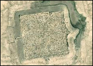
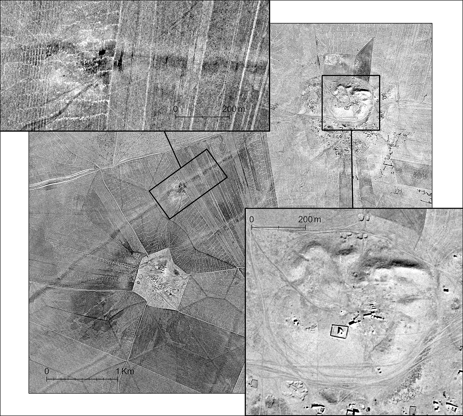
HEXAGON therefore offered confirmation of features already identified via CORONA and a marginal expansion of the original landscape dataset. In this case, the real advantage of HEXAGON imagery related not to landscape features but, rather, to settlement sites. The Early Bronze Age settlements of this region have eroded into prominent mounds (tells), the topography of which can include clues to settlement structure and history. In this realm, HEXAGON rivals aerial photography in its ability to resolve the subtle bumps and depressions that might reveal ancient streets, gates or neighbourhoods (Figure 3). Many such site features have been damaged in recent years, as tells have become military positions in the ongoing Syrian civil war.
HEXAGON photograph of the Early Bronze Age city of Hamoukar (1204-300451, acquired 17 November 1972), showing details of the main mound of the site and the main south-west hollow way feature (interactive web map is available at: https://arcg.is/0nimDL) (figure by the authors).
Case study 2: ethnohistorical study of mobile pastoralist campsites in north-western Iran
Mobile pastoralists have been important components of ancient and pre-modern society in the Middle East, but their archaeological traces are difficult to find and study, especially with remote sensing. A project to study imperial settlement and irrigation in the Sasanian Empire led to the unexpected identification of an extensive landscape of pastoral campsites in the Mughan Steppe of north-western Iran (Alizadeh & Ur Reference Alizadeh and Ur2007). These campsites were recognised as a pattern of light circles or ovals distributed across the uplands, around a lower irrigated zone. Ground survey and historical and ethnographic accounts (Tapper Reference Tapper1979, Reference Tapper1997) indicate that these marked the former winter campsites of the Shahsevan confederacy and their predecessors over the last few centuries. With confirmation of this archaeological signature, campsites could then be recognised via CORONA imagery across the Steppe at a density of nearly one site per km2. Mughan proved to be an excellent example of the historical fluctuation between intensive agriculture under a centralised state and extensive pastoralism under local control by a tribal confederacy.
Unlike the case of the Early Bronze Age hollow ways presented above, HEXAGON imagery has greatly enhanced the study of this pastoralist landscape. The Mughan Steppe was on the border between US-allied Iran and the Azerbaijan SSR—a major Cold War frontier. HEXAGON's temporal coverage provides photographs taken under ideal environmental conditions for campsite visibility, including months of the year when the remaining un-sedentarised Shahsevan were in residence.
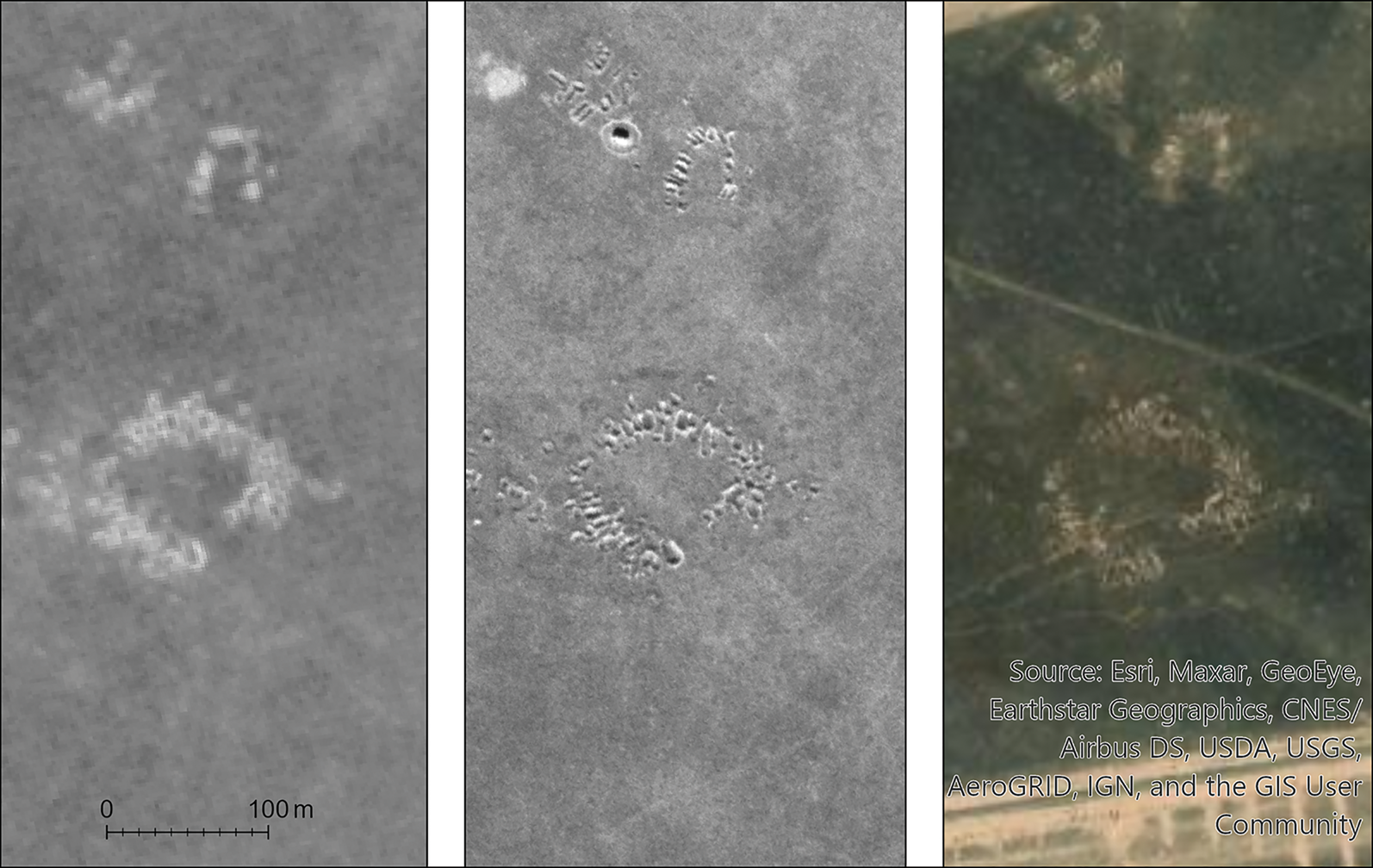
The small scale of the campsite features means that HEXAGON's high resolution is critical for accurate identification. In CORONA imagery, some features were ambiguous and therefore were not recorded as part of the analysis. Most of these are easily confirmed or rejected using HEXAGON imagery acquired only a few years later. Furthermore, the enhanced resolution allows shadows to be resolved, so it is possible to distinguish between excavated and mounded features and to infer horizontal stratigraphy from former campsites in various stages of decay (Figure 4). The distinctive yurt-style tent of the Shahsevan could also be detected, and future studies using winter HEXAGON imagery could produce historical population estimates.
Former campsites on the Mughan Steppe, shown on CORONA (left; 1110-1057DA111, acquired 24 May 1970), HEXAGON (centre; 1207-200204A016, acquired 10 December 1973) and modern commercial imagery (right; Esri base imagery) (interactive web map is available at: https://www.arcgis.com/apps/dashboards/77b9839ff30846e5b546f5387cb12ad1) (figure by the authors).
Nonetheless, the later acquisition dates for Mughan HEXAGON imagery lead to a major disadvantage. In the late 1960s, when CORONA flew over the Steppe, the Iranian government was constructing a large irrigation system that would convert much of the best pasture into cropland. By the 1970s, when the HEXAGON imagery was acquired, the irrigation scheme was complete. Indeed, scenes reveal how Shahsevan campsites cluster against the canal that separated the remaining pasturelands from the now-irrigated fields. Nearly all of the Shahsevan winter pastures were subsequently brought under cultivation, and in the process, the archaeological traces of the campsites of their ancestors have been erased.
Case study 3: Iron Age irrigation in Naxçıvan, Azerbaijan
In the Late Bronze Age and Early–Middle Iron Age (c. 1500–600 BC), the settlement and burial patterns of communities in South Caucasia were based around hilltop forts and fortresses. Until recently, the study of the landscapes around these fortresses and cemeteries was hampered due both to the focus of researchers (Hammer Reference Hammer2014; Herrmann & Hammer Reference Herrmann and Hammer2019) and to a lack of access to historical imagery that could aid identification of features like the irrigation systems and road networks investigated elsewhere in the Middle East.
The declassification of CORONA transformed the field of landscape archaeology in arid, sparsely vegetated areas such as the Middle East, but its greatest impacts have been confined to ancient features in lowland, irrigated alluvial plains and rain-fed steppe environments, such as those seen in case studies 1 and 2. CORONA coverage is sparse, of poor quality, and sometimes non-existent for other environments. Notable for Middle Eastern archaeology is the lack of CORONA coverage across the highlands and plateaus of Central Turkey and the cloudy, often lower-resolution coverage of parts of formerly Soviet South Caucasia (modern Azerbaijan, Armenia and Georgia).
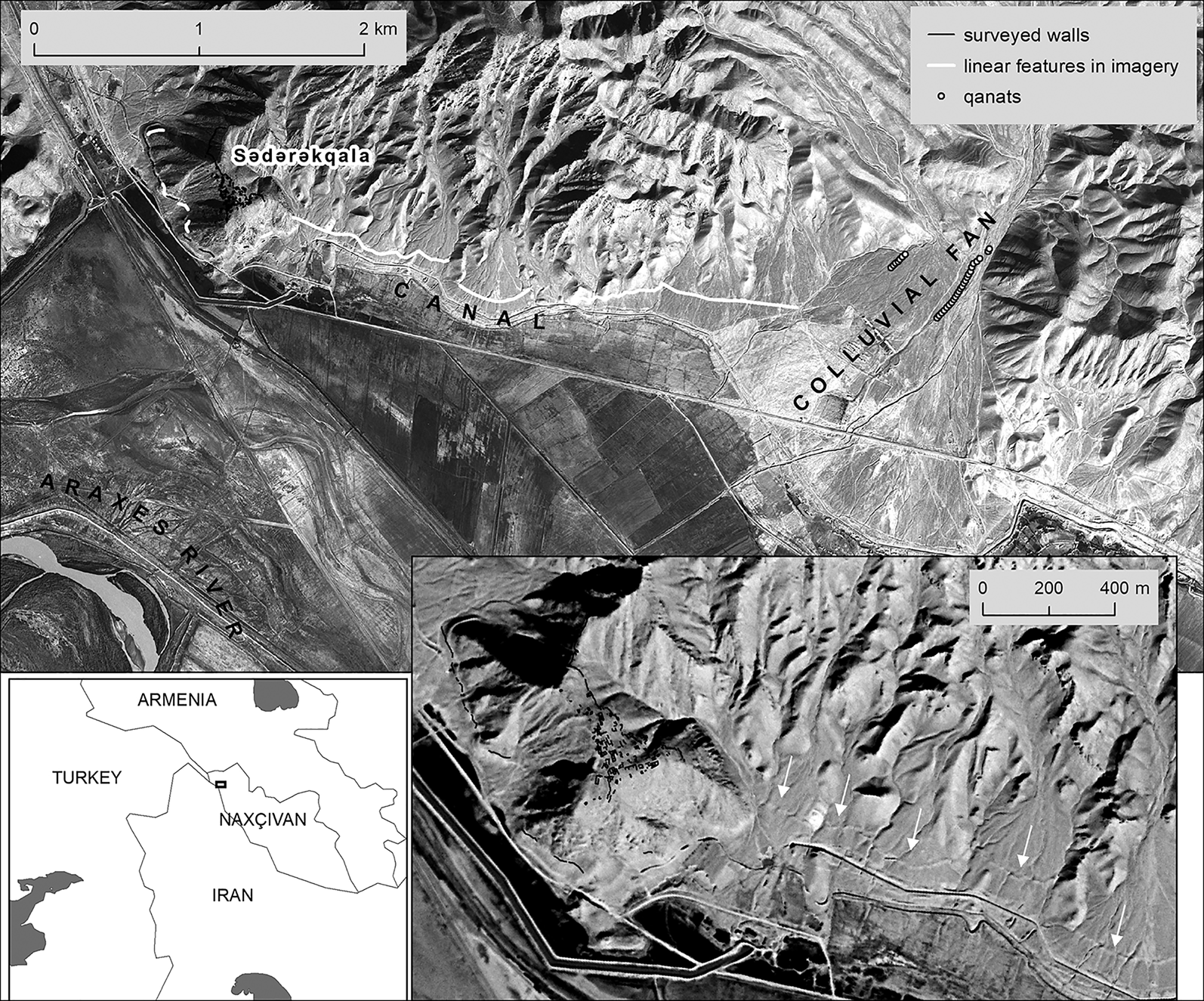
The availability of HEXAGON imagery should improve significantly the ability of archaeologists to detect landscape features associated with Bronze and Iron Age fortresses. HEXAGON has been crucial for revealing the remains of an irrigation system in the vicinity of the Iron Age fortress of Sədərəkqala, in Naxçıvan, Azerbaijan (Hammer Reference Hammer and Rost2022). The hilltop upon which Sədərəkqala sits is surrounded on three sides by a massive stone wall that archaeologists previously suggested was a sizeable irrigation canal constructed by Urartu, an empire that expanded into this region in the Middle Iron Age (c. 800–600 BC) (Belli & Sevin Reference Belli and Sevin1999: 58–61). HEXAGON imagery combined with topographic analysis suggests that the approximately 500m-long standing walls were originally connected to a linear feature that appears to be a canal (Figure 5). The canal stretches approximately 3.5km from a colluvial fan to the south-eastern edge of Sədərəkqala's hilltop, following the topography of the hills that border the plain, at roughly the 815m asl contour.
HEXAGON image of Iron Age (?) Sədərəkqala canal, Naxçıvan, Azerbaijan (1204-300342, acquired 13 November 1972). Inset map shows the study location (interactive web map is available at: https://arcg.is/PfCyP0) (figure by the authors).
The linear feature in the HEXAGON imagery lends considerable support to the hypothesis that the lower wall was part of a former canal but suggests that this canal was of a very different nature than previously described. With the aid of HEXAGON imagery, what was initially interpreted as a canal of significant length (25–30km) drawing water from distant perennial rivers (the Araxes or the Arpa (Belli & Sevin Reference Belli and Sevin1999)) now appears to have been a much more modest construction (approximately 3.5km in length) that drew from nearby groundwater resources in a colluvial fan. Such a construction is more likely to have been within the labour capacity of a local-scale polity and not to have required the intervention of an outside group such as Urartu (Hammer Reference Hammer and Rost2022).
This feature cannot be seen on the available CORONA imagery due to poor resolution and clouds, and is invisible today due to the construction of the modern canal system sometime after 1980, which involved intensive levelling of the area. Thus, the date and resolution of the HEXAGON imagery have been essential for the correct identification of the irrigation canal. The date of the imagery, however, is still too late to capture some features of interest. Construction of a cement factory at the east end of Sədərəkqala's mountain sometime before 1972 resulted in major changes to the local topography in a location where a settlement related to the fortress was probably located (Hammer Reference Hammer and Rost2022).
Although HEXAGON provides excellent coverage of highland areas that are poorly covered by CORONA, showing archaeological traces that have since disappeared, it was too late to capture the landscape before some areas were dramatically transformed by Soviet land-amelioration programmes.
Case study 4: cultural heritage destruction in Balkh, Afghanistan
In areas of active conflict such as the Middle East, Central Asia and North Africa, the analysis of spatial and temporal patterns in looting and destruction at archaeological sites using time series of sub-metre-resolution commercial satellite imagery has become an important methodology in the field of cultural heritage management (Stone Reference Stone2008; Parcak et al. Reference Parcak2016; Casana & Laugier Reference Casana and Laugier2017; Rayne et al. Reference Rayne2017). Scholars and analysts, however, have faced several barriers to providing a longer-term historical perspective on cultural heritage preservation: high-resolution commercial satellite imagery coverage only began in the early 2000s and frequent re-imaging did not occur until over 10 years later for many non-urban locales, limiting the available archive. Furthermore, commercial satellite imagery is expensive, putting time-series analysis beyond the budget of most projects. Older, freely available imagery from multi-spectral satellite programmes such as Landsat and ASTER have provided time series of images crucial for the study of environmental and landscape change, but the resolution of these images (15–30m) is too low to be of use for archaeological and cultural heritage applications. KH-4A and KH-4B CORONA provide a historical time series for the late 1960s and early 1970s, but the chronological range is narrow, the repeated coverage was infrequent for many areas, and, moreover, CORONA imagery typically does not resolve small features that track changes in cultural heritage preservation.
HEXAGON's resolution is often adequate to resolve looters’ pits, trenches, the robbery or reuse of brick or stone and other indications of damage to heritage sites. It therefore offers a better historical baseline for damage assessments than other imagery sources. Further, HEXAGON's regular time intervals, spaced over more than a decade, and repeated coverage at sub-metre resolution provide the opportunity to extend cultural heritage analyses further back in time. Such analyses are particularly important for places which have long histories of conflict and heritage destruction that began long before the advent of high-resolution commercial satellite imagery.
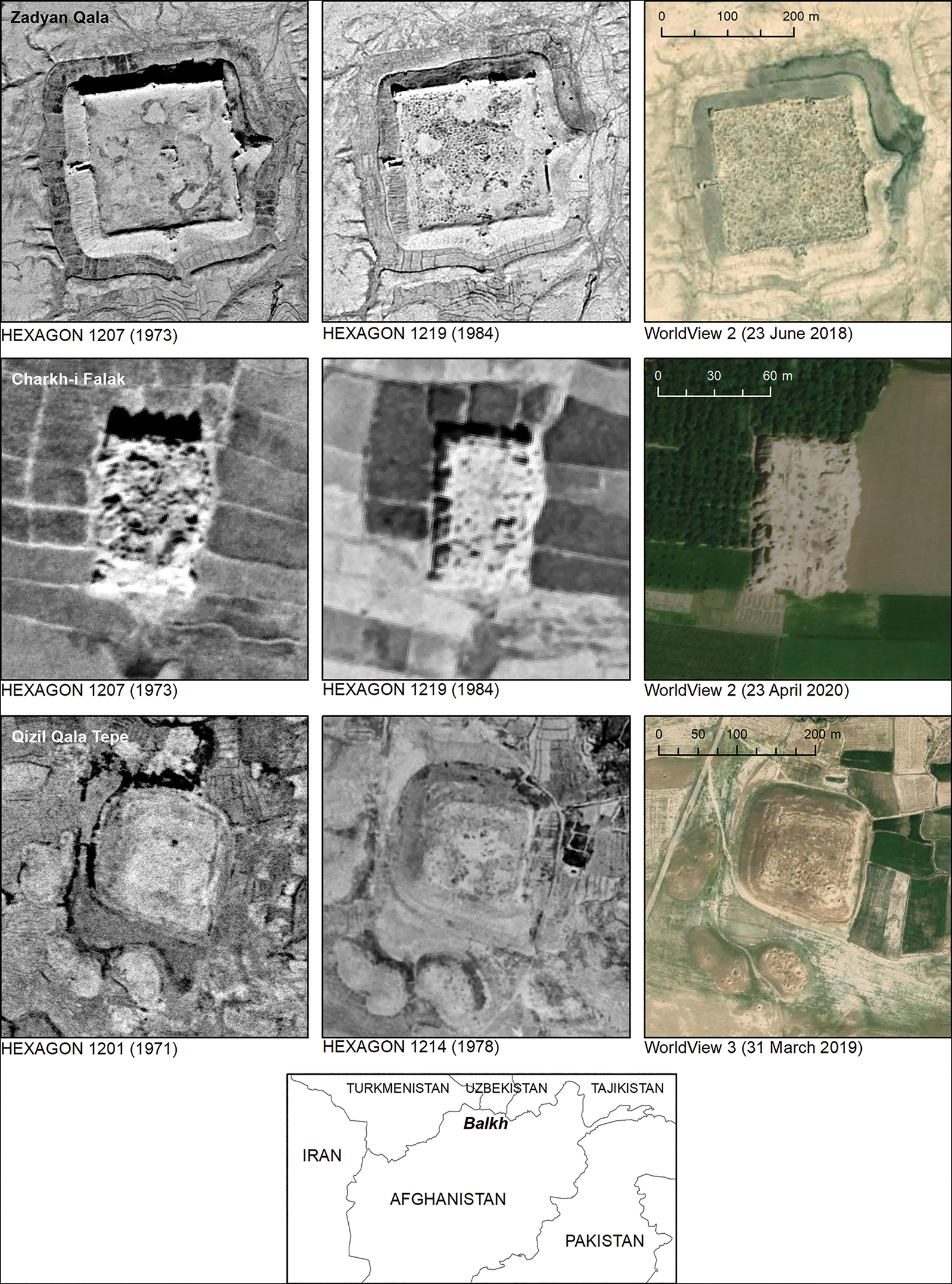
A prime example of such a place is Afghanistan, which experienced significant but undocumented levels of looting and site destruction in the 1970s and 1980s (Hammer et al. Reference Hammer, Seifried, Franklin and Lauricella2018). HEXAGON's temporal coverage can trace site preservation during the turbulent end of the monarchy period and on either side of the 1979 Soviet invasion. In a preliminary study, HEXAGON has been useful for tracking the beginning and acceleration of large-scale looting in the Balkh Oasis of northern Afghanistan—one of the richest archaeological regions of the country and an area that has suffered persistent looting to the present day (Hammer et al. Reference Hammer, Seifried, Franklin and Lauricella2018). HEXAGON imagery series show the massive increase in the number and density of looting pits from the early 1970s to the early 1980s at several archaeological sites in the Oasis, including Zadyan Qala, Charkh-i Falak and Qizil Qala Tepe (Figure 6). Notably, the most significant increases in looting at large sites like Zadyan Qala occurred just prior to and following the Soviet invasion, by the time of the 1978 and 1984 HEXAGON images. Some smaller sites that are located close to modern population centres, such as Charkh-i Falak, had already been extensively looted by the early 1970s. A detailed spatial and temporal analysis of these looting patterns, considering both large, well-known sites and smaller, previously undocumented ones across the Oasis, is the subject of an ongoing study by the lead author and colleagues.
Time series of HEXAGON images, 1971–1984, showing the increasing extent of looting at Zadyan Qala, Charkh-i Falak and Qizil Qala Tepe, Balkh Oasis, Afghanistan. Inset map shows the study location (interactive web map of Zadyan Qala is available at: https://arcg.is/1bGqTa) (figure by the authors).
HEXAGON provides an important resource for time-series analysis of change in archaeological site preservation. Such analysis is not possible with available CORONA imagery. Similar methods could be profitably applied to study not only cultural heritage issues, but also seasonal and temporal changes in the landscape and taphonomy of archaeological sites and features.
Conclusions
The US Geological Survey's recent instatement of a scan-and-download programme for HEXAGON panoramic imagery has made an enormous set of archival imagery accessible to the global public. Archaeologists, anthropologists and historians should capitalise on this new resource. We hope that the information and case studies presented here will increase awareness of the new availability of this historical imagery and facilitate its broader use by researchers. Human activity and development constantly erase or obscure traces of the past, so older imagery is often more useful to archaeologists. The later date of HEXAGON scenes—captured up to 17 years after CORONA KH4A-KH4B—can render them less valuable for mapping historical and archaeological features. As case study 1 shows, researchers working in areas with the best, high-resolution CORONA coverage may not benefit greatly from HEXAGON imagery. As our other three case studies illustrate, however, HEXAGON panoramic imagery can have a number of important advantages over earlier CORONA imagery, especially in areas where CORONA coverage was non-existent or non-ideal, and in research contexts requiring the mapping of small or ephemeral features, or enough repeated coverage to enable time-series and seasonal analyses.
As with KH-4 CORONA (Casana & Cothren Reference Casana and Cothren2008; Casana et al. Reference Casana, Cothren and Kalayci2012), the stereo pairs of panoramic images offer future possibilities to create high-resolution historical DEMs. All these characteristics of HEXAGON panoramic imagery could yield important data for many disciplines that use historical remote sensing.
Funding statement
Emily Hammer thanks the Naxçıvan Archaeological Project, funded by the US National Science Foundation (BCS-1430404, co-PIs Lauren Ristvet, Emily Hammer and Hilary Gopnik) and the National Geographic Society (9367-13, PI Emily Hammer), as well as collaborator Vəli Baxşəliyev for the fieldwork summarised in support of the imagery analysis in case study 3. Hammer also thanks the Afghan Heritage Mapping Project of the Oriental Institute of the University of Chicago, funded by the US State Department (Grant SAF 200-15-CA014, PI Gil Stein), for inspiration for the imagery analysis in case study 4. Jason Ur acknowledges the collaboration of Karim Alizadeh in the fieldwork summarised in case study 2.
Supplementary material
To view supplementary material for this article, please visit https://doi.org/10.15184/aqy.2022.22


 Open access