


Introduction
Recent research strengthens the evidence that populations of the Early Bronze Age (3300/3050–2500/2200 BCE) Yamna (Yamnaya) culture spread out of the North Pontic Steppe in the late fourth millennium BCE, transforming the genetic and social landscape of Europe (Lazaridis et al. Reference Lazaridis2025; Nikitin et al. Reference Nikitin2025). As Yamna burial mounds (kurgans) often overlie the ritual sites of the Eneolithic (4500/4300–3300/3050 BCE) steppe inhabitants (Rassamakin Reference Rassamakin and Muller-Celka2012), interaction with the tangible heritage of their predecessors seems evident. We term this pattern the ‘continuity of sacred spaces’—a deliberate ritual reuse of forebearers’ sacred sites. We present a case study of the Revova 3 mound in the north-western Pontic Steppe (Ivanova et al. Reference Ivanova2005) to illustrate this concept (Figures 1 & 2).
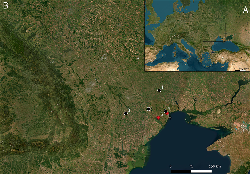
Location map of relevant sites. 1) Revova; 2) Crasnoe; 3) Cimişlia; 4) Kholodna Balka; 5) Mayaky; 6) Usatove-Velykyi Kuialnyk. Circles indicate kurgans; diamonds indicate enclosures (base map: ESRI, figure by Dmytro Kiosak).

Figure 1 Long description
The map displays the North Pontic Steppe region with key archaeological sites marked. These sites include Revova, Crasnoe, Cimilia, Kholodna Balka, Mayaky, and Usatove-Velykyi Kuialnyk. Circles on the map indicate kurgans, which are burial mounds, while diamonds represent enclosures. The map is based on data from ESRI and is created by Dmytro Kiosak.
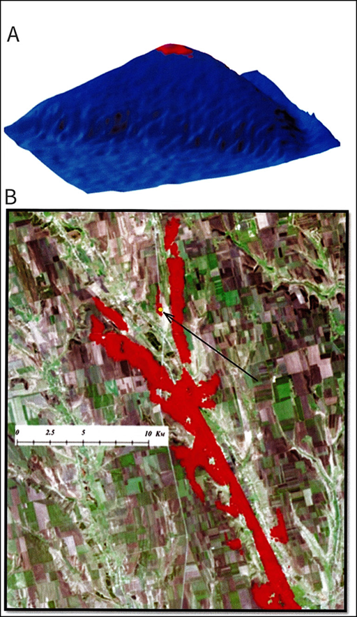
A) Kurgan 3 (red) in the modelled landscape (blue); B) viewshed (places that can be seen from the kurgan by a 1.7m-tall person) of Kurgan 3 (red) (figure by Simon Radchenko).

Figure 2 Long description
The image consists of two elements: a 3D model and a map. The 3D model shows a landscape with a kurgan highlighted in red. The map displays the viewshed of the kurgan, indicating the areas visible from the kurgan by a 1.7-meter-tall person, also highlighted in red. The 3D model and the map are separate but related, illustrating the visibility range from the kurgan.
Stratigraphy and dating
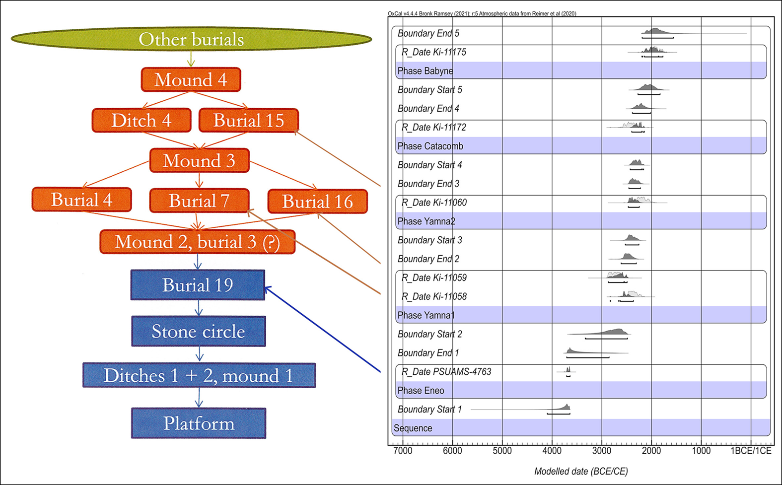
The stratigraphy of Kurgan 3 encompasses four overlapping mound layers, representing different Eneolithic–Early Bronze Age construction horizons. Radiocarbon dates establish a burial sequence spanning nearly two millennia (3711–1748 cal BCE; Ivanova et al. Reference Ivanova2005; Nikitin et al. Reference Nikitin2025) (Figure 3).
The Harris matrix and radiocarbon dates for Revova 3: Red) Yamna; blue) Eneolithic; green) later burial (figure by Dmytro Kiosak).

Figure 3 Long description
The line graph illustrates the Harris matrix and radiocarbon dates for Revova 3, highlighting the chronological sequence of various burial phases. The graph is divided into three distinct color-coded sections: red for Yamna, blue for Eneolithic, and green for later burials. The x-axis represents the modeled dates ranging from 7000 BCE to 1 BCE/CE, while the y-axis lists different phases and boundaries. Key phases include Babyne, Catacomb, Yamna 2, Yamna 1, and Eneolithic, each marked with specific radiocarbon dates. The graph shows the interaction and overlap of these phases, indicating the continuity of sacred spaces over time. All values are approximated.
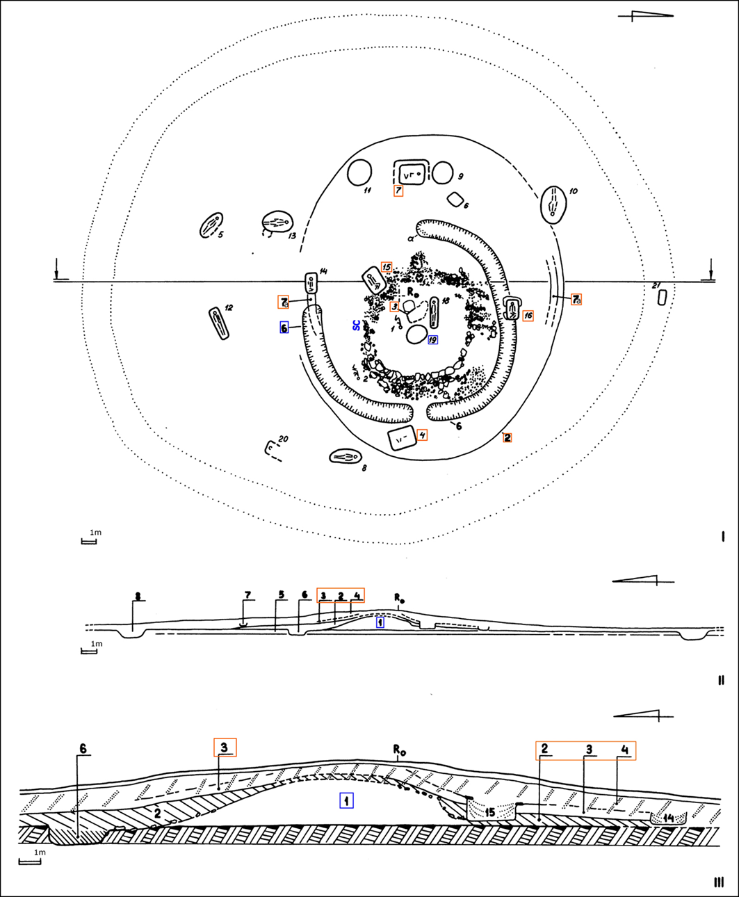
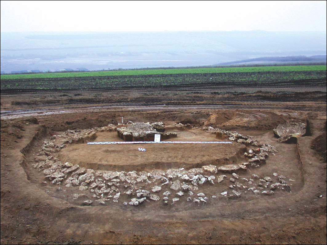
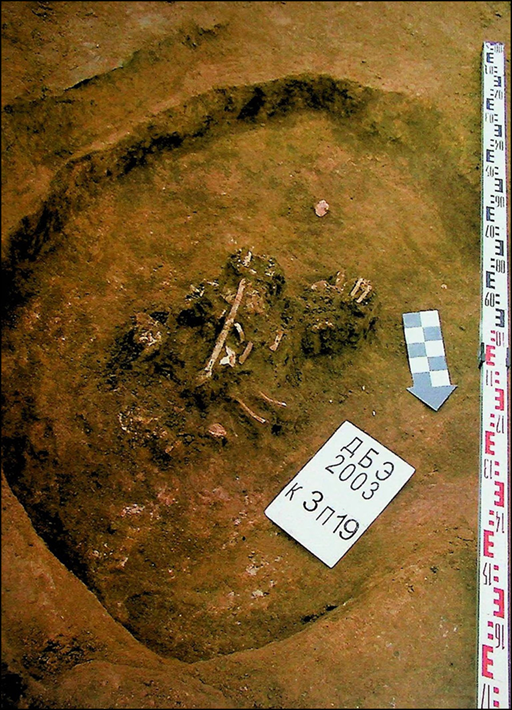
The Eneolithic ritual landscape at Revova 3 consisted of a platform from which topsoil was removed down to the underlying yellow loam. A mound (layer 1) was constructed on top of this platform using loam taken from a semi-circular ditch (Figure 4: 6) with a south-west-oriented causeway and two round pits. A stone arrangement with an elongated east–west axis encircled the mound (Figures 4 & 5). A pit was dug into the centre of the mound and disarticulated human remains were deposited c. 3711–3639 BCE (burial 19, 4905±20 BP, PSUAMS-4763; Nikitin et al. Reference Nikitin2025); positioning of the bones suggests they were deposited in an organic container. The pit may have remained open for some time before being filled in.
Plan (I) and profiles (II & III) of Revova Kurgan 3: 1–4) mound layers; 5) sterile clay; 6–8) ditches; a) fires; SC) stone construction. Blue boxes indicate Eneolithic features; orange boxes indicate Yamna features. (III) (figure by Svitlana Ivanova).

Figure 4 Long description
A cross-sectional diagram of Revova Kurgan 3, displaying the plan and profiles of the mound. The diagram includes labeled parts such as mound layers, sterile clay, ditches, fires, and stone construction. Blue boxes indicate Eneolithic features, while orange boxes indicate Yamna features. The plan view (I) shows the horizontal layout, and the profiles (II and III) provide vertical cross-sections. Key internal components include the mound layers, ditches, and specific cultural features marked by different colors.
The Eneolithic stone construction of Revova Kurgan 3 (figure by Svitlana Ivanova).

Figure 5 Long description
The Eneolithic stone construction of Revova Kurgan 3, an archaeological site in the north-western Pontic Steppe. The image shows a cross-sectional view of the kurgan, revealing layers of soil and stone. The outer layer consists of a circular arrangement of large stones, forming the base of the mound. Inside this stone circle, there is a central area with a smaller, raised platform made of smaller stones. Surrounding the central platform, the ground appears to be carefully leveled and compacted. The image captures the intricate design and construction techniques used by the Eneolithic inhabitants, highlighting their ritual and burial practices.
Burial 19 of Revova Kurgan 3 (figure by Svitlana Ivanova).

Figure 6 Long description
The image presents an aerial view of a burial site, showcasing skeletal remains partially covered by soil. A rectangular marker with the inscription 'ДБЭ 2003 к ЗП19' is placed near the remains. A blue and white checkered arrow points towards the skeletal structure. A vertical measuring scale is positioned on the right side of the image, providing a reference for the dimensions of the burial site.
A loam backfill subsequently covered the Eneolithic features (mound layer 2), derived from an outer shallow, circular ditch (Figure 4: 7a) that partially overlaps with the primary ditch in the southern part and is centred around burial 3. The centres of both mounds almost coincide. The burial is identified as Yamna based on stratigraphy and the construction of the funerary pit, which cut into the underlying loam of mound layer 1 without disturbing the adjacent burial 19. Two large stone slabs covered burial 3.
Three more burials, 16 (2885–2501 cal BCE, 4135±60 BP, Ki-11059; Ivanova et al. Reference Ivanova2005), 4 and 7 (2570–2204 cal BCE, 3910±60 BP, Ki-11058; Ivanova et al. Reference Ivanova2005) were interred at the northern, eastern and western edges of mound layer 2 (Figure 4) and were subsequently covered by chernozem mound layer 3, containing burial 15 (2456–2030 cal BCE, 3780±70 BP, Ki-11060; Ivanova et al. Reference Ivanova2005) (Figure 3). Taken together, these burials display characteristic Yamna features, with individuals laid in a contracted position on the back or side, pits with ledges and postholes along the walls, wooden covers, anthropomorphic stelae, mats, and the use of ochre. Mound layer 4 was added after the deposition of burial 15 and contained additional Bronze Age burials.
Palaeogenetic analysis
The genetic connection between Yamna and the Eneolithic populations of the North Pontic is well established. Whole genome analysis of burial 19 revealed a shared ancestry with the Usatove population of nearby Mayaky and Usatove sites (Penske et al. Reference Penske2023; Nikitin et al. Reference Nikitin2025). Approximately half of the Usatove genetic ancestry is shared with the Yamna gene pool originating in the Caucasus-Lower Volga (CLV) area. Individuals with CLV ancestry reached the North Pontic in the second half of the fifth millennium BCE. The Y-chromosome lineage of the individual from burial 19 traces back to the Near East highlands, while its mitochondrial DNA likely originated from the local steppe, a lineage also found in Yamna individuals in the north-west Pontic.
Interpretation
While the Eneolithic mound at Revova 3 contained a burial, the mound was not erected above the burial and may have been primarily a sanctuary. Evidence of fires in the associated ditches resembles ritual activities performed at causewayed enclosures, including some Eneolithic enclosures in the Pontic Steppe (Radchenko & Tuboltsev Reference Radchenko and Tuboltsev2019). These sites (shown in Figure 1) share a relative chronology and comparable shape, featuring ditches with causeways oriented south-west, megalithic elements and disarticulated remains.
Yamna interaction with earlier monuments is well documented; kurgans were erected on settlements, the dead were interred in the mounds of preceding communities, rock art instances were modified to fit their worldview (Videiko et al. Reference Videiko2015; Ahola Reference Ahola2020; Radchenko et al. Reference Radchenko2020) and Yamna nomads often destroyed or damaged Eneolithic anthropomorphic stelae, reusing them in their ritual practices (Vierzig Reference Vierzig2020: 131). This pattern of appropriation probably stemmed from the proselytism of a new ‘Steppe-originated religion’ propagated by steppe-derived peoples, such as those today referred to as the Yamna and Corded Ware groups (Ivanova Reference Ivanova2006; Ahola Reference Ahola2020). For mobile steppe groups, religion played a pivotal role both in fostering a sense of belonging and in exerting control over their lands (Ahola Reference Ahola2020; Preda-Bălănică et al. Reference Preda-Bălănică2020).
The landscape itself may have favoured reuse of the site; Kurgan 3, only 1.1m high, was positioned at a point where orographic lines converge, providing a line of sight over 25km down the Velykyi Kuialnyk River (Figure 2). Spatial correlation may suggest intentional reuse of visibly significant sites, even without viewing them as forebearers’ sacred places.
Yet, the central placement of the later burial 3 within the pre-existing Eneolithic structure—without disturbing earlier features—suggests the deliberate appropriation of an earlier ritual site, possibly to reaffirm the sense of continuing belonging in an ancestral landscape. The observed continuity of sacred spaces could indicate a degree of population and cultural continuity in the region, corroborated by genetic data (Nikitin et al. Reference Nikitin2025), from the Eneolithic to the Yamna. By reconstructing the patterns of use and reuse of sacred spaces in the North Pontic Steppe, we can gain a more nuanced understanding of the complex cultural and demographic shifts in this transformative geographic region.
Funding statement
D.K. benefited from the University of Bordeaux’s programme GPR ‘Human Past’. S.R. benefitted from the European Union’s Horizon Europe programme (MSCA 101153375).
Author contributions: using CRediT categories
Svitlana Ivanova: Data curation-Equal, Investigation-Equal, Methodology-Equal, Supervision-Equal. Alexey G. Nikitin: Formal analysis-Equal, Investigation-Equal, Methodology-Equal. Simon Radchenko: Formal analysis-Supporting. Dmytro Kiosak: Conceptualization-Equal, Data curation-Equal, Formal analysis-Equal, Funding acquisition-Equal, Project administration-Equal.

 Open access