Introduction
During the sixth German Antarctic North Victoria Land Expedition (GANOVEX VI, 1990–91), a glacio-geological reconnaissance was carried out in the area between David and Mawson Glaciers (Reference Verbers, Wateren, vander, Yoshida, Kaminuma and ShiraishiVerbers and van der Wateren, 1992). Based on this reconnaissance, two principal hypotheses were developed:
-
1. The ice sheet retreated substantially during theearly Pliocene (~5-3 Ma), resulting in a marinetransgression. This period was followed by an ice-sheet re-advance.
This hypothesis is based on the presence of marine diatom-bearing till (Sirius Group) on the summit plateaux of the nunataks (Reference Verbers, Wateren, vander, Yoshida, Kaminuma and ShiraishiVerbers and van der Wateren, 1992). This is in accord with glacial histories described in the central Transantarctic Mountains (Reference Webb and HarwoodWebb and Harwood, 1991; Reference Barrett, Adams, McIntosh, Swisher and WilsonBarrett and others, 1992).
-
2. Multiple glacial valley erosion is a consequence ofepisodic late Pliocene/Pleistocene mountain uplift. The second hypothesis is based on the morphologyof the nunataks and on the erratic dispersal pattern.Results of exposure dating in northern VictoriaLand support this statement (Reference Wateren, vanders, Verber, Yoshida, Kaminuma and Shiraishivan der Wateren and Verbers, 1992).
This paper reports on new observations of the DavidGlacier region taken during GANOVEX VII, 1992–93. It advances a model of glacial retreats and advances together with episodic mountain uplift to account for the observed subglacial topography.
Ice-thickness measurements
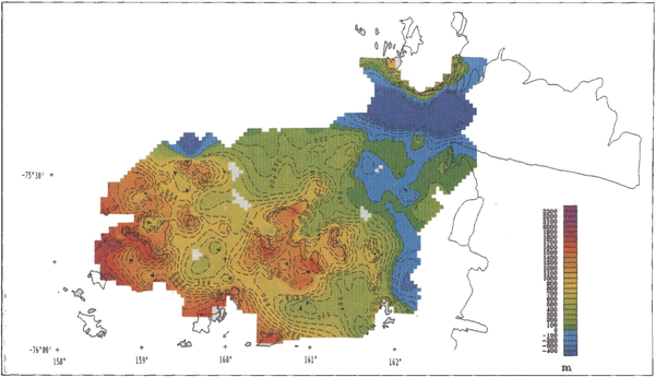
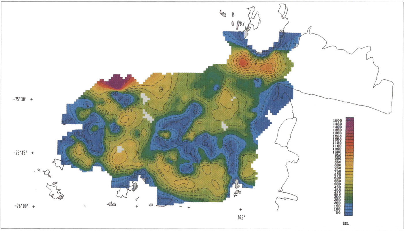
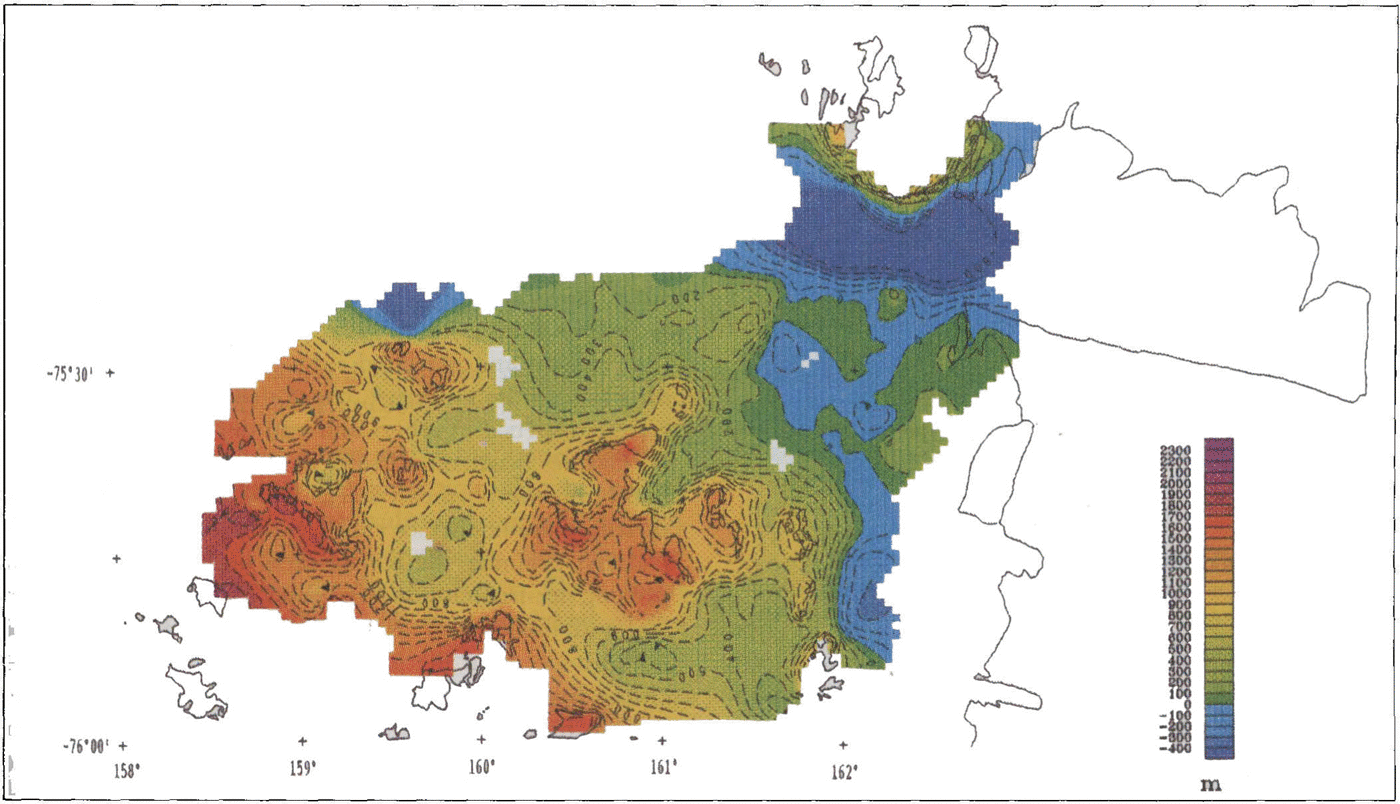
The ice thickness of the area between David and Mawson Glaciers was determined using an airborne radio-echo-sounding system developed by the B.G.R. The antennas of the system were mounted on a bird which was suspended about 20 m beneath the helicopter, and 10–20 m above the ice surface. The reflections of the radar pulses in the band of 20–80 MHz were recorded on an analog system and later digitized for further computer analysis and to produce computer-generated contour maps. A Magellan GPS unit was used for positioning the reflection points. This is a C/A code receiver with an accuracy of about 100 m in the horizontal for a single measurement. The accuracy was improved by continuous measurements of the GPS unit during each flight (I position s-1 ) and by tracking many more than the minimum of four satellites. Because of the small scatter of GPS data along each flight path, we are confident that the accuracy is suitable for our purpose and could be estimated as an error of no more than 50 m. All calculations, i.e. geographic and elevation positioning as well as depth of reflections, were done during post-processing at the B.G.R. A wave velocity of 168 ms-1 through ice was assumed for all data. Along profiles of about 1500 km length and on an irregular grid (approx. 8000 km2 ), about 1000 reflections were recorded and included in the final interpretation. The position of each reflection point was recalculated using the continuously measured GPS data and the time of radar reflection which was stored for each measurement on a personal computer. The positions of data points were plotted on a map and the edges of all outcrops in the area were set with a zero ice thickness, based on the 1:250 000 USGS topographic maps “Mount Joyce” and “Relief Inlet” (Fig. 1). These data were used to generate an isopach map of the ice using the GEOSOFT software package (and the interpolation algorithm of kriging) (Fig. 2). To derive the subglacialtopography, the surface topography from the USGS maps was digitized and gridded using the same scheme. The ice-thickness grid was subtracted to obtain bottom elevations (Fig. 3).
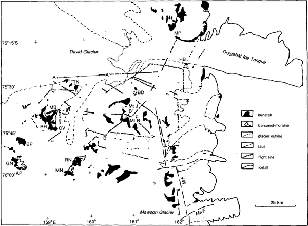
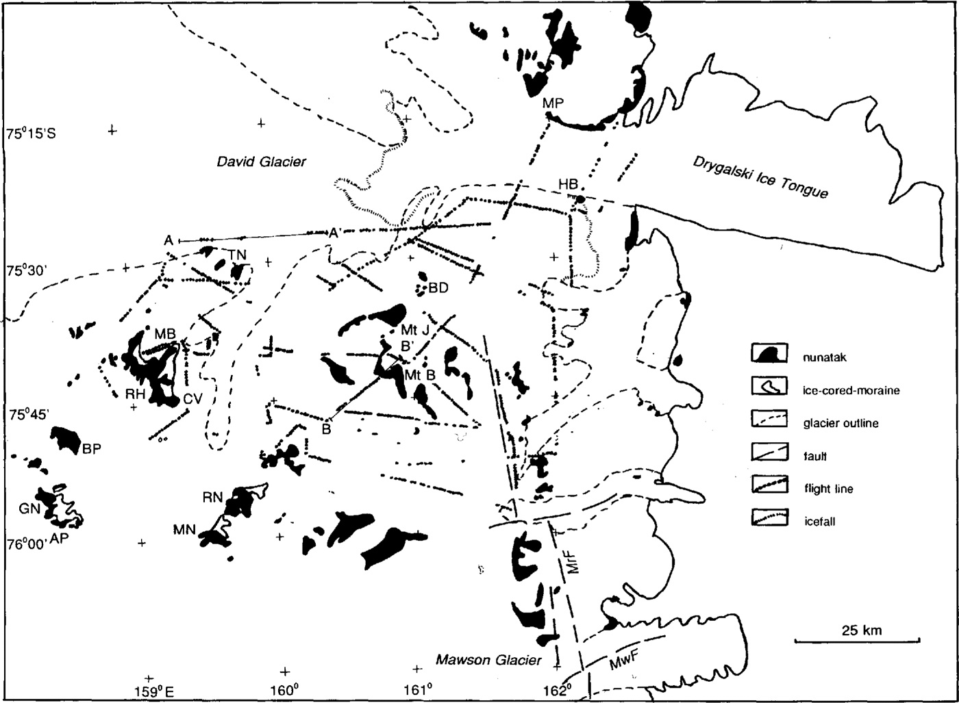
Research area.MwF, Mawson Fault; MrF, Murray Fault; AP, Ambalada Peak; BD, Burrage Dome; BP, Brimstone Peak; CV, Cirque Valley; GN, Griffin Nunatak; HB, Hughes Bluff; MB, Morris Basin; MN, McLea Nunatak; MtB, Mount Billing; Mt⁈, Mount ⁈oyce; MP, Mount Priestley; RH, Ricker Hills; RN, Richard Nunatak; TN, Trio Nunatak. (Map is based on Reference CarmignaniCarmignani and others (1988) and Reference Skinner and RickerSkinner and Ricker (1968))Nunataks are in black; flight lines are dotted.
Ice-thickness map
Subglacial topography map
Interpretation
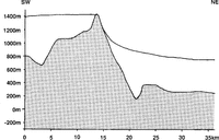
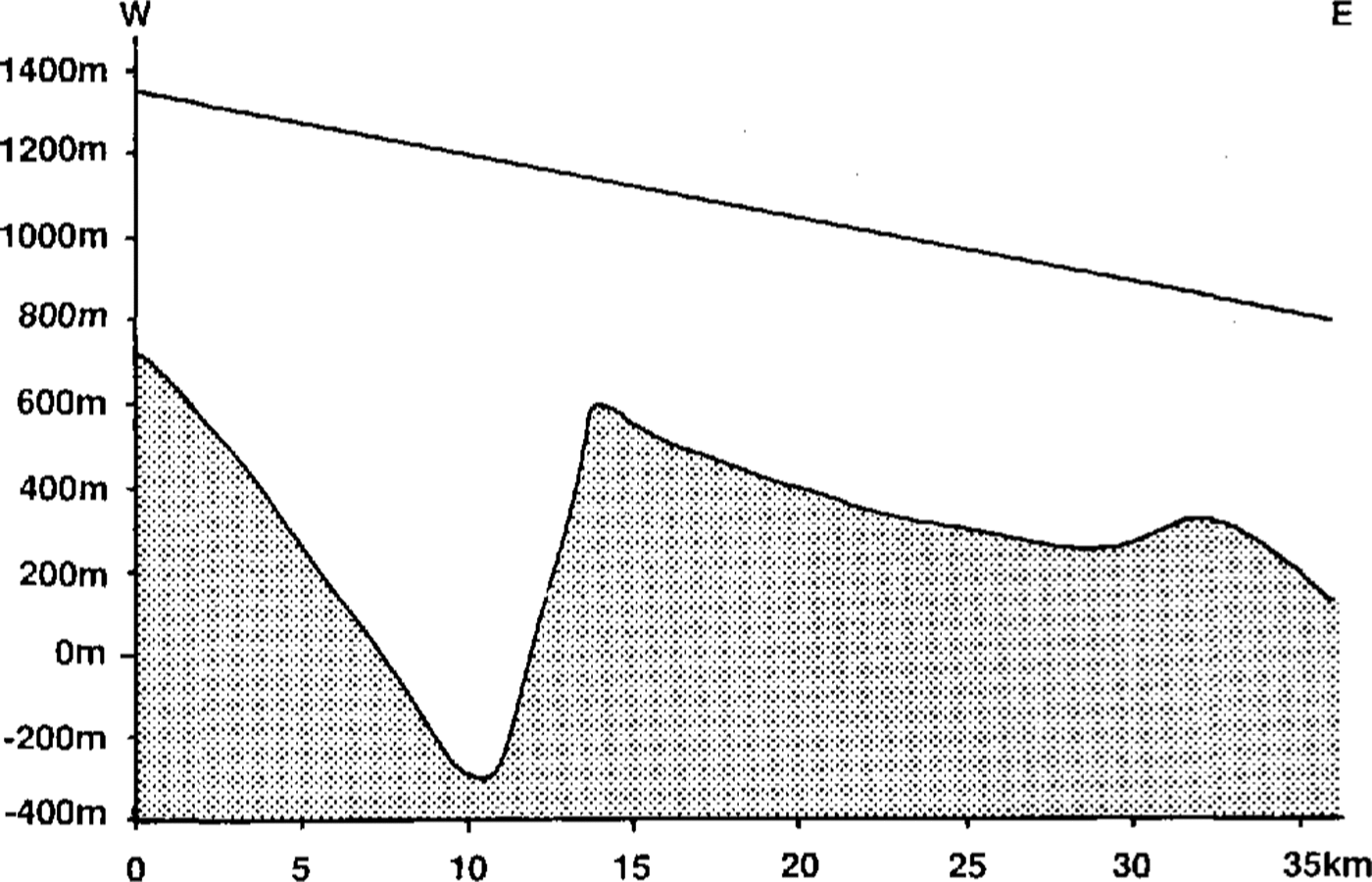
The northern part of the map shows a part of the subglacial trench of David Glacier (Fig. 3). David Glacier is an outlet glacier that drains an area of 224000 km2 east of Dome Circe in central Victoria Land, Antarctica (Reference ChinnChinn, 1988). The greatest measured ice thickness of David Glacier is 2530 m, just inland of the main icefall (Reference Steed, Drewry and CraddockSteed and Drewry, 1982). At this point, the glacier bed reaches 1630 m below sea level. Just north of Trio Nunatak, a depression followed by a sub glacial ridge was recognized in our measurements (Fig. 4). It coincides with the icefall north of Trio Nunatak. At this location, the ice thickness is 1500 m, and the depression reaches 300 m below sea level. This depression might extend to the northeast to meet the deep depression measured by Reference Steed, Drewry and CraddockSteed and Drewry (1982). This southwest-northeast running depression might follow a fault, which would fit in the fault system proposed below. In our measurements, David Glacier reaches its greatest depth of-1000 m m.s.l. at the narrowest point, between Hughes Bluff and Mount Priestley (Fig. 1)
West-east cross-section of David Glacier, north of Trio Nunatak; for location see profile A-A' in Figure 1. Bedrock, dotted;ice, white.
The valley of David Glacier is deep in comparison with the valleys to the south. The latter divide the area into clusters of nunataks in a rectangular pattern. This rectangular pattern might reflect a fault system in the Bed rock. The presence of faults in the coastal area has already been suggested by Reference Gunn and WarrenGunn and Warren (1962) and Reference Skinner and RickerSkinner and Ricker (1968). The latter suggested that extensive block faulting took place, based on displacement of topographic features and reference surfaces (Fig. 1). Reference Stackebrandt, Watercn, van, Verbers and TessensohnStackebrandt (1994) proposed a late Cenozoic rectangular fault and fracture pattern with similarorientations for the area north of David Glacier. Reference Gunn and WarrenGunn and Warren (1962) suggested that David Glacier occupies a transverse fault. Fault patterns in relation to ice-filled valleys have also been described from Marie Byrd Land by Reference LeMasurier, Rex and CraddockLe Masurier and Rex (1982).
Closed sub glacial depressions occur in the central parts of the glacial valleys. They are about 200 m deeper the mean depth of the valleys. The depressions may be the result of glacial erosion along faults, as zones of weakness caused by the faulting enhances the depth of glacial erosion. Reference Orombelli, Baroni and DentonOrombelli and others (1991) suggested glacial valley formation by headward erosion. At this stage, we are unable to test which model applies.
Subglacial depressions also occur associated with the nunatak clusters. The depressions are bounded by nunatak walls but open to one side. The open side is separated from the main valley by a threshold, which can be 200 m high (Fig. 5). These depressions are taken to be subglacial cirques
Southwest-northeast cross-section of Mount Billing; for location see profile B-B' in Figure l.

Exposed topography
The area consists of a number of nunatak clusters surrounded by vast areas of ice. The bedrock geology is relatively simple. A Precambrian/Palacozoic meta-morphic/granitic basement is sub-horizontally and un-conformably overlain by Jurassic Ferrar Group basic volcanics with rafts of Palaeozoic and Mesozoic Beacon Supergroup sediments (Reference Skinner and RickerSkinner and Ricker, 1968; Reference WörnerWörner,1992).
The nunataks show four morphological units representing different phases of glaciation; summit plateaux, terraces, cirques and ice-cored moraines. At present, the nunataks expose shallow undulating summit plateaux. They rise in altitude from 1000 m near the coast to 2300 m in the westernmost, inland part of the area. The difference in elevation between the plateaux and the ice surface ranges between 400 and 800 m on the northeast side of the nunataks, while on the southwest sides this is between 50 and 500 m. Terraccs and glacially rounded ridges are situated between 150 and 400 m above the ice surface. They are assumed to have formed by glacial erosion and represent remnants of former glacial valley floors. Large cirques with a diameter up to 8 km are present at a number of nunataks. Ice-cored moraines are present on the north to northeast sides of all nunataks, and range between 0 and 50 m above the present ice surface. Based on their morphology, they consist of lateral moraines, shear moraines or dead-ice topography moraines. They might be Holocene to late Wisconsin in age (Reference Orombelli, Baroni and DentonOrombelli and others, 1991
Basement and Beacon Super group derived erratics arc absent on the summit plateaux. We suggest that the plateaux were formed before basement or Beacon Super group bedrock was exhumed and propose that the present-day plateaux are dissected remnants of a (glacial) erosion surface. The frequency of basement and Beacon Supergrouperratics increases towards landforms of lower elevation and towards the coast
Sirius Group till in which reworked Pliocene marine diatoms are present is found on the summit plateaux only, while it is absent on the terraces. The diatom Thalassiosiravulnifica indicates a mid-Pliocene age, while Thalassiosiralentiginosa is early Pliocene to recent in age (personal communication from D. M. Harwood, 1993)
The restricted occurrence of Sirius Group till on the plateaux suggests that glacial valleys were formed after deposition of the Sirius Group till. This valley erosion accounts for the absence of this type of till on the present-day terraces. The restricted occurrence of Sirius Group till also makes wind as the transport and deposition medium for these diatoms (Reference SugdenSugden, 1992) doubtful.
Former ice-flow directions can be detected on each morphological unit. On the summit plateaux, striations are absent, presumably because of weathering, but streamlined bedrock features and very shallow valleys indicate a former ice movement towards the northeast.
Terraces and glaciated ridges indicate a former flow direction to the northeast, concluded from striations and erratic dispersal (Reference Verbers, Wateren, vander, Yoshida, Kaminuma and ShiraishiVerbers and van der Wateren, 1992).
Cirques occur on all sides of the nunatak clusters but mostly on the northeast sides. This indicates that during their formation local ice caps were present on the nunatak clusters, draining the ice in each possible direction. At present, ice-free cirques are found at elevations between 800 and 1600 m a.s.l. Some of the cirque floors are even 100 m lower than the present regional ice surface, as the cirque lips prevent the ice from flowing into the cirque. During the Last Glacial Maximum (LGM) the ice sheet partly intruded into the empty cirques. Since then the ice has retreated, leaving series of ice-cored end moraines behind. The ice surface has lowered about 100 m, exhuming fresh striations on the cirque lips.At presentthe ice flows in a northeast direction, funneled by the southwest-northeast running valleys, or flowing over topographic steps which are present between the nunataks
Discussion
Reference Tessensohn, Wateren, vander, Verbers and TessensohnTessensohn (1994) suggested that the Transantarctic Mountains consist of several fault blocks, each with a different history. We suggest that each block also has its own glacial history that is linked to the uplift of the block Reference Wateren F.M, Verbers and TessensohnVan der Wateren and others, 1994; van der Wateren and others, in press). We propose a regional glacial history model that is consistent with the observations. The model is separated into “ice-sheet retreat phases” (1,3 and 5) and “ice-sheet advance phases” (2 and 4). There are two age constraints: the present day and the presence of mid-Pliocene diatoms on the summit plateaux.
Reference Barrett, Hambrey, Robinson, Thomson, Crame and ThomsonBarrett and others (1991) and Reference Hambrey, Larsen and EhrmannHambrey and others ;(1989) observed that glaciation of Antarctica started in early Oligocene (≥36 Ma) times. We accept this and assume that an icc sheet occupied the area prior to the Pliocene.
Model
-
1. During the earliest Pliocene (>5 Ma), the area between David and Mawson Glaciers comprised anundulating (glacial) erosion surface or peneplain. As a result of a major deglaciation of Antarctica, marine transgression occurred, via the DavidGlacier valley and other inlets, into basins west ofthe Transantarctic Mountains (Reference Webb, Harwood, McKelvey, Mercer and StottWebb and others,1984). The Wilkes sub glacial basin forms the hinterland of David Glacier, which at present hasa bedrock elevation as deep as -1000 m. If there bound to isostasy is taken into account, it reaches a maximum depth of about 0 mm.s.l. (Reference DrewryDrewry,1983). This presents a problem because marinetransgression would be hardly possible. Perhapsthere has been some minor tectonic uplift of centralAntarctica since Pliocene times, or there may be ashortcoming with the conventional models forrebound toward isostasy
-
2. In the late Pliocene, the East Antarctic ice sheetadvanced, flowing towards the northeast, depositing a layer of Sirius Group till, containing recycledmid-Pliocene marine diatoms (personal communication from D. M. Harwood, 1993).
-
2a Glacial dissection of the undulating peneplain took place. We suggest that formation of broad glacial valleys occurred along Emit lines and was induced by mountain uplift. Large amounts of debris were transported towards the northeast. Only small patches of Sirius Group till were preserved on the plateaux
-
3 The icc sheet partly retreated, exposing a landscape of nunatak clusters dissected by wide valleys.
-
3a A period of local cirque glaciation occurred, nunatak clusters were partly “eaten away” by these glaciers, producing the nunataks as they are today.
-
4 The ice sheet advanced again with an average flowdirection to the northeast but generally followingthe glacial valleys
-
4a Another phase of uplift accompanied by glacier erosion caused over deepening of the existing valleys. Presumably, uplift fractured rock and/or increased gradients that drive glacier motion and so made sub glacial erosion more effective. The remnants of the shallow valleys formed during phase 3 are the present-day terraces
-
5 At present, the ice continues to drain to the northeast but, probably since the Last Glacial Maximum, the ice has retreated about 100 m inelevation
Conclusions
The glacial history model as proposed in this paper is based on regional data and is therefore restricted. It shows large ice-volume fluctuations and is to a large extent influenced by recent mountain uplift. The age constraints are limited, although the presence of mid-Pliocene marine diatoms in the summit-plateaux till gives a maximum age for the morphology of the area.
Acknowledgements
We thank the Bundesanstaltfur Geowissenschaften und Rohstoffe (B.G.R., Hannover) for the invitation to participate in and the very good logistic support during GAKOVEX VII. We specially thank J. Kothe, B. Staite and W. Bremmers. The research of the first author (A.L.L.M.V.) was supported by a European Community sectoral grant, while her travel expenses were supported by The Netherlands Marine Research Foundation (S.O.Z.) of the Netherlands Organisation for Scientific Research (N.W.O.).