


Extensive terraced and irrigated agriculture was introduced into the Chicha Soras valley during Middle Horizon (MH) epoch 2 (about AD 680–900; Meddens et al. Reference Meddens, Venegas, Branch, Fehren-Schmitz, Meddens and Pomacanchari2025:46n1)Footnote 1 and focused on the southern part of the valley (Figure 1a). This arable sector was linked to a camelid herding zone on the altiplano to the southwest, around the Ñaupallacta settlement complex, and near to the obsidian sources of Lisahuacho and Potreropampa (Burger et al. Reference Burger, Rios and Glascock2006; Meddens et al. Reference Meddens, Venegas, Branch, Fehren-Schmitz, Meddens and Pomacanchari2025). The research presented here aims to demonstrate that the distribution of tombs in caves and rock art from the MH onward was related to the water distribution systems in the area. As noted by Kellett, burial monuments were “places with agency and power, which helped demarcate an active cultural landscape” (Kellett Reference Kellett2022:373). We aim to test the hypothesis that local lineages controlled these systems and the way this can be recognized across the landscape and elsewhere into the colonial period.
(a) Middle Horizon 2 site and tomb locations and agricultural terracing; (b) Late Intermediate period site and tomb locations and agricultural terracing.

The Chicha Soras valley will be seen to conform to a model as outlined by Saxe in his hypothesis #8, asserting a corporate group’s control of, and rights over, resources by means of lineal descent and ties to the ancestors in the formal disposal areas for exclusive disposal of the dead (Saxe Reference Saxe1970:119–121), and the communities’ cognitive processes, as revised by Goldstein (Reference Goldstein, Chapman, Kinnes and Randsborg1981:53–69).
The research covers an area from 3 km northwest of Soras, on the west bank of the Chicha Soras River and 1 km northwest of Pomacocha on the east bank defining the northern limit, to 3 km southeast of Ayapampa on the east bank and 1 km southeast of the village of Chicha on the west bank (Figure 1a). The altiplano to the east and west of the main river (at elevations above 3,600 m asl) was explored to a maximum distance of 15 km while the Yanamayo tributary is included over its full length.
The fieldwork data were collected between 1978 and 1982 with investigations completed as part of the principal author’s PhD research, with further work between 1999 and 2006 under the auspices of the Cusichaca Trust (nongovernmental organization) and in 2018 as part of the CROPP project (led by the University of Reading, UK). Kendall’s typology was used in the mapping of the agricultural terracing found across the study area (Kendall and Rodríguez Reference Kendall and Rodríguez2009). This defines four terrace types providing their technological characteristics such as are materially observable (Kendall and Rodríguez Reference Kendall and Rodríguez2009): type 1, terracing with approximately horizontal profiles with inclined retaining walls, generally irrigated; type 2, terracing with approximately horizontal profiles with vertical retaining walls, both with and without irrigation; type 3, terracing with inclined platforms (with a simple retaining wall; e.g., fieldstone and single stone width), sometimes with and usually without irrigation; and type 4, terracing with sloping terrain surfaces without a platform, lacking walls and irrigation, usually the result of foot plough action, agricultural practices and natural slope erosion processes (Kendall and Rodríguez Reference Kendall and Rodríguez2009).
For the dating of the agricultural systems in the Chicha Soras valley complementary methods were used. Irrigation systems are found embedded in agricultural terracing and are considered largely contemporary with the initial construction of the terracing. Individual terraces were dated, where these were excavated, by the associated datable ceramic material in the fills of their construction cuts and surfaces. Eleven terraces were excavated across seven locations on both sides of the river. Micro charcoal from buried soils representing former terrace and construction surfaces for some of these terraces were 14C dated. Ceramic dating concurred with the 14C dating in every instance (Branch et al. Reference Branch, Kemp, Silva, Meddens, Williams, Kendall and Pomacanchari2007; Kemp et al. Reference Kemp, Branch, Silva, Meddens, Williams, Kendall and Cirilo Vivanco2006).
To date groups of agricultural infrastructure forming part of individual delimited systems—for example, terracing of the same type with defined limits and frequently associated with circumscribed irrigation systems—the relationships between agricultural infrastructure and dated settlement sites as well as those between agricultural terracing and water management structures were used. The relationships observed include terracing walls bonded or abutting habitational structures, as well as bonding of structural features into terrace walls (Figure 2a). Irrigation infrastructure cutting through habitational structures and irrigation infrastructure integrated with agricultural terracing were noted. Insertion of reservoirs and modifications to previously existing irrigation systems were recorded (Figure 2c). Later structures found superimposed on earlier infrastructure were also found (Figure 2b).
(a) Corbels supporting the roof of a Middle Horizon 2 structure bonded into a terrace wall; (b) Late Horizon circular structure built over Late Intermediate period terrace wall; (c) Late Horizon reservoirs built over and into LIP terracing.

The datasets used included for the 1980s targeted surface investigation based on information provided by local informants as well as systematic fieldwalking across a 10% stratified random sample of the research area. Representative sections of sites with surface architecture were mapped using a Brunton compass and 30 m tapes. Excavations were completed on four settlement sites (Meddens Reference Meddens1985). The Cusichaca Trust collected initial site data in participatory workshops involving local authorities and residents. Here information was collected regarding the existence of archaeological remains. This was followed by targeted fieldwalking using a handheld GPS for locational data recording (accuracy range ±8 m). Further sites were found in a systematic fieldwalking program. The recording of agricultural infrastructure consisted of the delimitation of areas with terracing using a Tracking Log methodology with a handheld GPS. This consisted of walking around the perimeter of terrace units, which were recorded in the GPS as digital paths that identified the physical geographical delimitation of land parcels, conforming to defined units of terracing. The routes of irrigation channels were recorded using GPS Tracking Logs, comprising the walking of the trajectory of a canal from its beginning to its end. The 2018 fieldwork included drone surveys of 16 sites across the area. Of these 14 were settlement sites, one a wetland area with irrigation infrastructure and rock art, and one a funerary complex comprising chullpas. These sites were further subjected to walkover ground proofing. A digitized cartographic system and database served to compare and analyze the data across the research area. This was created using appropriate software packages.
The methodology followed in the dating of the agricultural infrastructure confirmed that Kendall’s published dating of her terrace typology and associated irrigation is inadequate across the study area considered here (Kendall and Rodríguez Reference Kendall and Rodríguez2009). Kendall’s type 1 terrace as being of Late Horizon (LH) date here cannot be retained. In all instances in which excavation results were obtained from type 1, terracing, dates for the initial phase of construction were MH (Branch et al. Reference Branch, Kemp, Silva, Meddens, Williams, Kendall and Pomacanchari2007; Keeley and Meddens Reference Keeley and Meddens1993; Kemp et al. Reference Kemp, Branch, Silva, Meddens, Williams, Kendall and Cirilo Vivanco2006). In part the disagreement about dating rests in the fact that Kendall states that subtype 1(d) is a close approximation of types 2(a) and 2(b), which date to the MH (Kendall and Rodríguez Reference Kendall and Rodríguez2009:86); these subtypes are largely indistinguishable.
The Agricultural Infrastructure of the Chicha Soras Valley
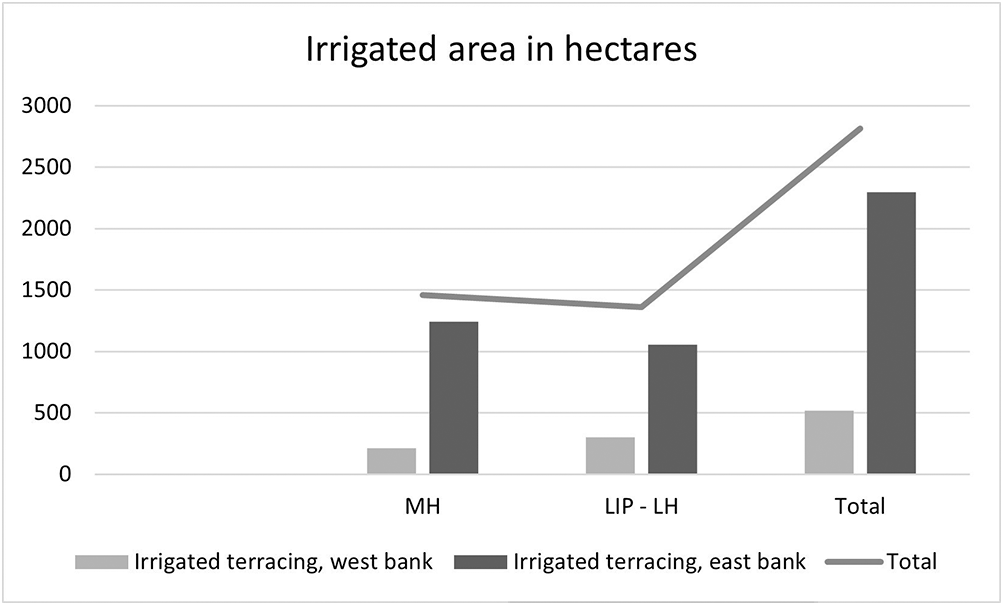
The initial MH construction of the upper Chicha Soras valley field systems comprised 2,979 ha of terracing (Figures 1a and 3) of which 1,456 ha were irrigated (Figure 4). The terracing comprises types 1 to 3 following Kendall’s typology, predominantly types 1 and 2 (e.g. 65%). We have mostly not been able to distinguish agricultural infrastructure constructed during the Late Intermediate period (LIP) from that built during the LH. This terracing is therefore subsumed in a single LIP/LH phase. Both agricultural infrastructure and embedded irrigation and occupation sites expanded northward (downstream) during this phase (Figure 1b). This increased the terraced terrain by 1,243 ha or by some 29.4% to now total 4,221 ha (Figures 1b and 3), of which an additional area of 1,359 ha were irrigated, now totaling 2,815 ha (Figure 4). The increase in irrigated field systems over the LIP/LH phase was 48.3%.
Areas of agricultural terracing in the Chicha Soras research area, for the MH, the Late Intermediate period and Late Horizon, and the total area with terracing, in hectares.

Areas of irrigated agricultural terracing in the Chicha Soras research area, for the Middle Horizon, the Late Intermediate period and Late Horizon, and the total area with irrigated terracing.

The surge in irrigated arable field systems is associated with significant population increase during the LIP. The number of settlements grew from seven to 13 with the site size increasing, from 6/7 ha to a maximum of 27 ha. The number of communal tombs in caves and rock shelters increases from three to 12. This period witnesses a significant reduction in precipitation (Handley et al. Reference Handley, Branch, Meddens, Simmonds and Iriarte2024; Meddens et al. Reference Meddens, Venegas, Branch, Fehren-Schmitz, Meddens and Pomacanchari2025), which may explain the nearly doubling of irrigated terracing at this time.
Middle Horizon and Late Intermediate Period Social Control and Water Management
The Landscape and Its Huacas and Wamanis
The Chicha Soras valley and the altiplano fringing it abounds with animated sacralized and socialized elements. These include among the principal tutelary and chthonic forms mountain deities, or wamanis, such as the summit of Ccarahuarazo and the rounded pink peak of Apu Pancola. Such socialized mountain deities (Bastien Reference Bastien1978) stood in a relationship with and were linked to caves that were perceived as operating as gateways into the worlds below and places of origin, such as for the Incas the Pacaritambo cave from which their mythical ancestors emerged. Such summits are accepted as among the principal sources of water from springs on their flanks, thawing snow and ice, and rain attracted to their crests (Gil García and Fernández Juárez Reference García, Francisco and Fernández Juárez2008:106–107). The mountain deities, as all huacas and mallquis, can be both benevolent and malevolent and require regular feeding in their reciprocal relationship with people (Gil García and Fernández Juárez Reference García, Francisco and Fernández Juárez2008; Ramirez Reference Ramirez2005). For many Andean communities designated mountains were considered as deities and places of origin for their mythical founding ancestors (Acuto and Leibowicz Reference Acuto and Leibowicz2020:321, 326), while for the mallquis both their places of origin and places of burial were viewed as pacarinas (Doyle Reference Doyle1988:125, 240–243). Smaller animated elements across the local terrain include features as springs, tombs, and stones, some with rock art as well as standing stones, or huancas, the latter representing proprietary markers, as well as groups of remarkable eroded conical features that complete the groups of resident esoteric sacred features across this topography.
The Middle Horizon Communal Tomb Distribution
In the Chicha Soras valley, a series of communal tombs are found at the upper limit of the valley on either valley margin. These are situated at the upper edge of the basin, where agricultural terracing extends to the base of the cliffs on the boundary between the valley and the altiplano (Figures 1a, and 5). These communal tombs exist in caves and rock shelters and are proximal to points of access of water flowing into the valley from the surrounding altiplano. These comprise natural transition points in the hydrology such as waterfalls, in conjunction with irrigation canals.
The Charrangochayoc tomb at the base of the cliff above the uppermost agricultural terracing.

These communal tombs include interior walling and build elements. They have all been looted, but the remaining cultural evidence at these locations confirms that they originally held the mummified bodies of multiple individuals, most having originally been in flexed, seated positions, accompanied by grave goods. The artifactual material dates from the MH into the later precontact periods.
Notable examples of these tombs comprise Cañal (Figures 1a and 6), in close proximity to the Infierilloc falls and irrigation intake, feeding the irrigation system around Ayapampa (Figure 6); Marcalo, close to a canal intake and stream feeding the irrigation system around the site of Laymi (Figure 1a); and Charrangochayoc, near a canal, supplying 20 ha of terracing around the site of Yako (Figures 1a and 5). This tomb is by far the largest with a multilevel structure with window-like access points and white plastered walls originally containing the remains of some 200 individuals or more (Isbell Reference Isbell1997; Meddens Reference Meddens, Isbell and McEwan1991).
The Cañal communal tomb with its associated irrigation system and terracing.

These settings were all highly visible in the landscape, with the link between the ancestral dead or mallqui and water being anchored in Andean concepts that consider water as ensuring agricultural productivity and originating from the process of desiccation of ancestral corpses (Allen Reference Allen1988, Reference Allen, Shimada and Fitzsimmons2015; Gose Reference Gose1993; Herrera Wassilowsky Reference Wassilowsky and Alexander2024:65; Salomon Reference Salomon, Shimada and Fitzsimmons2015). Such traditions continue to be referenced in contemporary ritual engagements largely concerned with community canal cleaning episodes (Allen Reference Allen1988, Reference Allen, Shimada and Fitzsimmons2015).
A related practice was reported locally in 1979, when, on delayed arrival of the rainy season, human remains were gathered from tomb contexts and burned to encourage the “gentiles” to bring rain. The heat of the combustion could be seen as propelling moisture from these remains. In the journey of the dead from the world of the living to Ukhu Pacha, it is heat that is considered driving the moisture from the ancestral bodies (Allen Reference Allen1988) to return to feed the arable crops. The handling of such bones is believed dangerous, bringing with it the risk of an affliction called mal-aire.
A similar tradition called awilu turkuy is noted for the community of Acopalca in Ancash, where at times when rains fail, or are excessive, community elders or ritual specialists are delegated to retrieve human remains from two late precontact tombs present on community lands. The remains must be handled with circumspection to avoid exposure to a condition termed malcampo. A skull or bones will be suspended from a pole placed in a selected arable field. The rituals aim to reduce heat or rain depending on the conditions to be mitigated. Similar ceremonies are reported for Chacas where the human remains on poles are mobilized around glacial lakes (Orsini and Benozzi Reference Orsini and Benozzi2013:114).
The location of the ancestral tomb at the point of origin of water feeding designated irrigation systems visually would have confirmed the ayllu’s or lineage’s claim to rights to specific water sources and the irrigation system and terracing over which this water was distributed (Figures 5 and 6; Herrera Wassilowsky Reference Wassilowsky and Alexander2024:30). It was common for necropolises to be situated in areas with a great deal of water, as ancestors were considered its guardians and providers (Sánchez Garrafa Reference Sánchez Garrafa2015:75).
The ayllu served to control, manage, and defend productive resources (Weismantel Reference Weismantel and Creed2006:95), while traditional Andean concepts of ownership of canals and rights to land and water rest in the founding ancestor of an ayllu. It is this founding ancestor who will have first distributed water to the land and laid claim to the arable and water resource and hence obtained by the ayllu (Ambrosino Reference Ambrosino2018; Herrera Wassilowsky Reference Wassilowsky and Alexander2024; Sherbondy Reference Sherbondy1982:22). In much of the mythology founding ancestors will have been directly responsible for the initial locating of water sources or construction of principal canals. It is the annual maintenance of, and ritual events dedicated to, the water-related infrastructure that signify the continued rights of the ayllu and entitlement of its use by its individual members (Sherbondy Reference Sherbondy1982:23).
Kurin (Reference Kurin2016) has suggested that moiety and ayllu divisions in the Chanka population of Apurimac were in part differentiated by variations in cranial shape modifications, found grouped in populations from cave and rock shelter tombs. The artifactual and settlement data have proven to be of very limited use in the identification of ayllus elsewhere in the former Chanka territory (Kellet Reference Kellett2022).
The Cañal, Charrangochayoc, and Marcalo tomb assemblages confirm these funerary sites were used from MH epoch 2 onward, likely until the early colonial period when the extirpation activities of the colonial church stopped the practice. These sites were in part selected for funerary use as their dry conditions resulted in natural mummification of the corpses placed within them. Their projected link to the respective lineages or ayllus with their claim to the corresponding lands and irrigation systems confirms that for this area, from the MH epoch 2 onward, the ayllu social construct was operative. As the first large-scale occupation of the Chicha Soras valley and its hinterland dates to this period (Meddens et al. Reference Meddens, Venegas, Branch, Fehren-Schmitz, Meddens and Pomacanchari2025), it is assumed that the ayllu form of social organization arrived in the area fully formed. The antiquity of the ayllu has been subject to much discussion (Ambrosino Reference Ambrosino2018; Isbell Reference Isbell1997; Jennings and Berquist Reference Jennings and Berquist2022). While the ayllu is considered to have been associated with the MH Wari polity, it has been suggested that it arrived at a stable form in the seventh century (Jennings and Berquist Reference Jennings and Berquist2022:357). Isbell attributed the cave and rock shelter-based tomb type to his Open Sepulcher category (Reference Isbell1997:183), which he couples with ayllu social structure (Isbell Reference Isbell1997). Continuity of this tradition in the Andes is widespread; for example, for the colonial period, records of seventeenth-century extirpation trials report a recurring link between caves accommodating communal tombs and defined ayllus in the Cajatambo region (Duvoils Reference Duvoils1986).
The Charrangochayoc site, besides its visual link with water feeding the terracing around the site of Yako, is also visually interconnected with the D-shaped structure here. Anyone entering this structure would have observed the tomb at the upper limit of the terraced slope, at the base of the cliff defining the upper limit of the valley, and behind and aligned with the entrance into its interior. In the opposite direction the view takes in the downstream aspect of the Chicha River flowing north, also seen from the Charrangochayoc tomb. Wari D-shaped temple structures have been linked to rituals associated with the dead (Cook Reference Cook, Benson and Cook2001, Reference Cook and Bray2015; Meddens and Cook Reference Meddens, Cook and Millones2000).
Caves constitute features that in Andean mythology frequently formed the point of origin of ethnic groups, their pacarina, such as noted for the Incas (Betanzos Reference Betanzos1987 [1551]:13, 17–18; Molina Reference Molina, Urbano and Duvoils1989 [1576]:50–52). The placement of the bodies of the ancestral lineage within a cave, returning the ancestors to where they originated, conforms to Indigenous notions of foundation, ethnicity, and tenure (Doyle Reference Doyle1988; Sherbondy Reference Sherbondy1982:121, 134). Caves were also conceptualized as the sources of water (Sherbondy Reference Sherbondy, Dover, Seibold and McDowell1992:57–58). In Andean mythology the founding ancestor is often represented as being responsible for bringing water to the lineages’ lands (Sherbondy Reference Sherbondy, Dover, Seibold and McDowell1992:59).
In the Inca landscape surrounding Cuzco an ayllu/panaca was responsible for an irrigation district delimited by ceques on the ceque system. This system comprised a series of imaginary lines radiating out from a central point, outlined and marked by huacas present in the landscape (Bauer Reference Bauer1998, Reference Bauer2000; Zuidema Reference Zuidema1964), delineating social boundaries and individual irrigation districts (Sherbondy Reference Sherbondy1986, Reference Sherbondy1987:117–151, Reference Sherbondy, Dover, Seibold and McDowell1992:60–61, Reference Sherbondy, Mitchell and Guillet1994). Subdivisions of these panacas and ayllus were designated to attend to the various maintenance tasks to operate the system (Sherbondy Reference Sherbondy1987:127). Such lineage management was standard practice in later precontact and colonial times and was of considerable antiquity (Herrera Wassilowsky Reference Wassilowsky and Alexander2024; Sherbondy Reference Sherbondy1987:120–121, Reference Sherbondy, Dover, Seibold and McDowell1992:52–53). Water, land rights, and access to these by ayllu membership and the obligations such affiliation entailed were considered jointly. Rights to land could not be regarded separately from the water that irrigated it (Herrera Wassilowsky Reference Wassilowsky and Alexander2024; Sherbondy Reference Sherbondy1987:132).
The Late Intermediate Period Tomb Complex Distribution
The later Late Intermediate period (LIP) date variant on the MH ancestral tomb, linking ayllu with irrigation and terraced agricultural lands in the area, is found on the altiplano on either side of the valley. Here cave and rock shelter tombs are located alongside tributaries feeding into the Chicha Soras River. These are all looted and have disturbed human remains and fragmentary pottery. They are found near confluences of streams, springs, or near the point of origin of streams, or alongside their upper reaches (Figure 1b).
West of the Chicha Soras River is the rock shelter tomb of Asihuacho, on the east bank of the Quebrada Suca Suca, just below its confluence with the Rio Hacer Hucho (Figures 1b and 7). This drains into the Rio Pataracha, which joins the Soras River. The tomb is up a near-vertical rock face. Its entrance has remnants of a fieldstone wall. It had the remains of multiple individuals and fragmentary LIP, as well as LH, pottery and lithics.
The Late Intermediate period communal rock shelter tomb of Asihuacho.

Further south is the small rock shelter tomb of Airoccalla on the south bank of the Rio Ayroccalla, overlooking its confluence with the Rio Sicuani and the Rio Huiccocho (Figure 1b). The Rio Ayroccalla feeds into the Rio Larcay, which feeds the Rio Chicha near Laguna Tocsaccocha. The rock shelter tomb of Pancosa, at 3,748 m asl is on the east bank of the Rio Pallca (Figure 1b), which flows into the Rio Larcay.
On the altiplano east of the Chicha Soras River is the rock shelter tomb of Rumicruz y Tapial at 4,005 m asl (Figure 1b), which is near one of the sources of the Rio Huaijo Huasi. This serves a canal that supplies terracing below, south and southwest of the pucara of Puyca. It comprises a small rock shelter, where fragmentary human remains were found with LIP pottery, lithics, and wood. The Montorayoc Rumi tomb at 3,665 m asl (Figure 1b), is a rock crevasse with LIP remains, 3 km north northeast of Pampachiri at the source contributing to the Quebrada Tambohuarcco.
In the upper reaches of the Rio Molina, near its confluence with the Rio Qoypachayoc, lies a 15 m long rock outcrop known as Amaruchayoc (place of the snake) at 3,840 m asl (Figure 1b). This is associated with a myth concerning a snake in a tempest and rainstorm in which the amaru was seen. Following entreaties of a priest for protection, the amaru fell out of the sky, where on impact it transformed into stone (Meddens Reference Meddens, Frank, Nash and Mazel2018:662–664). The amaru is a symbol of the ancestors, originating from the world below (ukhu pacha), and is associated with rain (Sherbondy Reference Sherbondy1982:66–67).
Some 1.3 and 2 km, respectively, downstream to the west of the Amaru huaca are the tombs of Huancachaca at 3,890 m asl and Hatun Pucro at 3,900 m asl (Figure 1b), north and upslope of the Rio Molina, which descends into the Chicha Soras valley 4 km further west. Here canal intakes feed the canal system supplying the terracing above and below Pampachiri and Chumayoc. Huancachaca comprises a rocks shelter with looted human remains, and Hatun Pucro is a small cave with carved flat stones in the interior.
Quintil Machay at 3,655 m asl (Figure 1b) is a small rock shelter overlooking the Rio Yanomayo tributary to the Rio Chicha from a mountain flank to its west. Disturbed human remains were present here with late LIP ceramics.
These LIP tombs are no longer highly visible in the landscape as was the case with their MH predecessors. Conceptually they continue to provide the intangible link of ayllu ancestors with the water sources feeding the valley slope agricultural lands. Their shift to altiplano locations, coupled with tributary streams and canals, is probably associated with the intensification of use of this area at this time. This being manifest in the establishment of high altitude defensive pucara and corrals; the latter related to the concurrent rising importance of camelid herding.
Other Tomb Types Found
The ayllu-focused tombs of the MH and LIP do not complete the picture of funerary contexts present. For the MH several burials derived from a wall of the D-shaped structure at Yako. There is a pair of articulated legs from under the foundation of a building at Chiqna Jota (Figure 1a). Ayamoqo on the slopes above Pomacocha (Figure 1a) has an estimated 25 circular subsurface cairn type burial chambers measuring between 1 and 1.5 m across and 1 m deep, above a quebrada- feeding terracing below. For the LIP there is an interment on the east side of the principal plaza at Chiqna Jota and numerous entombments under boulders. Very occasional rock shelter features include Incahuachana below Pomacocha, while small circular structures, a chullpa or pukullo variant, are found at all LIP habitation sites. LIP small cavity tombs accommodating single individuals exist on the flank of a small pinnacle rising on the north side of Chiqna Jota. There are LIP chullpas at the pucara sites like Auquimarca on the altiplano east of the Chicha Soras River. These may have served an ayllu boundary defining role for the pastoralist puna dwellers (Kellett Reference Kellett2022:380). LH chullpas have been identified at Chicha Qasa and Laymi, and at Wilcama, a small funerary complex up the Yanamayo drainage. These burial variants across the animated landscape likely marked out huaca elements evidencing aspects of this socialized geography.
The Chankas (who claimed the lands and water east of the Chicha Soras River) and the Soras (claiming the lands and waters to the west) saw their mutual origins, or pacarina, as in Lake Choclococha situated in Huancavelica (Gose Reference Gose1993:492). The Chankas after they emerged from this lake, proceeded to conquer the territory of the Quechuas to the east (Cieza de León Reference Cieza de León2005 [1553]:236). Similarly, the Incas asserted that their origins were in Lake Titicaca (Molina Reference Molina, Urbano and Duvoils1989 [1576]:50–55). The Chankas and Soras will have considered their respective ancestors having traveled through subterranean water courses to emerge from their pacarinas, comprising caves, lakes, and springs.
Late Horizon Rock Art and Its Link to Local Watercourses
During the LH a patterned group of rock art appears in the valley (Figures 8a and 9). Cup-marked stones and a stone with a modeled terraced agricultural landscape on its surface are found situated on the north side of tributaries, wetlands, and canals situated east of the Rio Chicha and flowing into it, whereas carved stones are found on the south side of tributaries and canals west of the Chicha Soras River. This rock art delineated the streams, irrigation canals, and wetlands feeding into the Rio Chicha from water sources on the surrounding altiplano (Figure 9). They formed a pattern of huacas which were used by the local ayllus to anchor their water distribution rules in its mythological context, in which the ancestor mallquis continued to play their part. Similarities with the Cuzco ceque system (Sherbondy Reference Sherbondy1987:138) include its resemblance to a quipu with the rocks representing knots suspended from strings (signified by the watercourses).
(a) Late Horizon site and tomb locations and agricultural terracing; (b) colonial reducción site locations.

Late Horizon rock art distribution.

A remarkable aspect of this grouping of rock art is that the highest concentration of the 42 stones identified is found on the agricultural terracing associated with the MH Cañal tomb around Ayapampa (a total of 21) and the Marcola tomb above Laymi (a group of eight) (Figure 9), suggesting that the extensive irrigated terracing here continued to be important both with respect to their arable produce and their ancestral mallquis for the LIP and LH.
Kellett (Reference Kellett2022:383) suggests that the Incas attempted to redefine the ayllus across the Chanka domain following their conquest. There is no archaeological data to support or negate such an approach in the Chicha Soras area, albeit that some of the evident tomb robbing could date to the LH.
Seen from Ayapampa, adhering to the metonic cycle, the full moon rises once every 19 years in the notch in the horizon profile at Infiernilloc, were the Puna Puquio stream and its principal irrigation canal enter the valley from the altiplano, adjacent to the Cañal tomb. Cyclically a standing stone (huanca) on a low platform at Ayapampa can be observed casting a long shadow at sunset, pointing directly at the rising moon at Infiernilloc (Meddens Reference Meddens, Frank, Nash and Mazel2018:653–656), confirming notions of periodicity of the huanca and its associated rock art with the irrigation waters in this sector.
The Early Colonial Period Demonstration of Lineage Control over Water Sources
Among the early baroque reducción churches in the Chicha Soras area (Figure 8b), the one in Pampachiri has a sculptured façade which sets it apart from the other contemporary churches in the region. This church faces the principal plaza of the town on its south side.
The church of San Cristobal de Pampachiri is on a northwest by southeast orientation measuring approximately 49 × 10 m. At its southeast altar end a goldleaf-encrusted, baroque-style wooden carved altarpiece is located. Its square belltower projects out from its northeast corner. It has side chapels and several large windows in its opposing long walls. Its construction is in adobe set on raised, roughly shaped stone foundations. Its orientation is aligned to that of the overall grid plan of the village.
The church was in existence prior to AD 1615 as Guaman Poma de Ayala references the resident priest here (Juan Bautista de Albadán) who he states violently abused several of the church’s [mural] painters (Guaman Poma de Ayala Reference Guaman Poma de Ayala, Murra, Adorno and Urioste1980 [1583–1615]:2:536) who were engaged in the embellishing of the church. Guaman Poma de Ayala was active in the area in AD 1569–1570 as with Albornoz in the latter’s extirpation/counter Taqui Oncoy campaign. He is known to have been in the region between AD 1608 and 1615, while in 1604–1606 he was working with Murua in Aimareas (Adorno Reference Adorno and Pillsbury2008:257, 260). Juan Bautista de Albadán resided in Pampachiri for 10 years from AD 1601 until his passing there in 1611, and it may be that the church was built at the time of his presence (Hyland Reference Hyland2016), with a construction date for the church between 1601 and 1611 likely, albeit that a slightly earlier foundation remains possible.
The stone-carved church façade comprises (from top to bottom) a cross set on top of a dais above an entablature, with on either side eroded blocks set on slab bases likely originally with images of the sun and moon outlining the arched doorway (Barnes Reference Barnes, Sandweiss and Kvietok1986). Such imagery was common on colonial baroque church porticoes. These are atop small pillars on the heads of two seated figures on low stools; this group sits on a stone ledge above the doorway arch. Either side of the doorway are piers, again from top to bottom are tapered finials on flat bases, each on top of a feline head on top of naked female figures on plinths, mounted on flat slabs. These in turn rest on crown-shaped elements set on the heads of a further two female figures with bared breasts, both wearing draped skirts. Each rests on a feline in repose. These in turn are on bases forming part of the steps down to the threshold into the church (Figure 10). The statue of the virgin Mary seen in the niche centered on the entablature is a recent addition.
The façade of the church of San Cristobal de Pampachiri.

Barnes interpreted the carvings on the Pampachiri church façade as reflecting embedded Andean concepts depicted in Pachacuti Yamqui’s illustration representing Cori Cancha (Reference Barnes, Sandweiss and Kvietok1986). Hyland (Reference Hyland2016:65–68) argues in favor of the sculpted caryatids on the façade as inspired by images in the margins of an emblem book known to have been in Albadán’s library. She also references a possible connection with a type of Andean siren such as recorded in legends from the vicinity of Lake Titicaca, similarly referenced in Guaman Poma de Ayala’s work (Reference Guaman Poma de Ayala, Murra, Adorno and Urioste1980 [1583–1615]:1:289) and indeed associated with the falls in the Rio Molina. In local legends they are said to tempt the young males of the community (Monica Sotelo, personal communication 2002). The beings represented by the sirena imagery are thought to be of considerable antiquity likely linked to mythology associated with the Thunupa deity (Gisbert and de Mesa Reference Gisbert and de Mesa1985; Stobart Reference Stobart, Austern and Naroditskaya2006). Sirenas with exposed breasts (also with fish tails) occur frequently on baroque church and cathedral façades of southern colonial Peru and Bolivia (Gisbert and de Mesa Reference Gisbert and de Mesa1985:30–31, 264–267). Their depictions in Guaman Poma de Ayala’s work (Reference Guaman Poma de Ayala, Murra, Adorno and Urioste1980 [1583–1615]:1:289) links them to music as do some of the representations on churches in Bolivia (Gisbert and de Mesa Reference Gisbert and de Mesa1985:266, Figures 292 and 293). They are associated with water as confirmed in their link with waterfalls and springs, where in the animated landscape they are said to reside and are considered to create new musical melodies by entering peoples dreams or falling under an instrumentalist’s fingers (Stobart Reference Stobart, Austern and Naroditskaya2006:120). They are pictured as the origin of musical sound and creativity, with music as rendered by people deriving from the earth and the landscape (Stobart Reference Stobart, Austern and Naroditskaya2006). Their association with music fits with their presence on the church frontage as music was seen as a constructive element in the early colonial mission church (Durston Reference Durston2007).
Felines in Andean mythology are prominent in the iconography of Andean cultural traditions (Kauffmann Doig Reference Kauffmann Doig2002; Villanueva Criales Reference Villanueva and Juan2022:158). The Chuquichinchay or Choque Chinchay star constellation references a cat worshipped in late precontact times (Calancha Reference Calancha1638:Book 2:Chapter 11:368, 13:384). Pachacuti Yamqui illustrates a feline in his diagram of Qoricancha, linked with the term for hail and situated close to a spring, clouds, and winter (Salcamaygua Reference Salcamaygua, Joan de Santa Cruz Pachacuti Yamqui, Duviols and Itier1993 [1613]:13v, 208). It is described as a multicolored cat who was the deity of the jaguars (Salcamaygua Reference Salcamaygua, Joan de Santa Cruz Pachacuti Yamqui, Duviols and Itier1993 [1613]:21v, 224). Inca iconography frequently depicts felines in water and liquid referencing contexts, particularly with pacchas, libation and drinking vessels (Carrión Cachot Reference Carrión Cachot2005:30–99). The link between felines and water continues in a cosmological role related to camelid fertility and herranza rituals. Kauffmann Doig (Reference Kauffmann Doig2002) sees the mountain cat as signifying as an attendant or assistant to the principal Andean weather deities. Similarly, Gálvez (Reference Gálvez2020) interprets this being as representing a water deity. Felines in Andean context are considered guardians of water.
The presence of the four caryatids and felines as well as the two seated figures on either side of the entrance of the church for an early seventeenth-century Indigenous community likely reflects its dual moiety division of the Anta and Mayu ayllus reported for Pampachiri (Espinoza Soriano Reference Espinoza Soriano2019:1148). The four caryatids and felines may reflect a quadripartite social partition with the additional seated anthropomorphic figures echoing a tripartite dimension. Such classifications were common and manifest in the ceque system of Cuzco (Bauer Reference Bauer1998, Reference Bauer2000; Zuidema Reference Zuidema1964). The imagery of sirenas would be associated with the Mayu ayllu (of the river) while the felines (likely pumas known to have been particularly associated with the Chanka; González Carré Reference González Carré2004) could be linked with the Anta (cloud/copper) or puna ayllu.
The two seated figures at the top of the ensemble either side of the central entablature appear each placed on a dais or low stool, which elevates them to individuals with power (Figure 10). A low stool (tiana or dúo) in the Andes was reserved for elite persona, particularly kuraka, the Inca and his delegated authorities (Ramírez Reference Ramirez2005:135–136, 169, 174–179). The Pampachiri kuraka were orejones, signifying they were of Inca in origin (Hyland Reference Hyland2016:19), which may be of relevance. The seated form of these two individuals with their arms raised is similar to a form replicated in seated ancestral mummies. These two sculpted images represent the paired ancestral lineage heads of the moieties of Pampachiri, situated above the ayllus of which they were the heads. Once seated, rulers created order out of chaos and ruled (Ramírez Reference Ramirez2005:176). The triangles forming the chests of these sculpted individuals may emphasize the seated aspect of the figures reflecting the seated mountain elements of the surrounding landscape. The mountain body metaphor is a common symbolic reference in Andean cosmology (Bastien Reference Bastien1978). Triangles in this context are a recurring element in Inca iconography, and in the iconography of the Ancash region have been interpreted as referencing ancestors (George Lau, personal communication 2024).
The upper pair of caryatids are depicted with raised and lowered arms, in this stance presenting a covered and uncovered vulva, referencing Andean seasonality (Edward de Bock, personal communication 2024). The female menstrual cycle mimics the dry and rainy seasons and women reflect a powerful connection with fertility and rain (Arnold Reference Arnold and Howard-Malverde1997:117), the moon, the agricultural cycle, and the productive social potential of the group (Rostworowski et al. Reference Rostworowski, del Carmen Ramos and Ortiz de Zevallos2003:130; Vásquez Santibáñez and Carrasco Gutiérrez Reference Santibáñez, Belén and María Carrasco Gutiérrez2017). The sculpted figures on the façade depict five pairs commencing with the kurakas at the top, which likely mirrors the five hierarchical levels defined for Inca and Andean kin terminology as elucidated by Zuidema (Reference Zuidema1990), thus further emphasizing the lineage focus of the scheme embedded in the carvings. The complete composition therefore likely depicts in its upper register the supremacy of the Catholic church under which we see the ancestral lineage (ayllu) heads (mallqui) above their respective descent groups further represented by beings who control, produce, and are guardians of water (Figure 10).
Discussion
The system of ancestral tombs and rock art operating within the landscape as huacas did not do so in isolation. They had a relationship with the tutelary and chthonic entities present and active in the landscape. Mountain deities figured prominently and gave expression in the mythological and cosmological framework of the local ayllus. Mountain deities were and continue to be proprietors of the local natural resources (Casaverde Rojas Reference Casaverde Rojas1970:140–149; Sánchez Garrafa Reference Sánchez Garrafa2005:94). These were here represented by Ccarahuarazo and Apu Pancola among others figuring large as mythical ancestors in the stories told by the local ayllus and expressing the origins of the water distribution systems operating in the area, similar to roles of mountain features as Sawasiray and Pitusiray in the Cuzco region (Sánchez Garrafa Reference Sánchez Garrafa2005:127–128).
The distribution of communal tombs across the landscape present in caves representing points of access to the underworld and pacarinas, exhibit the ancestral mallquis or mythical or indeed actual ancestral lineage heads of the local ayllus. Their direct association with water sources confirms the proprietary rights of the ayllus over these water sources and the agricultural lands over which their water flowed. Similarly situated between the sacred mountain peaks, the mountain pastures, and the arable lands, they have their role as mediators between the tutelary and chthonic mountain peaks, sky deities, and their designated ayllus confirmed.
The cup-marked rock distribution along the Rio Chicha tributaries and canals provides an insight into how during the LH the Inca polity built onto the preexisting sacred animated landscape a management structure facilitating access to and control of local agricultural resources (Meddens Reference Meddens, Frank, Nash and Mazel2018).
The concepts pictured on the early reducción period church façade in Pampachiri mimic and symbolize similar notions evident in the placement of the earlier MH communal burial caves and the LIP successor tomb locations. Manifest on the church façade, the ayllu ancestor kuraka immediately below the cross of the Catholic church and above the water related symbols expresses the kuraka’ supremacy and the ayllus’ rights over water resources. In the landscape tomb distribution, the communal machays are visible at points where irrigation water enters the valley for the MH tombs while for the LIP tombs these are found alongside water sources on the surrounding altiplano feeding into the irrigation systems in the valley. Both the church façade and the tomb distributions demonstrate the lineage control over their irrigation districts. The shift from the landscape reading of the sacred order, and the ayllu’s central place within it, to that on the threshold of the interiority of the sacred space of the reducción church represents a transfer from the landscape as the circumscribed space to the church, conforming to the Spanish religion notion of place versus an Andean religion of space (sensu Lane Reference Lane, Beaule and Douglass2020). This is a compromise for the Andean notion of space by having its symbolic relationships depicted on the exterior of the church.
The entombment of the honored ancestors in cave or rock shelter settings was common prior to the arrival of the Spaniards. The halting of the practice took considerable effort on the part of the colonial church authorities with it continuing well into the seventeenth century (Duvoils Reference Duvoils1986) and beyond.
Conclusions
Caves as sites of ancestor worship were predominantly linked with water sources and the irrigation canal intakes (Sánchez Garrafa Reference Sánchez Garrafa2015:75; Sherbondy Reference Sherbondy, Dover, Seibold and McDowell1992:58). The spatial arrangement of ancestral lineage at the head of individual irrigation systems linked with water distribution across agricultural terracing confirms the claim of the lineage over this land.
The land irrigated by the water sources accentuated by their respective ancestral tombs demonstrated a claim to the agricultural land visible in the landscape, illustrated by the flow of the water across the terracing it reached.
The MH Wari polity incorporated the Chicha Soras valley and its hinterland into the operation of the state by rendering the upper valley productive to produce an arable surplus by construction of widespread terracing systems and irrigation infrastructure. While parts of the puna hinterlands were integrated into the system by a specialized focus on camelid fiber production and mining of local obsidian sources (Meddens et al. Reference Meddens, Venegas, Branch, Fehren-Schmitz, Meddens and Pomacanchari2025). What is evident from the distribution of communal funerary complexes that tie into this economically productive framework is that the social structure to make it function efficiently was fully integrated into the transformation of this landscape from the very outset of Wari activity in the region. We cautiously infer that the expression given to ayllu and moiety divisions and lineage control and rights over water in the façade of the church of Pampachiri are a further expression of the same fundamental social principles first introduced during the MH continuing to operate in during the seventeenth century. This despite the catastrophic demographic decline and population redistribution resulting from the Spanish conquest. Indeed, its expression on the façade demonstrates the community was able to continue to formulate their ancestral concepts and claim to the landscape and its resources in the face of major efforts by the colonial church to suppress such concepts.
The initial period of state managed settlement and development of the Chicha Soras valley and its hinterland as an integrated agropastoral unit occurred during the MH, with extensive remodeling and expansion during the later LIP and LH. The northern sector of the valley is settled and pucara- type defended settlements appear on the altiplano east of the Chicha Soras River during the LIP (Meddens et al. Reference Meddens, Venegas, Branch, Fehren-Schmitz, Meddens and Pomacanchari2025). The appearance of ancestral tombs in the upper reaches of streams feeding into the Chicha Soras valley demonstrate that following the demise of Wari, the fundamental social ayllu structure continued to operate and function across this area although we caution that further research is needed on the Chicha Soras burials focused on their dating and ethnic affiliation. Agricultural terracing and its associated irrigation systems appear north of Larcay and Pampachiri increasing the available arable terrain by almost a third while the irrigated field systems virtually doubled in extent (Figures 1b, 3, 4). It is likely that particularly the latter was as much a response to the period of reduced precipitation commencing at the end of the MH or start of the LIP as to the demands of an expanding population base.
The MH, LIP, LH, and colonial periods witnessed a shift in the manner in which land and water rights, and the ayllus’ claims, were expressed in features observable in the landscape, and the community’s ritual interactions with the landscape and its ancestors (Isbell Reference Isbell1997:97–98) to that articulated on the church façade at Pampachiri, a pathway from articulation in the landscape to one focused on colonial institutions and ultimately in European-style written records and documentation. The symbolic relationship between the community and its water previously expressed on the landscape is now portrayed on the exterior of the church visible to all who enter at a time when the reducción church shifted worship to interior space (Lane Reference Lane, Beaule and Douglass2020). The Catholic church, as it imposed its presence and became the most obvious daily manifestation of the colonial Spanish supremacy, is shown in a dominant position, transcending the power of the kurakas and ancestors over the local moieties. As seen in the form of a cross above the sculpted forms of the ancestral lineage heads surrounding the entrance to the church (Figure 10). Although the façade, at the same time, still managed to demonstrate the social divisions of the community, its traditional claims over water, and the importance of its kurakas and ancestors.
Acknowledgments
The authors thank Gill Draper, Alex Herrera Wassilowsky, Sabine Hyland, and Edward de Bock for their useful comments on previous versions of this article. We are grateful to the article of Chicha, Pampachiri, Pomacocha, Larcay, and Soras for their positive support of our work in the valley as well as to the peer reviewers for their constructive comments.
Funding Statement
The research was funded by several sources: NERC (project no. NER/B/S/2001/00256) (Branch, Meddens), British Academy (project no. KF2\100158) (Branch, Meddens), Academy of Medical Sciences (project no. GCRFNG\100411) (Branch, Meddens), and Royal Academy of Engineering (project no. FF\1920\1\74) (Branch, Meddens, Aramburu Venegas, Vivanco Pomacanchari).
Data Availability Statement
The data used in this article are available in the archives of the authors and can be requested from them.
Competing Interests
The authors declare none.


 Open access