


This special section brings together new archaeological and epigraphical data on the Classic Maya Kaanu’l kingdom, a hegemonic state in the Maya Lowlands between AD 400 and AD 751. This collection of articles is the outcome of a symposium on the Kaanu’l held in April 2024 at the 89th Annual Meeting of the Society for American Archaeology in New Orleans. Much of the information presented here updates recently published material (e.g., Estrada Belli et al. Reference Belli, Francisco and Velásquez2024).
A large corpus of inscriptions mentions the Kaanu’l as overlords of other lowland kings. Texts at Dzibanche reveal that the Kaanu’l dynasty began establishing hegemonic relationships with other lowland kingdoms as early as AD 400 (Tokovinine et al. Reference Tokovinine, Beliaev, Granados and Khorkhriakova2024; Velásquez Reference Velásquez and Nalda2004), although the economic implications of such relationships remain obscure. By AD 700 the Kaanu’l had extended their reach, either by diplomacy or military incursion, over much of the Yucatán Peninsula, including among their vassals some of the most powerful southern kingdoms, such as Caracol in Belize and Waka, Naranjo, and Tikal in northern Guatemala. Their kings were also mentioned for relatively brief periods as far north as Coba, as far south as Quirigua and Copan, and as far west as Palenque (Canuto and Barrientos Reference Canuto and Barrientos2011; Martin Reference Martin2020; Martin and Grube Reference Martin and Grube1995, Reference Martin and Grube2008; Sharer and Traxler Reference Sharer and Traxler2006; Tsukamoto and Esparza Olguín Reference Tsukamoto and Olguín2015; Figure 1).
Map of the Maya Lowlands showing the putative extent of the Kaanu’l hegemony at its peak in AD 700–750 (dotted line; image by Francisco Estrada-Belli). (Color online)

Textual data on the Kaanu’l kingdom come largely from the last century of the hegemony, between AD 630 and 730, when the capital was located at Oxtetun Chiknab, the archaeological site of Calakmul (Martin Reference Martin and Kerr1997; Stuart and Houston Reference Stuart and Houston1994). As a result, much information about the hegemony is skewed toward this late period and to Calakmul as its capital. Much less is known about the initial period, between AD 300 and 600.
Due to this bias in our data, the terms Kaanu’l and Calakmul have been used interchangeably, obscuring the fact that Dzibanche was the capital of the Kaanu’l dynasty long before and after Calakmul. This special section brings together recently unearthed evidence from Dzibanche and other lowland sites to correct this bias. The Kaanu’l, also known as the Snake dynasty, owes its name to a snake-head emblem glyph, which Marcus (Reference Marcus1973) first associated with the archaeological site of Calakmul.
Decades later, a hieroglyphic stairway bearing the name of a ruler associated with the snake-head glyph was unearthed at Dzibanche by Instituto Nacional de Antropología e Historia (INAH) archaeologist Enrique Nalda (Reference Nalda2004; Velásquez Reference Velásquez and Nalda2004). In 2016, epigraphic work by Martin and Velásquez (Reference Martin and Velásquez2016) demonstrated that the snake emblem glyph, read as Kaanu’l (“place of snakes”), served as the dynasty’s title and as a place name for its city, Dzibanche.
Additional work at Dzibanche and elsewhere further challenged previous theories that placed the origin of the dynasty elsewhere (Barrientos et al. Reference Barrientos, Canuto and Stuart2024). An early Classic stela, unearthed by Nalda’s project at Dzibanche, places the Kaanu’l eighth ruler at Dzibanche around AD 380, earlier than at any other lowland site (Tokovinine et al. Reference Tokovinine, Beliaev, Granados and Khorkhriakova2024). This report will focus on Dzibanche/Kaanu’l’s urban features through the analysis of aerial lidar maps.
Previous Work
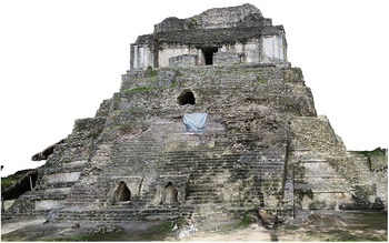
In 1987, INAH’s archaeologist Enrique Nalda, initiated the first large-scale excavations at Dzibanche, Kohunlich, and Ichkabal (Nalda Reference Nalda and Morlet2000; Nalda and Balanzario Reference Nalda and Balanzario2001–2009, Reference Nalda and Balanzario2010; Nalda and Balanzario Granados Reference Nalda and Granados2014; Nalda et al. Reference Nalda, Campaña and López1999). His excavations, while extensive, focused on only a few of the major buildings at Dzibanche and its residential zone. This research revealed a distinctive architectural style associated with the dynasty combining tall roof combs, exterior walls decorated with semicolumns, and Teotihuacan-style talud-tablero terraces (Figure 2; Nalda and Balanzario Granados Reference Nalda, Granados and Stuardo2008).
The Cormoranes pyramid platform is decorated with talud-tablero and temple walls with double semi-columns. The three open tombs were covered by a late stairway, later demolished (image from photogrammetry by Francisco Estrada-Belli). (Color online)

Dzibanche/Kaanu’l’s Urban and Peri-urban Settlement Features
In the settlement zone to the north and east of the urban core, Nalda (Reference Nalda and Morlet2000:65) noted an extensive zone of walled enclosures that he believed represented land partitions. These enclosures range in size between 0.5 and 1.0 ha near the urban zone and have long been associated with household agriculture (e.g., Hutson et al. Reference Hutson, Hare, Stanton, Masson, Barth, Ardren and Magnoni2021; Turner Reference Turner1974). Their average area increases in the outer, less densely settled areas to 2 ha or more in some cases (Figure 3). The absence of such features and spaces for cultivation within Dzibanche’s urban zone (Figure 4) further supports the notion that agricultural fields in the peri-urban and rural zones, including wetland cultivation, likely supported the population of adjacent urban centers (Canuto et al. Reference Canuto, Estrada-Belli, Garrison, Houston, Acuña, Kováč and Marken2018).
Lidar map of Dzibanche’s urban core. Key: structures (red), causeways (white), field enclosures (green lines), monumental reservoirs (green polygons), wetland fields (blue), and central market (yellow oval) (lidar data by INAH, digital features and image by Francisco Estrada-Belli). (Color online)

Structure density zones and upland (green lines) and wetland (blue lines) features identified on lidar maps in the Dzibanche/Ichkabal survey zone. The two upper categories of urban and urban core used in Canuto et alia (Reference Canuto, Estrada-Belli, Garrison, Houston, Acuña, Kováč and Marken2018) have been conflated for simplicity (lidar data by INAH image by Francisco Estrada-Belli). (Color online)

Dzibanche’s settlement occupies an upland ridge surrounded by two seasonal wetlands. The Cerro de la Tortuga stands halfway between Dzibanche and the large Preclassic center of Ichkabal. A lidar survey carried out in 2017 for INAH over a rectangular area of 103 km2 revealed several causeways connecting the two major monumental centers with other minor ceremonial plaza groups and associated settlement clusters as far east as Mario Ancona 15 km to the northeast of Dzibanche, and Pol Box, the seat of a separate Early Classic kingdom, 12 km to the southwest (Balanzario and Estrada-Belli Reference Balanzario and Estrada-Belli2021; Estrada Belli et al. Reference Belli, Francisco and Velásquez2024). El Resbalon, located 15 km to the north and not connected by causeway, was an early Kaanu’l vassal as well.
Additional causeways formed a network of well-connected minor ceremonial centers around Dzibanche. We believe that the Kaanu’l heartland may have extended further afield to include the minor centers of Nicholas Bravo, Gonzales Ortega, and Ucum about 30 kms away, based on similarity in ceremonial architecture.
Quantitative analysis of the 2017 lidar-derived structure data provides a preliminary baseline to place Dzibanche in a comparative context with Tikal, one of the largest Classic Maya cities for which compatible data are available. The 2017 lidar-derived structure data show the highest density ranging between 300 and 797 strs/km2 around Dzibanche’s four monumental complexes (Figure 4). This urban zone measures 15 km2 in area, while Tikal’s urban-density zone measures 11 km2, with a peak spot density of 550 strs/km2 (Canuto et al. Reference Canuto, Estrada-Belli, Garrison, Houston, Acuña, Kováč and Marken2018:Table 8).
Overall, there are 13,928 structures in the 103 km2 Dzibanche lidar survey resulting in an average overall density of 136 strs/km2. By comparison, in an equivalent area of the 2016 lidar survey of Tikal we identified 9,347 structures and an average density of 91 strs/km2. As shown in Table 1, the topography of Tikal includes primarily uplands suitable for settlement. In the Early Classic period, Dzibanche was apparently much denser and more populous, with a population between 36,000 and 55,000 estimated with standardized parameters widely used in pre-lidar surveys (Canuto et al. Reference Canuto, Estrada-Belli, Garrison, Houston, Acuña, Kováč and Marken2018:Tables 5 and 8). In both cases broader lidar coverage will be necessary to assess the full extent of each city.
Dzibanche and Tikal’s Structure Density and Population Estimates Compared (when considering only upland terrain, Dzibanche exhibits approximately three times the structure density of Tikal).

Based on Nalda’s and more recent excavations by Balanzario, Dzibanche reached its peak in construction activity in the monumental and residential areas in the mid-seventh century, until AD 636 when the dynasty moved to Calakmul. Tikal, however, did not reach its population peak until AD 700–750. Based on what is known today about Tikal’s Early Classic settlement and monumental zone, it was significantly smaller than Dzibanche during that period.
A direct comparison of Dzibanche’s Early Classic and Tikal’s Late Classic monumental zones and causeway systems reveals similar triangular layouts but also a staggering difference in scale of 2:1 (Estrada Belli et al. Reference Belli, Francisco and Velásquez2024:Figure 6). The Dzibanche layout dates to the Early Classic so it is likely that Tikal’s Late Classic (AD 600–900) triangular causeway-and-monumental complex layout may have been inspired by the rival city plan.
Dzibanche had at least one major market, identified by a collection of elongated low-profile platforms arranged in parallel rows at the terminus of the Avenue of the Kings, the 100 m wide causeway entering the Main Group (Figure 3; Estrada Belli et al. Reference Belli, Francisco and Velásquez2024:Figure 8). Two ball courts were adjacent to it. In addition to this central point of exchange for the city, there were several large elite plazas scattered throughout the hinterland that may also have served as local markets.
Recent lidar-aided settlement analyses at Caracol and elsewhere in the Maya Lowlands have revealed networks of plaza groups that may have functioned as marketplaces hosted by local elites, as well as administrative centers (Chase et al. Reference Chase, Chase, Chase and Scott2020; see also Ruhl et al. Reference Ruhl, Dunning and Carr2018). Around Dzibanche there are 17 plaza groups that qualify as potential district marketplaces with large plaza areas, elite architecture, ball courts, causeways, and associated settlement clusters.
Within the 2017 survey zone, 91% of the population resided within 2 km of a large plaza group, allowing for daily access (Figures 4 and 5). The surrounding land parcels, averaging 1 ha, were arranged in radiating patterns, suggesting the elite may have played a role in land allocation within their settlement clusters or neighborhoods
The elite plaza group of Mario Ancona with possible market next to the plaza, associated clustered settlement, and upland and wetland fields. (Color online)

Finally, Dzibanche’s remarkable urban planning is further highlighted by the spatial distribution of its monumental reservoirs. Across the entire surveyed settlement, 100% of the population lived within 1.5 km of one of 36 monumental reservoirs. This suggests that the reservoirs, averaging 4.5 ha in area, were built to supply water for the entire community, not just the urban elite as may have been the case at Tikal (Scarborough and Gallopin Reference Scarborough and Gallopin1991:661). Constructing these required the coordination of massive labor efforts.
Conclusions
INAH’s 2017 lidar survey reveals that the Kaanu’l capital may have been the largest urban settlement in the Maya Lowlands in the Early Classic period. While long-lived, the city and settlement were left relatively unchanged by later occupation. As Nalda’s excavations showed, only part of the monumental zone continued to be occupied in the Late Classic and even sporadically in the Postclassic periods. The settlement zone did not see much architectural overburden nor modification in later periods. This fortunate circumstance reveals several features designed to optimize access to resources and services (e.g., markets, ceremonial plazas, causeways, and reservoirs) not only in the urban zone but also throughout the hinterland in ways that are rarely so clear at other sites. The city’s urban planning hints to a relatively more prominent role played by the Maya elite in managing people and resources in and around the urban center than previously thought (see also Estrada-Belli et al. Reference Estrada-Belli, Gilabert-Sansalvador, Canuto, Šprajc and Fernandez-Diaz2023).
Acknowledgments
We are grateful to INAH’s Consejo de Arqueología and the Centro INAH Quintana Roo for authorizing and supporting the various research projects summarized in this article.
Funding Statement
The work reported in this article was financed by INAH, Mexico.
Data Availability Statement
Lidar and lidar-derived data presented in this work are available in accordance with the norms set by INAH-Mexico regarding access to archaeological data owned by INAH.
Competing Interests
The authors declare none.


 Open access