Causewayed enclosures are well known across Europe, with many located in Germany, Denmark, Portugal and the UK (Hedges et al. Reference Hedges, Buckley, Bonsall, Kinnes, Barrett, Drury, Wadhams, Cartwright, Hubbard, Evans and Wilkinson1978; Andersen Reference Andersen2004; Meyer & Raetzel-Fabian Reference Meyer and Raetzel-Fabian2006; Valera Reference Valera2008). Relatively few are in Eastern Europe and none were previously known in Ukraine. Recent fieldwork on the island of Khortitsa, however, has identified the site of Generalka 2 as a causewayed enclosure (Tuboltsev & Radchenko Reference Tuboltsev and Radchenko2018). This discovery expands the geographic range of causewayed enclosures to the Ukrainian Steppes, and raises the question of whether there may be more of these sites even farther east.
The discovery of Generalka 2 leads us to believe that the absence of causewayed enclosures in Ukraine may be a result of difficulties in identifying these sites. Unlike Germany, Poland or Hungary (Tomas & Javorski Reference Tomas, Jaworski and Godliewski2013), aerial photogrammetry has not yet been used to identify causewayed enclosures in Ukraine. The process of site identification is also hampered by the similarity between the natural soil and the fill of the ditches, making it very difficult to distinguish between the two. Consequently, identifying a site demands a commitment to long-term research.
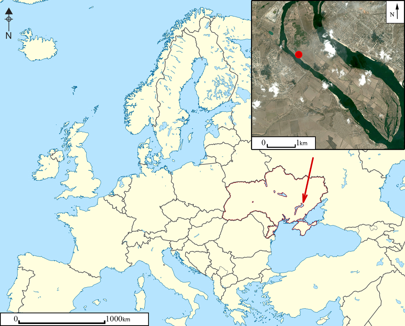
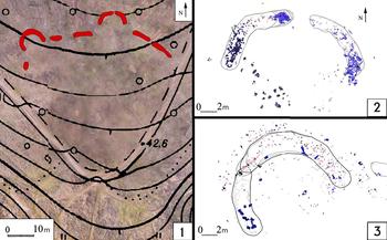
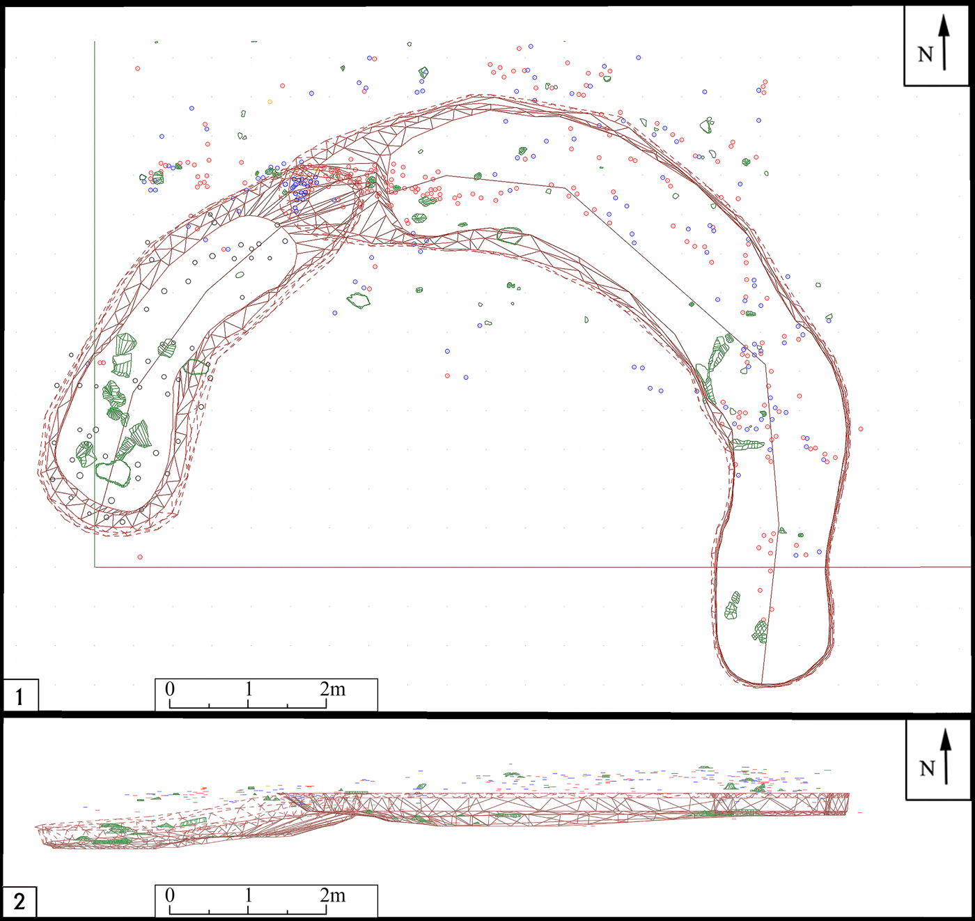
Generalka 2 is on the island of Khortitsa, the biggest river island in Europe (Figure 1), located in the River Dnieper. It lies on a small (0.7ha) subtriangular promontory, formed by the high riverbank and a steep ravine (Figure 2). The site is separated from other parts of the island by segmented ditches that create a curvilinear barrier (Figure 3.1) and consists of two cultural levels that belong to the Early Bronze Age. According to faunal remains and the ceramic assemblage discovered in what seem to be floor levels, the upper level appears to be a settlement (Kaiser Reference Kaiser2010). Samples of cattle bone used for radiocarbon analysis returned a date of 4190±35 BP (Poz-67457: 2817–2666 BC at 95.4% confidence; date modelled in OxCal v.4.2.3 using IntCal13 calibration curve; Bronk Ramsey Reference Bronk Ramsey2009; Reimer et al. Reference Reimer2013); this suggests that the site belongs to the Yamnaya culture.
Location map (figure by Simon Radchenko).

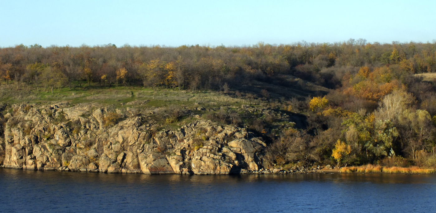
The site of Generalka 2 as viewed from the west (photograph by Oleg Tuboltsev).
The island promontory showing the location of ditches that form the curvilinear barrier: 1) general layout of the site; 2) northern semi-rondell; 3) north-western semi-rondell (figure by Oleg Tuboltsev).
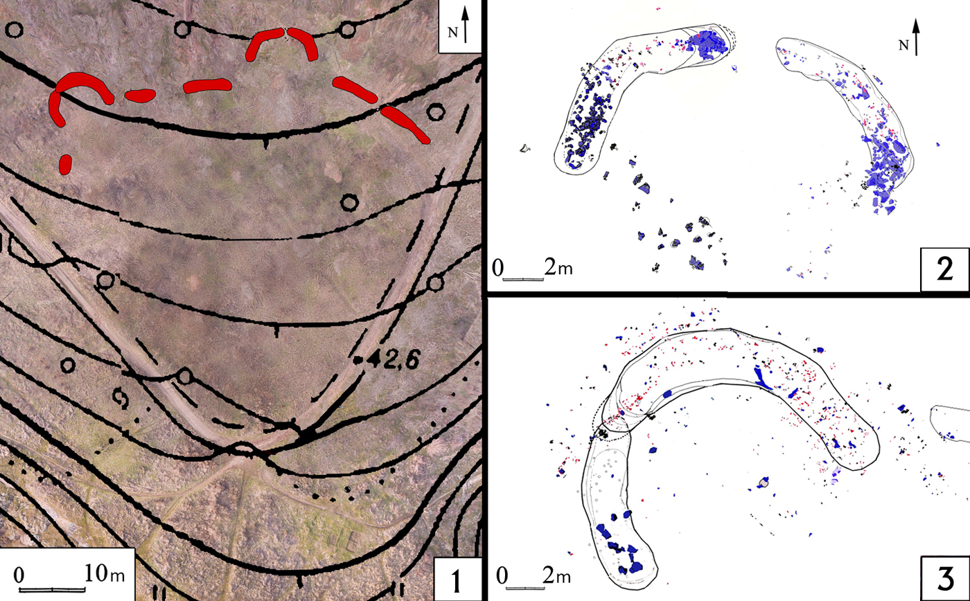
The lower level is dated by a cattle bone to 4326±28 BP (OxA-23080: 3086–2907 BC at 95.4% confidence; date modelled in OxCal v.4.2.3 using IntCal13 calibration curve; Bronk Ramsey Reference Bronk Ramsey2009; Reimer et al. Reference Reimer2013). Finds in this level are concentrated close to, and in the fill of, the ditches; most were near the bottom and seemed to be structural deposition. The ditches enclosing the site appear contemporaneous with this phase of use; they include semi-rondells (semi-circular segments) formed by two overlapping cuts, with the former oriented to the north and north-west (Figure 3). About 60 postholes were also discovered within the ditches and following their contour. As with those at Western European causewayed enclosures (Harris Reference Harris2003; Pollard Reference Pollard and Gibson2012), the ditches contained significant objects including a human skull, pebbles and a sacrificial stone, which indicate a ritual function for the site.
The ceramic assemblage includes more than 170 vessels that fall into one of two broad groups reflecting the two phases of the site (Tuboltsev & Radchenko Reference Tuboltsev and Radchenko2018: 129, fig. 9). The ceramics associated with the lower layer are mostly close to or within the ditches, while those associated with the later level are distributed across the site.
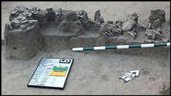
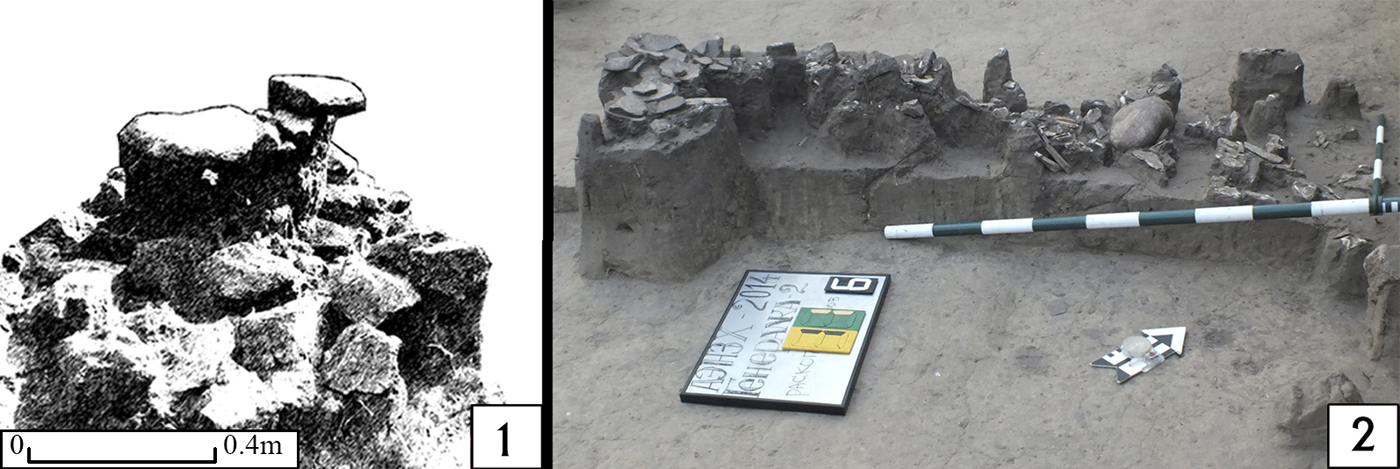
Significant finds, such as a jawbone and a sacrificial stone, appear to concentrate at the intersections of the semi-rondell segments (the northernmost and north-westernmost points of the site). Deposits of stone were found in the northern semi-rondell ditches and on their surface; the ‘sacrificial stone’ and a fragment of human jaw were located at the northern point of this semi-rondell (Figure 4). Cattle bones (mostly ribs) were concentrated at the bottom of the north-western semi-rondell; at the bottom edge of the ditch was an assemblage including a large pebble, bones and two broken ceramic vessels (Figure 4).
The sacrificial stone (left) and the finds assemblage at the bottom of the north-western semi-rondell (right) (figure by Oleg Tuboltsev).
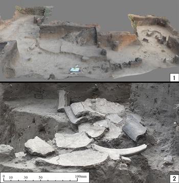
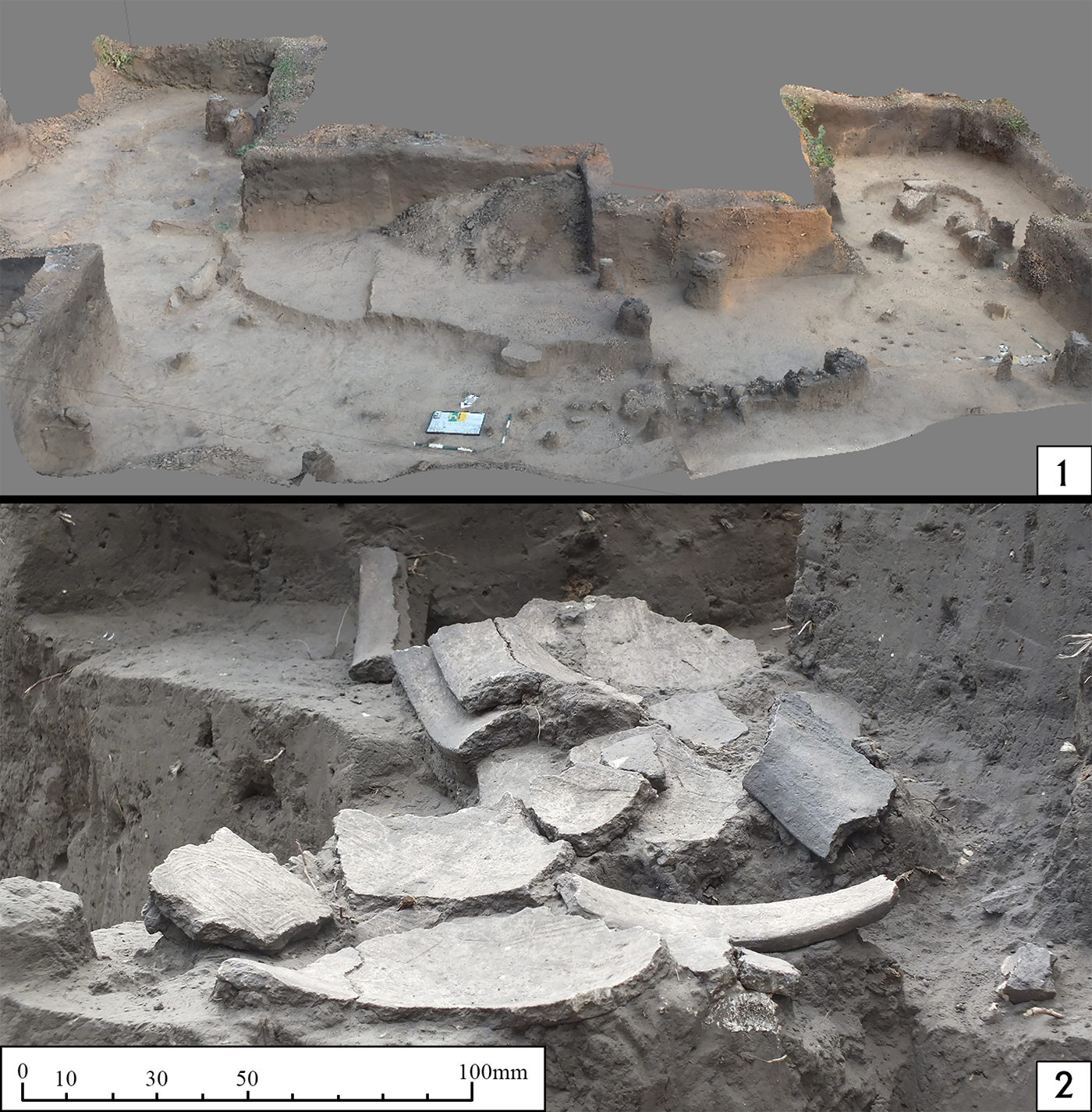
Interpretation of Generalka 2 is fraught with stratigraphic difficulties. The fill of ditches is very similar to the natural chernozem and plagued by burrowing activity, which complicates the process of interpretation. The shape and upper contours of the ditches cannot therefore be easily identified, and are reconstructed from numerous stratigraphic profiles and GIS mapping; this is time-consuming. A 3D model of the north-western semi-rondell (Figure 5.1) reconstructs the shape of the ditches and shows the location of the finds assemblage (Figure 5.2). Numerous postholes indicate the existence of palisade.
1) 3D model of the excavated north-western semi-rondell; 2) detail of the two ceramic vessels found in situ (figure by Simon Radchenko).
A 3D GIS model also reveals that while U-shaped ditch segments were separate at their deepest point, they overlapped one another at surface level, creating the semi-circular ditch feature (Figure 6). Two ceramic vessels were located at the point of this overlapping (Figure 5.2), which is also the north-westernmost point of the site.
3D GIS-model of the north-western semi-rondell, showing that the ditches were originally separate and then later recut to overlap: 1) plan; 2) profile (figure by Simon Radchenko).
The same phenomenon can be seen in the northern semi-rondell. The distance between ditch segments in the semi-circular ditches is much shorter than between the straight ditches. This forces us to reconsider the idea that semi-rondells were used as entrances to a special area. Instead, entranceways were presumably located between the straight ditch segments.
Generalka 2 shares many similarities with European causewayed enclosures: areas delineated by segmented ditches; astronomical orientation of some ditch elements; the ritual character of finds; the landscape and its topography. All are aspects associated with causewayed enclosures in Western Europe (Whittle Reference Whittle1996; Harris Reference Harris2003). This is compelling evidence that the Gerneralka 2 site is the first-known causewayed enclosure in Ukraine and, with the exception of sites in the Caucasian mountains (Belinskii et al. Reference Belinskii, Fassbinder, Reinhold, Gadzhiev, Gmyria and Magomedov2012), the easternmost in Europe. Although sites with interrupted ditches are well known in Ukraine—from Trypillian sites such as Maidanetske, Nebelivka or Kamyane Zavallia 1 (Saile et al. Reference Saile, Posselt, Dębieç, Kiosak and Tkachuk2016)—Generalka 2 differs in several key ways: the site is smaller; it has clear ritual associations; there is relatively little material culture, and what finds there are can be seen as structured deposits within the ditches. There is also a clear distinction between the Trypillian farmers from the western and central Ukraine and the Yamnaya culture at Gernalka 2.
The fact that Generalka 2 was only understood after highly detailed stratigraphic recording, long-term excavations and use of GIS technologies highlights the problematic nature of identifying causewayed enclosure sites in Eastern Europe. It is probable that the dearth of known causewayed enclosures in Ukraine is due to the difficulties in identifying the complexities of sites in this region and the lack of similar interpretations of ditch chronologies. The Generalka 2 study offers a new methodology for investigating well-known Early Neolithic and Bronze Age sites in Ukraine, such as Molyukhiv Bugor (Neradenko Reference Neradenko2009). The complete excavation of Generalka 2 is a long-term project that has only just begun, but will continue to reveal aspects of the site in the future.