


Introduction
Most rural settlements of the Early Iron Age in Central Europe were small in scale and were not physically demarcated from the surrounding countryside. Yet a characteristic feature of settlements from the Hallstatt period (c. 800–475 BC) is the rectangular farmstead enclosed by a palisade and/or one or more ditches. These lightly fortified estates are often referred to as ‘Herrenhöfe’; probably best translated as ‘manorial farmsteads’, this term was originally used in reference to early medieval forms of landlordship in rural areas of Germany. Despite these associations, the term Herrenhof is used with great persistence in Iron Age research and should also serve here as a familiar and brief terminus technicus.
Such complexes, usually covering an area of less than half a hectare, are often regarded as the residences of high-status farmers (for the first time in Bersu Reference Bersu1927: 106; Pätzold & Schwarz Reference Pätzold and Schwarz1961: 14–15; Christlein Reference Christlein1981: 86) and so form a key component of the discussion surrounding Hallstatt social structure. Little evidence for social distinction has been identified in Early Iron Age settlement contexts in Central Europe; spatial segregation of living spaces according to status is lacking, and the differentiated ornamentation of burials remains the most recognisable source of information on social organisation.
Drawing on new results from excavations at Landshut-Hascherkeller in Bavaria, this article re-evaluates the significance of rectangular farmsteads for our understanding of social structuring during the Hallstatt period, when early Celtic-speaking peoples maintained close contacts with the Mediterranean world. Moving beyond the widespread focus on elite burials, a rural-settlement-related perspective is adopted here to explore the Herrenhöfe as expressions of modest social status set in a geographic nexus between hierarchical-centralising and segmenting-anarchistic models of Hallstatt social organisation. The placement of Early Iron Age farmsteads is also considered with regard to the long-lasting impact of earlier landscape use.
When the first homestead of the Herrenhof type was excavated on the north-eastern edge of the Goldberg plateau near Nördlingen (Württemberg) by Gerhard Bersu in 1926, the excavator described it as “a princely palace” (“Fürstenpalast” in Bersu Reference Bersu1927: 106). Herrenhöfe were later also unearthed in Oberhaching, Kirchheim and Landshut-Hascherkeller, which were interpreted as the seats of a presumed Hallstatt gentry. Evaluation of a rectangular farmstead in Linzing, on the other hand, led Klaus Leidorf (Reference Leidorf and Engelhardt1985: 135) to the conclusion that the structure was simply an average agricultural settlement without any overt indicator of social status for the inhabitants. Rather than being set apart, Leidorf argued that the enclosed, rectangular multi-house residential complex should be considered the standard form of the Hallstatt single farmstead. However, Herrenhöfe at Geiselhöring and Niedererlbach reveal seemingly prosperous agricultural settlements that also possessed mercantile importance for the logistics of the movement of goods. Subsequent debate demonstrates the wide range of possible interpretations for these Early Iron Age complexes (Kas & Schußmann Reference Kas, Schussmann, Berthold, Kahler, Kas, Neubauer, Schmidt and Schußmann1998: 104; Nagler-Zanier Reference Nagler-Zanier1999: 96; Müller-Depreux Reference Müller-Depreux2005: 121; Schumann Reference Schumann2015: 275–77).
Since the first discoveries, the number of rectangular farmsteads has increased substantially, with aerial photography providing a particular boost to research since the late 1970s. In contrast, the number of sites has grown only slightly in recent decades, indicating that this archaeological object group is increasingly depleted. The distribution of the approximately 150 known sites (Figure 1; Berg-Hobohm Reference Berg-Hobohm2002/2003: 171–89; Geelhaar & Faßbinder Reference Geelhaar and Fassbinder2014: 193–94) displays a spatial concentration in Lower and Upper Bavaria and the Upper Palatinate, including a cluster on the Landshut Loess Terrace (Figure 2). The actual number of localities is likely to be over 200, though the overall picture is unlikely to change substantially. Herrenhöfe have also been recorded in Franconia and Bohemia, and ‘établissements ruraux palissadés hallstattiens’ (Hallstatt palisaded rural settlements) are known from the western periphery of the Hallstatt world in Champagne (Desbrosse & Riquier Reference Desbrosse, Riquier, Schönfelder and Sievers2012). Other Iron Age enclosures, including examples from the Atlantic façade of Europe (Ralston Reference Ralston2006) and the quadrangular enclosures (‘Viereckschanzen’) of the late La Tène period (second and first centuries BC), are unrelated to the Hallstatt rectangular farmsteads, even if some of them seem to show a similar desire for spatial separation (Venclová Reference Venclová, Harding, Sievers and Venclová2006).
Distribution of rectangular farmsteads, so-called Herrenhöfe, between Champagne and Bohemia (figure by H. Marx).

Rectangular farmsteads on the Landshut Loess Terrace. 1) Altheim, ‘Andreasweg’; 2) Altheim, ‘Holzen 1’; 3) Altheim, ‘Holzen 2’; 4) Altheim, ‘Holzen 3’; 5) Altheim, ‘Holzen 4’; 6) Altheim, ‘Holzen 5’; 7) Ergolding, ‘Siechenhausfeld A’; 8) Ergolding, ‘Siechenhausfeld B’; 9) Essenbach, ‘Altheimer Feld’; 10) Kopfham, ‘Galgenberg B/C’; 11) Kopfham, ‘Galgenberg D’; 12) Landshut, ‘Hascherkeller’; 13) Landshut, ‘Kellerberg’; 14) Mirskofen I; 15) Mirskofen II; 16) Pettenkofen (figure by H. Marx).

Given the large number of Hallstatt-period sites in general, Herrenhöfe represent a rather rare category and are only encountered in about one in every 15 settlements. Only about one-third of the rectangular farmsteads have been excavated (mostly partially), but a rather low degree of standardisation in the construction of these enclosures is becoming apparent. Most were laid out on the edge of terraces, though other relief positions are also known, and they tend to be located near watercourses or along routeways. Predominantly found in favourable agricultural areas, they generally occupy prominent positions in the landscape and their distribution in relation to fertile soils has been described as loess-bound. Spatial associations with groups of burial mounds seems to be a characteristic trait (Augstein Reference Augstein2015: 290–303).
Previous excavations and magnetic prospecting at Hascherkeller
The loess soils erode very rapidly when subjected to intensive cultivation. At Hascherkeller, a large part of the topsoil on the sloping farmland has been washed away. This makes the dark backfilling of the archaeological features in the yellow loess visible to the interested observer.
The enclosing ditches at Hascherkeller were spotted during an aerial photography flight in 1977. Situated on the edge of the loess-covered lower terrace, the site overlooks the broad valley of the Isar River at an elevation of about 15m above the river surface. Excavations were conducted between 1978 and 1981 in the western area of the site by the Peabody Museum (Wells Reference Wells1983, Reference Wells and Bogucki1993), and in the eastern area by the Bavarian State Office for the Preservation of Historical Monuments (Becker et al. Reference Becker, Christlein and Wells1979). The field in between was magnetically surveyed, producing the first ever magnetic image of a complex enclosed Hallstatt settlement (Figure 3). The combined excavation and magnetic survey led to the interpretation of three contiguous rectangular farmsteads at Hascherkeller (Herrenhöfe A–C), each about 55m across (Wells Reference Wells1983: 134).
Landshut-Hascherkeller (Lower Bavaria). Archaeological features, mostly ditches and pits, discovered during three magnetic surveys. The 1978 magnetogram (Becker) has been superimposed upon the 2019 prospection (Faßbinder), as the latter was partially obscured by rows of planting pits of a tree nursery. Prospecting of the large northern area took place in 2021 (Posselt) (figure by M. Posselt).

Resumption of archaeological explorations
Despite identification of the cultural-historical significance of the site, the central part of the complex has been used as a tree nursery since the early 1990s. As a consequence, most shallow archaeological structures were destroyed, leaving only the lower parts of ditches and pits dug deep into the underlying loess subsoil. Magnetic prospection was resumed in 2019 preceding a construction project and continued in 2021 in an adjacent area to the north (Figure 3). Excavations were also conducted over an area of approximately 8500m2 between 2020 and 2022 (Figure 4).
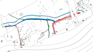
Landshut-Hascherkeller (Lower Bavaria). General plan of the excavations carried out in the western and eastern parts of the site (1978–1981) and in its central area (2020–2022). The location of selected profiles (1–4) for stratigraphic disentanglement of the ditches is also shown. The palisade ditch P of farmstead A and the dividing ditch I (both green, see Figure 5, no. 1) are spatially separated from the two rectangular enclosures, B and D (older phase in dark red, younger phase in light red, see Figure 5, nos. 2–4), which were later integrated into a larger settlement complex by two connecting ditches (earlier phase in dark blue, later phase in light blue, see Figure 5, nos. 1, 3 & 4). The previously postulated Herrenhof C never existed as a stand-alone structure (figure by H. Marx).

The main objective of the recent excavations was to unravel the sequence of the numerous ditches. These have a maximum width of about 3m at the top and extend to a maximum depth of about 1.5m into the loess. Ditch cross-sections are mostly V-shaped. No causeways that could have acted as access points were observed, and no statements can be made about the appearance of any ramparts, which were probably constructed from the material dug from the ditches. The ditches delimit the rectangular enclosures, representing the essential structural features of the entire Hascherkeller complex. Near but spatially distinct is a palisaded farmstead to the east (Figure 4A) and, as a third independent element, a ditch running across the study area (Figure 4I).
Settlement pits were observed primarily in the southern part of the excavation area (Figure 4). Some long, narrow pits may have been earth cellars beneath houses, indicating the possible location of a building (Knoll Reference Knoll2018: 142, fig. 146). In the north-eastern section, several rows of postholes were discovered. These probably delimit the more or less complete ground plans of houses, but loss of the original surface has stripped away evidence of the chronology and function of the structures.
The sequence of ditches
Some stratigraphic observations from excavation of ditch profiles allow for temporal disentanglement of these features (Figure 5). This provides a general overview of the development of the site. Contrary to previous assumptions, the new excavation results indicate that the postulated Herrenhof C never existed as an individual structure; there were never three contiguous earthen enclosures. Instead it is plausible that the farmsteads developed chronologically from east to west (Figure 6): palisaded farmstead A (phase 1), rectangular ditched enclosures B and D (phase 2) and settlement complex B/D (phase 3).
Ditch profiles from Landshut-Hascherkeller reveal the relative chronology of the site. Ditch I is intersected by ditch IV (profile 1); the substantial backfill of wall plaster was already visible as a particularly strong anomaly on the 1978 magnetogram. Ditch IIa is intersected by ditch IIb (profile 2). Ditch IIIb is overlapped by ditch IV (profile 3). Ditch IIa is intersected by ditches IIb and IV (profile 4). See Figure 4 for the location of profiles at the site (figure by H. Marx).

Schematic sequence of ditch construction at Landshut-Hascherkeller. A distinction is made here between six settlement phases, each with recently laid-out (red) and still visible ditches from earlier phases (light red) (figure by H. Marx).

The ‘archaic’ palisade P was built on a settlement of the Urnfield period (c. 1300–800 BC), from which farmstead A probably emerged in a process of separation (phase 1b). Only parts of the palisade fence have been excavated (Becker et al. Reference Becker, Christlein and Wells1979: 291, fig. 3, pl. 48.1). At this time, ditch I may have already existed (phase 1a). This ditch runs through the investigated area in a curved course of more than 200m (Figure 3) providing a demarcating, separating feature that emphasised a territorial boundary. At the very latest, ditch I could have been dug when the farmsteads B and D were already established, as ditch IV (which was constructed later to enclose both farmsteads) intersects ditch I (Figure 5, no. 1).
Enclosure B was most likely erected prior to farmstead D, as its massive ditch II shows re-cutting, indicating a longer duration of use. The re-digging was often slightly off-centre, so that two overlapping ditch features are visible (Figure 5, no. 2). Palisade A was probably no longer visible at this point (phase 2a). Both enclosures respected the course of the presumably older ditch I. Re-excavation of the relatively small ditch III surrounding farmstead D was not undertaken, possibly reflecting a shorter duration of use, though the farmstead appears to have been intended to correspond largely in size to farmstead B. In the later phase of enclosure B, they may have existed concurrently (phase 2b).
The two enclosures B and D, which are about 75m apart, were ultimately connected by a double ditch system to form a single larger settlement (Nagler Reference Nagler1993: 59). Since ditch IV partly follows the course of ditch I, this earlier ditch must have been perceptible at the time ditch IV was dug (phase 3a), though it may not have persisted in the final phase 3b of the farmstead complex. Ditch IV runs from west to east (Figure 4), first following the course of the northern part of ditch III (Figure 5, no. 3) and then a short section of ditch I (Figure 5, no. 1) until it reaches ditch II (Figure 5, no. 4). Ditch IV is younger than the renewed excavation phase of enclosure B (ditch IIb). Ditch V forms part of the northern facade of the double enclosure, it runs parallel to ditches IV and IIb at a distance of approximately 5m for a length of about 210m and bends towards the south at both ends. This ditch was probably built in connection with the construction of ditch IV or shortly thereafter.
The terrain sloping down towards the south does not reveal the further course of the ditches; soil erosion on a steep slope presents a similar impairment of ditch structures at Niedererlbach (Müller-Depreux Reference Müller-Depreux2005). It is conceivable, however, that farmsteads B and D were originally roughly square in layout.
The chronological setting
The edge of the Landshut Loess Terrace was a favoured location for Urnfield settlement activities (Koch & Richter Reference Koch and Richter2012), and there is evidence for a large Urnfield settlement at Hascherkeller. In this respect, the occurrence of Urnfield finds in several of the excavated Hallstatt features is not surprising and may be disregarded for the purposes of dating these features.
The relationship between the row of posts of enclosure A and the ground plans of the houses on the eastern edge of the excavated area has been debated (Becker et al. Reference Becker, Christlein and Wells1979: 291; Wells Reference Wells1983: 13, 129). Re-examination of the original excavation report suggests that no stratigraphic superpositions were found. Since the palisade was erected on the terrain of a large Urnfield settlement, it can be assumed that an Urnfield farmstead was enclosed and separated off from the rest of the settlement. Later this farmstead became the predecessor of the ditched Hallstatt complexes located to the west of it.
By the time the ditches were dug, the area of the settlement had been inhabited for an extended period. The ditches were apparently kept in good condition and partly re-excavated. Consequently, finds from the backfilling of the ditches are only useful in sketching out a broad date for their construction and use. The most recent identifiable materials date from the earlier Hallstatt period (eighth and seventh centuries BC). The ditch system, forming the Hallstatt enclosures during a second principal period of activity at the settlement site, is therefore likely to have endured for just a few generations.
Neighbouring places
Near Landshut, the Tertiary hilly landscape to the north-west of the Isar River curves northward in a form resembling a bay. The loess-covered terrace in front of it, between the gently sloping hills and the river, represents a core area of the Herrenhof distribution (Figure 2), but is also some of the oldest settled land in the region.
About 200m south-west of Hascherkeller, a magnetic prospection at the Kellerberg revealed two neighbouring, enclosed Hallstatt farmsteads (Figure 7), which appear to have been later joined together by connecting ditches to form a larger complex (Becker & Leidorf Reference Becker and Leidorf1987: 74, fig. 44, no. 5). The length of the north-western sections of the enclosure ditches of both farmsteads, each just under 55m, corresponds closely to the observations made at Hascherkeller. In addition, both structures are located on the edge of a terrace sloping down to the south. A connection between the two Herrenhof complexes may also have existed through ditch I of Hascherkeller, the course of which turns to the south-west. These structural comparisons and potential connection make similarities in the respective dates of these sites appear very likely, and a comparable social interpretation suggests itself.
Landshut (Lower Bavaria). Showing the proximity of the Hascherkeller (right) and Kellerberg (left) sites (figure by M. Posselt).

Further away, about 5km north-east of Hascherkeller at the Eichelbach between Holzen and Altheim, a group of Hallstatt rectangular farmsteads was magnetically prospected in the course of the investigations on the Late Neolithic earthworks of Altheim from the thirty-seventh/thirty-sixth centuries BC (Saile Reference Saile, Uthmeier and Mischka2023). These considerably expand understanding of farmstead complexes (Figure 8).
Altheim (Lower Bavaria). The Early Iron Age rectangular farmsteads Holzen 1–5 (red) and the Late Neolithic earthworks Altheim I and II (green) on the Landshut Loess Terrace north-east of the Isar River. Holzen 2, 3 and 5 are located to the west of the Eichelbach stream; Altheim I and II as well as Holzen 1 and 4 are situated to the east (figure by M. Posselt).

Up to four staggered ditches surround the possibly never completed rectangular complex of Holzen 1 (63 × 50m) to form an architectural design that can be understood as a prestigious facade with an entrance of considerable size in the north-west (Becker Reference Becker1987: 80; Kas & Schußmann Reference Kas, Schussmann, Berthold, Kahler, Kas, Neubauer, Schmidt and Schußmann1998: 99). On the adjacent settled area, several pits measuring about 1 × 7m can be recognised; numerous others are distributed over the entire area of the magnetogram. This particular type of long, narrow pit is regularly oriented north-west to south-east, which might be taken as an indication of the orientation of the associated houses. They show a spatial concentration on the Landshut Loess Terrace and possibly represent a form of earth cellar characteristic of the region. However, similar pits in the preceding Urnfield period are often associated with the sites of looms (Zuber Reference Zuber, Chvojka, Kuna and Menšík2021).
Holzen 2 has narrow ditches and a multi-part appearance. The maximum north-west to south-east extension is almost 120m. It is possible that the northern enclosure, with an area of 3320m2, is the oldest structure, which then undergoes extensions to the south and the west. Similarities in terms of form and development are found in the early Hallstatt complex of Geiselhöring (Nagler-Zanier Reference Nagler-Zanier1999). If the palisaded enclosure is seen to emerge as a means of physical and symbolic separation in Urnfield settlements (Kas & Schußmann Reference Kas, Schussmann, Berthold, Kahler, Kas, Neubauer, Schmidt and Schußmann1998: 104; Kas Reference Kas2006: 102–12; Augstein Reference Augstein2015: 296, fig. I.51), as appears to be the case at Hascherkeller, then Holzen 2 could be the oldest Herrenhof in the Eichelbach group.
Holzen 3 is characterised by a double ditch with a titulum, a short defensive ditch located in front of the entrance area. The interior covers only 2246m2 and the remains of a palisade ditch and three probably concurrent long, narrow pits are visible.
Holzen 4 was disturbed by a large pit complex to the east and is only partially preserved. A single ditch encompasses three long, narrow pits that probably existed at the same time as the enclosure. The ground plan of a structure consisting of possibly 12 posts with stronger corner posts in oblong pits is visible immediately to the south-east of the Herrenhof.
Only 8m north of Holzen 2 and partly hidden by the tracks of a railway line, lies the small rectangular enclosure of Holzen 5 (2835m2). It is the only Herrenhof in the Eichelbach group to have been excavated so far (Saile et al. Reference Saile, Posselt, Reitmaier and Tinapp2021). The investigation revealed evidence of a ditch, 2.2m wide and 1.1m deep, that was heavily affected by soil erosion processes. The prevailing direction of inflow of the soil substrate indicates that the accompanying rampart was positioned inside the ditch.
The Hallstatt farmsteads of the Eichelbach group occupy a crescent formation to the west of the Late Neolithic Altheim enclosures (I and II), whose ditches were probably still visible in the Early Iron Age. The presence of a Middle Bronze Age flat grave from the phase Bz B1 (sixteenth century BC) and a group of Urnfield burials probably also marked the area around the Late Neolithic enclosures as unsuitable for settlement. It is quite possible that the site was used as a burial ground in the Hallstatt period, as indicated by the tumuli enclosure ditches that can be seen to the east of the Altheim II earthwork on the magnetic image (Figure 8). The inhabitants of the Holzen rectangular farmsteads honoured the still recognisable structures of their ancestors. By appreciating the older elements of the cultural landscape, they established links to the past. This facilitated their understanding of the Iron Age present.
The Herrenhof in comparison
The typical Hallstatt farmstead consisted of several buildings that formed an agricultural unit. Some farms were surrounded by enclosing structures and there could have been lively economic competition between them all. The rectangular-ditched farmstead was probably the residence of the head of the farm, their extended family and their retinue, perhaps more than a dozen people in all. In the Hascherkeller example, two neighbouring ditched rectangular farmsteads can be identified, which were later merged into a larger entity. This brings to mind an increasingly intense kinship relationship that eventually coalesced into a single economic unit. A similar architectural manifestation of the integration of two families may also have occurred on the neighbouring Kellerberg.
Rectangular farmsteads are in Hallstatt settlements, but a larger number of settlements existed without such structures. The Herrenhof does not, therefore, appear to have been a necessary component of rural settlements. At the same time, several Hallstatt rectangular farmsteads stand in isolation, with no habitation structures observed beyond the ditch (Kas & Schußmann Reference Kas, Schussmann, Berthold, Kahler, Kas, Neubauer, Schmidt and Schußmann1998: 98, 101).
The Hallstatt rectangular farmstead may have evolved from the Urnfield palisaded enclosure (Schumann Reference Schumann2015: 277), though this assumption is not uniformly accepted (Reichenberger Reference Reichenberger and Buck1994: 199, 213). At least at Hascherkeller, the easternmost palisaded enclosure was such a precursor of the ditch system further west.
The Herrenhof is characterised as a fortified estate expressing rural self-determination in the middle of Hallstatt social ranking (Becker et al. Reference Becker, Christlein and Wells1979: 300). It has frequently been ascribed an essential role in regional craft production and trade. However, there is as yet little material evidence of significant status differences (i.e. distinguishable ranks on a vertical social axis) between the Herrenhof and adjacent areas of the village to which it belongs, or other settlements. Occasionally, artefacts from neighbouring, and presumably associated, burials indicate a slightly elevated standard of living at a Herrenhof (Müller-Depreux Reference Müller-Depreux2005: 115, 120–21), though this is rare. Nevertheless, the ditches delimiting the homestead are themselves an unmistakable sign of demarcation, social distinction and individual autonomy. This becomes more apparent when considering the protective value of the ditches, and their associated ramparts and palisades, which is likely to have been rather low. The inhabitants of the Herrenhof owned their particular social status in the midst of otherwise simple material surroundings.
In some regions, however, the rectangular farmsteads are very close together, which raises the question of their contemporaneity. In such instances, the longevity of the Herrenhof phenomenon and whether it really had its temporal focus only in the later Hallstatt period become key questions. Yet the dating of rectangular farmsteads is difficult; most sites are only known from aerial photographs and/or magnetometer surveys, and pottery inventories are often not conclusive (Schumann Reference Schumann2015: 277, figs. 8.9–10). The issue of the temporal relationships is particularly pressing, for example, in understanding the five rectangular enclosures documented at the Eichelbach near Holzen (Figure 8).
The Herrenhof in the Hallstatt sociopolitical system
Uncertainties exist as to how best to understand the role of the rectangular ditched farmstead in the Hallstatt settlement system and the complexity and stability of the sociopolitical structure of Hallstatt society in general (Schier Reference Schier, Knopf, Steinhaus and Fukunaga2018). The hierarchical character of Hallstatt society is often emphasised (Fernández-Götz & Ralston Reference Fernández-Götz and Ralston2017: 271–72). Power and status were arguably based primarily on land ownership and control of local production, rather than on control of trade (Gosden Reference Gosden1985; but see Nakoinz Reference Nakoinz, Haug, Käppel and Müller2018). Communication and interaction between individuals and groups became more frequent in a growing and increasingly prosperous population. Through their social, political and economic networks, regional groups became integrated into larger collective units (Carneiro Reference Carneiro1967). An elitist code of behaviour, also known as martiality, strengthened the social cohesion of the tribal clientship system (Roymans Reference Roymans and Roymans1996: 13–14). Competition for control over wealth and associated economic and political influence led regionally to the emergence of stronger distinctions and centralised forms of power with hereditary status positions (Krausse & Hansen Reference Krausse, Hansen, Knopf, Steinhaus and Fukunaga2018: 191–92, fig. 13). In addition to the principle of descent, personal charisma likely played an important role (Breuer Reference Breuer2014). These processes culminated in a short-lived wave of centralisation and urbanisation trends (Schumann Reference Schumann2019).
Social differentiation was apparently more pronounced in the west and south-east of the Hallstatt world—with numerous lavishly furnished barrow burials and several regional centres of power and wealth—than in the Herrenhof province in between. Some features associated with the residences of Hallstatt nobility, such as gold objects (neck rings), vessel sets for a symposium and Mediterranean imports, are also not found in the region occupied by the rectangular farmsteads. These items could reflect differentiation in terms of wealth, prestige and the extent of outside contacts, rather than a structured ordering of society (Eggert Reference Eggert2007: 292): an individualising branch of society in contrast to a group-oriented one (Renfrew Reference Renfrew and Runciman2001: 103–4). On the other hand, the considerable population size of the Heuneburg near Hundersingen on the Danube (Württemberg) alone, with resultant intensive communication and interaction between individuals, is likely to have led to more complex social structuring and differentiated status groups than can be expected, for example, for the area covering the Herrenhof distribution.
We argue that the rectangular farmsteads symbolised a rather segmented, acephalous social system, while in the area of the princely seats a more stratified system was implemented as a counterpart. Two distinct political and social systems may therefore have coexisted in the Hallstatt culture, which exhibits a more or less homogeneous material entity across its geographic extent (Jeunesse Reference Jeunesse, Kadrow and Müller2019: 206–7, figs. 33–34). Furthermore, areas where settlements appear modest and undifferentiated and where rich burials are absent seem to be much more common in the European Iron Age. The decentralised power structures of these regions may have functioned according to the segmentary principles of orderly anarchy (Armit Reference Armit, Romankiewicz, Fernández-Götz, Lock and Büchsenschütz2019: 106–7). Signs of destruction in the lands of the Hallstatt principalities and the robbing of sumptuous tombs shortly after their erection testify to internal crises and to the likelihood that the position of the leading groups was not uncontested (Demoule Reference Demoule and Ruby1999: 130).
Concluding remarks
Knowledge of the internal structure of Hallstatt rectangular farmsteads is limited; only a few have been systematically excavated and analysed but it seems that they represent a rather diverse type of settlement. The settlement history of the Herrenhof complex at Hascherkeller is made clearer through careful stratigraphic observations. The merging of two originally separate farmsteads can be viewed as the merging of neighbouring families. Such a process would have led to an accumulation of property rights and individual aggrandisement. This was at odds with the widespread notions of equality held by the acephalous communities, which almost certainly demanded a reduction in acquired wealth, even though farming favours property (Renfrew Reference Renfrew and Runciman2001: 114–15).
In Hallstatt central Europe, enclosure can be regarded as an elitist form of space utilisation. Herrenhöfe may have conveyed complex social messages relating to residential differentiation and spatial segregation. However, these places were not associated with the connotation of a particularly high status. In the ditched and palisaded manorial farmsteads, a prominent farming class can be discerned in its modest prosperity, to which handicraft production and the storage and re-distribution of important products also contributed (Nagler-Zanier Reference Nagler-Zanier1999: 96; Müller-Depreux Reference Müller-Depreux2005: 122). This more segmented society of the Herrenhof province was linked by kinship and reciprocal relationships, and there were evidently mechanisms for collectively regulating living conditions while avoiding institutionalised leadership and any means of coercion (Armit Reference Armit, Romankiewicz, Fernández-Götz, Lock and Büchsenschütz2019: 107–8). However, the early La Tène princely tomb of Irlbach from the middle of the fifth century BC (Husty Reference Husty2024), recently discovered in the area of the former Lower Bavarian Herrenhof province, shows how quickly sociopolitical arrangements could change from an acephalous society to a system in which centralised authorities could impose and enforce physical sanctions.
The spatio-temporal fluctuation between more hierarchical-centralised and more segmentary-anarchistic social and political conditions appears to have been a characteristic feature of prehistoric Europe (Jeunesse Reference Jeunesse, Kadrow and Müller2019: 207–9, fig. 36). Obviously, there were mechanisms that counteracted the accumulation of great power and extraordinary wealth, at least temporarily. The duality of social organisation observed in the Hallstatt period can be paralleled with traditions of social diversity from Southeast Asia, where Edmund Leach (Reference Leach1954) described the dynamic oscillation between a more autocratic and a more democratic model in his seminal work on the social structures of the Kachin peoples in northern Myanmar. The existence of manorial farmsteads alongside the Hallstatt principalities reflects the social complexity of the European Iron Age, in which both a more hierarchical-centralised and a more segmentary-anarchistic social system existed side by side at times.
Funding statement
No specific grants were awarded by any funding organisation for this project. However, the recent fieldwork was gratefully supported by the City of Landshut, the Bavarian State Office for the Preservation of Historical Monuments and the University of Regensburg.


 Open access