


Introduction
The notion that Britain is an ‘island nation’—that its status as an island has always been a defining feature of the British sense of identity—is something of a cliché; it is true, however, that from Shakespeare's evocation of ‘this sceptred isle’ to Churchill's calls to ‘defend our island home’, Britain's insular character has often played a prominent role in constituting the modern national psyche at a general level (Lavery Reference Lavery2005). Equally, it has influenced our archaeological understandings of interaction in the past (Bradley Reference Bradley2007: 1–26). One of the strengths of archaeology in the contemporary world is that it is able to place these assumptions and stereotypes in the context of deep time, often providing a very different perspective or critique. Britain has not, of course, always been an island. Palaeogeographic modelling indicates that Britain was joined to continental Europe until c. 7000 BC (Sturt et al. Reference Sturt, Garrow and Bradley2013: 3972). Archaeology also reveals that becoming an island is not synonymous with isolation. In many periods, connections across the water with the European mainland were regular, intense and—as we will see below—sometimes took unexpected routes.
The period we are primarily interested in here is the Mesolithic, during which Britain's current island status was formed. Prior to its separation from the continent, southern Britain shared many affinities with northern France and the Low Countries in terms of material culture, a pattern first discussed in detail by Jacobi (Reference Jacobi1976). Ghesquière (Reference Ghesquière2012: 107) has recently demonstrated clear stylistic parallels between Middle Mesolithic (c. 8000–6500 BC) ‘Horsham-type’ assemblages in south-east England and the Picardie region of France, and ‘Honey Hill-type’ assemblages that occur across southern England and the Nord-Cotentin region in France. It is important to note, however, that at this time, travel between ‘France’ and ‘England’ was not completely straightforward. These regions were separated by the Channel River estuary, and any contact between them was probably maintained by boat, involving journeys across several kilometres of open water. In the Late Mesolithic (c. 6200 BC onwards), after the full formation of the Channel, distinctly different microlith industries did develop on either side (trapeze-dominated assemblages in France and micro-blade rod/scalene triangle assemblages in southern Britain). This is most simply seen as an indication that cross-Channel contact diminished or ended entirely (Jacobi Reference Jacobi1976); as frequently noted however, contact does not necessarily result in either an exchange of material culture or in any material convergence (Hodder Reference Hodder1982: 21; Garrow & Sturt Reference Garrow, Sturt, Anderson-Whymark, Garrow and Sturt2015).
In terms of the long-term narrative of this period, the centuries between Britain becoming an island c. 7000 BC, and the beginning of the Neolithic on that island c. 4000 BC, are crucial. Domesticated plants and animals, and Neolithic ideas such as the manufacture of pottery, were certainly imported from the European mainland. The processes by which these arrived have been much debated. Some see migration from the continent as the primary driving factor, others see the indigenous population of Britain as having caused the change, and others still have suggested a combination of both (see Whittle et al. Reference Whittle, Bayliss and Healy2011; Thomas Reference Thomas2013 for recent reviews). Whatever the mechanisms may have been, it is arguably more important to understand the length of time that it took Neolithic practices to cross the Channel following their arrival in western France and the Channel Islands c. 5200–5000 BC (Marcigny et al. Reference Marcigny, Ghesquière, Juel, Charraud, Billard and Legris2010; Garrow & Sturt forthcoming). This delay of approximately a thousand years is interesting, given the previously fairly consistent spread of ‘the Neolithic’ across Europe (at a macro level) and the relatively short distance that the Channel represents. As a result of that delay, it becomes especially important to try to understand the nature of cross-Channel connectivity in the crucial ‘interim’ period between 7000 and 4000 BC.
In this paper, we present new evidence from the Isles of Scilly—an assemblage of microliths whose form cannot be paralleled in British or Irish assemblages, and most closely resembles artefacts found in northern France, Belgium and the Netherlands—that has important implications for our understanding of connectivity along the sea routes of Europe during this period.
Previous evidence for cross-Channel mobility, 7000–4000 BC
We have previously outlined the existing evidence for maritime mobility around the ‘Western seaways’ during the fifth and fourth millennia BC (Garrow & Sturt Reference Garrow and Sturt2011). One of our central points was that any contact between ‘Neolithic’ people on the near continent and ‘Mesolithic’ people in Britain and Ireland would be hard to see archaeologically. Our conclusion was that, at this time, the ‘Western seaways’ may well have been “grey waters bright with [Mesolithic and] Neolithic argonauts” as Childe (Reference Childe1946: 36) had suggested 65 years before.
While maritime connections across the Channel are difficult to see archaeologically during this period, they are not impossible to identify. Consequently, it is vital to make the most of the occasional material glimpses of connectivity that are evident within the archaeological record. One such glimpse is the presence of cow bones from an artefactually ‘Mesolithic’ site at Ferriter's Cove, south-west Ireland (Woodman & McCarthy Reference Woodman, McCarthy, Armit, Murphy, Nelis and Simpson2003). The bones have been radiocarbon dated to 4495–4195 cal BC at 95% confidence (Woodman & McCarthy Reference Woodman, McCarthy, Armit, Murphy, Nelis and Simpson2003: 33). In the absence of large ungulates in Ireland and domesticates in Britain at this time, it seems most likely that these remains belong to an animal originating from western France. The mechanisms that led to the arrival of the cow bones have been much debated (e.g. Sheridan Reference Sheridan, Finlayson and Warren2010: 92; Thomas Reference Thomas2013: 267). Again, whatever the precise mechanisms involved were, the evidence indicates some cross-Channel contact in the middle of the fifth millennium BC. Another potential line of material evidence for contact around the same time is the presence of jadeitite axe heads (which originated in the Alps, and were sometimes then re-shaped in Brittany) deposited in various locations across Britain (Sheridan et al. Reference Sheridan, Field, Pailler, Pétrequin, Errera and Cassen2010). The main currency of these axes in France was probably the middle centuries of the fifth millennium BC (Sheridan et al. Reference Sheridan, Field, Pailler, Pétrequin, Errera and Cassen2010). These too could therefore represent important evidence of contact and exchange across the Channel at that time. Yet as the few axes found in Britain in contextually secure locations were in fourth millennium contexts, and that they could well have been curated as heirlooms for centuries prior to deposition, prevents them being assigned as further certain evidence for such interaction (Sheridan Reference Sheridan and Pearce2011).
The newly discovered assemblage described in this paper, of 57 microliths recovered at Old Quay, St Martin’s, Isles of Scilly (Figure 1) during the summer of 2013, appears to represent another glimpse of evidence for cross-Channel contact during the British (and in this case probably also French) Mesolithic.
Old Quay site location indicated in red on St. Martin's within the Isles of Scilly archipelago. Map produced in part from Ordnance Survey Digimap, SeaZone solutions and GEBCO 08 (www.gebco.net<http://www.gebco.net/>) data. ©Crown Copyright/database right 2015. An Ordnance Survey/EDINA supplied service. ©Crown Copyright/SeaZone Solutions. All rights reserved. Licence no. 052006.001 31 July 2011. Not to be used for navigation. Additional data courtesy of the Channel Coastal Observatory.

The Mesolithic of the Isles of Scilly
The Isles of Scilly are located approximately 50km from the current Cornish mainland (Figure 1) and 200km from France. On a good day the islands are fully visible from Cornwall. Today, the archipelago consists of five inhabited islands and numerous smaller uninhabited islets and rocky outcrops. As a group, they have been separated from the British mainland since c. 11500 BC, undergoing a complex process of palaeogeographic change driven by rising sea-levels following the end of the last glacial maximum (Figure 2).
Maps showing the changing palaeogeography of the south-west tip of England and the Isles of Scilly; the method by which these maps were created is detailed in Sturt et al. Reference Sturt, Garrow and Bradley2013. Map produced in part from Ordnance Survey Digimap, SeaZone solutions and GEBCO 08 (www.gebco.net<http://www.gebco.net/>) data. ©Crown Copyright/database right 2015. An Ordnance Survey/EDINA supplied service. ©Crown Copyright/SeaZone Solutions. All rights reserved. Licence no. 052006.001 31 July 2011. Not to be used for navigation. Additional data courtesy of the Channel Coastal Observatory.

Prior to our excavations in 2013, the known Mesolithic archaeology on the islands was very sparse, with the only evidence for activity provided by a few stray flint artefacts and small collections (Table 1). Neolithic archaeology was similarly thin on the ground, consisting of small numbers of stray finds and two Early Neolithic pits on Samson (Johns Reference Johns2012: 58, 73). As a result of this paucity of evidence within both periods, the general consensus has been that the islands were not inhabited on a permanent basis until the Bronze Age, perhaps being visited for seasonal hunting and fishing trips prior to that (Robinson Reference Robinson2007; Johns Reference Johns2012: 52).
Mesolithic flintwork from the Isles of Scilly prior to the 2013 Old Quay excavations. Table compiled through a review of the published literature and a first-hand study of all flint artefacts housed within the Isles of Scilly Museum.

Excavations at Old Quay, St Martin’s, 2013
Our excavations at Old Quay were carried out in September 2013 as part of the AHRC-funded ‘Stepping Stones to the Neolithic’ project, which aimed to investigate the Mesolithic–Neolithic transition within the Western seaways of Britain (Neolithic Stepping Stones n.d.). Old Quay had previously been identified as potentially one of the most significant sites on the islands, given the relatively substantial amounts of flint-working evidence recovered from the cliff section there (Ratcliffe Reference Ratcliffe1989: 33; Reference Ratcliffe1994: 13; Johns Reference Johns2012: 46). The site had potential to shed light on the transition due to the presence of both Mesolithic and Neolithic material (Quinnell Reference Quinnell1994; Dennis et al. Reference Dennis, Mulville and Johns2013). Previous Mesolithic material included a number of microliths directly comparable to those described here, but having been found only in very small numbers, these were not identified as distinctly continental-style artefact types.
Overall, an area of coastline measuring approximately 250 × 50m was investigated, with 34 test pits (mostly 2 × 2m) excavated at regular intervals across the area (Figures 3 & 4). This strategy had the dual purpose of recovering artefacts contained within the buried soils, and of exposing any features cut into the subsoil. The test pits revealed a consistent sequence of deposits across the site, thinning from west to east, following the topography of the fields. The excavated sections and cliff profile documented the partial survival of a buried podzol sequence (soils of heathland or forested areas), formed on top of a granitic glacial head deposit.
Old Quay excavations in 2013, showing the main extent of the microlith scatter.

Aerial kite photograph of excavations under way at Old Quay (with Trench 8 in the foreground) by Hugo Anderson-Whymark.

Within these deposits, a substantial artefact scatter (5738 pieces of flint and 1284 sherds of pottery) was recovered across the investigation area. Given that only 1.14% of the total area was excavated, these assemblages could potentially be very large indeed. Several significant Early Neolithic features (postholes, a possible midden and pits) associated with Hembury pottery, and Early Bronze Age features associated with probable Trevisker Ware (Henrietta Quinnell pers. comm.), were also recovered; this archaeology, which clearly ties the later phases of the site into British rather than continental material culture traditions, will be described in the forthcoming Stepping Stones project monograph (Garrow & Sturt in prep.). Our focus here is the remarkable collection of microliths, found across an approximately 150 × 50m area.
The Old Quay microliths
The 2013 excavations recovered 57 microliths (Figures 5 & 6), within a much larger spread of worked flint, a proportion of which is likely to be Neolithic or Bronze Age. The highest densities of microliths corresponded closely with the highest densities of worked flint overall, a fact which may suggest that the majority of the assemblage is Mesolithic. Stratigraphically, the location of the microliths was variable. Akin to the rest of the flint assemblage, they were recovered from the topsoil, from buried subsoils and from later (Neolithic) cut features. This suggests that they were derived from an original surface scatter, which was subsequently mixed up with later occupation deposits.
The Old Quay microliths I (drawn by Sarah Lambert-Gates).

The Old Quay microliths II (drawn by Sarah Lambert-Gates).
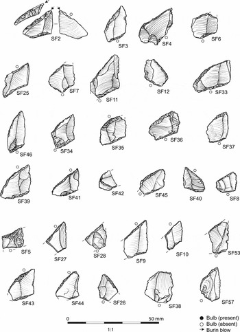
Overall, the scatter contained good evidence for flint knapping (e.g. cores, chips and pieces of irregular waste) and a variety of use activities. Retouched tools formed 5.5% of the total assemblage and included a broad range of artefact types, including scrapers of various forms, obliquely truncated flakes (some of which resemble the microliths but are less formally retouched) and piercing tools. Very few diagnostic Neolithic and Bronze Age lithics were present; a fact that again could suggest that much of the wider assemblage was Mesolithic in date. All of the microliths and the vast majority of the overall assemblage (95.7%) were manufactured from locally available beach-pebble flint; lithic raw materials are plentiful on the north coast of St Martin's around Great Bay and White Island, less than 2km from Old Quay (with good-quality, fist-sized flint pebbles and cobbles available).
Of the 57 microliths recovered, 48 are complete and classifiable, eight are small broken fragments that are unclassifiable and technologically uninformative, and one is complete but unclassifiable. The specific rhombic/trapezoidal form of the microliths from Old Quay cannot be paralleled in any other Mesolithic assemblage from Britain or Ireland. While rhomboid/bi-truncated (as they would be termed in Britain) points are occasionally found in British assemblages, these bear very little resemblance to those found either at Old Quay or on the continent. Trapezoidal (as they are termed on the continent) microliths of similar forms are, however, a common feature of Mesolithic lithic assemblages across continental Europe, from the Black Sea to France and Belgium. As discussed in further detail below, the closest parallels for those from Old Quay come from north of the River Seine in France, Belgium, the Netherlands and Denmark.
A detailed technical description of the microliths can be found in the Online Supplementary Material. This description demonstrates that the comparisons between them and continental European assemblages are considerably more than impressionistic. In summary, the key points are:
-
• The 48 identifiable microliths can generically be termed trapèze asymmétric (asymmetric trapezoids or rhomboids in English terminology).
-
• Forty-three can be classed more specifically as trapèze à base décalée (trapezoids with an offset base) (see Barrière et al. Reference Barrière, Daniel, Delporte, Escalon de Fonton, Parent, Roche, Rozoy, Tixier and Vignard1969 for definitions).
-
• Five can be classed more specifically as trapèze rectangle court (trapezoids with a ‘short rectangle’).
-
• The four previously illustrated microliths from Old Quay (Ratcliffe & Thorpe Reference Ratcliffe and Thorpe1991: 24; Dennis et al. Reference Dennis, Mulville and Johns2013: 16) are all classifiable as trapèze à base décalée.
-
• Nineteen of the microliths have additional retouch on the shortest side (petite base), executed in varying ways.
-
• They are predominately lateralised to the right rather than the left.
-
• They are predominately manufactured on flakes not blades.
-
• The assemblage shows very little evidence of the micro-burin technique.
Given that the microliths were recovered as a residual artefact scatter that was often mixed in with Neolithic material, it was not possible to obtain secure radiocarbon dates for them. The stratigraphic mixing of artefacts from different periods (see above) would have rendered any dating samples obtained from the buried soils insecure in terms of their chronological relationship to the microliths.
Typological parallels and differences
By far the closest parallels for those from Old Quay are found north of the River Seine in France, Belgium and the Netherlands (Thevenin Reference Thevenin1995; Emmanuel Ghesquière pers. comm.), over 550km from Scilly. Interestingly, the trapezoidal forms known from Brittany and Normandy—the closest regions of France to the Isles of Scilly (c. 200km distant)—do not include trapèze à base décalée and trapèze rectangle court forms comparable to those excavated at Old Quay (e.g. Cassen Reference Cassen1993; Marchand Reference Marchand, Whittle and Cummings2007). No use-wear analysis has yet been undertaken on the Old Quay assemblage, so it is not possible to compare them with the continental material in this way.
An in-depth discussion of the parallels between the Old Quay and continental forms can be found in the Online Supplementary Material. In summary, the key points are:
-
• Many sites in the Somme Basin, Belgium and the southern Netherlands have yielded microlith forms that can be paralleled at Old Quay (see Figure 7).
Despite these close similarities, subtle differences are discernible:
-
• Morphological differences in the angle of the petite base and the presence of straight truncations on the grande troncature on the Old Quay microliths exist in comparison to the continental material.
-
• Seven microliths from Old Quay have retouch on their ventral surfaces, but this is not invasive (retouch inverse plate) as it usually is on the continent (where it would be diagnostic of the Late–Final Mesolithic).
-
• The inverse retouch on the microliths at Old Quay is present on the petite base rather than the petite troncature, as is more common in the continental assemblages.
-
• The lateralisation of the Old Quay microliths to the left is very unusual in continental assemblages, only really being found within the Rhine-Meuse-Scheldt region; the Somme produces exclusively right-lateralised assemblages.
A selection of comparable microliths found in northern France; top: Le Mesnil-Saint-Firmin (Ducrocq Reference Ducrocq2001: fig. 28); bottom: Dreuil-les-Amiens (Ducrocq Reference Ducrocq2001: fig. 124).

In summary, the trapèze à base décalée microliths found at Old Quay can be paralleled with examples found in north-east France (north of the River Somme), Belgium and the Netherlands, during the Late and Final Mesolithic, c. seventh to fifth millennia BC. Given that the Old Quay microliths have a length–breadth ratio of <1, are produced on flakes rather than blades and lack flat ventral retouch, it is perhaps most likely that they date to the fifth rather than the seventh or sixth millennium BC (Philippe Crombé pers. comm.), although it is impossible to say for sure. Overall, it is important to point out that the continental comparators are not yet independently well-dated themselves (Crombé et al. Reference Crombé, Van Strydonck, Boudin, Crombé, Van Strydonck, Sergant, Boudin and Bats2009; Ducrocq Reference Ducrocq, Crombé, Van Strydonck, Sergant, Boudin and Bats2009). The precise origin of the Old Quay assemblage is difficult to establish as certain attributes (such as the use of flake blanks, the form of the petite base and style of retouch on the ventral surface) are subtly different to continental European assemblages, which themselves show significant inter-regional variability at this time (Robinson et al. Reference Robinson, Sergant and Crombé2013). The left lateralisation of the Old Quay microliths is, perhaps, a particularly important feature as it does not appear in French assemblages, but can be paralleled much farther east in the Rhine-Meuse-Scheldt region.
Old Quay microliths and maritime mobility
The presence of a large assemblage of microliths on the Isles of Scilly, whose closest typological affinities lie not in southern England but in northern France, Belgium and the Netherlands (Figure 8), is both puzzling and intriguing. As discussed, while the forms from Old Quay are not exactly the same as continental ones, importantly, they share many more similarities with them than they do with British microlith forms.
Map showing the Channel at 6000 BC; the dashed line indicates the approximate extent of the continental European distribution of microliths comparable to those found at Old Quay (note that their full distribution extends beyond the limits of this image—see main text for details). Map produced in part from Ordnance Survey Digimap, SeaZone solutions and GEBCO 08 (www.gebco.net<http://www.gebco.net/>) data. ©Crown Copyright/database right 2015. An Ordnance Survey/EDINA supplied service. ©Crown Copyright/SeaZone Solutions. All rights reserved. Licence no. 052006.001 31 July 2011. Not to be used for navigation. Additional data courtesy of the Channel Coastal Observatory.

It is, of course, theoretically possible that microliths typologically very similar to those produced on the near continent from the seventh to fifth millenna BC came to be manufactured on the Isles of Scilly independent of any social contact between the two regions. Given the apparent absence of permanent settlement on the islands at this time and generally low levels of Mesolithic activity there overall (Table 1), the people making the microliths at Old Quay are almost certain to have been visiting from somewhere else. If so, given the strong typological affinities with continental types, it seems to us most appropriate to see that place as being in continental Europe rather than southern England. If they were visiting from England, they were making a completely new form of microlith.
The fact, therefore, that the potential region of origin and the location of their discovery are at extreme opposite ends of the Channel is a crucial aspect of the evidence to account for in this case. Had the likely origin been Brittany or Normandy, or the Channel Islands, their recovery on the Isles of Scilly would have been easier to interpret—the result of a much shorter north--south sea journey (or journeys). The evidence as it stands is, however, most likely explained through one of three different scenarios: the first two view the material connections as essentially a consequence of a single, one-off journey; the third explores the possibility of more regularly maintained contact.
Scenario one suggests that a person or group of people living in Belgium or northern France travelled to the Isles of Scilly, establishing themselves there long enough to produce the potentially very large collection of microliths (and other Mesolithic flints) distributed across the site at Old Quay. If this period was fairly long, that duration could have resulted in ‘drift’ in the process of manufacture, leading to the few subtle differences observed between the assemblage found at Old Quay and those from the European mainland. It is also possible that this emigrating group chose to distinguish themselves intentionally from their founder community by making very similar-looking microliths in a subtly different way.
Scenario two places the dynamic of movement in the other direction. In this case, someone or a group living on the Isles of Scilly (or potentially even in south-west England or north-west France) could have travelled to Belgium or northern France, lived there for long enough to pick up the local manufacturing style and then returned (directly or indirectly) to Scilly. If this was the case, that person or group would have been very well travelled, but that is perfectly possible.
Scenario three suggests that people in (or visiting) Scilly and people in Belgium or northern France may have been in fairly regular contact in the medium to long term. As a result, the style of microlith manufacture in both regions stayed similar (if not exactly the same) over the duration of that period. The initial process(es) lying behind these long-term cross-Channel links may have been close to scenario one or two.
Any journey between northern France and Scilly certainly could have been undertaken in a single voyage; Callaghan & Scarre (Reference Callaghan and Scarre2009), for example, have explored the possibilities of direct sea travel such as this in their models. It is also feasible that this single trip was never intended, with the weather and tides intervening to sweep a boat off course and the lucky mariners ending up on a small group of islands west of Cornwall, rather than meeting their collective end out in the Atlantic Ocean. Equally, it is possible that such journeys were made in a series of shorter steps along the south coast of England, or even along the northern coast of France and then straight over from Brittany or Normandy. It is ultimately impossible to know.
Logically—as has been the case with other key material glimpses of contact (the Ferriter's Cove cow bones or the jadeitite axes) discussed above—it is not possible to distinguish between the three scenarios. Material connections can be identified, but who was responsible for them, how often they occurred or the exact route they took is essentially impossible to determine. Our feeling is that scenario three is perhaps the most likely, especially since it could potentially incorporate the possibility of scenario one or two as well. As Warren (Reference Warren, Anderson-Whymark, Garrow and Sturt2015) has argued in detail, in order for hunter-gatherers to maintain a viable population even on islands much larger than Scilly, a considerable degree of maritime interaction with those living elsewhere would have been necessary. The very low level of Mesolithic activity so far identified elsewhere in Scilly makes it hard to estimate the kind of occupation witnessed on the islands at this time. While the material found at Old Quay in 2013 has created a new scale of Mesolithic site on the islands, the material recovered there could nevertheless still have been created through multiple seasonal visits over a relatively long period of time—our preferred interpretation. Equally, other comparably large sites may still await discovery elsewhere on the islands.
It is important to note at the end of this discussion that the appearance of trapeze microlith forms across much of continental Europe is seen by some as a very significant part of a broader suite of technological shifts that coincided with wider social change during the seventh millennium BC (Perrin et al. Reference Perrin, Marchand, Allard, Binder, Collina, Garcia-Puchol and Valdeyron2009; Warren Reference Warren, Anderson-Whymark, Garrow and Sturt2015). The fact that similar technological changes are seen to have occurred across large parts of Europe has led some to suggest that long-distance connections may well have been much more prevalent and pervasive than we might perhaps expect (Costa & Marchand Reference Costa and Marchand2006; Warren Reference Warren, Anderson-Whymark, Garrow and Sturt2015).
Conclusion
Certain aspects of the story of the microliths from Old Quay resonate with elements of the cross-Channel narrative that has been told for the fourth millennium BC. The absence of any clearly definable directionality to the material connections, and the difficulty of establishing a precise source region for the artefacts found, are echoed in later evidence, such as the Ferriter's Cove cow bones (which could have been brought to south-west Ireland or fetched from western France), and the Earliest Neolithic ceramic assemblages in southern England (in which certain similarities to, but also key missing elements from, continental assemblages can be observed). The process of transition was not straightforward, clear or simple, but rather ‘messy’, with multiple origins and complex connections that occurred in different directions (Anderson-Whymark & Garrow Reference Anderson-Whymark, Garrow, Anderson-Whymark, Garrow and Sturt2015).
At the same time, the assemblage from Old Quay is also surprising and unique—especially in terms of the extent and direction of the geographic connections it suggests. It is important that the archaeological record surprises us sometimes, challenging our assumptions. The fact that the maritime connections we are talking about here potentially extend the entire length of the Channel forces us to rethink our expectations as to the character and extent of sea travel at that time. It also reminds us to think critically about the nature of that travel. It seems most likely that, in this case, we are not talking about a single sea journey, but rather journey(s) made in multiple steps along either the southern English or northern French coast.
In trying to understand maritime connections with the continent once Britain had become an island, it is necessary to identify, and then to make the most of, the very occasional material glimpses of contact that we find. The microliths recovered at Old Quay represent a very important glimpse that adds significantly to our appreciation of maritime mobility during the seventh to fifth millennium BC.
Since this paper was first submitted, a further season of excavation has been carried out at Old Quay (September 2014). During this work, substantial additional evidence of Neolithic settlement was recovered. Twenty-three directly comparable microliths were found, augmenting the assemblage described within this paper; again, these were not in situ. The results of this work will be published in due course (Garrow & Sturt in prep.).
Acknowledgements
We would like to thank: the Arts & Humanities Research Council (AHRC) who funded the 2013 excavations at Old Quay as part of the broader ‘Stepping Stones to the Neolithic project’ (AH/I021841/1); the people of St Martin's for making us feel so welcome and for showing so much interest in what we found; Steve Walder and Chris Gregory (Duchy of Cornwall) for permission to work on the site; Phil McMahon (English Heritage), Lone Mouritsen and Jules Webber (Natural England) for their broader assistance in enabling us to carry out our work there; Charlie Johns for suggesting that we dig at Old Quay in the first place, for sharing his specialist archaeological and logistical knowledge of the islands, and for assisting us in many other ways; Ian Dennis and Jacqui Mulville for discussions about their previous work at the site; Amanda Martin for her help both generally and specifically in providing access to the Isle of Scilly Museum's collections; Trevor Kirk for his support and advice; Henrietta Quinnell for sharing her knowledge of south-western prehistoric pottery; the excavation team who dug the site, enabling us to find out so much in only four weeks (Kate Boulden, Will Budd, Nicky David, Ian Dennis, Rose Ferraby, Caroline Godwin, Dave Godwin, Charlie Johns, Jonathan Last, John Lihou, Anna Peacock, Roderigo Pancheco-Ruiz, Penny Rogers, Robert Smith, Dan Stansbie, Toby Tobin-Duggan, Linda Wornes); Sarah Lambert-Gates for her excellent microlith illustrations; Thierry Ducrocq for permission to reproduce the images in Figure 7; Chantal Conneller, Philippe Crombé, Emmanuel Ghesquière, Grégor Marchand, Cyril Marcigny, Erick Robinson and Chris Scarre for their advice on the continental European material; and finally Chantal Conneller, Anwen Cooper, Philippe Crombé, Charlie Johns, Erick Robinson, Graeme Warren and one anonymous reviewer for their very helpful comments on earlier drafts of this paper.
Supplementary material
To view supplementary material for this article, please visit http://dx.doi.org/10.15184/aqy.2015.77


 Open access