


Nomenclature
- ATM
-
Air Traffic Management
- ATC
-
Air Traffic Control
- CB
-
Cumulonimbus
- CAT
-
Clear Air Turbulence
- ERA5
-
ECMWF Reanalysis v5
- ECMWF
-
European Centre for Medium-Range Weather Forecasts
- FMS
-
Flight Management System
- BADA
-
Base of Aircraft Data
- ADS-B
-
Automatic Dependent Surveillance–Broadcast
- Mode-S
-
Mode Select Surveillance
- ML
-
Machine Learning
- RL
-
Reinforcement Learning
- GA
-
Genetic Algorithm
1.0 Introduction
Weather analysis plays a crucial role in the aviation industry, as it directly impacts flight planning, fuel consumption and overall operational efficiency. By integrating meteorological information into flight route optimisation strategies, airlines can minimise delays, reduce fuel costs and enhance the overall travel experience for passengers.
Furthermore, with advances in technology and data analytics, the accuracy of weather forecasting has improved significantly. For instance, the average error in 72-hour hurricane forecasts has decreased from over 400 nautical miles in the 1970s to less than 80 miles in recent years [1]. As a result, the enhanced reliability of weather forecasts has empowered airlines and air traffic controllers to make dynamic, real-time routing decisions that better adapt to evolving atmospheric conditions.
Population growth and industrialisation have significantly contributed to atmospheric degradation, including increased greenhouse gas emissions and pollution. These changes have intensified the effects of climate change, which pose growing challenges to the aviation industry, such as increased turbulence, more frequent weather-related delays, and operational uncertainty. With climate change, meteorological parameters – such as wind shear, convective storms, icing conditions and sudden pressure fluctuations – have become increasingly volatile and impact flight operations [Reference Burbidge2]. Extreme weather events occur more frequently worldwide, including thunderstorms, turbulence and low visibility due to fog or heavy precipitation. The severity of these conditions has been linked to several aviation accidents; for example, the 2009 Air France Flight 447 crash was partially attributed to weather-related factors. Therefore, accurately reading, interpreting, and managing meteorological inputs from forecast models and real-time observations is vital for ensuring flight safety and operational efficiency.
Effective flight operations require integrating meteorological considerations at all stages of flight. Pre-flight planning must account for forecasted weather conditions to avoid hazardous zones; in-flight decisions should adapt dynamically to real-time meteorological inputs; and post-flight assessments should evaluate encountered weather for operational learning. Accurately interpreting this data is fundamental to assess hazards that may not be eliminated or controlled and to determine their potential impact on safety. Mitigating or minimising these risks through adaptive routing and informed decision-making is a cornerstone of modern flight safety management.
Efficient air traffic management requires precise planning of flight trajectories and airport operations [Reference Meijer3]. Deviations in flight paths can trigger cascading effects, disrupting sequencing, spacing and slot allocations for other aircraft, ultimately resulting in operational inefficiencies and increased costs [Reference Maatouk4]. The inherent uncertainties in meteorological forecasts further complicate this process by introducing dynamic variables that are difficult to predict and mitigate in real-time [Reference Jung and Clarke5]. To address these challenges, modern air traffic systems – including flight management systems (FMS) – use both weather forecast data and wind measurements obtained from onboard sensors to optimise flight trajectories and anticipate potential disruptions [Reference Dancila and Botez6]. Integrated enhanced meteorological forecasts into trajectory optimisation models, underlining their contribution to flight predictability. As demonstrated inRef. (Reference Bronsvoort, McDonald, Potts and Gutt7), the tailored descent wind method provides customised wind fields based on the selected landing procedure, using fine-scale regional forecasts. This enables FMS to compute continuous descent operations (CDO) with greater accuracy and robustness. Nonetheless, weather impacts on aviation are not limited to forecast uncertainties in wind fields; a wide spectrum of hazardous phenomena also plays a decisive role in operational efficiency and safety. Microbursts, convective storms, icing, wind shear, turbulence, low visibility and cumulonimbus (CB) cloud formations have been directly linked to delays, rerouting, and, in some cases, safety-critical incidents [Reference Burbidge2, 8].
Meteorological variables contributing to adverse weather must be carefully monitored and analysed to mitigate the operational impacts of such phenomena. Parameters, including wind speed and direction, temperature, dew point, cloud density and atmospheric pressure, play a vital role in flight trajectory optimisation. Although these variables are factored into flight planning, the dynamic nature of the atmosphere often leads to deviations between the planned and actual flight paths. These discrepancies can increase fuel consumption, delays, airspace congestion and broader technical and commercial consequences.
This review article synthesises recent advancements in flight route optimisation and planning methodologies that incorporate meteorological data. While particular attention is given to the challenges posed by adverse weather conditions – such as turbulence, thunderstorms, wind shear and low visibility – the review also encompasses studies that address general meteorological variables such as wind, temperature, pressure and humidity, within both strategic and tactical flight planning contexts. A summary of different research efforts, practical implementations, algorithmic techniques and forecast objectives is provided to present the current state of knowledge on this topic. This research aims to identify key meteorological variables and optimisation strategies that help researchers and practitioners develop robust routing frameworks in aviation. We conducted a systematic literature review using databases such as Scopus, Web of Science, Semantic Scholar and Google Scholar, covering peer-reviewed publications from December 2001 to March 2024. From this, 57 studies were selected for detailed analysis. Our analysis indicates that the majority of the reviewed studies emphasise the integration of real-time meteorological data – especially convective weather, wind and turbulence – into route optimisation frameworks. These studies consistently report improved fuel efficiency, reduced delays, and enhanced operational safety when such parameters are accounted for in the planning process.
This paper is organised as follows. Section 2 introduces meteorological-based route planning and optimisation. Section 3 presents our proposed approach to our review method. Section 4 discusses the survey results, including the integration of meteorological data, practical algorithms and methodologies, the impact of meteorological conditions, trade-offs in optimisation objectives, practical applications and projected objectives. Finally, Section 5 concludes the article with a summary of the findings and suggestions for future research directions.
2.0 Route planning and optimisation problem based on meteorological conditions
This section provides the technical and conceptual background necessary to understand the scope and significance of flight route optimisation in meteorological conditions. It introduces fundamental concepts such as trajectory planning, strategic vs. tactical decision-making, and the influence of weather on flight operations. This section establishes the analytical foundation upon which the surveyed literature builds by clarifying how optimisation problems are formulated and solved using various techniques – including traditional and machine learning-based methods. The definitions and categorisations presented here support the structure of the literature review in Section 3 and guide the thematic synthesis of findings throughout the article.
Route planning and optimisation in aviation involve selecting the most efficient and safe flight trajectory while considering fuel consumption, flight time, aircraft performance, meteorological hazards and regulatory constraints. The process is inherently complex due to the dynamic and uncertain nature of atmospheric conditions, requiring both forecast-based planning and real-time decision-making. It is therefore essential to distinguish between strategic (pre-flight) planning – based on forecasted weather and airspace structure – and tactical (in-flight) planning, which accounts for updated meteorological observations and operational constraints.
Trajectory optimisation typically begins with defining the origin and destination, available company-preferred routes and forecasted weather conditions (e.g. thunderstorms, turbulence, icing). These predefined routes are evaluated for feasibility, and if adverse weather is unavoidable, dynamic re-routing is conducted using trajectory optimisation models and meteorological inputs. This adaptive framework enables the minimisation of delays and fuel usage while maintaining safety and compliance with air traffic control (ATC) regulations.
Flight route planning is a multi-stage process designed to minimise operational costs while ensuring safety under dynamic atmospheric conditions. Modern air traffic management distinguishes between strategic (pre-flight) and tactical (in-flight) planning, which differ in their time horizons, data inputs and decision-making methods [9, 10].
The route optimisation problem relies on three main input categories: meteorological forecasts (e.g. ECMWF Reanalysis v5 (ERA5) and World Area Forecast System (WAFS) products, which provide wind, temperature, turbulence, and convective airspace), aircraft performance models (such as Base of Aircraft Data (BADA) or manufacturer-specific fuel flow tables) and air traffic restrictions (including restricted areas and ATC flow regulations). Commonly used datasets in aviation are detailed in Section 4. Flight planning is typically divided into two phases: strategic planning, performed several hours before takeoff using forecast data and predefined routes, and tactical planning, performed in flight with near-real-time updates from onboard radar, ADS-B, and uplink forecasts to enable dynamic rerouting. This layered structure ensures that the optimisation remains feasible despite forecast uncertainties and changing atmospheric conditions.
To formally describe the route optimisation problem under meteorological constraints, we define the total cost functional $J$
, which quantifies the cumulative operational cost of a given flight trajectory
$J$
, which quantifies the cumulative operational cost of a given flight trajectory $x\left( t \right)$
over the flight time interval
$x\left( t \right)$
over the flight time interval $\left[ {{t_0},{t_f}} \right)$
:
$\left[ {{t_0},{t_f}} \right)$
:
 \begin{align*}J = \int _{{t_0}}^{{t_f}}\,[{C_{\rm{fuel}}}(x(t),u(t)) + {C_{\rm{time}}}(x(t),u(t)) + {C_{\rm{weather}}}(x(t),u(t),w(t))]dt,\end{align*}
where:
-
• $x\left( t \right)$
: the state vector (e.g. position, velocity)
$x\left( t \right)$
: the state vector (e.g. position, velocity) -
•
$u\left( t \right)$
: the control input vector (e.g. heading, throttle, climb rate) -
•
$\left( t \right)$
: the meteorological field (e.g. wind, turbulence, CB clouds) -
•
${C_{{\rm{fuel}}}}$
: fuel consumption cost -
•
${C_{{\rm{time}}}}$
: time-dependent cost -
•
${C_{{\rm{weather}}}}$
: weather penalty function


The optimisation is subject to:
 \begin{align*}\dot x\left( t \right) = f\left( {x\left( t \right),u\left( t \right),w\left( t \right)} \right){\rm{\;\;\;\;}}\left( {{\rm{aircraftdynamics}}} \right),\end{align*}
and additional constraints including aircraft performance limitations, airspace regulations and meteorological hazards.
This formulation is widely used in trajectory optimisation frameworks. Figure 1 presents the general framework, illustrating how meteorological data and operational constraints are integrated into the weather avoidance optimisation process and how the strategic and tactical planning phases interact to maintain safety and efficiency.
Hierarchical representation of operational aspects for weather avoidance in aviation. The pyramid distinguishes between strategic (pre-flight) and tactical (in-flight) measures.

The challenges in flight route planning are typically formulated as multi-objective optimisation problems, aiming to minimise parameters such as flight time, fuel consumption and environmental impact while adhering to safety constraints and regulatory requirements. With the integration of meteorological factors – especially stochastic variables like wind fields, turbulence and convective weather – these problems become inherently nonlinear and time-dependent. As a result, optimisation algorithms must be both robust and adaptive. Recent studies have employed metaheuristic approaches, such as genetic algorithms (GA) and ant colony optimisation (ACO), to incorporate weather-aware multi-objective route optimisation scenarios [Reference Alam, Lokan, Oliveira and Trani11]. In addition, reinforcement learning (RL)-based strategies are emerging in air traffic management as effective tools for real-time adaptive routing under meteorological uncertainties [Reference Kravaris, Spatharis, Bastas and Gkiokas12, Reference Zhang, Li and Zhao13].
Weather-related factors, such as wind patterns, convective weather, turbulence and temperature variations, can significantly affect flight trajectories. For example, strong headwinds can increase fuel consumption, while turbulence can affect flight stability and passenger comfort. In addition, extreme weather events, such as thunderstorms or hurricanes, can require significant deviations from planned routes, further complicating air traffic management. Hence, optimising flight paths based on meteorological data involves balancing these factors to find the most efficient and safe route under weather conditions.
Advances in optimisation techniques, particularly the integration of machine learning (ML) algorithms, have introduced new strategies for solving complex, weather-dependent route planning problems. Unlike traditional algorithms – which often rely on static rule-based systems or deterministic models – ML approaches can process large-scale historical weather and flight performance datasets to identify patterns and make probabilistic predictions. For example, supervised learning models have been used to forecast convective weather zones and estimate their future movement, allowing for proactive route adjustments. By learning from environmental feedback, reinforcement learning algorithms have also demonstrated the ability to optimise real-time trajectory decisions under uncertainty. In contrast, while effective for structured optimisation, conventional methods such as dynamic programming and genetic algorithms often struggle with scalability and adaptability in highly dynamic, data-intensive environments.
3.0 Research method
3.1 Research questions
This section outlines the research methodology used to conduct a comprehensive survey of the literature on route optimisation and planning based on meteorological data. The review adopts a systematic approach to identify and analyse relevant studies published in the past two decades. The methodology involves formulating key research questions, developing a search strategy, and applying inclusion and exclusion criteria to select primary studies.
The four research questions guiding this review were formulated based on recurring themes, challenges, and knowledge gaps identified in the literature. Existing studies often explore route optimisation under fixed or limited meteorological scenarios, lack integration of real-time weather data, or focus on isolated objectives such as fuel efficiency without addressing safety trade-offs. Therefore, the research questions aim to synthesise fragmented findings, highlight underexplored areas, and provide a structured basis for evaluating the current state-of-the-art and future research opportunities.
-
• Q1. How can meteorological data be integrated into route optimisation algorithms to enhance flight efficiency and safety?
-
• Q2. What are the most effective algorithms and methodologies for route optimisation considering meteorological data?
-
• Q3. How do different meteorological conditions impact flight route planning and optimisation?
-
• Q4. What are the trade-offs between optimisation objectives, such as fuel consumption, flight time and safety?
These questions aim to address the central challenges of optimising flight paths in dynamic atmospheric conditions, providing a foundation for analysing existing methodologies and proposing future research directions.
3.2 Searching and selection primary studies
A systematic search was conducted using multiple academic databases, including ScienceDirect, IEEE Xplore, SpringerLink, Web of Science, Scopus and Google Scholar. The search covered peer-reviewed journal articles and conference papers published between December 2001 and March 2024.
The following Boolean search query was used (with minor adaptations depending on database syntax):
(“route optimisation” OR “flight planning”) AND (“meteorological data” OR “weather information”) AND (“air traffic” OR “trajectory” OR “flight path”)
Searches were conducted in English only, and duplicates across databases were removed. Articles were screened in three stages:
-
1. Title and abstract screening: Papers clearly unrelated to aviation or meteorology were excluded.
-
2. Full-text eligibility: Papers that mentioned meteorological influence but did not include it in optimisation or planning processes were excluded.
-
3. Final selection: Studies were included if they proposed, evaluated or applied an optimisation or planning model incorporating meteorological variables.
In total, 184 papers were initially identified. After removing duplicates and irrelevant entries, 57 studies were selected as primary sources for full review and synthesis.
This process ensured the transparency and reproducibility of the literature review.
3.2.1 Search strategy
As introduced in Section 3.2, a structured search strategy was employed to ensure reproducibility. This subsection details the selection and use of keywords during the search.
We categorised keywords into two groups:
-
• Primary Keywords: Core terms essential to the study scope, such as ‘route optimisation’, ‘flight planning’, ‘meteorological data’, ‘air traffic management’ and ‘trajectory optimisation’.
-
• Secondary Keywords: Complementary terms that enhance coverage of relevant techniques and subtopics, such as ‘weather forecasting in aviation’, ‘machine learning in flight optimisation’ and ‘meteorological integration in air traffic control’.
The following Boolean query was used to combine these terms:
(“route optimisation” OR “flight planning”) AND (“meteorological data” OR “weather”) AND (“air traffic” OR “trajectory”)
This query was adapted to fit the syntax of each academic database. The keyword classification helped to prioritise core topics while expanding the scope through related terms.
3.2.2 Inclusion and exclusion criteria
A rigorous set of inclusion and exclusion criteria was applied during the screening process to ensure the relevance and quality of the studies included in this review. These criteria guided the title/abstract screening and the full-text evaluation phases.
Inclusion criteria:
-
• Studies that explicitly focus on flight route optimisation or planning.
-
• Studies that incorporate meteorological data into the optimisation or decision-making process (e.g. wind, convective weather, turbulence).
-
• Peer-reviewed journal articles, conference papers, or substantial technical reports published by recognised academic publishers.
-
• Publications dated between December 2001 and March 2024 to ensure contemporary methodological and technological relevance.
Exclusion criteria:
-
• Studies that do not pertain to aviation or address route optimisation in other transportation domains (e.g. maritime or urban mobility).
-
• Studies that mention meteorological terms do not integrate weather data into the route planning or optimisation framework.
-
• Non-peer-reviewed materials include editorials, blog posts, opinion pieces, or student theses.
-
• Studies published in languages other than English due to resource limitations for translation and consistent interpretation.
These criteria were applied manually by reviewing the titles, abstracts and full texts where necessary. The aim was to ensure that only methodologically rigorous and thematically relevant studies were included in the final analysis.
3.2.3 Selection process
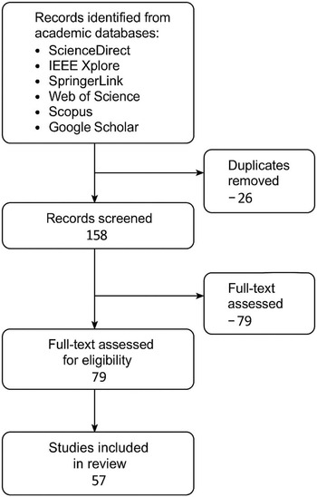
The selection process was conducted in three main stages:
-
1. Initial Search and Screening: The database search returned 184 records. After removing 26 duplicates, 158 unique studies remained. These were screened based on title and abstract. At this stage, 79 papers were excluded because they were clearly unrelated to aviation or route optimisation.
-
2. Full-Text Review: The remaining 79 studies were reviewed in full. After applying the inclusion and exclusion criteria, 22 additional studies were excluded, primarily due to insufficient methodological detail, lack of meteorological data integration, or non-peer review.
-
3. Data Extraction: A final set of 57 studies was selected for detailed analysis. Relevant data from each study – such as reference number, task/objective, methods used and meteorological data involved – were extracted and organised in a summary table (see Table 4; 6; 8; 10; 12).
This multi-step selection procedure is illustrated in Fig. 2, which shows the number of records identified, screened, excluded and included at each stage of the review process.
Flow diagram of the article selection process.

This structured multi-step process ensured that the final corpus represents a robust and thematically relevant set of studies for analysing the integration of meteorological data into flight route optimisation and planning.
4.0 Synthesis of research on route optimisation based on meteorological conditions
This section synthesises the findings of 57 selected studies on route optimisation and planning under meteorological conditions. The analysis is organised into six thematic categories: (1) classical rule-based optimisation methods – where ‘classical’ refers to non-AI, deterministic, or heuristic approaches such as dynamic programming, Dijkstra-based shortest path algorithms and predefined operational rules, which rely on fixed constraints and do not adapt through data-driven learning; (2) data-driven and AI-based approaches; (3) hybrid and integrated frameworks; (4) trade-offs and operational considerations; (5) practical implementations in real-world systems; and (6) research gaps and future directions.
Each subsection summarises the relevant literature, highlights the type and source of meteorological data used (e.g. forecast, measured, simulated), discusses methodological choices regarding flight planning stages and evaluates the advantages and limitations of various optimisation strategies. The corresponding tables provide a structured overview of the reviewed studies’ objectives, techniques and atmospheric variables. These are complemented by dataset usage statistics and visualisations that quantify the prevalence of each data source in the literature, enabling a clear comparison of methodological trends and meteorological parameter integration.
Understanding the prevalence and characteristics of meteorological datasets is vital for interpreting the methodological choices observed in the reviewed studies. The frequency with which certain atmospheric parameters (e.g. wind speed/direction, convective weather indicators) are employed directly influences the optimisation approach, from cost function design to constraint formulation. In this context, the subsequent analysis quantifies dataset usage across the literature, highlighting which data sources and parameters are most frequently integrated into route optimisation workflows.
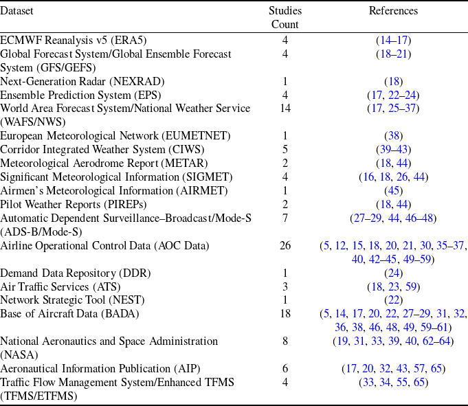
To better understand the role of meteorological datasets in trajectory optimisation, Table 1 summarises the most commonly used data sources in the reviewed studies. For each dataset, the table specifies the provider, main meteorological or operational parameters, temporal and spatial resolution and its typical use in optimisation workflows. This structured overview facilitates a clearer comparison of the capabilities and limitations of different datasets, enabling researchers to select appropriate sources for specific optimisation objectives.
In addition to describing the datasets themselves, quantifying their prevalence in the reviewed literature provides deeper insight into current research practices. Table 2 summarises the number of studies in which each dataset type has been employed, together with the corresponding references. This synthesis not only identifies the most frequently adopted data sources but also highlights underutilised datasets that may offer valuable opportunities for future research in trajectory optimisation under meteorological constraints.
Commonly used datasets in aviation trajectory optimisation and their characteristics

Meteorological datasets – particularly global forecasting products such as WAFS and National Weather Service (NWS) – constitute the largest share (≈45% of all cases), reflecting their high temporal coverage, global spatial resolution and operational reliability. These datasets are widely adopted because they provide standardised, continuously updated weather parameters indispensable for trajectory optimisation, including wind fields, temperature profiles and convective weather indices. Operational datasets, such as flight plans and air traffic flow management (ATFM) data from European Organisation for the Safety of Air Navigation (EUROCONTROL) and International Civil Aviation Organization (ICAO) sources, account for ≈30% of usage. Their popularity stems from their ability to capture real-world constraints, such as sector capacities, airspace restrictions and preferred routings, enabling more realistic and implementable optimisation outcomes. Performance datasets (≈15%), often derived from aircraft manufacturer data or models like BADA, are crucial for accurate fuel burn and climb/descent profile estimation. Navigation datasets (≈10%), while less frequently used, provide fundamental route structure and waypoint information that can significantly affect optimisation when combined with meteorological and performance parameters. This distribution highlights not only the dominance of certain well-established datasets but also the potential research opportunities in underutilised sources – such as high-resolution local weather observations or advanced turbulence detection products – that may offer improved trajectory efficiency under challenging atmospheric conditions.
Dataset usage in reviewed trajectory optimisation studies

4.1 Classical and rule-based optimisation methods
Table 3 summarises the studies that utilise classical optimisation techniques, such as graph-based algorithms (e.g. A*, Dijkstra), control theory methods, and deterministic models, to optimise flight routes under meteorological constraints.
Classical and rule-based optimisation methods and graph-based pathfinding algorithms are frequently employed in pre-flight planning due to their computational efficiency and deterministic behaviour. These methods are instrumental when operating under relatively stable meteorological conditions or in systems requiring rapid, repeatable solutions with limited uncertainty handling. For example [Reference Kim and Mavris44, Reference Gonzalo, Domnguez and López66], applied graph-based algorithms to minimise en-route phase duration or path length, relying primarily on wind and convection forecasts.
Classical methods such as Dijkstra and A* are inherently deterministic and are most commonly applied with static or forecast-based meteorological inputs. This limits their adaptability in rapidly changing weather conditions. Nevertheless, several studies have extended these algorithms to incorporate uncertainty through stochastic cost functions, probabilistic weather fields or scenario-based graph structures. Such extensions demonstrate that while the baseline formulation does not inherently capture probabilistic predictions, the methods can indeed be adapted to address uncertainty. Despite these advances, their deterministic use remains far more common in operational practice due to its computational simplicity and transparency.
These approaches are best suited for strategic planning phases – where weather data can be integrated from forecast models with lower temporal resolution – and less applicable to tactical, in-flight decision-making. Nevertheless, their simplicity, speed and low computational load make them strong baseline solutions or complementary components within hybrid frameworks.
In addition to their methodological characteristics, these approaches demonstrate a specific pattern in how meteorological data is integrated into the optimisation process.
The classical optimisation methods reviewed in this section primarily rely on forecasted meteorological parameters – especially wind and convection data – to construct feasible and efficient routes. Usually, these weather inputs are incorporated as static or semi-dynamic fields into cost functions or graph weights. For instance, wind vectors are used to calculate ground speed and fuel cost in graph-based models like A* or Dijkstra, while areas with convective activity are treated as high-penalty or no-fly zones. Although effective for route planning under predictable conditions, these approaches often lack adaptability to real-time weather changes and probabilistic uncertainty, limiting their use in highly dynamic environments.
4.2 Data-driven and AI-based optimisation methods
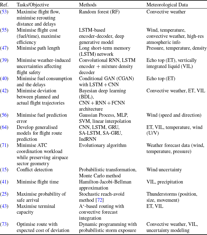
Table 4 summarises the studies that leverage ML, deep learning (DL) and other data-driven approaches to enhance route optimisation under dynamic meteorological conditions.
Data-driven and AI-based approaches have gained substantial traction in recent years due to their ability to learn complex patterns from large-scale historical and real-time data. These methods are particularly suited for scenarios where meteorological variables exhibit nonlinear, time-dependent, and uncertain behaviour – conditions under which classical methods struggle. For instance, deep learning models such as long short-term memory (LSTM) and convolutional neural networks (CNN) have been effectively used to capture temporal and spatial patterns in convective weather and turbulence, enhancing the ability to forecast hazardous regions and adapt flight trajectories accordingly [Reference Pang, Yao, Hu and Liu39, Reference Pang and Liu40, Reference Liu and Hansen55].
Yuan et al. [Reference Yuan, Pei, Xu, Ge and Wei46] employed a Multi-Agent Reinforcement Learning (MARL) framework to manage spacing among multiple aircraft while minimising fuel consumption autonomously. Although weather uncertainty was not explicitly modeled, their approach demonstrates the potential of MARL in handling complex decision-making tasks in multi-aircraft operations, which could be extended to include meteorological variability.
Summary of classical and rule-based optimisation studies; summary of data-driven and AI-based optimisation studies

Pang et al. [Reference Pang, Zhao, Hu and Liu52] developed a machine learning-enhanced aircraft landing scheduling approach that accounts for operational uncertainties, including those caused by weather disruptions. Their work highlights the feasibility of integrating data-driven techniques into arrival management systems, offering more resilient and adaptive scheduling under uncertain conditions.
Summary of data-driven and AI-based optimisation studies

Training models often achieve the integration of meteorological data in AI-based frameworks on features such as wind speed and direction, temperature gradients, convective indices (e.g. Echo Top (ET), Vertically Integrated Liquid (VIL)) and high-resolution atmospheric fields. These parameters can be used as direct model inputs or as part of a preprocessing step to generate weather impact metrics. For example, random forest and supervised learning algorithms have been employed to classify weather severity or predict delay probabilities based on input features derived from meteorological data [Reference Wang, Duan, Chu, Li and Yang53, Reference Kim, Zhang, Briceno and Mavris56].
A key advantage of these approaches lies in their adaptability and predictive power – especially in real-time applications. However, their performance is highly dependent on the availability and quality of training data, and they may suffer from generalisation issues when deployed in regions or timeframes not well represented in the dataset. Furthermore, the interpretability of complex AI models remains a concern in safety-critical domains such as aviation.
AI-based methods offer promising enhancements to weather-aware route optimisation, particularly in tactical and short-term planning phases. They are most effective when real-time or probabilistic weather inputs enable dynamic decision-making in volatile atmospheric environments.
Figure 3 presents an integrated framework that combines meteorological data sources (e.g. ECMWF Reanalysis v5 (ERA5), Meteorological Aerodrome Report (METAR), Terminal Aerodrome Forecast (TAF), and aviation advisories such as Significant Meteorological Information (SIGMET) and Airmen’s Meteorological Information (AIRMET)) with key atmospheric parameters including wind, temperature, pressure, jet streams and convective indices. These inputs are processed through AI-based optimisation models – ranging from time-dependent A* and deep learning architectures (e.g. LSTM) to Reinforcement Learning (RL/MARL) and supervised learning approaches such as random forest for delay prediction. In parallel, operational considerations, including airspace restrictions, aircraft performance limits and safety criteria, are embedded into the decision-making process. The integration of meteorological variability with operational constraints enables the generation of optimised routes that minimise fuel consumption, reduce flight time and enhance safety through proactive risk avoidance.
4.3 Hybrid and integrated frameworks
Table 5 summarises selected studies that implement hybrid optimisation frameworks, combining multiple algorithmic approaches – such as deterministic models with machine learning – or integrating meteorological data across multiple stages of the flight planning process.
Summary of hybrid and integrated optimisation studies

Integration of meteorological data into AI-based route optimisation frameworks.

Hybrid and integrated frameworks represent a growing trend in route optimisation research, where multiple algorithmic strategies are combined to address the inherent complexity and uncertainty of meteorologically influenced flight planning. These approaches often merge traditional pathfinding algorithms with data-driven or probabilistic models to leverage interpretability and adaptability. For instance, several studies combine deterministic methods like A* with machine learning or probabilistic control to enhance real-time responsiveness while retaining trajectory stability under uncertainty [Reference González-Arribas, Baneshi, Andrés, Soler, Jardines and Garca-Heras17, Reference Kim, Justin, Mavris and Briceno18, Reference Kim, Briceno, Justin and Mavris58].
Barea et al. [Reference Barea, de Celis and Cadarso51] proposed an integrated framework that optimises runway assignments and aircraft trajectories, demonstrating how coupling airport-level decisions with en-route optimisation can enhance operational efficiency and airspace utilisation. While meteorological uncertainty was not the primary focus, the framework could be extended to incorporate weather-aware constraints.
Hybrid and integrated optimisation structures used in meteorologically informed flight route planning.

A notable contribution of these frameworks lies in their capacity to process multi-source meteorological inputs across different planning layers – strategic (pre-flight), tactical (in-flight) and predictive (nowcasting). Some studies incorporate probabilistic nowcasting of convective weather to adjust routes under uncertain storm development scenarios dynamically [Reference González-Arribas, Soler, Sanjurjo-Rivo, Kamgarpour and Simarro74]. Others integrate Bayesian inference or deep hybrid architectures (e.g. CNN + RNN + FCNN) to capture spatiotemporal weather patterns and refine trajectory predictions [Reference Pang, Zhao, Yan and Liu42, Reference Schimpf, Wang, Li, Knoblock, Li and Apaza64].
The flexibility of hybrid models enables the integration of diverse meteorological parameters – such as Echo Top (ET), (VIL, Significant Meteorological Information (SIGMET) and pressure-level wind data – not just as static constraints but as dynamic elements driving decision-making. Despite their potential, these frameworks often require high computational resources and reliable real-time data streams, which may limit their deployment in specific operational contexts. Nonetheless, they represent a promising direction for developing robust and scalable route optimisation systems in aviation, particularly under volatile weather conditions.
As illustrated in Fig. 4, hybrid optimisation frameworks often combine classical pathfinding with probabilistic or machine learning-based modules to support weather-aware flight planning.
4.4 Trade-offs and multi-objective optimisation
Table 6 summarises selected studies that address route optimisation as a multi-objective problem, aiming to balance trade-offs between operational efficiency, fuel consumption, safety, environmental impact and predictability.
Summary of multi-objective optimisation studies

In addition to optimising flight time and fuel usage, recent studies have incorporated climate-related externalities into the objective functions. For example, Rosenow et al. [Reference Rosenow, Lindner and Fricke49] proposed a parametric model that integrates climate cost factors – such as ${\rm{C}}{{\rm{O}}_2}$
emissions and contrail impact – into network-level trajectory optimisation. Their results emphasise the growing need for environmental effects in strategic route planning.
${\rm{C}}{{\rm{O}}_2}$
emissions and contrail impact – into network-level trajectory optimisation. Their results emphasise the growing need for environmental effects in strategic route planning.
Zhang et al. [Reference Zhang, Filippone and Bojdo50] addressed the departure phase of flights by applying multi-objective optimisation techniques to minimise fuel consumption, noise and emissions simultaneously. Their study demonstrates the potential of such approaches to balance conflicting objectives, particularly in airport vicinity operations where environmental and operational constraints are significant.
The reviewed studies in Table 6 highlight the increasing importance of multi-objective optimisation in meteorologically aware flight route planning. Unlike single-objective approaches, these models aim to balance competing goals such as minimising fuel consumption and emissions, reducing flight time, enhancing predictability and maintaining safety under dynamic weather conditions. This is particularly important in real-world operations where optimising one metric (e.g. fuel burn) may adversely affect another (e.g. safety or delay).
Several studies adopt formal methods such as mixed-integer linear or nonlinear programming and Pareto front-based approaches to explore trade-offs and identify optimal compromises systematically [Reference Franco Espn, Rivas Rivas and Valenzuela Romero23, Reference Serafino31, Reference Soler, Zou and Hansen36]. Others use robust control frameworks or probabilistic execution models to mitigate uncertainty in meteorological forecasts while optimising multiple performance indicators [Reference Soler, González-Arribas, Sanjurjo-Rivo, Garca-Heras, Sacher, Gelhardt, Lang, Hauf and Simarro14, Reference González-Arribas, Baneshi, Andrés, Soler, Jardines and Garca-Heras17]. These methodologies often incorporate meteorological parameters – such as wind vectors, convective precipitation, relative humidity and atmospheric pressure – as dynamic constraints or cost function modifiers.
Despite their strengths, multi-objective models introduce additional computational complexity, particularly when considering high-resolution weather data. Additionally, the interpretation and prioritisation of conflicting objectives remain context-dependent, requiring integration with decision support systems. These studies demonstrate that multi-objective optimisation is feasible and essential for balancing operational, economic and environmental goals in weather-sensitive air traffic environments.
4.5 Operational applications and technology readiness
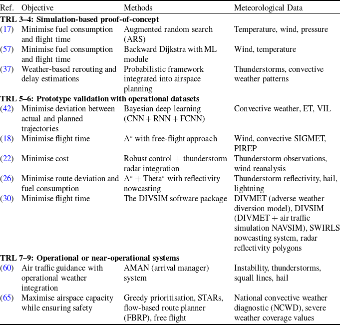
Table 7 highlights selected studies that demonstrate the application of route optimisation frameworks across different technology readiness levels (TRLs). Instead of broadly classifying these works as ‘real-world’ or ‘semi-operational’, the discussion explicitly positions them along the TRL spectrum, which provides a more rigorous assessment of technological maturity.
Summary of route optimisation frameworks positioned within the TRL spectrum

In this context, approaches validated only in simulation environments are positioned at TRL 3–4, reflecting proof-of-concept studies that confirm feasibility under controlled conditions. Frameworks evaluated using operational flight datasets or prototype implementations fall under TRL 5–6, marking the transition from research concepts toward operational prototyping and testing in relevant environments. Finally, solutions that are embedded into air traffic management (ATM) tools or airline dispatch systems are aligned with TRL 7–9, indicating a high degree of maturity and near-operational or fully operational deployment.
By mapping existing contributions to the TRL framework, it becomes possible to assess not only the scientific novelty of these works but also their potential for adoption in operational aviation environments. This structured classification highlights the extent to which meteorological intelligence has moved beyond theoretical models, offering a transparent view of progress toward deployable, data-driven decision support systems in aviation.
Several route optimisation frameworks have been proposed and tested across different stages of technological maturity. As summarised in Table 7, these contributions can be systematically mapped onto the TRL spectrum, reflecting their readiness for real-world deployment.
At the TRL 3–4 level (simulation-based proof-of-concept), methods such as augmented random search for trajectory optimisation [Reference González-Arribas, Baneshi, Andrés, Soler, Jardines and Garca-Heras17] or machine learning-enhanced Dijkstra variants [Reference Xu, Wandelt, Sun, Yang, Jin, Karichery and Drwal57] remain validated only in controlled or simulation environments. Probabilistic rerouting models for convective weather avoidance [Reference McCrea, Sherali and Trani37] also belong to this group, demonstrating feasibility but not yet tested in operational conditions. These studies highlight the potential of AI and optimisation methods but remain limited by their reliance on synthetic or purely historical datasets.
Moving toward TRL 5–6 (prototype validation with operational datasets), approaches begin to incorporate real-world flight and meteorological data. For instance, deep learning-based models for trajectory conformance monitoring [Reference Pang, Zhao, Yan and Liu42], free-flight A* routing with Significant Meteorological Information (SIGMET) and Pilot Weather Reports (PIREP) integration [Reference Kim, Justin, Mavris and Briceno18], and robust control frameworks leveraging thunderstorm radar observations [Reference Garca-Heras, Soler, González-Arribas, Eschbacher, Rokitansky, Sacher, Gelhardt, Lang, Hauf and Simarro22] demonstrate stronger alignment with operational conditions. Similarly, dynamic routing methods such as A* with reflectivity nowcasting [Reference Schilke and Hecker26] and integrated software packages like DIVSIM [Reference Hauf, Hupe, Sauer, Rokitansky, Lang, Sacher, Chan and Sakiew30] use real atmospheric inputs, moving closer to practical application.
Finally, a smaller subset of works has reached TRL 7–9 (operational or near-operational systems). These include weather-aware arrival management systems (AMAN) for traffic sequencing under convective disturbances [Reference Temme, Gluchshenko, Nöhren, Kleinert, Ohneiser, Muth, Ehr, Groß, Temme and Lagasio60] and large-scale automated rerouting frameworks designed to maximise capacity under severe weather constraints [Reference Krozel, Penny, Prete and Mitchell65]. Such implementations directly interact with air traffic management tools and demonstrate the highest maturity, bridging the gap between research and operational deployment.
By explicitly positioning studies within this spectrum, the progression from conceptual simulation to pre-operational validation and near-operational integration becomes evident. This structured perspective not only highlights scientific innovation but also clarifies which methods are approaching real-world applicability in meteorology-driven flight optimisation.
4.6 Research gaps and future directions
Despite the growing body of research on flight route optimisation based on meteorological data, several significant research gaps remain. These gaps limit the applicability, scalability and reproducibility of many proposed approaches. A comprehensive analysis of the reviewed studies reveals limitations in data usage, methodological diversity, evaluation rigor and operational integration.
This section identifies and categorises these gaps into four main areas: (1) limitations in meteorological data utilisation, (2) methodological shortcomings, (3) challenges in evaluation and reproducibility and (4) potential directions for future research. Addressing these aspects is crucial for advancing the field and ensuring that route optimisation models can be reliably applied in dynamic, real-world air traffic management environments.
4.6.1 Gaps in meteorological data utilisation
While many studies incorporate meteorological inputs into route optimisation models, the scope of utilised weather data is often limited to a narrow subset – most commonly wind speed and convective activity. Despite their operational importance in aviation, less emphasis is placed on integrating additional significant atmospheric parameters such as turbulence intensity, icing conditions, visibility or low-level wind shear.
Moreover, most models rely on forecast data from a single source, such as GFS or ECMWF, without comparative evaluation across different meteorological datasets (e.g. Meteorological Aerodrome Report (METAR), SIGMET, ECMWF Reanalysis v5 (ERA5), PIREPs). This lack of data diversity can reduce model robustness and limit the ability to generalise across regions or flight phases.
Another key limitation is the underutilisation of spatiotemporal variability and uncertainty within weather data. Many approaches treat meteorological inputs as deterministic layers rather than probabilistic fields, which can lead to oversimplified route cost estimations and suboptimal flight planning outcomes.
Addressing these gaps would require integrating multi-source, high-resolution and uncertainty-aware weather products that better reflect the dynamic and heterogeneous nature of atmospheric phenomena affecting flight safety and efficiency.
4.6.2 Methodological limitations
Despite the rapid evolution of optimisation techniques, many studies adopt simplified or idealised assumptions that limit their real-world applicability. Many approaches still assume static weather inputs or operate in offline environments without accounting for meteorological conditions’ dynamic and rapidly changing nature during actual flights. A vital review by Simorgh et al. [Reference Simorgh, Soler, González-Arribas, Matthes, Grewe, Dietmüller, Baumann, Yamashita, Yin and Castino79] emphasised the need for climate-optimal aircraft trajectory planning, highlighting that most existing methods inadequately account for long-term environmental impacts such as NOx emissions and contrail formation. The study identified significant methodological gaps in integrating climate-aware constraints into trajectory optimisation models.
Another methodological constraint is the lack of generalisability of proposed models. While some algorithms perform highly in selected case studies or specific airspaces, they are rarely validated across diverse flight corridors, operational contexts or weather regimes. This raises concerns about their scalability and robustness in global aviation scenarios.
Furthermore, although machine learning and metaheuristic methods are increasingly used, little attention is often paid to model interpretability, convergence guarantees or the computational cost of implementation – especially under real-time constraints. Only a few studies provide complexity analysis or assess the feasibility of deployment in existing airline or ATC systems.
To overcome these limitations, future methodologies should focus on adaptive, data-driven, and explainable frameworks that can operate under uncertain, time-varying conditions while meeting operational performance requirements.
4.6.3 Challenges in evaluation and reproducibility
One of the significant obstacles in advancing meteorology-based route optimisation research is the limited transparency and reproducibility of existing studies. A significant portion of the literature does not provide access to the datasets, code repositories, or experimental configurations used – hindering comparative benchmarking and validation by other researchers.
Moreover, evaluation procedures often lack standardisation. Performance metrics vary widely across studies, with some focusing solely on fuel savings, others on route length or delay reduction, and only a few considering safety-related outcomes such as storm avoidance or trajectory deviation. This heterogeneity in evaluation practices limits the ability to draw generalised conclusions about algorithm performance.
Another key concern is the absence of independent validation using unseen flight or weather scenarios. Many models are tested on the same dataset they are trained or tuned on, which raises concerns about overfitting and limited generalisation capacity.
Future research should prioritise open science practices, including the publication of benchmark datasets, shared codebases and standardised evaluation protocols. These practices would foster collaborative progress and allow the field to move toward more trustworthy, repeatable and practically relevant solutions.
4.6.4 Future directions
Based on the gaps identified in previous sections, several promising avenues emerge for future research. First, integrating multimodal meteorological data – combining satellite imagery, radar reflectivity and in-situ reports – could enhance situational awareness and enable more informed decision-making. Such data fusion could support high-resolution weather-aware trajectory optimisation, particularly under convective or low-visibility conditions.
Second, real-time and adaptive decision-making frameworks such as RL remain underexplored in operational flight routing. Unlike traditional models, RL can continuously learn from environmental feedback, adapting dynamically in uncertain atmospheric conditions. Integrating RL with live weather updates may allow for more flexible and resilient in-flight routing solutions.
Third, future efforts should aim to align trajectory optimisation with sustainability goals. This includes incorporating environmental performance indicators – such as CO ${_2}$
and NO
${_2}$
and NO ${_x}$
emissions – into the objective functions of optimisation models. Developing green trajectory frameworks that balance efficiency with ecological impact is especially crucial in the context of climate change and international aviation regulations.
${_x}$
emissions – into the objective functions of optimisation models. Developing green trajectory frameworks that balance efficiency with ecological impact is especially crucial in the context of climate change and international aviation regulations.
Finally, a key research direction involves the development of deployable decision support systems that can be integrated into existing ATM or airline dispatch platforms. These systems must operate within strict time constraints while handling heterogeneous weather inputs, regulatory rules and operational preferences. Collaboration between researchers, meteorologists and aviation authorities will be essential for bridging the gap between theoretical advancements and practical deployment.
5.0 Conclusion and future work
This review provides a structured synthesis of recent studies on flight route optimisation and planning based on meteorological data. Integrating weather parameters – particularly wind, convective activity and turbulence – into optimisation models has significantly enhanced operational safety, efficiency and fuel economy in aviation.
The surveyed studies employed various methodologies, from classical graph-based algorithms to advanced machine learning and hybrid optimisation techniques. These approaches demonstrate promising results, but several challenges persist, including the limited use of diverse meteorological datasets, lack of real-time adaptability and insufficient validation under dynamic conditions.
Recent advances in artificial intelligence, intense learning and reinforcement learning open new opportunities for adaptive, scalable and context-aware optimisation. These data-driven approaches offer the potential to learn from historical and real-time meteorological inputs, enabling more intelligent and more responsive decision-making in flight operations.
Future research should prioritise the development of robust, explainable and computationally efficient frameworks that can integrate high-resolution, multi-source meteorological datasets (e.g. ECMWF Reanalysis v5 (ERA5), Next-Generation Radar (NEXRAD), Ensemble Prediction System (EPS, World Area Forecast System/National Weather Service (WAFS/NWS), Mode-S/ADS-B observations). Such integration would enable optimisation models to capture fine-scale weather dynamics and improve reliability under rapidly changing atmospheric conditions. In addition, future studies should systematically validate proposed methods through large-scale scenario testing and real-world case studies, rather than relying solely on idealised simulations.
Equally important is the alignment of optimisation objectives with sustainability metrics, including quantifiable reductions in fuel consumption, CO2 emissions and operational delays. Addressing these goals not only advances scientific rigor but also supports the decarbonisation targets of international aviation organisations (e.g. ICAO, International Air Transport Association (IATA)). Finally, embedding these models into airline decision-support systems and air traffic management platforms will be critical for translating theoretical advances into operationally viable and industry-adopted solutions.


 Open access