


Introduction
During the Late Chalcolithic period (Table 1) in greater Mesopotamia, what is today Iraq, western Iran, Syria and south-east Türkiye, centralised public institutions able to persuade their wider communities to supply them with labour and goods developed for the first time at a handful of settlements. The site of Uruk-Warka in southern Iraq, for instance, grew in size from a modest village to several hundred hectares by the late fourth millennium BC (Finkbeiner Reference Finkbeiner1991). At its peak, Uruk-Warka featured numerous monumental structures, usually interpreted as temples, with evidence for extensive record keeping and the redistribution of goods. The practicalities and impetus behind the development of these institutions, their local and regional manifestations and their longer-term trajectories have stood at the centre of a long-running debate. Work by the Sirwan Regional Project (SRP) along the lower Sirwan/upper Diyala river in north-east Iraq has begun to reveal a new regional history of Late Chalcolithic institutional emergence and abandonment. As part of this project, the new data presented here offer the opportunity to re-engage with unresolved questions regarding the nature of Late Chalcolithic social and economic organisation through a bottom-up, practice-centred approach.
Chronological period labels and approximate dates.

Research context
Scholars working within the systemic-adaptive frameworks of the 1960s and 1970s saw the monumental structures and bureaucratic implements at Uruk and other southern Mesopotamian sites as material reflections of successful state control over a highly specialised and hierarchically organised workforce (Wright & Johnson Reference Wright and Johnson1975; Nissen Reference Nissen1988). What came first, urbanism or the state, varies among these models, but both were predominately thought of as solutions to demographic and organisational problems (Adams Reference Adams1966; Johnson Reference Johnson1973; Wright & Johnson Reference Wright and Johnson1975; Wright Reference Wright1977; Nissen Reference Nissen1988: 66–69). World systems perspectives framed the establishment of culturally southern settlements in northern Mesopotamia and elsewhere as trade colonies, interpreting them as the natural expansive consequences of ‘pristine’ state formation, and local institutional development as the result of peripheral emulation (Algaze Reference Algaze1993).
Excavations in Syria and south-east Türkiye, however, demonstrate that Late Chalcolithic societies developed large-scale settlements and public institutions independent of, as well as prior to, intensified contact with the Uruk world, and that southerners not only settled in colony sites, but integrated to varying degrees into local communities, over which they did not exert economic or other forms of control (Rothman & Peasnall Reference Rothman and Peasnall1999; Stein Reference Stein1999; Gibson et al. Reference Gibson2002; Oates et al. Reference Oates, McMahon, Karsgaard, al-Quntar and Ur2007; Frangipane Reference Frangipane2010). While a greater variety of raw materials and manufactured goods now reached Mesopotamia than in preceding periods (Pollock Reference Pollock1999: 113–14), an absence of evidence for the large-scale movement of goods suggests that Uruk migrants, rather than being traders were more likely disenfranchised groups or refugees looking to escape the extractive demands of emergent statehood in southern Mesopotamia (Johnson Reference Johnson1988–1989; Schwartz Reference Schwartz and Rothman2001; Pollock Reference Pollock and Rothman2001).
Other research challenges earlier assumptions of highly centralised Late Chalcolithic economies by demonstrating the continued importance of household-level production, limited levels of economic specialisation and the general absence of evidence for production activities in or around monumental buildings. Late Chalcolithic institutions, thus, may have mainly extracted resources and goods from their communities rather than become directly involved in their production (Pollock Reference Pollock1999: 93–116). A central aspect of Late Chalcolithic institutional activity is the distribution of food, plausibly in compensation for labour rendered. Evidence for this includes the thousands of crudely made serving bowls found in and around monumental structures and other large buildings, and the bureaucratic oversight cast over their distribution (Nissen Reference Nissen1970: 136–38; Johnson Reference Johnson1973; Frangipane Reference Frangipane and Rothman2001; Pollock Reference Pollock and Bray2003). A further indication is the concentration of food preparation areas in institutional spaces, and their absence from private houses at some settlements (Pollock Reference Pollock1999: 98–100).
How hierarchical social life became as a result of the emergence of such institutions remains the subject of intense debate. A lack of archaeological and iconographic evidence for centralised and hierarchical state power early in the Late Chalcolithic period has led to suggestions, based on similarly limited archaeological data, that Mesopotamian cities were, sensu latu, democratically governed by their citizens (Graeber & Wengrow Reference Graeber and Wengrow2021: 298–304). At the same time, the high economic growth hypothesised for these early cities may have benefitted not an emergent elite, but urban communities more generally (Green et al. Reference Green, Wilkinson, Wilkinson, Highcock and Leppard2024: 48–52). By the later fourth millennium BC, however, the picture becomes more complex: some aspects of southern economies appear to have remained decentralised, while other data point to the existence of large-scale and hierarchically ordered specialised production enterprises at the same time as figures of authority (‘man in the net skirt’) begin to appear in Mesopotamian iconography (Pollock Reference Pollock1999: 101, 103).
Factors influencing institutional longevity and demise have received some consideration. Frangipane (Reference Frangipane2009: 31), for instance, hypothesises that the extent to which institutional households were able to transform local economic and sociopolitical orders, alongside differences in the degrees of social stratification and urbanisation, were key factors determining their longer-term trajectories. What has, as yet and with few exceptions (e.g. Pollock Reference Pollock and Rothman2001), received almost no empirical attention is how local populations in different regions reacted to, or against, institutional development, and which sociocultural mechanisms or strategies they may have employed to counteract unwanted centralising tendencies (see e.g. Angelbeck & Grier Reference Angelbeck and Grier2012).
As this brief and necessarily selective summary shows, much remains unknown about Late Chalcolithic urbanism and the emergence and subsequent development of public institutions. Many aspects of ongoing debates, moreover, are hamstrung by overly rigid, top-down conceptual frameworks and classificatory schemes—social complexity, urbanism, the state—and by significant deficiencies in the empirical data that they draw upon (on the latter, see chapters in Rothman Reference Rothman2001). In response, we have adopted a local, bottom-up and practice-centred approach that allows us to develop a detailed, long-term understanding of the public institutions at Shakhi Kora and their relationships and interdependencies with contemporary communities, on-site and in the wider region.
Excavations at Shakhi Kora
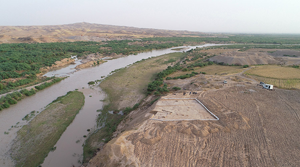
The site of Shakhi Kora, which measured at least 8ha during the Late Chalcolithic period, sits atop a Pleistocene terrace flanking the Sirwan river approximately 10km to the south-west of the modern town of Kalar, in the Kurdistan Region of Iraq (Figure 1). It overlooks a strategic geographic bottleneck, where the Sirwan, a major tributary of the Tigris, forces its way through one of the westernmost outlier ranges of the Zagros foothills (Figure 2). A single painted Ubaid surface sherd and intrusive LC1 pottery (see Table 1) in later contexts may point to a fifth millennium BC origin for the settlement. The overwhelming majority of recovered materials, however, date to between the late LC2 and LC5, followed by what appears to be a more ephemeral late fourth to early third millennium BC presence. This makes Shakhi Kora the largest and most long-lived Late Chalcolithic settlement along the Sirwan/Diyala river.
Map showing the location of Shakhi Kora (figure by authors).

Aerial view of the 2023 exposure in Area I at Shakhi Kora (photograph by authors).

Shakhi Kora was first recorded by the Garmian Department of Antiquities in April 2018 after reports of illicit digging. The SRP, in collaboration with the Garmian Department of Antiquities and with the permission of the General Directorate of Antiquities in Erbil, carried out a survey and test sounding in the same year to assess the damage and to gain an understanding of the site's historical significance. Larger-scale excavations were subsequently carried out in 2019, 2022 and 2023 alongside a magnetic gradiometer survey. Results of the latter indicate the likely presence of several large buildings at the site, as well as open spaces, a potential perimeter wall and more densely built-up areas, suggesting a likely—though as yet not intensively explored—urban environment (Figure 3).
Results of the 2023 magnetic gradiometer survey at Shakhi Kora (figure by authors).

Excavations to date have focused on two distinct areas to expose a total area of 728m2. So far, we have identified six occupation phases: Phases 1 and 2 can be assigned to the early centuries of the fourth millennium BC (later LC2–early LC3), Phases 3 and 4 to the LC3–early LC4 and Phase 5 to the LC4–5 (see Table 1). Phase 6 dates to the Jemdet Nasr period and perhaps slightly later.
The largest exposure to date, which we focus on in this article, is Area I on the eastern, river-facing edge of the site. Here, we encountered a sequence of consecutive architectural spaces closely associated with the production and distribution of food at considerable, supra-household scales during Phases 2–4. This is followed by a further institutional household in Phase 5 which has been exposed over roughly 600m2 to date. Charcoal-derived radiocarbon dates place Phases 2–5 between c. 3941 and 3377 cal BC (at 95.4% confidence; AA116085 and AA114846, for more detail, see Glatz et al. Reference Glatz2024).
Phase 2 contexts were exposed over a 5 × 5m area at the current bottom of the stepped, eastern part of trench AA21 in Area I. These consist of a series of rooms partitioned by a long wall that is three mudbricks wide (Figure 4). Large quantities of pottery, predominantly open vessels—so-called wide flowerpots and bevelled rim bowls—were retrieved from several architectural units, while a hearth and other ashy deposits contained large numbers of faunal remains.
View of the Phase 2 exposure in Area I (photograph by authors).

The end of Phase 2 is marked by a levelling of the area in preparation for the next structure. Phase 3 retains some of the architectural layout of the preceding phase, but the smaller rooms of Phase 2 now give way to a larger indoor space, of which approximately 20m2 have been excavated. Several stacks of complete, upturned bevelled rim bowls arranged in pairs were found in situ on the floor surface against the southern wall (Figure 5). A grinding slab sat on the floor in the northern corner of the trench.
Stacks of upturned bevelled rim bowls on the floor of the Phase 3 space in Area I (photograph by authors).

The floor of this large indoor space was covered by a roughly 0.60–0.70m deep collapse horizon, which contained broken mudbrick and soft, mostly blackened soil. It also included large quantities of complete and fragmentary pottery, especially bevelled rim bowls and wide flowerpots, alongside chipped stones and grinding stones, again suggesting a primary function in food processing and distribution. Overall, the formal characteristics of the pottery assemblage of Phase 3, which includes bevelled rim bowls but is dominated by wide flowerpots, point to a date in the LC3, as does a charcoal-derived radiocarbon date of c. 3780–3648 cal BC (95.4% confidence, AA114848, for more detail, see Glatz et al. Reference Glatz2024). What caused the destruction of the Phase 3 building remains unclear.
Phase 4 consists of a deliberate filling and levelling event that sealed the destruction fill of Phase 3 with a layer of soft but very compacted soil mixed with large quantities of pottery, and a subsequent floor. The ceramic assemblage associated with this floor and an ashy hearth area point again to food production and distribution.
Phase 5 presents a further re-building event in Area I, which includes the construction of a large hall with at least two, but possibly originally three, rows of squared pillars made of plastered rammed earth (Figure 6). The pillared structure was flanked by a food production area in the east that overlies the earlier, and functionally very similar, spaces of Phases 2–4. A contemporaneous storage area and outdoor space are located to the west, and a discard area for bevelled rim bowls and food remains is located to the south. A mudbrick wall, which runs into the northern trench section, may delimit the pillared hall in the north.
View of the Phase 5 pillared structure in Area I (photograph by authors).

The Phase 5 pillared hall was equipped with an extensive underfloor drainage system, whose purpose-made clay pipes are comparable with examples from Tell Brak (Emberling et al. Reference Emberling2003: 8, figs. 9 & 10), Habuba Kabira (Kohlmeyer & Ludwig Reference Kohlmeyer and Ludwig2021: 148, tab. 35.3) and Girdi Qala (Vallet Reference Vallet2018: 11–12, fig. 7) (Figure 7). A further drain was constructed using nine large jars, the bases and rims of which had been chopped off to allow stacking, and a large ceramic cylinder (Figure 6).
Underfloor drainage systems in the Phase 5 pillared hall (photograph by authors).

Found associated with one of the pillars, was an in-situ collection of pottery vessels, bones in an ashy matrix, what may be two degraded braziers and several squared and amorphous artefacts that may be the remains of food (Figure 8A & B). These items seem to have formed part of a deliberate depositional act, most likely one or more ritual offerings. A stone figurine of a reclining ram (Figure 8C), comparable to examples from the Eanna complex at Uruk (Bahrani Reference Bahrani2017: 50, 67), was found a few centimetres above this assemblage in Phase 5 deposits.
Possible ritual pillar deposits (A & B) and a reclining ram figurine (C) (figure by authors).

Activities in the eastern food production area were centred on an L-shaped wall feature that was surrounded by large numbers of in situ complete and fragmentary storage, cooking and consumption vessels, including large numbers of bevelled rim bowls and chipped and groundstone artefacts (Figure 9A). A pebbled floor led northwards towards a U-shaped mud-brick feature that likely contained an oven.
Cooking and serving area to the east of the pillared hall (A) and a storage area to the west (B) (figure by authors).

A row of storage jars aligned along a north-south running mudbrick wall, and with bowls and cups strewn among them, flank the pillared hall to the west (Figure 9B). To the south, an ashy midden area contained over one hundred bevelled rim bowls, other vessels and animal bones. A cylinder seal from the topsoil above the pillared hall and finds of clay wall cones in almost all excavated contexts further emphasise the institutional character of the structure.
The Phase 5 monumental building was abandoned with no signs of violent attack, conflagration or clearance sometime in the LC5 and remained so for long enough for the mudbrick walls to erode and encase extensive floor assemblages and installations. This was followed by one or more smaller-scale reoccupation event(s) during the later fourth to early third millennia BC (Phase 6).
Cultural practices and emergent political economies
Phases 1–3 at Shakhi Kora are distinctly local in character; consecutive communities participate in a north-western Zagros piedmont sphere of cultural practice that is oriented towards northern Mesopotamia. Wide flowerpots dominate the assemblages of Phases 2 and 3, with club-headed bowls, bowls with internally bevelled rims and band rim jars also attested. Chaff temper predominates, while grey wares are comparatively rare. A small number of southern Mesopotamian or Uruk pottery types, including ‘proto’-bevelled rim bowls and some spouted vessels, are already present in the earliest excavated contexts (Phase 1), while coarse, chaff-tempered bevelled rim bowls make up a substantial portion of the Phase 2 and 3 assemblages. Overall, this material finds its closest parallels at Girdi Qala/Logardan and Kani Shaie in the west-central Zagros piedmonts (Vallet et al. Reference Vallet, Baldi, Naccaro, Rasheed, Saber and Hamarasheed2017; Renette et al. Reference Renette, Abu Jayyab, Gibbon, Lewis, Abdullkarim, Cabral and Tomé2021).
Phase 4 sees the introduction of a wider range of southern Mesopotamian pottery forms, including spouted jars and jars with simple everted and band rims. Pattern burnished sherds also first appear in this phase, as do nose-lugged globular jars. Phase 4 also represents the earliest contexts in which the quantity of bevelled rim bowls overtakes wide flowerpots, while most of the pottery, including Uruk forms, continue to be chaff-tempered. This assemblage has parallels at Tell Rubeidheh (McAdam & Mynors Reference McAdam, Mynors and Killick1988) and Tell Hassan (Nannucci Reference Nannucci and Mazzoni2012) in the Hamrin region, as well as at sites further north such as Kani Shaie (Renette et al. Reference Renette, Abu Jayyab, Gibbon, Lewis, Abdullkarim, Cabral and Tomé2021) and Gurga Chiya (Lewis et al. Reference Lewis, Quinn and Carter2020).
Lipid residues from 10 bevelled rim bowls from Phase 3–5 contexts were recently analysed using gas chromatography-mass spectrometry (GC-MS) and gas chromatography-combustion-isotope ratio mass spectrometry (GC-C-IRMS), as well as fatty acid and compound-specific carbon stable isotope analyses (for a detailed discussion of methods and results, see Perruchini et al. Reference Perruchini2023). Results indicate that the bevelled rim bowls were used to serve and consume a range of different foods, including meat- and possibly also dairy- and seed/plant-based products, across different occupation phases. The majority appear to have been used to distribute meat- or marrow-based broths or stews. The archaeobotanical assemblage from Shakhi Kora includes emmer and einkorn wheat, barley and fig, while faunal assemblages are dominated by caprines—with goats more numerous than sheep in the relatively small assemblage excavated to date—followed by cattle, pig, dog and deer. The faunal remains from areas with large numbers of bevelled rim bowls and wide flowerpots point to marrow and grease extraction as one of the main butchery and cooking techniques on site.
These food preferences make it likely that animal husbandry played an important role—and perhaps a more important one than cereal cultivation—in the early institutional economies of Shakhi Kora. Located in the so-called ‘zone of uncertainty’ (Wilkinson Reference Wilkinson2000), Shakhi Kora sits between the 180 and 300mm isohyets, in a region where rain-fed agriculture is possible but subject to sometimes dramatic interannual fluctuations in precipitation, and where an emphasis on caprine husbandry may buffer against such environmental risks.
Preliminary faunal stable isotope results tentatively support the interpretation of herd management at Shakhi Kora. Cyclical variation in the intratooth oxygen isotope curves of two goat molars from Phase 3 contexts indicate that the caprine breeding season was being deliberately manipulated to extend birthing periods (Glatz et al. Reference Glatz2024). This herd management practice, which suggests an attempt to intensify aspects of animal husbandry production by extending the period of milk availability, is attested in later textual sources (Oppenheim & Hartman Reference Oppenheim and Hartman1945: 169), but the Shakhi Kora evidence indicates a significantly earlier emergence in the region of modern-day Iraq. At the same time, strontium isotope ratios from tooth enamel suggest herds were grazed in the vicinity of the site, while carbon isotopic ranges indicate a diet of predominantly C3 plants (these data are presented and discussed in full in Glatz et al. Reference Glatz2024). Animals consumed by the Phase 3 institutional household at Shakhi Kora, thus, were not subject to transhumant or other mobile herding practices. The local isotope signatures also point to a potentially very limited geography of institutional power.
While changes occur more gradually in Phases 2–4, a comparatively abrupt cultural shift takes place at the beginning of Phase 5 (LC4–5). Matching the cultural character of the pillared hall structure and its small finds, the Phase 5 pottery assemblage also firmly ties Shakhi Kora into a culturally southern Uruk world. This includes technological choices such as the use of mineral temper. Bevelled rim bowls now dominate the repertoire of open forms, with sharply carinated bowls, carinated cups and small numbers of incurved rim bowls also present. Continuing from earlier phases are inwardly bevelled rim bowls and string-cut cups with narrowed, tapered rims. A small number of very fine, tapered rim bowls are also present in lower frequencies. Several globular jars with nose lugs and triangular incised decorations, both pithos-sized and miniatures, are attested, as are tall bottles or ‘torpedo jars’, a sizeable number of which have drooping spouts.
Regional perspective
Results of the SRP's regional survey over an area of approximately 4000km2 along the course of the lower Sirwan and its tributaries show that the Late Chalcolithic community at Shakhi Kora formed part of a settlement landscape that was dominated by small hamlets and villages with site sizes clustering between 1ha and 2ha (Figure 10). The overall site count for the Late Chalcolithic is 42, presenting a rather dramatic increase in site numbers from the preceding Ubaid period (n = 18), which includes an increase in overall settled area. From the Ubaid to the early part of the Late Chalcolithic (n = 16), site numbers remain broadly stable, although only five sites with Ubaid surface assemblages continue to be occupied in the early phases of the Late Chalcolithic. Early Late Chalcolithic sites cluster in the southern plains to the west of the Sirwan river, and in the north-eastern Hawasan river valley and adjacent upland plains. Settlement numbers increase to a total of 26 sites in the second part of the Late Chalcolithic, the later LC3–5.
Map showing the distribution of fourth millennium BC sites in the SRP survey region (figure by authors).

The only larger sites in the lower Sirwan valley, which may have acted as regional centres of some description, are Shakhi Kora measuring at least 8ha and Mala Kunar I at approximately 4ha. Both sites are located in the comparatively fertile plains south of the modern town of Kalar, and both show limited evidence for earlier and later occupation. In contrast to Shakhi Kora, surface survey at Mala Kunar I produced no southern Uruk materials, including bevelled rim bowls. Sites in the northern uplands range from very small to a maximum of 2ha in size, with no spatial hierarchy discernible. The very limited presence of Uruk-related material culture suggests that upland Late Chalcolithic communities also showed limited interest in southern material culture and likely operated outside of Uruk-related cultural and economic networks.
Against centralisation
A radiocarbon date places the abandonment of the pillared hall complex of Phase 5 at Shakhi Kora after c. 3631–3377 cal BC. This date range lies outside of the calibration plateau that affects radiocarbon readings between c. 3350 and 3000 BC (Petrie Reference Petrie, McMahon, Crawford and Oates2014: 147–50), and should thus be considered reliable, if affected by a rather large error margin. The latter is mitigated by the relative chronological range of the cultural assemblage of Phase 5, which sits comfortably in the LC4–5 (see Table 1). Thus, as far as can be ascertained at this moment, the abandonment of Phase 5 structures in Area I took place sometime before the 5.2 ka global climate event, which resulted in a dramatic drop in precipitation that would have adversely affected regions dependent on rainfed agriculture.
The end of the centuries-long, first local and then Uruk-related experimentations with institutional forms of sociopolitical organisation in the lower Sirwan valley cannot, therefore, be explained by climate change, as some have proposed for northern Mesopotamia (Weiss & Bradley Reference Weiss and Bradley2001; Staubwasser & Weiss Reference Staubwasser and Weiss2006). Instead, our data point to the rejection of urbanism and public institutions by local populations, which by the LC4–5 may have developed much more centralising and hierarchical socioeconomic structures while also manifesting as culturally different from earlier, more local institutions at Shakhi Kora.
SRP survey results indicate a post-LC5 surge in the number of small to very small settlements in the region (n = 32), and all have noticeably limited surface collections. Only half of LC3–5 sites in the region, including Shakhi Kora and Mala Kunar I, continue to be occupied into the final fourth to early third millennium BC, with more sites being abandoned in the southern plains than in the northern uplands. The extent of the Phase 6 occupation at Shakhi Kora is still being investigated but appears to have been less extensive and more ephemeral in terms of architecture, which points to a substantial transformation in community organisation.
Overall, we seem to be seeing a dispersal of populations, some of which were previously concentrated at larger Late Chalcolithic sites, who are voting with their feet by abandoning Late Chalcolithic settlements and forming new communities that show no signs of regional-level integration or centralisation. Frequent site abandonment and a lack of clearly identifiable spatial hierarchies also characterise settlement patterns in subsequent millennia and appear to have formed part of a local cultural repertoire that was regularly enacted to counter local and external centralising tendencies (Glatz et al. Reference Glatz2024).
Conclusions
Excavations at Shakhi Kora, the largest Late Chalcolithic site in the lower Sirwan/upper Diyala river valley, have revealed four consecutive institutional households dating from the later LC2 to the LC5, which find broad functional comparisons at Tell Brak TW 19-18 (Oates et al. Reference Oates, McMahon, Karsgaard, al-Quntar and Ur2007), Tepe Gawra VIIIA-C (Rothman Reference Rothman2002) and Arslantepe Temple C (Frangipane Reference Frangipane2012), contributing a new regional history of Late Chalcolithic sociopolitical development. The latest of these public institutions (Phase 5) presents as a monumental, pillared structure with an extensive subfloor drainage system and auxiliary spaces, whose material culture is almost exclusively southern Mesopotamian. The preceding Phases 2–4 have been exposed over a more limited area so far, but a continuity in the food-related functionality of these spaces, and the overabundance of bevelled rim bowls and wide flowerpots in each phase, strongly suggest a comparable scale and function pre-dating the Phase 5 horizon. The cultural material from these earlier phases is, however, of a distinctively local character. Preliminary material and faunal analyses suggest that bevelled rim bowls were used in the distribution of meaty or marrow-flavoured soups or stews, perhaps in compensation for labour rendered, and that caprines played an important part in the local economy. Stable isotope results indicate the intensive management of caprine herds in the close vicinity of the site, which may attest to the limited geographical scale of early institutional extraction. Both the stratified record at Shakhi Kora and regional survey results show that this first experiment with urbanism and public institutions in the Sirwan region was abandoned in the later fourth millennium BC, and seemingly not revisited as a model for local social organisation for at least 1500 years. Frequent site abandonment and small settlement sizes remained a long-term local mechanism to counteract centralisation.
Acknowledgements
We are grateful to Kaify Mustafa Ali, Director General of Antiquities for the Kurdistan Region of Iraq, and his team for their support and assistance, as well as to Kamal Rasheed Raheem, the former director of the Sulaymaniyah Directorate of Antiquities. We also thank Nawzad Abdullatif, Mohammed Ali, Sarwat Hamdan, Hoshiar Hasan, Jamal Mohammed, Ahmed Ismael and Imad Ismael, who acted as our representatives on site.
Funding statement
This research has been supported by the G.A. Wainwright Fund, the British Institute for the Study of Iraq, the National Science Foundation (1724488), The British Academy (CRF\103772), the Alexander von Humboldt Foundation (GBR1189411HFST-E) and the Gerda Henkel Foundation (AZ 34/F/22).


 Open access