


Introduction
Cahal Pech is a civic-ceremonial centre that was occupied by the ancient Maya for nearly 2000 years (c. 1200 cal BC–cal AD 900). The site is in the modern town of San Ignacio, Cayo District, in west-central Belize. A 2019 survey of the largest plaza (Plaza B) tested the efficacy of archaeological geophysics (AGP) for detecting subsurface features in the conserved site (Figure 1). Results of fluxgate gradiometry indicated several magnetic anomalies and excavation of one of these, located in the plaza’s south-eastern corner, verified that it was an infilled pit feature containing a chert cache (Figure 2). This is the first cache composed entirely of chert debitage found at the site, radiocarbon dating also confirms that it is one of the oldest known Preclassic lithic caches in the Maya lowlands (Figure 3, Table 1). These results demonstrate the successful application of AGP in a Maya plaza, enabling minimally invasive excavations that respect long-term conservation efforts.
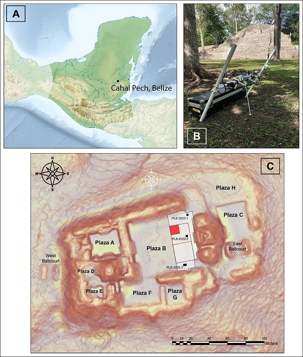
A) The location of Cahal Pech in the Maya lowlands; B) fluxgate gradiometer in Plaza B; C) AGP survey grid and Plaza B excavation on lidar map (∼1 M) (figure by authors).

Figure 1 Long description
The image consists of three elements: a map, a photograph, and a survey grid. The first element is a map showing the location of Cahal Pech in the Maya lowlands. The second element is a photograph of a fluxgate gradiometer placed in Plaza B. The third element is a lidar map displaying the AGP survey grid and the excavation site in Plaza B. The survey grid is marked with specific areas labeled PLB-2022-1, PLB-2022-2, and PLB-2022-3, and the map includes various plazas such as Plaza A, Plaza B, Plaza C, Plaza D, Plaza E, Plaza F, Plaza G, and Plaza H. The map also features a scale in meters and a compass rose for orientation.
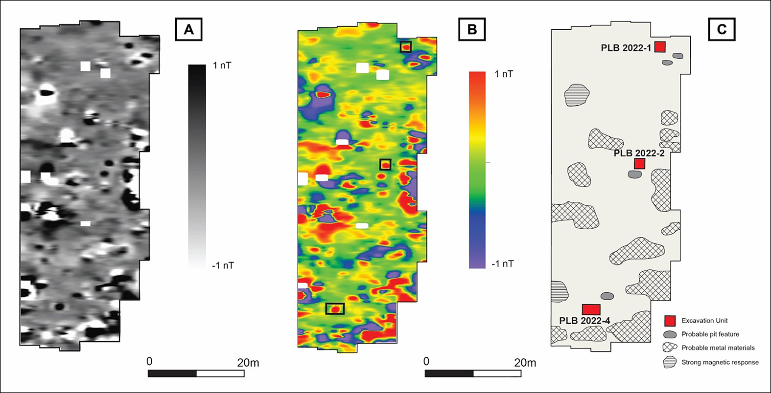
Results of fluxgate gradiometer survey shown as a greyscale plot (A) and a colour contour plot (B); C) interpretive plot of the magnetic responses (figure by authors).

Figure 2 Long description
The image consists of three panels labeled A, B, and C. Panel A shows a greyscale plot of the results from a fluxgate gradiometer survey, indicating magnetic anomalies in Plaza B at Cahal Pech. The plot uses a grayscale color scale ranging from -1 nanotesla to 1 nanotesla. Panel B presents a color contour plot of the same survey results, with colors ranging from blue (indicating lower magnetic values) to red (indicating higher magnetic values). Panel C is an interpretive plot of the magnetic responses, highlighting excavation units, probable pit features, probable metal materials, and strong magnetic responses. The interpretive plot includes labels for specific excavation units such as PLB 2022-1, PLB 2022-2, and PLB 2022-4. The overall structure of the image shows a grid layout with clear demarcations of different areas within Plaza B, providing a detailed visualization of subsurface features detected through archaeological geophysics.
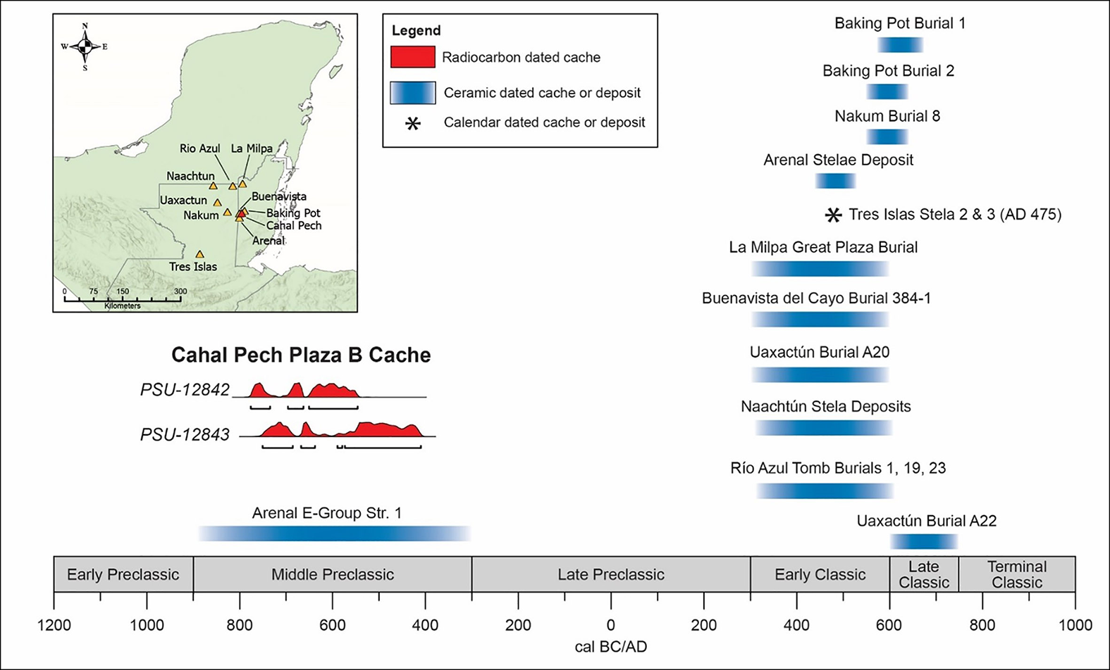
Chronological distribution of chert debitage caches and deposits from the Maya lowlands (figure by authors, modified after Andrieu Reference Andrieu and Masson2020).

Figure 3 Long description
A map of the Maya lowlands highlights the chronological distribution of chert debitage caches and deposits. The map includes various sites such as Rio Azul, La Milpa, Naachtun, Uaxactun, Nakum, Buenavista, Cahal Pech, Arenal, and Tres Islas. Different colors and symbols indicate the types of caches or deposits, including radiocarbon dated, ceramic dated, and calendar dated. The timeline at the bottom spans from 1200 BC to AD 1000, marking significant periods such as Early Preclassic, Middle Preclassic, Late Preclassic, Early Classic, Late Classic, and Terminal Classic. Specific caches and deposits are labeled with their respective sites and dates, providing a detailed overview of the chronological distribution of these artifacts.
Radiocarbon dates from the chert cache (calibrated using OxCal v.4.4).

As one of the earliest monumental sites in the Belize Valley, Cahal Pech provides an ideal context for studying Preclassic lowland Maya ceremonial behaviour. Monumental architecture appears during the Middle Preclassic period (900–300 cal BC), reflecting ceremonial traditions associated with institutionalised inequality and sociopolitical integration (Ebert et al. Reference Ebert2021). Among these traditions, dedicatory caches are well documented across the Maya lowlands and contemporaneous Mesoamerican centres, demonstrating emerging ideological systems tied to rulership (Awe Reference Awe1992; Peniche May Reference Peniche May2016; Porter Reference Porter2020). The caches consist of intentionally placed objects interred during construction phases to consecrate buildings. At Cahal Pech, deposits provide evidence of dedicatory ceremonies beginning in the terminal Early Preclassic (1200/1100–900 cal BC), underscoring the role of caching in early ceremonial traditions.
By the Classic period (AD 300–900/1000), layering chert flakes and other items over elite burials was a widespread tradition (Andrieu Reference Andrieu and Masson2020; Horowitz et al. Reference Horowitz2020). The Maya believed chert was imbued with a life force and embodied the lightning god, K’awiil, suggesting a ritual logic for the presence of chert debitage in elite ceremonies and ancestor veneration (Horowitz et al. Reference Horowitz2024). This cache may represent a period of significant transformation at Middle Preclassic Cahal Pech, when a once-community-focused village became the seat of an elite dynasty.
Geophysical survey and excavations in Plaza B
Recent AGP projects in the Maya lowlands report varied success with different survey methods (e.g. Cap Reference Cap2015; Skaggs et al. Reference Skaggs2016). In the first multi-instrument AGP survey at Cahal Pech, researchers evaluated several methods, including single-axis fluxgate gradiometry, multi-depth electromagnetic conductivity, magnetic susceptibility and ground-penetrating radar (Figure 1). Gradiometry successfully identified anomalies in Plaza B, an area of the acropolis where ritual caches had previously been recovered (Peniche May Reference Peniche May2016; Porter Reference Porter2020). Data were collected with a Bartington 601 instrument using 1m-spaced traverse lines with readings taken every 125mm and parameters set at ±100nT. Numerous magnetic responses were collected within this range, including monopolar positive, simple dipolar and complex dipolar types (Figure 2). Data were downloaded from the instrument and processed in the field using TerraSurveyor software. Processing steps included: de-spiking, de-striping, low-pass Gaussian filtering and clipping. Based on these results, three monopolar positive responses were identified and targeted for exploratory excavation.
Excavators placed a unit (PLB-2022-4) to ground-truth the south-eastern anomaly in Plaza B. Here, we uncovered a dense concentration of chert debitage beneath three sequential plaster floors (Figure 4). The debitage was 100–200mm deep and surrounded by a semi-circle of flat stones that defined the deposit’s boundaries. More than 6500 secondary and tertiary flakes, ranging in size from approximately 3–40mm, were recovered from within a circular depression approximately 1m in diameter (Figure 4). The stratigraphic level of the deposit corresponds to the third and fourth construction phases of Plaza B, when early elites expanded monumental architecture to create spaces for large ceremonial events.
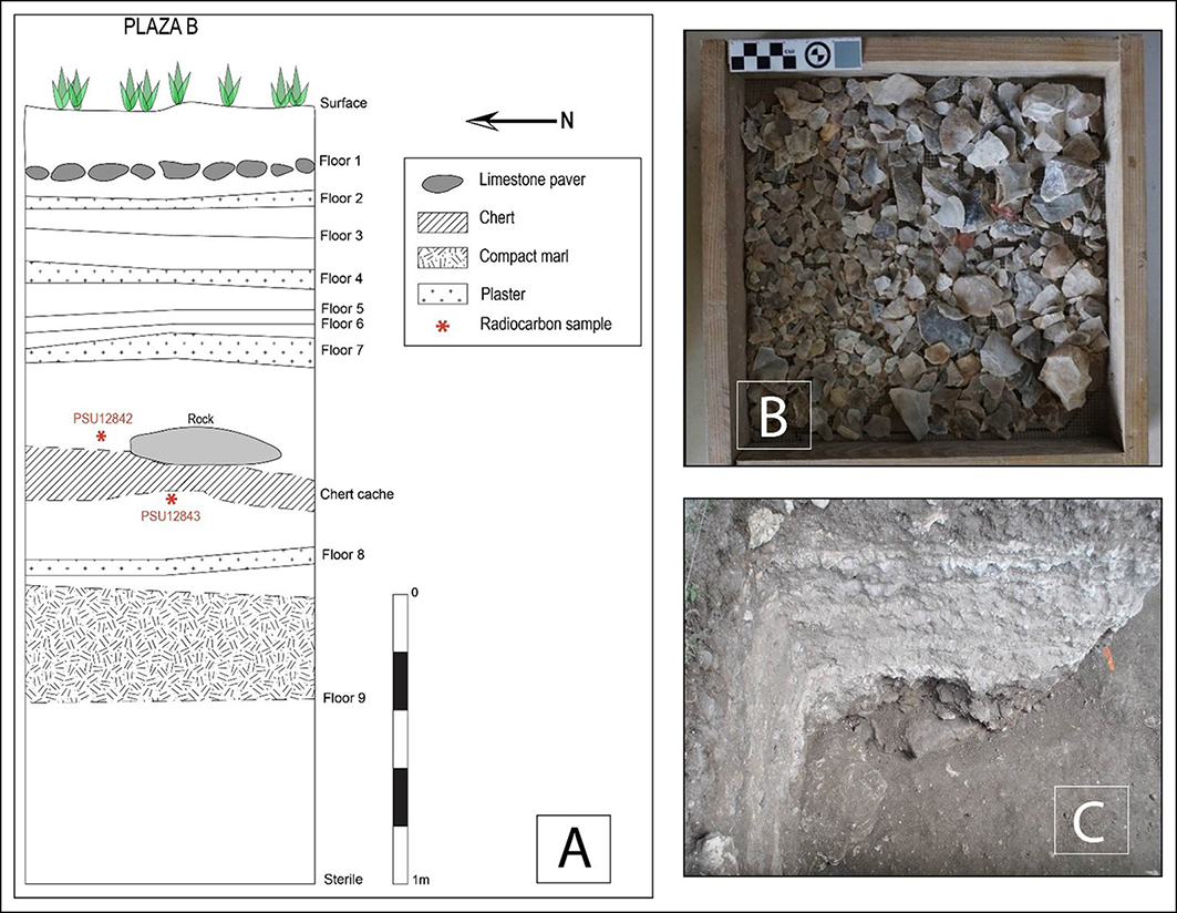
A) East wall profile of unit PLB-2022-4 with chert cache and associated radiocarbon samples; B) sample of lithics from the cache; C) the cache in situ in unit PLB-2022-4 (figure by authors).

Figure 4 Long description
The image presents a detailed cross-sectional diagram of an archaeological excavation site labeled as Plaza B. The diagram illustrates multiple floor layers, each distinctly marked and labeled from Floor 1 to Floor 9. The surface layer is depicted with green grass. Below the surface, Floor 1 to Floor 7 are shown with various materials such as limestone pavers, chert, compact marl, and plaster. Floor 8 contains a chert cache with labeled radiocarbon samples PSU12842 and PSU12843. Floor 9 is marked as sterile. The diagram includes a legend explaining the symbols used for different materials. Additionally, there are two photographs: one showing a sample of lithics from the cache and another showing the cache in situ within the excavation unit PLB-2022-4.
Several features make the Plaza B chert cache a unique addition to the history of the site and to the scholarship of dedicatory caching. First, the distinctive composition of the cache represents a departure from contemporaneous caches at the site and at other regional centres. At least 19 other caches have been found in Plaza B, most dating to the Middle Preclassic and containing various materials (Peniche May Reference Peniche May2016; Porter Reference Porter2020). On the south-eastern flank of Plaza B in Structure B4, caches from the terminal Early Preclassic contained deposits of chert flakes, jade, marine shell and human remains (Awe Reference Awe1992: 341–42). At the site of Arenal, a dense chert deposit was uncovered above multiple burials, composed mostly of bifacial thinning flakes as well as numerous shell beads and some chert bifaces, hammerstones, and other tools (Horowitz et al. Reference Horowitz2020: 292). In contrast, the cache at Cahal Pech lacks blades and tools and is comprised entirely of chert. Second, based on the high volume of microdebitage found in two soil samples from the surrounding soil matrix, we argue the cache is in its primary context, constructed in situ.
Two charcoal samples collected from directly above and below the cache date it to the Middle Preclassic, between 780 and 410 cal BC (Figure 3 & Table 1; PSU-12842 and PSU-12843 at 95.4% confidence; date modelled in OxCal v.4.4 using the IntCal 20 calibration curve; Bronk Ramsey Reference Bronk Ramsey2009; Reimer et al. Reference Reimer2020). These samples confirm that this is one of the oldest lithic deposits found in the Maya lowlands to date, and the only chert cache in the region with secure radiocarbon dates.
Conclusion
Identification of early caches is challenging, even at sites with well-documented construction phases, such as Cahal Pech. Preclassic contexts lie deeply buried (>3m) beneath later Classic period (AD 300–900/1000) architecture. This successful use of fluxgate gradiometry highlights its potential for detecting caches and other deposits in similar contexts in the Maya lowlands.
Acknowledgements
We gratefully acknowledge the sponsorship of the Belize Valley Archaeological Reconnaissance (BVAR) project, the Belize Institute of Archaeology (NICH) and the dedicated efforts of BVAR staff and field students.
Funding statement
The University of Pittsburgh Department of Anthropology and the Dietrich School of Arts and Sciences funded all field research and radiocarbon dating.

 Open access