

‘Les unes veulent de l’eau, les autres n’en veulent pas’ Footnote 1
Liberal politician Charles Sainctelette hit the nail on the head, in his capacity as Belgian Minister of Public Works (1878–1882), when he explained to his fellow parliamentarians how conflicting river interests problematised river management in nineteenth-century Belgium. Some want water; others do not. The agricultural sector, different branches of industry (breweries, water mills), and commercial river transport needed water for their operations, but preferred timing and volumes varied. Meanwhile, too much water could cause harm. Since the law of 18 February 1840 granted state governments full (management) control over all navigable rivers flowing on Belgian territory, the Ministry of Public Works was subsequently put in charge of directing flood prevention measures. Case studies about historical water management teach us that the making of a well-coordinated policy between river functions – that in an ideal world co-existed – largely depended on how successful policymakers were in balancing conflicting river interests.Footnote 2 Similar to elsewhere in Europe, nineteenth-century river governance in Belgium was imbued with belief in the malleability of nature, advised by hydraulic engineers.Footnote 3 This article addresses historical flood problems (causes and effects) between 1840 and 1880 in the confluence area of the rivers Demer and Dijle (NE Belgium), and this in the context of (planned) river regulations. It wants to analyse how governments dealt with flooding: who took responsibility, what river improvement works were suggested, and who eventually benefited from them?
Climate historians label the period under study (1840–1880) as flood-rich, in particular for the Low Countries.Footnote 4 It was also a period wherein Belgian agriculture transitioned (at first) towards more cropland cultivation but (by 1880–1890), following a gradual process, favoured animal husbandry and pastures. During the mid-nineteenth century, the predominantly rural river valleys under study (Demer and Dijle) were, for example, readied for extensive cultivation (through drainage) so that farmers could produce more (increase crop yields) to meet rising populations.Footnote 5 Furthermore and simultaneously to agricultural transitions, a young Belgian state ambitiously developed its industries and thereto facilitated transportation links over land and water. This implicates that new and different functions were attributed to rivers (valleys) that, in turn, required an upgrade of existing water infrastructure, to be rhymed with flood mitigation strategies.
For centuries, humans have changed the natural course of rivers, in function of – to name a few – agriculture, fishing, industry, river transport, and protection against floods. Classic river histories reveal to what degree large European rivers were regulated during the nineteenth and twentieth centuries (turned into ‘organic machines’), under what circumstances and for what reasons.Footnote 6 Available case studies, on the one hand, often investigate river improvement works of national importance and illustrate that central authorities genuinely had economic motives, for instance, to facilitate river transport and other water-demanding industries or to generate hydropower (through a chain of dams and hydropower plants).Footnote 7 The monography titled Confluence, by Sarah Pritchard, investigates evolutions in the technical remaking of the river Rhône and is relevant for the way it contextually analyses competing interests that existed between various societal groups and across governance levels.Footnote 8 On the other hand, complementary research is available about nineteenth-century transport evolutions, that is – regrettably so – seldom referred to in river and environmental histories. Urban historian Greet De Block and economic historian Bart Van der Herten discuss big infrastructure networks (canals, railways, and road networks), in light of Belgium’s developing industry, transport, and communication sectors (nineteenth century). Valuable therein are the indicative, yet detailed reconstructions of government budgets.Footnote 9
However, both branches of knowledge tend to focus on big rivers and infrastructure projects accordingly, on rivers in urban spaces, or on industrialised rivers, particularly in nineteenth-century contexts. Rarely considered are the historical management of smaller-sized rivers, water control in rural societies, or urban–rural relations in terms of water management.Footnote 10 Contributions by Oscar Jacobsson (on two Swedish floodplain parishes), András Vári, and Zsolt Pinke (on Hungarian plains) link wetland reclamation and by extension, river rectification, to regional agrarian reform. They show that different types of wetland economic systems developed, whereby studied floodplains saw a general increase in arable land cover during the late nineteenth century.Footnote 11 Further primary research is needed that unravels the working dynamics of rural floodplain societies and identifies the views of locals on imposed river regulations.
Where few historical geographers investigate a potential correlation between river regulations and land use, more environmental historians reflect on the impact past river regulations have had on their immediate ‘natural’ environments.Footnote 12 All underline the legacies (with different temporalities) of past human-riverine interactions. In the Viennese Danube, for example, people are, for certain parts of the river, doomed to maintain nineteenth-century flood infrastructure to safeguard the city.Footnote 13 It is striking that literature on historical river regulations, however divergent in its analytical framework (politics, environmental impact, transport, etc.) or scale, genuinely regards flooding and subsequent flood control as inseparable from river management. So in order to disentangle past management dynamics in a modest confluence area – placing current floodplain developments and catastrophic events into perspective – it is relevant to briefly shine a light on scholarly publications about flood disasters.
They are diverse, in terms of geographical areas being studied but also in terms of time periods covered, ranging from European floods in the past millennium to dike-breaching calamities in the twenty-first century.Footnote 14 Documentary sources allow for the reconstruction of flood chronologies, either per country or per river basin that spotlight major flood events.Footnote 15 While some historians study floods in relation to an area’s agricultural development and physical landscape changes, others zoom in on human–environment interactions, questioning how floods affected societies and what coping mechanism they developed thereto.Footnote 16 Leading environmental historians of the Low Countries, Tim Soens and Petra van Dam have extensively studied coastal floods in the North Sea area throughout the early modern period, subscribing to methodological insights from disaster studies.Footnote 17
Adhering to the ‘relationship between flood disasters and a demand for a policy response’, Johnson and colleagues perceived past flood events (in England and Wales) as a catalyst for incremental policy change.Footnote 18 Also Dutch literature on the evolution of the Rijkswaterstaat points out that flood disasters were, perhaps unwillingly, an instigator for river regulations or the continuation thereof (gaining momentum).Footnote 19 An analysis of the 1882 flood in Verona even demonstrated the disaster’s potentially transformative power ‘in nation building and in revealing and fostering ongoing changes in society’.Footnote 20 Akin to the aim of water regime studies (and what caused regimes to transition), this article departs from the notion that a flood disaster is a moment of crisis that has the power to transform river policy or at the bare minimum act as a wake-up call. The question remains if that thesis also holds true for smaller, rural catchment areas. For what was there to protect or better still, was flood prevention a priority?
For (northeast) Belgium, contrary to the Netherlands, little historical research has been conducted at the intersection of river governance – including flood mitigation – and agrarian land use transformations. Rather, and this holds true for the nineteenth century in particular, previous investigations have focussed on the industrial development of (urban) watercourses and, with it, the cause and effect of river pollution.Footnote 21 Nevertheless, historians Fréderic Varone and David Aubin, who researched the evolution of Belgian water management, corresponded the nineteenth century with a regime aimed at the ‘development of agriculture’.Footnote 22 Histories of larger Belgian rivers (e.g. Scheldt and Meuse) are – as to be expected – better documented than their smaller tributaries (e.g. Demer and Dijle) that have, at best, a pseudo-scientific publication dedicated to them.Footnote 23 A semi-institutional history has, for example, been written on Demer river management, in the seventeenth and eighteenth century. It provides useful background information for this article but forsakes to enquire about the transformative power of flood disasters.Footnote 24
In this article, we metaphorically walk the road less travelled by focussing on historically flood-prone, yet smaller-sized rivers of only minor regional importance. For they formed the lifelines of rural societies that, at least in terms of land use – we know from previous land use change research – transitioned in the period 1840–1880.Footnote 25 Aiming to expose who took part in negotiations regarding flood prevention (power dynamics), this study consulted state archives produced by the Ministry of Public Works. The primary source base mostly consists of government correspondence but also has letters of complaint (written by local municipalities or riparian landowners), regulation, and technical plans to a lesser extent. It is further complemented with accounts from parliamentary sessions in the Chamber of Representatives that shed light on specific (flood) challenges that were faced by both users and managers of the Demer-Dijle confluence area.
Study area
This study focusses on the downstream sections of the rivers Demer and Dijle in the eastern part of Flanders that correspond to the navigable stretches of both rivers between the cities of Diest and Mechelen. Figure 1 illustrates that both rivers have their headwaters in the hilly loess region of central Belgium and drain via the Dijle to the Rupel, which in turn drains to the Scheldt River. The Demer has a relatively low gradient of approximately 0.8 m per kilometre and mouths into the Dijle River, near the village of Werchter, where it has a drainage area of approx. 2200 km2. The catchment area of the Dijle at Werchter totals approx. 920 km2. The entire Dijle drainage basin upstream of Mechelen totals 3300 km2. The downstream sections of the rivers Demer and Dijle possess features of a typical lowland river. Both have a relatively low decay, hence low flow velocity, which delays the drainage of water and makes the area more susceptible to flooding. In line with the increase in the catchment area, river discharge and channel dimensions increase in the downstream direction as well.Footnote 26
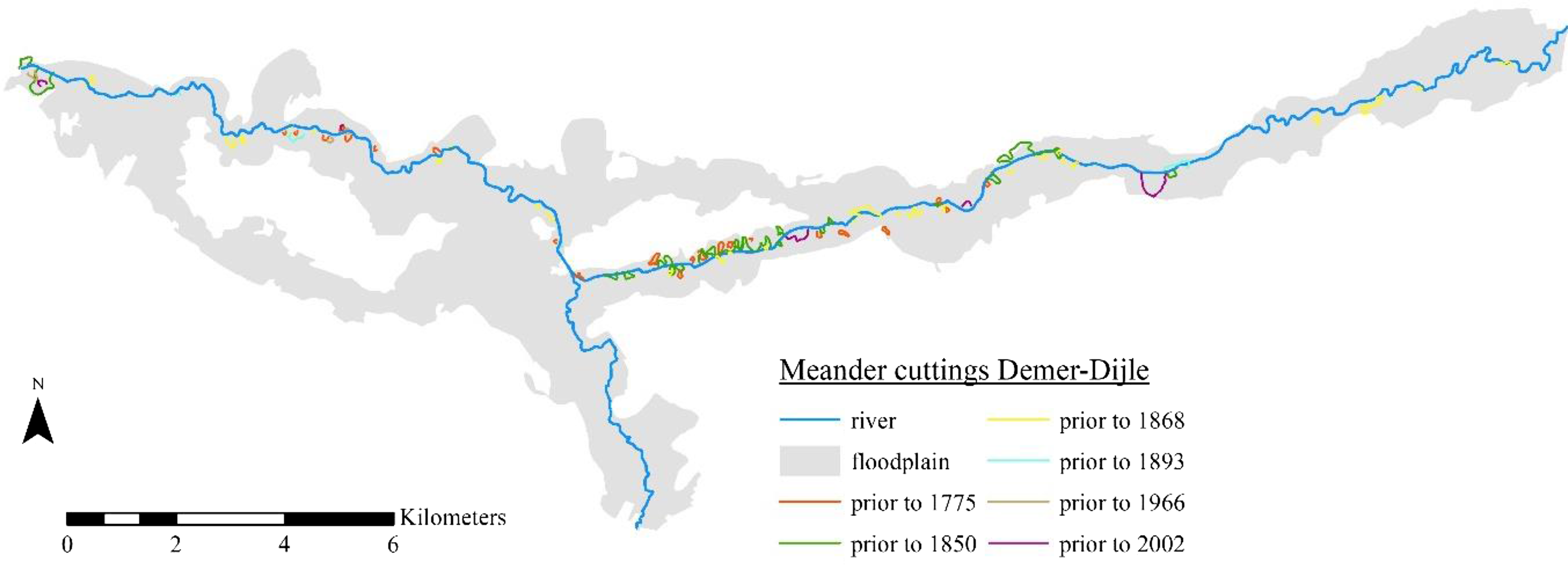
Study areas with location of regional towns and cities.

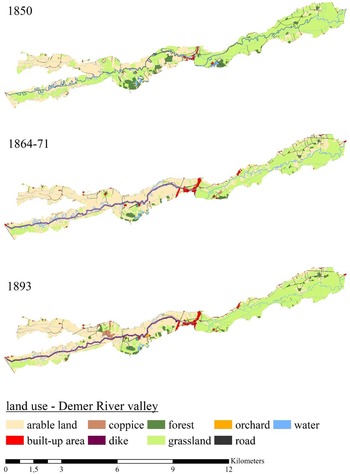
Aside from hydrological dynamics, the valley of the studied river sections and their surrounding hillslopes possess unique, biophysical characteristics (soil type, topography, etc.). As presented in Figure 1, the Demer valley is primarily dominated by clayey floodplain soils, with particularly wet grounds in its eastern half. The valley borders the sandy Campine region (in the north) and the loam-dominated Hageland Hills region in (the south). The Dijle valley in turn has silt loam to loamy soils on wide elevated levees around the channel, historically used for crop farming (Figure 4), with more clayey soils at a greater distance from the river channel.Footnote 27
The construction of a small weir in Werchter, in the year 1810, was the last major intervention, affecting the studied river systems. In the subsequent period (1819–1840), the Rivers Demer and Dijle were under the management of three different provinces (Antwerp, Brabant, and Limburg), while their tributaries (non-navigable) were managed by local municipalities. Such situations of shared custody, in practice, often led to disagreement on what river works to commence and else negatively affected management because available budgets were ill-spent. Due to negligence of governance and ‘incoherent administration’, time nor money was spent on what were otherwise urgently needed river works. By 1840, a then very young Belgian government (Belgium gained independence in 1830) acquired management control over the navigable parts of the Demer and Dijle rivers (between Diest and Mechelen). Aspiring an expansion of existing transport networks, including waterways, the Ministry of Public Works (°1837), specifically the Service of Waterways and Bridges (hereafter the service), was put in charge of Demer-Dijle, while the provinces supervised the management of the rivers’ non-navigable tributaries.Footnote 28
However, already long before the 1840s and the centralisation of river power, the lowland Demer and Dijle rivers suffered regular flooding. Historical accounts reveal previous efforts to alleviate flooding and recommend technical changes to the watercourses. What improvement works were actually done to a watercourse (rather than just contemplated on) can be traced using historical maps that depict dike embankments and meander cuttings. Figure 2 is an overlay, created using a Geographical Information System or simply GIS, of six historical map layers (date range: 1771–2002). For every individual map layer, we meticulously digitised the main channel of the studied rivers and all (cut off) meanders. As result, we obtain a visual representation of the historical river landscape and gain insights on its spatial changes over time, ideally to be matched with archival clues. Figure 2 proofs that the majority of meander cuttings on Demer-Dijle had already been completed prior to 1870. Note also the very high concentration of meander cuttings on the Demer, directly east of the confluence area. They were done to create a straighter river (less likely to flood, or so it was believed) and to facilitate a faster transport route. This resulted between 1850 and 1900 in a shortened Demer River, with a sinuosity decrease of 33%.Footnote 29
Historical meander cuttings along Demer-Dijle.
In the analysis below, we further uncover who contemplated on doing what (else) to the rivers Demer-Dijle in the name of flood prevention, during the second half of the nineteenth century. More concretely, we enquire by what means the service regulated river water in the studied confluence area, in the period 1840–1880, and what part flood prevention played in it – if any. In a chronological narrative whereby flood disasters (Table 1) form stepping stones in a political river regulating discourse, we zoom in on power relations between various river users and between different public authorities at national, provincial, and local level. They were each responsible for a different section of what is essentially the same river system.
Times flooding occurred in the Demer-Dijle confluence area, according to archival documentation found in the state archives of the Ministry of Public Works

Double river goals, 1840–1860
‘These rivers [Demer and Dijle], by a fatality, attached to them, seem destined to constantly be the object of complaints, of desires and of projects, always unsuccessful’.Footnote 30 Or so Chief Engineer Urban, who was appointed by a provincial committee concerned with flooding, concluded in his final report (in 1838). His recommendations to straighten the Demer River, to build two new weirs, and to raise river embankments were never realised, presumably because the province of Brabant, at the time in charge of managing its navigable rivers, had too few funds. Shortly after, the Ministry of Public Works seized management responsibility over Demer and Dijle, whereupon Chief Engineer Vifquain explained what exactly had turned the regimes of both rivers ‘more disastrous’. In an 1842 published work on navigable waterways and canals in Belgium, Vifquain wrote that the Demer River, a typical lowland river, flooded easily because of its small slope, narrowness at places, and many river bends. Due to, moreover, upstream deforestation and reclamation activities in the Demer valley, rainwater washed away sediments much faster, causing larger floods downstream. Sediments reaching the Dijle River, a lowland river characterised by ‘brusque and continuous movements’, caused river silting while fallen trees and other obstacles blocked the river.Footnote 31 The physical river condition – a fatality according to Urban – combined with extremer weather between 1840 and 1880, made it so that the otherwise beautiful Demer-Dijle confluence area was inundated more frequently.
Flooding happened in the third trimester of 1843, in 1844, and during the winters of 1845–1846. While no one was killed, floodwaters negatively affected crop yields, of which the consequences were worse in a period of food shortages (1844–1854) and to a lesser extent damaged town infrastructure and property. However, little mention was made of damage to landed property, other than farmland, in the source material used. In a letter addressed to the Minister of Public Works (timestamped 22 June 1846), Engineer Carez of the special division for Dijle and Demer commented on the misery caused by the exceptionally long duration of the 1845 winter flood. ‘It caused all sown grain to drop to the earth, while the long stay of the water, had made the soils so compact that they could not be tilled anymore at the start of this field campaign, and therefore largely remaineduncultivated’.Footnote 32 Also, a local newspaper reported on ‘incalculable damage’ of farmland by an 1846 inundation, causing crop roots to rot and harvests to fail.Footnote 33
Alongside farmers, mill tenants, and factory owners, a group much less represented in the primary source base, also suffered ‘catastrophic losses’ from flooding. The brothers Peeters, for example, who operated a mill in Zichem (on the river Demer), wrote a letter of complaint on 14 October 1844 addressed to the Minister of Public Works, explaining what caused their disadvantageous situation. Due to heavy rainfall in late spring and early summer of 1844, the brothers were ordered by the service to keep their sluice gates open for an extra 95 days to maintain a steady through-flow of water. Thereafter, however, a ministerial decree enforced upon the mill tenants another 40 days of open sluice gates because of river works being executed on the Demer channel. Those extraordinary water regulation measures, imposed by the service, made it so that the Demer water level was too low for mills to operate or even for ships to transport their cargo upriver. This deprived mill tenants like Peeters and others in their profession of an income for a long time (four and a half months!). They requested the minister for financial restitution.Footnote 34
Source material (and letters of complaint) imply that, after years of successive floods, the majority of principal river users – landowners, farmers, millers, factory owners, and skippers – were fed up with damaging floodwaters. To finally solve the flood problem and avoid big economic losses in the future, the service tasked hydraulic engineers to work out study-based solutions that were sustainable. Engineer Carez, who was mentioned earlier, took up that task for the Demer-Dijle catchment area. In his elaborate report of 22 June 1846, he first recounted the known problems brought by the physical condition of the rivers. Carez summed up what, according to him, aggravated the flood problem: there were many river bends, low slopes and hence low flow velocity, raised river beds due to siltation, embankments that were too low, and an overall lack of management.
In search of a solution, Carez did not have to start from scratch, given the availability of previous studies by Urban and Vifquain. Regarding the work of the latter, Carez again considered the option of constructing a canal lateral to the river Demer (mainly along its left bank).Footnote 35 The new canal, starting in Diest, would connect with existing transport routes and link the coalmines in the hinterland of Liège (Maas River), via the Campine area, with the maritime canal of Brussels (near the city of Vilvoorde). The canal plan was primarily meant to boost industrial development and bring economic prosperity to the area through better and quicker interregional transport. However, Vifquain argued that it could also remedy the flood problem. For a new canal (or a canalisation of the Demer itself for that matter) would significantly improve the flow of water and help drain meadows in the floodplain.Footnote 36 This scenario of a newly dug lateral canal, contrary to what Urban envisioned just six years earlier, relieved the Demer River from its function as a transport route and reduced it to a big drainage channel. Carez in turn, proposed normalisation works (river straightening, deepening, and dike elevation) that could prove useful in both – at the time still hypothetical – scenarios, owing to the indecisiveness of the government: canal or no canal.
In the first decades after the Belgian independence, the state government, in light of a rapidly developing industrial society, sought to construct or canalise important intraregional waterways.Footnote 37 The published work by Vifquain breathes that perception. Flood measures were consequently taken in the best interest of inland waterway transportation, which is exactly where the shoe pinches for the Demer-Dijle case. The more because navigation on both rivers gradually decreased over time as other, faster, and cheaper transport routes were made available. For Dijle River, this already started in the second half of the eighteenth century with the construction of a canal between Leuven and Mechelen (situated south of the river). Since the new canal was connected to the North Sea (via the Scheldt River), Leuven City remained a key transport link in maritime trade. Furthermore, the construction of a railway network took precedence, in the region, over paved roads and inland waterways. In 1837, the second railway line of the country was constructed between Mechelen and Leuven, while Leuven was in turn, in 1865, connected via rail to Aarschot and Diest (Figure 1).Footnote 38
As a result, the aspired double goal for Demer-Dijle river management, namely, navigational improvement and flood protection, gradually comes to be questioned: is it perhaps impossible to reconcile both? The service faced a choice, and while no one doubted that a canalisation would bring economic prosperity, serious doubts were voiced in parliament regarding its high cost and effectiveness in future flood management. ‘The Demer, because of the nature of the terrain it crosses over, can only in a difficult way reconcile the sufficient drainage of water with navigation, because the requirements of navigation rarely agree with measurements necessary to prevent floods’.Footnote 39 Regarding the studied areas, district representatives voiced their concerns in the Chamber of Representatives (parliament), urging the responsible minister to de-couple flood management from inland navigation.
When in February 1850 an ‘exceptionally large flood’, caused by rain and thaw of snow, inundated the floodplains of Demer and Dijle, more concern was given to flood mitigation measures, independent of navigational demands. This time around, however, attention was also given to nuisance predominantly caused by smaller tributaries of Demer and Dijle. It heralded a renewed round of planned (yet never executed) river works that focussed on the normalisation of non-navigable tributaries, ensuring a faster flow of water to the sea. The Minister of Public Works therefore established a committee of enquiry (on April 23) to investigate the causes and effects of the 1850 flooding and to remediate a similar disaster (in the future). The committee, set up to holistically approach the shared flood problem, mainly consisted of councillors representing the provinces of Antwerp, Brabant, and Limburg – since they were responsible for the management of non-navigable rivers (tributaries of the rivers Demer and Dijle). The committee, who convened fourteen times between May 1850 and January 1851, agreed to logically start their investigative work with the tributaries of the Dijle River and further work their way upstream. Prior to starting, they first made enquiries with local communities and visited sights. Local administrators were, furthermore, asked to open a register at the town halls of participating municipalities’, allowing civilians to write down what according to them caused the 1850 flood. While most registers remained empty, the council of aldermen in each community did provide the committee with a report on perceived causes and effects of the flood event, followed by suggestions on how to improve the regimes of Demer-Dijle.Footnote 40
Regarding what caused the flooding, a force of nature ‘that cannot be helped’, municipalities of the Dijle valley named the rupture of embankments along the river Dijle and overflowing tributaries that were ‘not provided with dikes’ as contributing causes (Figure 4). The municipalities surrounding Aarschot noticed that – compared with years prior – larger volumes of water simultaneously accumulated near the Demer – a situation that could have been aggravated by recent conversions of wet pasturelands to arable land. The chairman of the committee found that every municipality responded to the enquiry from his own interests. Moreover, concerning proposed solutions, what municipalities upstream wanted, namely, broadening of the river bed and embanked tributaries, seemed difficult to reconcile with grievances of localities downstream who asked for sluices to regulate field irrigation.Footnote 41 It appears that no follow-up was given to the research results of the committee, further ignoring the Demer-Dijle River and its tributaries.
From the undertone of parliamentary acts, we take away that there was little sense of urgency among government officials about management and flood prevention in the rural confluence area of Demer-Dijle. While there was certainly, empathy for the unfortunate farmers whose livelihoods were threatened by river flooding – not in the least by landowning parliamentarians – floods rarely damaged town infrastructure nor killed people. When, on the contrary, big cities (Leuven, Mechelen, and Diest) or industrialised areas (Vesdre valley) were in danger, river regulations were prioritised and as part of it: the creation of dependable flood protection systems.Footnote 42 Additionally, the built of alternative, intraregional transport routes over land and by rail made it so that navigation on Demer and Dijle was gradually abandoned, causing the rivers to lose their economic appeal. The government basically gave up on them. Meanwhile, the Ministry of Public Works prioritised larger river systems and more prestigious canalisation projects, like that of the Iron Rhine in the Campine area. Unlike the floodplains of Demer-Dijle, directly south of the Campine area, the ‘virgin land’ (read: wasteland) of the latter allowed ‘the Belgian state to project its most urgent spatial desires’ that culminated in a synergy of water and railroad networks.Footnote 43
Flooding experiments, 1860–1882
Since hydraulic engineers and appointed committees had thus far been disappointingly unsuccessful in bringing about change, Catholic politician Félix Vanden Branden de Reeth, who represented the district of Mechelen, stated the obvious in parliament, saying ‘things thus remain at a status quo’.Footnote 44 For a ten-year time span, 1850–1860, very few archival entries on flood nuisance in Demer-Dijle were found in the archives of the Ministry of Public Works. Even government correspondence and parliamentary interventions are few(er).
In the early 1860s, however, the government was again urged to action by local petitioners from the downstream Dijle communities (between Werchter and Mechelen), who demanded much-needed river regulations, promised long ago. Their reclamations came after river floods, in 1860–1861, had damaged croplands. Floodplain reconstruction research by Lathouwers et al. (2023) pointed out that, in the period 1864–1868, approximately 70% of the Dijle floodplain was covered in arable land, most of which was situated directly next to the river (on natural levees) (Figure 4). Arable lands, also in the river valleys, had in recent decades expanded to meet a growing demand for food, caused by a demographic increase and profit from higher prices. It adds up that large landowners of the Dijle floodplain were the first to complain (to the local alderman or directly to the Minister of Public Works), when water overflowed the riverbank, threatening agricultural production and interests. They furthermore, in their petition and letters of complaint, signalled a new problem. During the previous twenty years, multiple river bends had been cut off along the Demer River (Figure 2), which sped up the through-flow of river water so significantly, to the point where downstream communities along the Dijle suffered more flooding.Footnote 45 The floods of December 1862 and January 1863, for example, resulted in real calamities. It was wrong to just cut off Demer meanders without broadening and deepening the river channel itself, as Vanden Branden de Reeth, among others, argued because it only ‘moves the evil’.Footnote 46 It was thus in everyone’s best interest to start work downstream and strive for a coordinated river management.
Where farmers of the Dijle valley complained about too much water, large landowners in the Demer valley, often of important social standings, required more river water to timely fertilise their wet pasturelands (Figure 3). Representing the latter group was Pierre Van den Eynde who, residing in Aarschot (city on the Demer), regularly took a stance in the Chamber of Representatives. Together with fellow landowners (Beeckman, Smolders, and Wouters), he campaigned against the law of 1845 and, in general, against the service’s rectification policy. The law of 1845 stipulated that four river weirs on the Demer needed to be kept open during the winter months (November until March), as to ensure a continuously high enough water level for shipping. Those weir mechanisms (with sluice gates), however, in combination with a shortened river (stripped of its meanders), caused the Demer to discharge its water quicker, which in turn messed up the natural flood regime and hindered field irrigation in wintertime. Regulations in other words limited the number of occasions the Demer could flood, meanwhile depositing nutrient-rich sediment materials on wet pasturelands. As a result, hay yields decreased, and owners like Van den Eynde lost revenues.Footnote 47
Digital reconstruction (in GIS) of historical land use in the Demer valley (1850–1893).

From 1 June 1874, new regulations on river weir management came into effect (and thereby replaced the law of 1845), but local landowners and district representatives Beeckman, Smolders, and Wouters were by no means impressed. According to them, the new regulations did not worry over agricultural demands but instead, favoured shipping ‘that had been zero since a few years’, and did not worry over agricultural demands.Footnote 48 However, after some insistence, the service granted permission to the landowners (via a ministerial decree of 13 March 1876) to, only during wintertime, close the river weir in Aarschot. As a result, floods could be artificially generated on the Demer River.Footnote 49 Worried that the artificial flooding would expose arable lands to a higher risk, the service, advised by Engineer Carez, stopped the experiment after several years. Other river users, by the way, also felt disadvantaged. A letter sent on 13 February 1878, addressed to the minister, testifies how experimental flooding practices downstream (in Aarschot) negatively affected milling activity in Diest where the weir remained closed. The mill tenants consequently plead to command the opening of all river weirs, which would assure a regular through-flow of water. Alternatively, the service would have to be reasonable and grant all millers the same privilege of closing their sluices at high water.Footnote 50
While the ad hoc manoeuvring of the sluices of river weirs, at the will of the service, may have averted some inundations, it also plagued mill tenants and others who owned economic enterprises on the river (using its water for power). The latter group that welcomed high water but feared floods (like most) was in the parliament out rightly accused of disobeying or bending the rules concerning the maximum allowed water level during normal times. Jean Thonissen, a member of the parliamentary finance committee, stated in parliament, based on enquiries he had made with riparian landowners, that ‘millers mocked the regulations’ and thus ‘largely contributed to causing floods and making them last longer’.Footnote 51 Employees of the service closely monitored the water level at all four weirs on the Demer River so that they could, par mesure de prudence (as a precaution), timely instruct their opening in case of high water. That could however not prevent flooding in the years 1879 (January 6–8), 1880 (January), and 1882 (July 27 and September 20–24). The 1882 flood disasters were caused by heavy rainfall and local thunderstorms. When in the wake of such adversaries, government officials got the blame for allegedly ill-operating river weirs; however, the service from their side would generally refute such accusations.Footnote 52
Meanwhile, in parliament, representatives of the people again expressed their concern about serial floods, especially on behalf of farmers, which had become more unpredictable – partly due to past rectifications enabling a faster discharge of large(r) volumes of water. There was a certain contemporary awareness of the negative effects of river rectifications, as experienced by pastureland farmers, but meander cutting as an effective river regulating method was never second-guessed in parliament itself.
‘The unfortunate who have already suffered so much’
In a letter (timestamped 19 September 1881), the then provincial councillor of Brabant, Albert Moericnkx, suggested ideas to the provincial Governor of Brabant, of which some could be useful to ‘the unfortunate who have already suffered so much from the floods’. With the unfortunate, he mainly had the agricultural population in mind. They were, in addition to regular flood adversities, in the late nineteenth century confronted with low food prices due to the import of cheap (bread) cereals from the USA, Canada, Ukraine, and Russia.Footnote 53 Aside from broadening the Dijle River, Moerinckx therefore proposed to move the dikes 50–60 m away from the main watercourse, instead of elevating them. Consequently, when the river did overflow its banks, it would theoretically have more room to do so freely, without damaging the immediate surroundings (safe behind dikes). Furthermore, Moerinckx had an economic motive (Figure 4). Since this strip of grassland between river and dike would occasionally flood with sediment-rich water from the river, he reasoned that it would yield more as pastureland (or at the bare minimum as fodder for cattle).Footnote 54 Although the report did not lead to further action, it is noteworthy that the ideas proposed cater to the needs of livestock farming, which became more important in response to cheap grain imports (beginning in the 1880s).
Digital reconstruction (in GIS) of historical land use in the Dijle valley (1850–1893).

Provincial councillor Moerinckx was far from the first who witnessed his plan fall through. Also written testimonials from river users or recommendations made by municipal councils, addressing cause and effect, were largely done in vain. By 1883, zero money had been spent on Demer-Dijle, while no structural improvement works had been commissioned in the last decade. The matter left Jean Thonissen, member of the parliamentary finance committee, to conclude in April 1883 that ‘the government has not done what it was supposed to do’.Footnote 55
One year later, the Ministry of Public Works was dissolved, whereupon the service’s power was transferred to a newly formed Ministry of Agriculture, Industry, and Public Works (°1884). It was the first ministry in Belgium, dedicated to the development of agriculture, implying that the government was ready to address farmers’ issues - such as low grain prices due to an oversupply of overseas grain - more seriously. Agriculture in the Demer and Dijle valley was still plagued by too much water or, depending on whom you would ask, too little (wet pasturelands in wintertime). The new ministry called for the formation of local water boards (in Dutch: Wateringen) because they would greatly assist in ‘the improvement and maintenance of watercourses’.Footnote 56 Or was it perhaps a way for the government to apportion responsibility? A watering is a public association of local riparian landowners/land users, who maintain a favourable water management system within their circumscription for reasons to do with agriculture and, to a lesser extent, sanitation. Similar water associations existed, be it under a different name and with other house rules, in multiple European countries, and formed an important link in nineteenth-century wetland reclamation.Footnote 57
In 1884, sub-engineer Gevaert wrote that a watering in the Demer valley would have to focus on drainage rather than irrigation, which was the custom in many other Belgian river valleys (e.g. Lys valley) at the time. While Gevaert proposed works that would avoid summer floods, laterally dug canals discharging water would still allow for controlled winter inundations (fertilising wet pasturelands). Much to the incomprehension of the service, however, riparian landowners in the eastern part of the Demer valley (Diest-Aarschot) were reluctant to unite in a watering because of, in their own words, the large ‘fragmentation of pastures’ (Figure 3). Debates on the usefulness of a local water association just for the Demer valley (from Diest to Aarschot) were rehashed in the interbellum and ultimately led to the foundation of a watering in 1938.Footnote 58
With the Ministry of Agriculture, Industry, and Public Works overseeing the navigable Demer-Dijle River, traffic on both rivers had become very minimal; flood management was predominantly approached from an agricultural point of view. Like in previous decades, however, the fragmentation of powers (to make policy), divided among the ministry (navigable) and the provinces and municipalities (non-navigable), plus water boards if the ministry had its way, led to uncoordinated actions. And although everyone principally subscribed to the downstream–upstream direction of contracting river works, in practice, one did not act accordingly. To illustrate this, the parliamentary session of 20 February 1884 is telling. Therein Jean Thonissen takes the stand, as he demands parliament to acknowledge for one moment the ‘considerable damages’ suffered in the province of Limburg, due to an ‘insufficient flow’ of Demer river water. A fellow parliamentarian critically counters the request reminding everyone that the central government only has the power to manage the navigable part of the Demer River (which is downstream of Diest, in the province of Brabant). Thonissen continued: Since Belgian army engineers had put in place a new, but fixed river weir in Diest, too high according to Thonissen, croplands and pasturelands upstream of Diest frequently inundated. Prior to his interpellation, Thonissen consulted the Governor of Brabant and the service’s administration, both of whom stated that works between Diest and Aarschot had to be done first. The same works for which a budget was set aside in 1881, which still had not been commissioned in 1884. Thonissen sadly concluded that ‘part of Limburg was inundated to prevent inundations in Brabant’.Footnote 59
Conclusions
Historians have described nineteenth-century river regulations as a step-by-step process orchestrated by centralising nation states that, in general, had two objectives: flood prevention and management. Therefore, ‘linear catchment-wide comprehensive projects’ were worked out by hydraulic engineers, operating in the name of the state while usually clustered in a governmental department of ‘Public Works’ or the like.Footnote 60 Impressive examples are the Wien River, the German Rhine wherefore Engineer Tulla had big dreams, and the systematic normalisation of the Dutch Waal. The Demer-Dijle River – outdated as a transport route by roughly 1880 – was no match when compared in size, while its transformation resembled ‘a patchwork of hydraulic interventions’.Footnote 61 However, the rectification of both studied rivers were no less dramatic, and the road to it was bumpy, especially during a period of socio-economic turmoil and industrialisation (late nineteenth century). A series of river improvement plans were drawn up wherefrom a handful were executed, resulting in a suboptimal solution, while the majority remained largely unnoticed because Demer-Dijle was simply no priority.
Flooding was nonetheless a lingering problem that instilled fear and was passed through generations. Also in the period 1840–1880, governmental (re)action was wanted. Flood prevention was an issue important for the state’s special river engineers who were tasked to solve that historical problem but also for the lower echelons of government (provinces, cities, and municipalities and local water boards/river associations) and finitely for all principal river users. In nineteenth-century Germany, under the spell of a nature conquering discourse, flood protection schemes co-motivated hydraulic engineering.Footnote 62 Also, the Dutch Rijkswaterstaat switched to a heightened state of alertness whenever floodwaters breached dikes and submerged inhabited or cultivated land.Footnote 63 For the studied confluence area, floods created a window of opportunity, a moment seized by people’s representatives to directly confront the minister, in parliament, with the faith of those unfortunate. Compelling about the Demer-Dijle case too is that new flood problems were created, caused by river regulations: the river flooded elsewhere (out of season) or its tributaries overflowed instead. A similar story was recorded for the German Eider River, where the placement of a flood defence system (including dikes) resulted in more catastrophic flooding.Footnote 64
Alleviating flooding (and managing rivers altogether) in a coherent and efficient manner was no sinecure because scientific knowledge was limited, communication was slow, and policy was fragmented – centralisation efforts of the Ministry of Public Works in spite. With navigable and non-navigable river stretches being managed by, respectively, a ministerial department and three provinces, alongside municipalities in charge of the smallest river branches, coordinating upstream river works with downstream ones proved challenging. Moreover, and this is especially true in times of stress (e.g. high water), parliamentarians spoke up for river users from their constituency and, when push came to shove, defended their own interests (e.g. as large landowners). Another recurring theme in parliamentary negotiations was money, and more precisely issues revolving around who is going to pay for what – that is, if there was any budget to start with. Further research, consulting government finances at various levels, can paint a more comprehensive picture of funds allocated to the Demer-Dijle River, in relation to money simultaneously spent on other watercourses.
Today, Belgian river governance is still a highly fragmented policy field, whereby several public authorities are involved, on different levels of power (e.g. national, regional, provincial, local). The regionalisation of water management, following state reforms in the 1980s, further complicated policy relations and was far from conducive to better coordination between upstream and downstream areas.Footnote 65 That is problematic considering we are, today, more frequently faced with the effects of climate change whereby hot and dry summers pass onto long(er) periods of drought and extreme rainfall culminates in flooding. In Flanders where different rivers (big and small) flooded in November 2023 and in January–May 2024, experts and politicians have begun to re-think (once more) the organisation of river management, seeking also to reduce the number of actors involved.Footnote 66 While the constellation and objectives of public water authorities have changed since the nineteenth century, alongside visions on river management, the need for better coordination and cooperation in river management, this research proves, remains constant – especially in times of crisis.
Competing interests
The author(s) declare none.


 Open access