


Beginning in the Middle Holocene, central Nevada foraging communities moved into their upland desert-mountain mosaic, developing subsistence and cosmological practices that persisted—with some significant challenges and transformations considered here—into the ethnohistoric era. Thomas (Reference Thomas2023) chronicled this lifestyle in detail, and we summarize the essential elements.
Central Great Basin foragers mapped onto the verticality of their desert-mountain resource base—patchy in time and space—by moving themselves to resources (as opposed to marsh-tethered lacustrine strategies that transported resources to people), with an intrinsic resilience capable of adjusting group size and composition (Simms Reference Simms2008:32–37). Rarely settling in the semipermanent villages more typical of lacustrine settings, desert-mountain foragers sometimes stayed for months in winter villages located in the piñon-juniper belt, set up camps near lowland fish-driving spots, and often spent weeks at summertime root-collecting places on the valley floors. They periodically aggregated at special-event super-camps to stage pronghorn and jackrabbit drives, with the associated fandangos strengthening kinship ties, regional identities, and resource-specific communication (Thomas Reference Thomas and Fowler1972).
These foragers engineered the desert-mountain landscapes from top to bottom. Alpine hunters set up thousands of blinds, rock drift fences, and soldier cairns to help channel large game into harm's way. They embellished rock features to mimic fake hunters and pulled up small slabs to corral sage grouse as they mated. Hunters sometimes temporarily left their families to go on alpine expeditions that were staged from logistic camps, the earliest identified at Gatecliff Shelter (6170–6060 cal BP; Thomas Reference Thomas1983). They crafted man caves as redundant personal spaces, building small fire hearths to heat sleeping areas near the cave walls. They carried field-dressed bighorn sheep into these naturally protected spaces to dry meat for transport and lighten the load. Eight similar man cave campsites were stacked vertically inside Gatecliff Shelter, spanning more than three millennia. Indigenous communities also fashioned lowland pronghorn traps across the Great Basin, reusing and refurbishing these facilities for millennia (Hockett and Dillingham Reference Hockett and Dillingham2023; Hockett et al. Reference Hockett, Goebel, Graf and Stoner2023; Thomas Reference Thomas2023:Chapter 8). Thousands of Northern Side-notched and Gatecliff projectile points still litter the alpine and subalpine catchments of the central Great Basin—mute testimony to the intensity of the high-elevation hunting that began in the Middle Holocene.
Central Mountain Archaic communities experienced millennia of exponential growth, with their population growing more rapidly as it increased in size (Robinson and Thomas Reference Robinson and Thomas2023). This lifeway was severely challenged 3100 cal BP by the Late Holocene Dry Period (LHDP), the most severe megadrought of the last 6,000 years. What happened to the people in its path?
Extreme Climate and Cultural Shifts
Archaeologists have long pondered the cultural impacts of natural catastrophic events such as earthquakes, volcanic eruptions, severe droughts, abrupt cooling episodes, changing sea levels, and epidemics. With the contemporary realities of abrupt climate change increasingly apparent, “collapsology” (Middleton Reference Middleton2017:82) came to dominate academic and popular discourse within archaeology, television documentaries, feature films, and novels—highlighted by the 2004 blockbuster movie The Day after Tomorrow and the nonfiction bestseller Collapse: How Societies Choose to Fail or Survive (Diamond Reference Diamond2005).
Despite the obvious appeals of “collapse archaeology” (Butzer and Endfield Reference Butzer and Endfield2012), many have become impatient with simplistic tales of past societies overexploiting and overshooting the limitations of their ecosystems, leading to internal and external stresses followed by transformation or outright collapse (Løvschal Reference Løvshal2022:197; McAnany and Yoffee Reference McAnany and Yoffee2010; Olsson et al. Reference Olsson, Jerneck, Thorén, Persson and O'Byrne2015). Hypotheses directly connecting social “collapses” to abrupt climate change suffer from broadly dated paleoclimatic proxies with uncertain effects on society: such disconnects make it difficult to define causal linkages between human societies and the “megadisturbances” they experience (Kohler and Rockman Reference Kohler and Rockman2020; Millar and Stephenson Reference Millar and Stephenson2015). Kintigh and Ingram (Reference Kintigh and Scott2018) statistically assessed and questioned the correspondence between episodes of extreme climate (such as droughts) and cultural events (such as depopulation) that they purported to explain (see also Degroot et al. Reference Degroot, Anchukaitis, Bauch, Burnham, Carnegy, Cui and de Luna2021). Although climate extremes have long been implicated in large-scale cultural transformations, rarely are they the sole cause (Kennett et al. Reference Kennett, Breitenbach, Aquino, Asmerom, Awe, Baldini and Bartlein2012). In some cases, unexpected and nonlinear relationships connect climate change and human behavior (Kennett Reference Kennett2005; Kennett and Kennett Reference Kennett and Kennett2000).
Impacts of the Late Holocene Dry Period (LHDP)
Reflecting O'Brien's (Reference O'Brien, Cunningham and Driessen2017:295) “boredom with the apocalypse,” we applaud the search for pathways through which external perturbations are mediated by social variables, including subsistence strategies, settlement patterns/mobility, population density, territoriality, infrastructure, technology, and previous experience (Fitzhugh et al. Reference Fitzhugh, Butler, Bovy and Etnier2019; Mulholland Reference Mulholland2021; Nelson et al. Reference Nelson, Ingram, Dugmore, Streeter, Peeples, McGovern and Hegmon2016). Most collapsology addresses large-scale agricultural societies, and we think it appropriate to explore abrupt climate change impacts on smaller-scale mobile communities.
The LHDP was a one-plus millennial megadrought (3100–1800 cal BP) across the southwestern United States (Mensing et al. Reference Mensing, Sharpe, Tunno, Sada, Thomas, Starratt and Smith2013). This dry interval is evident in pollen records from eastern to northwestern Nevada (Mensing et al. Reference Mensing, Smith, Norman and Allan2008, Reference Mensing, Sharpe, Tunno, Sada, Thomas, Starratt and Smith2013, Reference Mensing, Wang, Rhode, Kennett, Csank, Thomas and Briem2023), limber pine (Pinus flexilis) dendroclimatology and population histories in the Wassuk Range (Millar et al. Reference Millar, Charlet, Westfall, King, Delany, Flint and Flint2018), reduced growth in other limber pine dendrochronologies across the Great Basin (Millar et al. Reference Millar, Delany, King and Westfall2021), and other records (e.g., Theissen et al. Reference Theissen, Hickson, Brundrett, Horns and Lachniet2019). The LHDP varied in geographic range, duration, and intensity across the Intermountain West. Late Holocene paleoenvironmental chronologies suggest that the LHDP followed a persistent dipole pattern, with wet sites to the north and dry sites to the south (Mensing et al. Reference Mensing, Sharpe, Tunno, Sada, Thomas, Starratt and Smith2013, Reference Mensing, Wang, Rhode, Kennett, Csank, Thomas and Briem2023). Correlative drought-related shifts in occupation patterns are evident in archaeological sites, including Gatecliff Shelter (Kennett et al. Reference Kennett, Culleton, Dexter, Mensing and Thomas2014; Thomas Reference Thomas1983), Alta Toquima (Thomas Reference Thomas2020), Bonneville Estates Rockshelter (Goebel et al. Reference Goebel, Hockett, Rhode and Graf2021), and O'Malley Rockshelter (Fowler et al. Reference Fowler, Madsen and Hattori1973).
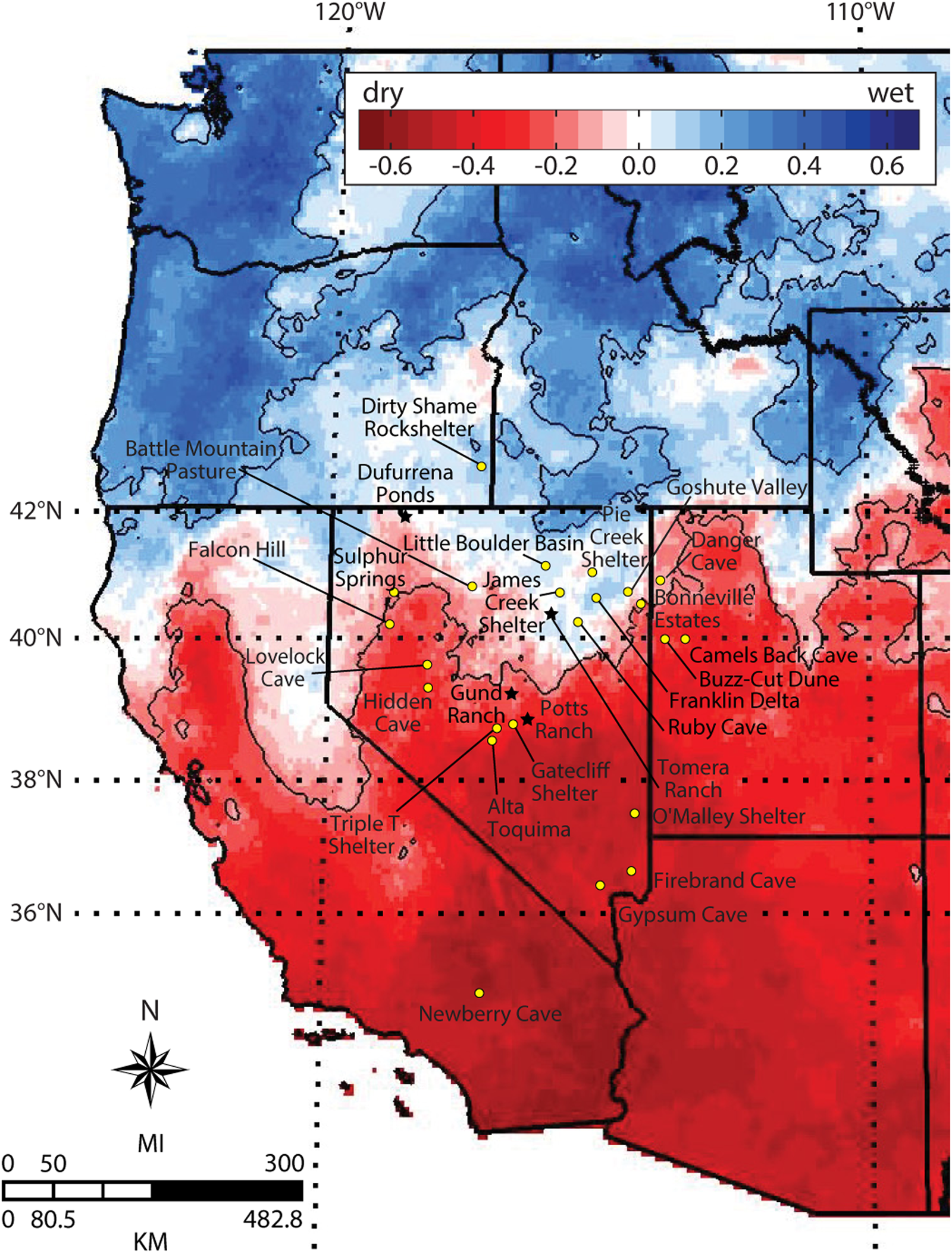
In this companion article to Mensing and colleagues (Reference Mensing, Wang, Rhode, Kennett, Csank, Thomas and Briem2023), we report the first systematic test of the LHDP hypothesis in a cultural context. Beginning in 2016, our interdisciplinary team pursued paleoecological and archaeological studies in Nevada along a north–south transect between 39° N and 42° N latitude, designed to span the dipole pattern of El Niño / Southern Oscillation (ENSO)–associated precipitation (Figure 1). Paleoecological results confirm previous assessments and partition the LHDP into three phases: an initial 900-year dry period, 200 years of wetter climate, and two final centuries of extreme drought. New pollen and radiocarbon evidence from four wet-meadow sites (presented in Mensing et al. Reference Mensing, Wang, Rhode, Kennett, Csank, Thomas and Briem2023) demonstrates a sedimentation hiatus (or significant slowdown) during the period about 2000–1800 cal BP, interpreted as a severe drought signal across the central Great Basin. The geographical extent of the LHDP remained stable between 39o N and 40o N latitude, which is similar to the latitude boundary of the ENSO dipole (Wise Reference Wise2010), with sites to the north remaining wet and dry climate prevailing in the south. At its maximum (2000–1800 cal BP), the LHDP was the driest Great Basin climate of the last 6,000 years, its severity and duration more extreme than the well-documented megadroughts of the Medieval Climatic Anomaly (Stine Reference Stine1994). The extreme and extended aridity of the LHDP south of 40° N latitude is explained via ENSO processes (Mensing et al. Reference Mensing, Sharpe, Tunno, Sada, Thomas, Starratt and Smith2013, Reference Mensing, Wang, Rhode, Kennett, Csank, Thomas and Briem2023), particularly a long-lasting La Niña state. Such La Niña oceanic conditions are associated with dry climates in the American Southwest and with wetter conditions in mid-latitudes farther north, though anomalously wet La Niña phase winters can also occur in northern California / Great Basin; for example, in 2022 and 2023 (Guirguis et al. Reference Guirguis, Gershunov and Cayan2015). Notably, documentation of such droughts came primarily from low-elevation sites, with few conclusions about mountain conditions.
Map of correlation coefficients between June to November Southern Oscillation Index (SOI) and October through March precipitation (1892–2007) showing the north–south antiphasing dipole pattern of precipitation associated with ENSO (adapted from Wise Reference Wise2010, with permission). Black stars represent paleoenvironmental sites; circles represent archaeological sites.
We expand the synthesis by Mensing and colleagues (Reference Mensing, Wang, Rhode, Kennett, Csank, Thomas and Briem2023) with new archaeological results detailing the diverse cultural responses to these regionally differentiated impacts. Collapsology fails to capture the pivotal importance of human agency: the ability of individuals to act freely and make their own choices. To do this, we draw instead on “survivance,” a concept developed by Anishinaabe scholar Gerald Vizenor (Reference Vizenor1998:15): “Survivance [is] more than survival, more than endurance or mere response; the stories of survivance are an active . . . repudiation of dominance, tragedy, and victimry.” So viewed, survival is about getting through the present in a hurry, without much thought for the future. Survivance is survival with attitude, combining endurance, resistance, and planning ahead. The survivance concept embraces agency rather than passivity, harnessing aggressive ways beyond merely staying alive but also flourishing in the future (Silliman Reference Silliman, Ferris, Harrison and Wilcox2014; Wieskamp and Smith Reference Wieskamp and Smith2020:72)
Combined with insights from resilience theory and behavioral ecology, survivance helps contextualize the broad-scale adjustments and decisions made by affected Indigenous communities, which reflect cultural attachments to landscapes and ancestral places under duress (see also Fitzhugh et al. Reference Fitzhugh, Butler, Bovy and Etnier2019; Riris and de Souza Reference Riris and de Souza2021; Scheffer et al. Reference Scheffer, van Nes, Bird, Kyle Bocinsky and Kohler2021). We marshal new evidence regarding high-elevation Great Basin climates and explore likely impacts of simultaneous Neoglacial advances throughout the LHDP and beyond—a perspective not previously incorporated in LHDP studies. We propose that these insights help understand survivance to the challenges and possible windfalls of the LHDP across the Great Basin's altitudinal range.
New Archaeological Evidence
High-precision chronologies from Gatecliff Shelter and Alta Toquima (Kennett et al. Reference Kennett, Culleton, Dexter, Mensing and Thomas2014, Reference Kennett, Culleton, Harper, Thomas and Thomas2020:401–410) anchor the southern end of our north–south transect (Mensing et al. Reference Mensing, Wang, Rhode, Kennett, Csank, Thomas and Briem2023:Figure 9). To further historicize human responses, we redated James Creek Shelter (Elston and Budy Reference Elston and Budy1990) and Pie Creek Shelter (McGuire et al. Reference McGuire, Delacorte and Carpenter2004), both located toward the northern end of the dipole transect (Figure 1). We processed 18 new AMS radiocarbon dates from previously undated plant remains in key stratigraphic sections (Supplemental Table 1) and developed Bayesian chronological sequences for both sites (Supplemental Texts 1 and 2), with model results yielding good agreement indices.
We conclude that James Creek Shelter was occupied episodically during the LHDP, documented in a cluster between about 2725–2400 cal BP, followed by a gap lasting around 250 years, followed by another cluster about 2105–1890 cal BP, with additional occupation episodes at about 1570 and 1355 cal BP. The newly dated sequence for Pie Creek Shelter generates two possible scenarios for LHDP occupations, depending on the age of a major rock fall event. If Rock Fall I occurred about 2300 cal BP, it likely rendered Pie Creek Shelter effectively uninhabitable until around 1,500 years ago. Alternatively, if the rock fall happened about 1,500 years ago (McGuire et al. Reference McGuire, Delacorte and Carpenter2004), the LHDP represents a long interval of sparse and sporadic occupation from around 2400–1500 cal BP. Under this scenario, the negligible use of Pie Creek Shelter might be attributable to LHDP effects, despite its northerly location. We do not know which scenario is correct but suspect that Pie Creek Shelter provided a well-watered northerly refuge during the LHDP until Rock Fall I cut short its habitability.
Figure 2 plots these new results against five well-dated Great Basin archaeological sites. Grading from north to south across the 42°–40° N dipole, these combined findings demonstrate that sites north of the dipole remained occupied for much of the LHDP, whereas significant disruptions were common south of the dipole. A notable exception is Alta Toquima, which demonstrates the reverse pattern, with significant high-elevation human occupations in the face of extreme lowland drought.
Summed probability distribution of the available 14C dates from five archaeological sites in the Great Basin distributed from north to south (top to bottom) across the 42°–40° N latitude dipole as a proxy for occupation intensity: Pie Creek Shelter (41.3° N lat), James Creek Shelter (40.8° N lat), Gatecliff Shelter (39.0° N lat), Alta Toquima (38.8° N lat), and O'Malley Shelter (37.5° N lat). The LHDP is shown with gray shading between 3100 and 1800 cal BP with the dark-gray P (pluvial) indicating a wetter period of the LHDP and the D indicating the driest part of the LHDP. Sites north of the dipole remained occupied for much of the LHDP; significant disruptions in occupation occurred at some sites south of the dipole. Other sites south of the dipole remained occupied and demonstrated resilient foraging adaptations in the face of drought (after Mensing et al. Reference Mensing, Wang, Rhode, Kennett, Csank, Thomas and Briem2023:Figure 9).

Confronting LHDP Neoglaciation
New evidence regarding high-elevation Great Basin climates helps explain these behavioral responses. Prior ecological studies (Mensing et al. Reference Mensing, Smith, Norman and Allan2008, Reference Mensing, Sharpe, Tunno, Sada, Thomas, Starratt and Smith2013, Reference Mensing, Wang, Rhode, Kennett, Csank, Thomas and Briem2023; Millar et al. Reference Millar, Delany, King and Westfall2021; Miller et al. Reference Miller, Germanoski, Waltman, Tausch and Chambers2001; Tausch et al. Reference Tausch, Nowak, Mensing, Chambers and Miller2004) focused on the multiple proxies demonstrating the varied effects of the prolonged drought during the LHDP. But the role of temperature in modulating or exacerbating those effects is poorly understood, particularly in different LHDP phases (Mensing et al. Reference Mensing, Smith, Norman and Allan2008:87, Reference Mensing, Sharpe, Tunno, Sada, Thomas, Starratt and Smith2013:277). The substantial literature on Great Basin Neoglaciation has yet to be comprehensively incorporated into studies addressing mountain climatic conditions during the LHDP, and this evidence provides important insights on responses of Great Basin communities to LHDP impacts.
Millar and Thomas (Reference Millar and Thomas2023) directly tackle early Neoglaciation in the Great Basin—what they term the “800-pound gorilla in the room”—by documenting its extent, timing, and implications for high-elevation temperature and precipitation. Neoglaciation (NG) is defined as a worldwide geoclimatic (time- and space-transgressive) unit characterized by the rebirth and growth of alpine glaciers following their maximum shrinkage during the warm, dry Middle Holocene (Porter and Denton Reference Porter and Denton1967). Broadly, Porter and Denton (Reference Porter and Denton1967) recognized the NG as extending from 4,000 to 5,000 years ago to the early twentieth century, with dates and duration varying by latitude and region. Despite variability, glacial advances across global alpine regions clustered into two major periods, the “early NG” extending from about 3,500–4,000 to about 1,600 years ago and the “late NG,” widely recognized as the Matthes advance or Little Ice Age (LIA; Grove Reference Grove1988) dating about 700 years ago to the early 1900s AD. An approximately 900-year interval of no or mild/short glacial advances is commonly documented between these bookends.
Dating Early Neoglacial Advances in the Great Basin
Before the mid- to late 1980s, glacial geologists in the Great Basin assumed that the Neoglacial was restricted to the recent LIA interval, without earlier advances. This conclusion resulted from the absence of moraines typical of ice glacier deposits that dated older than the LIA in mountains of the Great Basin (Clark and Gillespie Reference Clark and Gillespie1997; Munroe Reference Munroe2002). Increasing recognition of the role of rock glaciers (Barsch Reference Barsch1996; Martin and Whalley Reference Martin and Whalley1987) triggered a reevaluation of early NG advances in the Great Basin. Although rock glaciers had been described in the Great Basin (Osborn and Bevis Reference Osborn and Bevis2001)—especially in the Sierra Nevada (Millar and Westfall Reference Millar and Westfall2008), the Snake Range (Davis Reference Davis1988), and the Uinta Range (Munroe Reference Munroe, Bigl, Silverman, Laabs, Starratt and Rosen2005)—no systematic inventory or assessment was available until Millar and Westfall (Reference Millar and Westfall2019) documented the widespread distribution of Late Holocene-age rock glaciers throughout high mountains of the Great Basin. Analyses of sediment cores taken from high-elevation cirque lakes provided secure dates for early NG advances in the western and eastern Great Basin (Bowerman and Clark Reference Bowerman and Clark2011; Munroe Reference Munroe2002). The upshot is that the early Neoglacial is now recognized as a period of prominent glacial advance widely expressed throughout western North America (Davis et al. Reference Davis, Menounos and Osborn2009), with dates extending through most of the LHDP. The analysis of locations and ages developed in Millar and Thomas (Reference Millar and Thomas2023) is summarized next.
The most accurately dated glacial advances in the Great Basin (GB) derive from the central and southern Sierra Nevada in California, the Ruby Mountains and East Humboldt Range in Nevada, and the Uinta Mountains in Utah (Figure 3). These studies define early NG advances as early as 3800–3700 cal BP, with multiple subsequent advances estimated (Bowerman and Clark Reference Bowerman and Clark2011; Clark and Gillespie Reference Clark and Gillespie1997; Konrad and Clark Reference Konrad and Clark1998; Munroe Reference Munroe2002, Reference Munroe, Dehler, Pederson, Sprinkel and Kowallis2005; Munroe et al. Reference Munroe, Klem and Bigl2013, Reference Munroe, Bigl, Silverman, Laabs, Starratt and Rosen2018; Reinemann et al. Reference Reinemann, Porinchu, Bloom and Mark2009), documenting that the Neoglaciation persisted throughout the entire LHDP.
Map of Great Basin mountain ranges showing evidence for early Neoglaciation. Blue labels are ranges where published records document early Neoglacial advances. Green labels are additional ranges assessed by Millar and Thomas (Reference Millar and Thomas2023) from the rock-glacier inventory of Millar and Westfall (Reference Millar and Westfall2019) to have had early Neoglacial advances. Base map modified from Esri, USGS, and NOAA.

New evidence from a GB-wide inventory of rock glaciers and persistent ice fields (Millar and Westfall Reference Millar and Westfall2019), combined with published studies, documents early NG expression in 33 Great Basin ranges extending from 36.5° N to 44.3° N and from 110.7° W to 121.4° W (Figure 3; Millar and Thomas Reference Millar and Thomas2023). The implication is that all high mountain regions of the “cold GB”—excluding southern desert ranges and a few high ranges without early NG evidence—likely experienced early NG glacial advances without any apparent latitudinal dipole.
Most published studies on Neoglacial temperature and precipitation thresholds in the GB focus on conditions under which ice glaciers grow. Synthesizing previous thermal relations of GB rock glaciers with new estimates from the rock-glacier inventory, Millar and Thomas (Reference Millar and Thomas2023) estimate high-elevation climatic conditions for early NG advances in several ranges, including the Toiyabe Range. Winter precipitation and summer temperature threshold values are critical for glaciers to grow, and various combinations of cool summers and wet winters allow rock glacial development. For temperature/precipitation combinations feasible for LHDP aridity at low elevations, rock-glacier growth in the early Neoglacial high Toquima Range cirques would require a summer temperature depression of about 1.3°C to about 4.3°C.
Neoglacial Impacts during the LHDP
Millar and Thomas (Reference Millar and Thomas2023)—recognizing that the LHDP was an extreme and long period of aridity south of 40–42° N latitude (Mensing et al. Reference Mensing, Wang, Rhode, Kennett, Csank, Thomas and Briem2023)—concluded that summer temperature depressions in the range noted earlier could enable rock glaciers to grow. Although it might seem surprising that glaciers would develop with decreased precipitation, Plummer (Reference Plummer2002) developed water-balance models to explain precipitation–temperature relationships between glacier growth in the Sierra Nevada uplands and water relations—using Owens Lake level as a proxy—in the lowlands. With temperature depressions in the range of about 1°C–4°C, rock glaciers would have been capable of growing during the LHDP even with decreased precipitation (Plummer and Phillips Reference Plummer and Phillips2003).
Cooler summers and slight increases in winter precipitation, as suggested by the growth of rock glaciers, would have sustained GB mountain ecosystems in vibrant, healthy condition. Drainage from ice-embedded rock glaciers would not lead to significant downstream flow; instead, water from these features would be retained in the uplands with abundant glacier-fringed springs (Brighenti et al. Reference Brighenti, Hotaling, Finn, Fountain, Hayashi, Herbst, Saros, Tronstad and Millar2021). Cool temperatures in the uplands would reduce evaporation, enhance soil moisture, and reduce the transpiration/water needs of plants. Thus, conditions at alpine elevations likely supported diverse and healthy plant growth, distributed springs, persistent snow patches, and sufficient conditions in summer for human residence, even while in the lowlands streams/lakes desiccated and vegetation withered as a result of extreme drought.
To accurately describe climatic conditions and avoid the implication that the Neoglacial period ended at the start of the LHDP, we identify this millennial interval as the “early Neoglaciation / Late Holocene Dry Period.”
Archaeological Implications of Early Neoglaciation / LHDP Climatic Diversity
The early NG/LHDP disrupted multiple millennia of exponential human population growth across the Great Basin (Robinson and Thomas Reference Robinson and Thomas2023), and these communities demonstrated varied responses that sorted geographically along a latitudinal dipole of persistent ENSO variability (Mensing et al. Reference Mensing, Sharpe, Tunno, Sada, Thomas, Starratt and Smith2013; Thomas Reference Thomas2023; Wise Reference Wise2010). The most extreme lowland aridity was largely restricted to south of the 40° N latitude, with a transition zone (about 40°–42° N latitude) separating an arid southern Great Basin from the more mesic northern GB (Figure 1).
The term “Late Holocene Dry Period” remains something of a misnomer north of 42° N latitude because this interval effectively extended the previous mesic conditions. Between 4500 and 2000 cal BP, the Owyhee Desert and Snake River Plains remained cooler and substantially wetter than before, with winter precipitation increasing relative to summer rainfall (Mensing et al. Reference Mensing, Smith, Norman and Allan2008:Figure 5; see also Mensing et al. Reference Mensing, Sharpe, Tunno, Sada, Thomas, Starratt and Smith2013). Consistent with projections, radiocarbon proxies along the northern tier continued to track exponential growth expectations throughout the early NG/LHDP (Robinson and Thomas Reference Robinson and Thomas2023:Figure 12.3).
Initial NG/LHDP (3100–2200 cal BP)
The post-Middle Holocene lifestyle fell apart during the multi-centennial aridity of the early NG/LHDP for which Mensing and colleagues (Reference Mensing, Wang, Rhode, Kennett, Csank, Thomas and Briem2023) document a three-part record of abrupt climate change in the lowland central Great Basin: a multi-century period of below-average precipitation (3100–2200 cal BP), two centuries of wet climate (2200–2000 cal BP), and a two-century intense drought period (2000–1800 cal BP). South of 42°–40° N, the early NG/LHDP confronted foraging communities with extreme and prolonged drought (Mensing et al. Reference Mensing, Wang, Rhode, Kennett, Csank, Thomas and Briem2023). Decreased discharge from mountain streams into wetlands reduced primary production (and thus the harvestable biomass of wetland plants of the floodplains). Drinking water became harder to find, and many streams ceased flowing altogether. The highest-ranking habitats south of 40° N latitude rapidly became drought-degraded: these severe impacts are reflected in statistically significant gaps in the summed 14C probability profiles, with early NG/LHDP population proxies falling below exponential expectations (Robinson and Thomas Reference Robinson and Thomas2023). The new sequences reported here for James Creek and Pie Creek Shelters record early NG/LHDP reductions in sedimentation rates consistent with the pollen records (Figure 1). After three millennia of man-cave occupations, bighorn hunters abruptly abandoned Gatecliff Shelter (3000–2760 cal BP) and the other man caves, reflecting the disrupted alpine and subalpine logistical bighorn sheep hunting (Figure 2).
A wholly different environmental and behavioral scenario played out in the neighboring higher mountains. Despite epic lowland drought, early Neoglacial advances in Great Basin ranges are documented throughout this phase of the early NG/LHDP, from 3400 to 2200 cal BP, fostering glacier-fringed springs in the mountains with cooler alpine temperatures dampening evaporation and creating greater moisture retention (Davis et al. Reference Davis, Menounos and Osborn2009; Millar et al. Reference Millar, King, Westfall, Alden and Delany2006, Reference Millar, Westfall and Delany2013). Neoglaciation at altitude likely resulted in ample surface water, well-watered alpine vegetation, and tolerable summer temperatures. Not coincidentally, the alpine residential site of Alta Toquima (3,350 m) was first occupied about 2500–2200 cal BP during the lowland early NG/LHDP drought (Figure 2).
Intermediate NG/LHDP (2200–2000 cal BP)
The tripartite early NG/LHDP is clearly reflected in the associated archaeological record (Figure 2). Gatecliff Shelter and James Creek Shelter, both abandoned during the initial LHDP aridity, were reoccupied during the two-century mesic interval, with a cluster of 14C dates about 2050–1900 cal BP demonstrating a lag that likely reflected the time it took to reestablish local vegetation. The picture at Pie Creek Shelter is complicated by a rockfall episode, with an apparent habitational lacuna in the middle LHDP around 2400–1900 cal BP (Supplemental Text 2). Neoglacial conditions continued through this mesic period. O'Malley Shelter, near the southern end of the latitudinal transect, was apparently first abandoned around 2500 cal BP and not reoccupied during this intermediate interval.
Terminal NG/LHDP (2000–1800 cal BP)
The two centuries of intense drought that terminated the early NG/LHDP mark the driest climate in the Great Basin over the 4,000-year span of the Wassuk limber pine record (Millar et al. Reference Millar, Charlet, Westfall, King, Delany, Flint and Flint2018). Age models from four paleoecological sites (Mensing et al. Reference Mensing, Wang, Rhode, Kennett, Csank, Thomas and Briem2023) reflect a sediment hiatus and slowdown that began 2270–2040 cal BP and ended 1850–1450 cal BP. The sites span a north–south transect of >300 km (Figure 1), suggesting that synchronicity in changing rates of sedimentation is likely a widespread regional phenomenon. Alpine Neoglacial conditions appear to have persisted through this intense drought period, at least in eastern GB mountains.
The majority of dated archaeological sites south of 40° N latitude in the central Great Basin (including Gatecliff and James Creek shelters) show long periods of abandonment during the dry phase of the early NG/LHDP (3100–2200 cal BP); some were reoccupied during the wet interval (2200–2000 cal BP) and then abandoned again during the most extreme drought (2000–1800 cal BP). Similar early NG/LHDP impacts extended well beyond the narrow north–south transect detailed here (Figure 1). The radiocarbon sequence of cultural materials in the Lahontan Basin and Sulphur Springs “essentially goes dark” between 2800 and 1500 cal BP (McGuire et al. Reference McGuire, Hildebrandt, Craig Young, Colligan and Harold2018:197, Figure 51). This also happened in the Bonneville Basin (Madsen and Berry Reference Madsen and Berry1975), where the cultural 14C sequence began considerably earlier than in Gatecliff Shelter but remained similar over the past seven millennia (Thomas Reference Thomas2023:Chapter 9). Bonneville Estates Rockshelter experienced an early NG/LHDP hiatus from 2815 to 2230 cal BP followed by a largely continuous pulse of occupation from 2100 to 1550 cal BP (Goebel et al. Reference Goebel, Hockett, Rhode and Graf2021). Similar early NG/LHDP abandonments south of 40° N latitude are documented at Triple T and O'Malley shelters; Ruby, Danger, Camel's Back, Lovelock, Hidden, Gypsum, Firebrand, Newberry, and the Falcon Hill caves; Buzz Cut Dunes; and parts of the northern Mojave Desert (Thomas Reference Thomas2020, Reference Thomas2023).
The mid-latitudes were never totally abandoned during the early NG/LHDP because multiple sites, including Alta Toquima, were first occupied during the megadrought. Why were there such widespread yet diverse human responses to the landmark challenges (and perhaps windfalls) of the early Neoglaciation / Late Holocene Dry Period?
Coping with Abrupt Climatic Change
The human toll is impossible to calculate, but the early NG/LHDP framed a tipping point that doomed the man-cave era. Although massive numbers of archaeological sites south of 40° N latitude were abandoned in the early NG/LHDP, foragers in Monitor Valley established many alpine residences at Alta Toquima and elsewhere. As the LHDP severely degraded the highest-ranking lowland habitats south of 40° N latitude, landscapes immediately north persisted largely unchanged or somewhat improved.
With the unfolding of the millennium of climate change, central Nevada communities faced life-changing decisions: Should we stay and eke it out or flee to wetter territories just a few days’ walk away?
Those Who Left
For more than 150 generations, the peaks and passes of the central Great Basin became origin places for communities living there, tied through birthright connections to specific landscapes in a mosaic of ritualized cartographies (Stoffle et al. Reference Stoffle, Chmara-Huff, Van Vlack and Toupal2004). This homeland contained long-established power places for ceremonies, such as those for balancing and healing the world or for expressing the influence that a shaman possesses in rites of passage and vision quests. By 5500 cal BP, foragers were ritually emplacing hundreds of incised prayerstones at proven power places like Gatecliff Shelter and Ruby Cave (Stoffle et al. Reference Stoffle, Van Vlack, O'Meara, Arnold and Cornelius2021; Thomas Reference Thomas2019). Because power is cumulative, such power places were “made” by human interactions and experiences with nature, attracting other powerful elements and becoming even more powerful as people lived and relived those experiences (Zedeño Reference Zedeño and Schiffer2000). Some so-called storied rocks at pictograph and petroglyph sites doubtless held power (puha) long before the paintings and other embellishments came along.
These shared vested interests must have made it painful to walk away. But some did just that. As they watched their ancestral homeland abruptly turn unfriendly, relocating to water elsewhere must have seemed best, with the gastric realities of epic LHDP aridity convincing them to abandon a status quo that was no longer working.
Sunk Cost Considerations
Such survival decisions can be delayed by rigidity traps involving beliefs, rituals, and social practices that discourage people from abandoning the established way of doing things, even though dropping such practices might have been best (Arkes and Ayton Reference Arkes and Ayton1999; Hegmon et al. Reference Hegmon, Peebles, Kinzig, Kulow, Meegan and Nelson2008; Janssen et al. Reference Janssen, Kohler and Scheffer2003:727; Kennett and Beach Reference Kennett and Beach2013). Sunk costs of community cohesion were tied to places where people created their own lived histories—not only through labor investments in hunting blinds and pronghorn drive corrals but also when social and cosmological beliefs created landscapes of ritual practice on a regional scale (Spielmann Reference Spielmann2002:203; Thomas Reference Thomas2019, Reference Thomas2023). Despite such stabilizing mechanisms, radical transformations can (and do) happen when a society—or segments of it—decide that change is necessary (Scheffer et al. Reference Scheffer, van Nes, Bird, Kyle Bocinsky and Kohler2021). Notable transformations can be driven by a growing mistrust in older ways of doing things (including ritual, social, and physical trappings) that self-propagates and cascades contagiously through a society (Scheffer and Carpenter Reference Scheffer and Carpenter2003).
Relocation Costs
Those seeking to relocate to moister habitats found places that somehow carried over mesic climates after 2800 cal BP. Suddenly, many of these patches became more appealing than the desiccating mountain-desert homeland they left behind to the south. Singleleaf piñon pine did not (and does not) grow north of the Humboldt River, so communities relocating from the south forfeited the high return rates of piñon procurement and benefits conferred by seasonally enhanced population densities (Allee [Reference Allee1938] effects), including the fall pine nut harvests that for millennia had underwritten fandangos and communal jackrabbit and pronghorn hunts (Hockett and Dillingham Reference Hockett and Dillingham2023).
Refugee communities transplanting northward to escape LHDP aridity may have become unwelcome intruders. The ideal despotic distribution (IDD) provides a first-order heuristic to help conceptualize mobility into previously occupied areas, likely promoting a concern for resource defense. The most productive or highest-ranked patches or habitats would have likely been already occupied, potentially leading to stiff competition in the form of defense by existing populations (Codding and Bird Reference Codding and Bird2015; Codding et al. Reference Codding, Parker and Jones2019; Giovas and Fitzpatrick Reference Giovas and Fitzpatrick2014; Kennett et al. Reference Kennett, Winterhalder, Bartruff, Erlandson and Shennan2009; Winterhalder et al. Reference Winterhalder, Kennett, Grote and Bartruff2010). Communities whose descendants initially settled in the previously lower-ranking, piñon-free northern end of the ENSO precipitation dipole likely came to view their increasingly sought-after residential bases and homelands in defensible terms, and unsettled newcomers from the south may have experienced less-than-free access to the now higher-ranking habitats under less-than-ideal conditions.
Those Who Stayed
Some resilient communities refused to abandon their ancestral homeland, electing instead to weather the early NG/LHDP drought in place. A few miles from then-abandoned Gatecliff Shelter, Monitor Valley foragers pioneered ways to make the most of their drought-degraded landscape, establishing Alta Toquima as the first alpine residential site recorded in North America (Thomas Reference Thomas2020).
The Syncopated Settlements of Monitor Valley
Still-resident Monitor Valley communities downsized during the early NG/LHDP into smaller households better suited to living on arid land, crafting strategies of high residential mobility among multiple shorter-term, water-tethered, extended-family encampments. They abandoned millennia of upland bighorn hunting grounds in favor of more intensive family foraging in the alpine reaches and neighboring piñon-juniper woodland. They broadened their diets to include plants and animals considered too costly before the LHDP, spending less time searching for things and more effort processing what they found.
Rather than fleeing northward to wetter territory, these resilient foragers found that ongoing neoglaciation—even during extreme drought—created ample vegetation and surface water in the alpine zone. Located at exactly 11,000 feet (3,353 m), the 31 domestic structures of Alta Toquima remain an exemplar of early NG/LHDP survivance (Thomas Reference Thomas2020). Families lived at Alta Toquima almost exclusively during the driest parts of the early NG/LHDP, moving downhill to repurpose sites like Gatecliff Shelter when the landscape became sufficiently watered to support patches of seeds and geophytes. They remained free to return to elevation when the extreme aridity resumed (2000–1800 BP).
Low Population Density Risks
Those who stayed in homelands south of the 40° N dipole—now a drought-degraded lowland landscape abandoned by many neighbors—exposed themselves to greater extinction risks (Kramer et al. Reference Kramer, Berec and Drake2018) because low-density population levels can negatively affect fertility and survivorship; they may lead to unbalanced sex ratios, inbreeding, reduced cooperative foraging (Steele Reference Steele2009:126–127), and possibly catastrophic consequences of random accidents or injuries. Risks of lower densities can be offset when foragers split into autonomous groups of different sizes, enhancing the average number of potential partners available to each reproductively fertile female. Offsetting Allee (Reference Allee1938) effects are density-dependent phenomena in which population growth or individual components of fitness increase as population density increases (Codding et al. Reference Codding, Parker and Jones2019; Kramer et al. Reference Kramer, Dennis, Liebhold and Drake2009; Robinson et al. Reference Robinson, Jabran Zahid, Codding, Haas and Kelly2019).
These resilient, smaller-sized Great Basin communities countered potential genetic hazards through larger-scale, short-term encampments, including fandangos (often financed by piñon surpluses) and a host of other supra-village festivals and gatherings, such as sweat house events, mass pronghorn capture, and jackrabbit drives. Fandangos created temporary residential camps much larger than individual winter villages, significantly expanding the localized gene pool (Freeman et al. Reference Freeman, Anderies, Mauldin and Hard2019; McDonald and Hewlett Reference McDonald and Hewlett1999). In addition to their social and ritual importance, fandangos helped disperse critical ecological information to adjust regional population densities. Given the inevitable information spread at supra-village gatherings, foragers facing intensifying LHDP lowland aridity doubtless understood that cooler, wetter settings persisted to the north and at high mountain elevations of the south.
Neoglaciation/LHDP Survivance
Alta Toquima remains a dramatic example of early NG/LHDP survivance and of similar resilience playing out elsewhere. In Big Smoky Valley and Goshute Range to the east, subsistence practices shifted to more intensified plant harvesting, especially geophytes and wild grass seeds (Thomas Reference Thomas2023:Chapter 9). By 2500 cal BP, communities established start-up settlements in southeastern Oregon (Dirty Shame Rockshelter), central Nevada (Little Boulder Basin, Calcareous Mountains, Pahute/Rainier mesas), and southeastern California (White Mountains and Owens Valley lowlands). Leaving the piñon-zone man caves behind, residential intensification at alpine Alta Toquima, Franklin Delta, Little Boulder Basin, and Battle Mountain Pasture reflects the end of logistical mobility, with downsizing into family bands that would characterize Great Basin Shoshonean populations into the ethnohistoric era.
Following the early NG/LHDP, the pooled 14C record again exceeded exponential growth expectations in the Great Basin until the megadrought of the Medieval Climatic Anomaly (MCA) once more challenged communities across the Intermountain West (Robinson and Thomas Reference Robinson and Thomas2023). Although resilient communities persisted in the central Great Basin, the MCA directly contributed to the demise of the lacustrine Lovelock culture by 700 cal BP and the dissolution of farming communities of the Virgin Branch of Ancestral Puebloans by 750–700 BP and the Fremont Complex by 600 BP (Thomas Reference Thomas2023).
Moving Forward
Fine-grained behavioral and paleoenvironmental chronologies available today underscore the degree to which communities were capable of coping with the extreme spatial and temporal variability of the early NG/LHDP. Such abrupt environmental impacts played out differently by elevation, and these settlement strategies reflect a flexibility that ensured community sustainability without requiring significant internal structural change.
Survivance during the early NG/LHDP is unexpected and revealing, an example of what Leone (Reference Leone, Castañeda and Matthews2007:127) called “surprising, counter-intuitive archaeological discoveries” with the potential to challenge and replace conventional understandings (Kasper and Handsman Reference Kasper and Handesman2015). Although the survivance concept has been specifically grounded in the context of decolonization (Atalay Reference Atalay2006), Vizenor (Reference Vizenor and Vizenor2008:1) carefully left “survivance” loosely defined as “elusive, obscure, and imprecise,” and we argue that clear-cut survivance transcends archaeology's indisputable colonial origins (Thomas Reference Thomas2000).
The essence of survivance lies in creative decision-making in the face of crisis (Vizenor Reference Vizenor1998). Archaeology's ability to recover and represent long-ago Indigenous histories demonstrates how Great Basin communities maintained their cultural identities in a world of always-changing landscapes. Western Shoshone (Newe) scholars Ned Blackhawk and Steven Crum herald the continuation of a “resilient and . . . triumphant character of Nevada and Idaho Shoshones to endure” (Blackhawk Reference Blackhawk2006:287). Despite Euro-American intrusions, Western Shoshoneans long maintained a “strong sense of place . . . deeply attached to particular valley areas and the nearby mountain ranges” (Crum Reference Crum1994:8). By adapting traditional seasonal economies to the necessities of wage labor, many Western Shoshone rejected reservation life to remain in familiar ritualized landscapes, continuing to gather for celebrations, socializing at both traditional and new locations, and still resisting the ways of state formation.
Such long-term demographic survivance invites us to revisit conventional archaeological perceptions of abandonment and migration. The recognition of multiple structural poses and the emergence of fine-grained cultural chronologies enable archaeologists to distinguish between a short-term site hiatus and regional abandonment. Merely because some large, readily recognizable archaeological sites were left behind no longer requires archaeologists to posit overarching, regional abandonments that dominated the broader social and economic landscape. Survivance experiences are always diverse within a community—varying by generation, household, family, and gender—and this reality complicates both research and representation (Kasper and Handsman Reference Kasper and Handesman2015). Great Basin foraging communities intentionally switched strategies of residential mobility by temporarily abandoning some sites and intensifying subsistence at others across the variable Great Basin cultural landscape—playing out multiscalar structural poses across the years, decades, and centuries as they responded to significant lowland drought impacts of the early Neoglaciation / Late Holocene Dry Period and the windfalls of the cool, wet high elevations.
Acknowledgments
We acknowledge the generous collaboration and insights from numerous tribal members from the Northern Paiute, Western Shoshone, and Southern Paiute communities regarding the puha reflected in the incised prayerstones that help document their long-term survivance in the Great Basin. We particularly thank the Shoshone Paiute Tribes of Duck Valley who graciously showed us potential core sites and gave us permission to obtain sediment cores on their land. Maria Nieves Zedeño had significant input, with Fred Phillips, Christopher Jazwa, and three anonymous reviewers making noteworthy contributions that improved this article. We are grateful to our collaborators in this project, including Wei Wang, Adam Csank, Cedar Briem, Brendan J. Culleton, Richard J. George, and John Southon. We thank Gene Hattori and Rachel Delovio at the Nevada State Museum, and Carolyn White and Geoff Smith at the University of Nevada-Reno, for assistance in obtaining suitable materials for radiocarbon dating. We are extremely grateful to Diana Rosenthal-Roberson for assistance in preparing this manuscript, with help from Lorann S. A. Pendleton, Caitria O'Shaughnessy, and Olganydia Plata Aguilera, all from the American Museum of Natural History.
Funding Statement
This study was supported by Grant 1636519, “Magnitude, Extent, and Impact of a Pre-Historical Multi-Century Drought in the Western US,” from the National Science Foundation.
Data Availability Statement
All data used as the basis for this analysis are included in Thomas (Reference Thomas2020, Reference Thomas2023), Mensing and colleagues (Reference Mensing, Wang, Rhode, Kennett, Csank, Thomas and Briem2023), and Millar and Thomas (Reference Millar and Thomas2023).
Competing Interests
The authors declare none.
Supplemental Material
For supplemental material accompanying this article, visit https://doi.org/10.1017/aaq.2023.37.
Supplemental Table 1. Radiocarbon Dates.
Supplemental Text 1. Bayesian Chronology of James Creek Shelter.
Supplemental Text 2. Bayesian Chronology of Pie Creek Shelter.


 Open access