


1. Motivation and current knowledge
The Tropical Andes are home to more than 99% of the world’s tropical glaciers, and nearly 70% (∼1603 km2) are located in Peru (Rabatel and others, Reference Rabatel2013). The glaciers in the Peruvian Andes exhibit high sensitivity to climate change and respond rapidly to varying climate conditions. Numerous studies have reported a significant decrease in glacier coverage in Peru over the last few decades (Vuille and others, Reference Vuille2008; Rabatel and others, Reference Rabatel2013; Seehaus and others, Reference Seehaus2019). Therefore, an ongoing concern exists about their contribution to the total discharge in the glacierized Peruvian catchments at different time scales (daily to annually). In the tropics, this regulating function of glaciers is significantly more critical than in mid-latitudes. Indeed the lack of temperature seasonality prevents the development of any seasonal (winter) snow cover beyond the boundaries of the glacier area. However, as glaciers melt and recede, their contribution to runoff reaches a critical transition point which some watersheds in Peru have already passed (Caro and others, Reference Caro2025). Under this scenario, various socioeconomic, societal and ecological challenges emerge (Colonia and others, Reference Colonia2017; Fyffe and others, Reference Fyffe2021). In Peru, the most extensively glacierized mountain range is the Cordillera Blanca (∼527.62 km2), located in the district of Ancash (Figure 1), which hosts nearly a quarter (∼511) of all tropical glaciers. More than 200 have a maximum elevation above 5000 m a.s.l, with 30 even above 6000 m a.s.l. (Wigmore and Mark, Reference Wigmore and Mark2017; INAIGEM, 2023). In the last 50 years, the rate of glacial mass loss has intensified, leading to the formation and expansion of numerous high-altitude proglacial lakes (Colonia and others, Reference Colonia2017). In this work, we focus on three key aspects: (1) describing the monitoring efforts and current state of glaciers in the Cordillera Blanca, considering that the previous comprehensive overview was conducted by Rabatel and others (Reference Rabatel2013) for the tropical Andes; (2) recounting the story of the Yanamarey Glacier, which is on the verge of vanishing; and (3) proposing coordinated institutional actions to strengthen local glacier monitoring programs in the region.
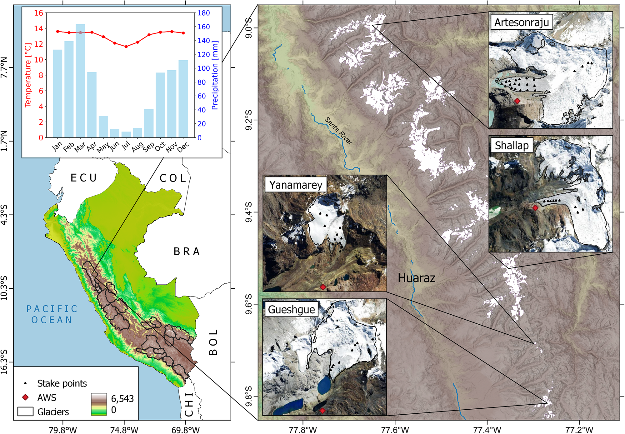
The glaciers monitored by UGRH-ANA in the Cordillera Blanca located in northern Peru. In the right panel, the stake network used for monitoring is shown as black dots for each glacier. UGRH-ANA also manages four AWS on the moraines of these glaciers, represented by red dots. The upper-left panel shows the monthly mean temperature and precipitation of the region based on daily data from three climatological stations (i.e. Sihuas, Recuay and Milpo) managed by SENAMHI, Peru.

2. Current state
2.1. Climate variability
The climate of the Cordillera Blanca is governed by regional systems such as the South American Low-Level Jet, South American Monsoon System (SAMS), Bolivian High (BH) and the Humboldt Current (Fernández-Sánchez and others, Reference Fernández-Sánchez2022). These systems drive a marked seasonality with a wet season from October to April and a dry season from May to September. Moist easterly winds associated with the SAMS and BH bring substantial summer precipitation, particularly to the eastern slopes, while winter is dominated by dry westerlies linked to the subtropical high-pressure system (Fernández-Sánchez and others, Reference Fernández-Sánchez2022). Precipitation is highly seasonal; the wet season (October to April, see Figure 1) accounts for 80% of the 800–1200 mm/year of precipitation (Mateo and others, Reference Mateo2022). Regarding temperature, the annually averaged 0°C isotherm is at about 4900 m a.s.l. with a small seasonal variability, but an overall increasing trend over the last decades of 1–2 m a−1, according to ERA5 data (Turner and others, Reference Turner2025).
Interannual climate variability in the Cordillera Blanca is influenced by large-scale forcings like the Intertropical Convergence Zone, Sea Surface Temperature anomalies, solar irradiance, the Madden–Julian Oscillation, the Pacific Decadal Oscillation and El Niño–Southern Oscillation (Vuille and others, Reference Vuille2008; Fyffe and others, Reference Fyffe2021; Fernández-Sánchez and others, Reference Fernández-Sánchez2022). These drivers impact precipitation patterns and temperature extremes, creating challenges for climate prediction, especially due to the region’s complex topography and sparse high-altitude meteorological data.
2.2. Glacier monitoring
Glacier monitoring in the Cordillera Blanca began in the 1970s with the installation of a network of stakes on the Yanamarey and Uruashraju glaciers, coordinated by the Unidad de Glaciologia e Hidrologia of the national company Electroperu (Ames and others, Reference Ames1988). From the 1990s to 2000s, international research groups such as the University of Innsbruck (Austria) and University of Wisconsin (USA) coordinated monitoring programs in this region together with Electroperu. Later on, the monitoring was coordinated by the Unidad de Glaciología y Recursos Hídricos of the Autoridad Nacional del Agua (UGRH-ANA) of Peru with continuing participation of foreign institutions like the above cited and the French National Research Institute for Sustainable Development (IRD). Currently, two national institutions are responsible for glacier monitoring in the Cordillera Blanca: the UGRH-ANA and the Instituto Nacional de Investigación en Glaciares y Ecosistemas de Montaña (INAIGEM).
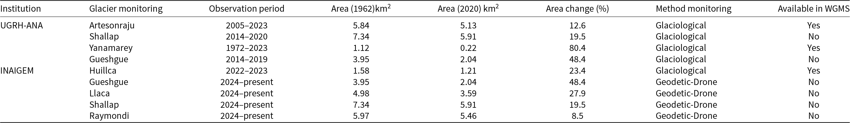
UGRH-ANA and INAIGEM conduct monitoring of seven glaciers in the Cordillera Blanca using the glaciological and geodetic methods with drones (Figure 1 and Table 1). The annual glacier-wide surface mass balance (SMB) of two glaciers (Artesonraju and Yanamarey) is reported and available through the World Glacier Monitoring Service (WGMS). Additionally, the UGRH-ANA manages four automatic weather stations (AWS) installed on the glacier’s moraine (Figure 1). INAIGEM is monitoring the SMB of four glaciers in the Cordillera Blanca using the geodetic method since 2024 (personal communication, Luzmila Dávila, INAIGEM), while the Glacier Huillca is monitored with the glaciological method, with data reported to the WGMS.

2.3. Glaciological and geodetic mass balance
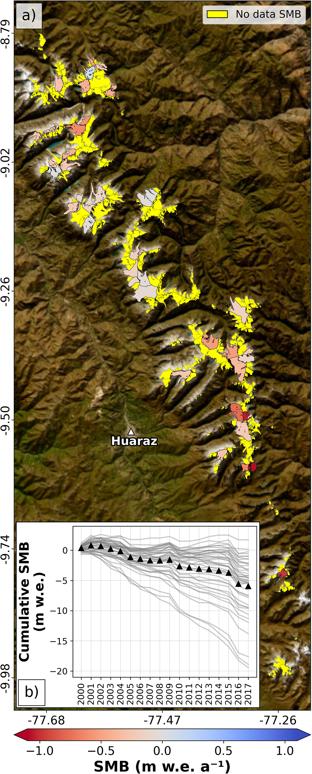
Figure 2 presents the annual mean glacier-wide SMB in the Cordillera Blanca, obtained from the equilibrium-line altitude (ELA) approach (Rabatel and others, Reference Rabatel2005, Reference Rabatel2012; Davaze and others, Reference Davaze2020) and through the glaciological method. Annual mean glacier-wide SMB data derived with the glaciological method are extremely limited. Overall, the glacier-wide SMB of these glaciers is predominantly negative, with a most negative absolute value reaching up to − 3.3 m water equivalent per year (m w.e. a−1) in 1980 during the 1972–2023 period.
(a) Annual mean glacier-wide surface mass balance (SMB) for 44 glaciers across the Cordillera Blanca for the period 2000–2017, based on the ELA approach (Rabatel and others, Reference Rabatel2005, Reference Rabatel2012; Gurriaran, Reference Gurriaran2019). (b) Cumulative SMB of the 44 glaciers obtained from remote sensing for the period 2000–2017, black triangles indicate the spatial average.

The first report on the SMB of glaciers in the Cordillera Blanca using the glaciological method was presented by Francou and others (Reference Francou1995). This study documented the SMB of the Yanamarey and Uruashraju glaciers (at 4700 m a.s.l.) for the hydrological years between 1977 and 1994, reporting a mean negative SMB of approximately −0.57 m w.e. a−1. Rabatel and others (Reference Rabatel2013) compiled and analyzed front position and SMB changes along the tropical Andes, including five glaciers in the Cordillera Blanca, for the 1974–2010 period. Analyzing the glacier-wide SMB from Rabatel and others (Reference Rabatel2013) data of just two glaciers in the Cordillera Blanca (Artesonraju and Yanamarey), we find a negative mass balance of −0.87 m w.e. a−1 during 1971–2009 period.
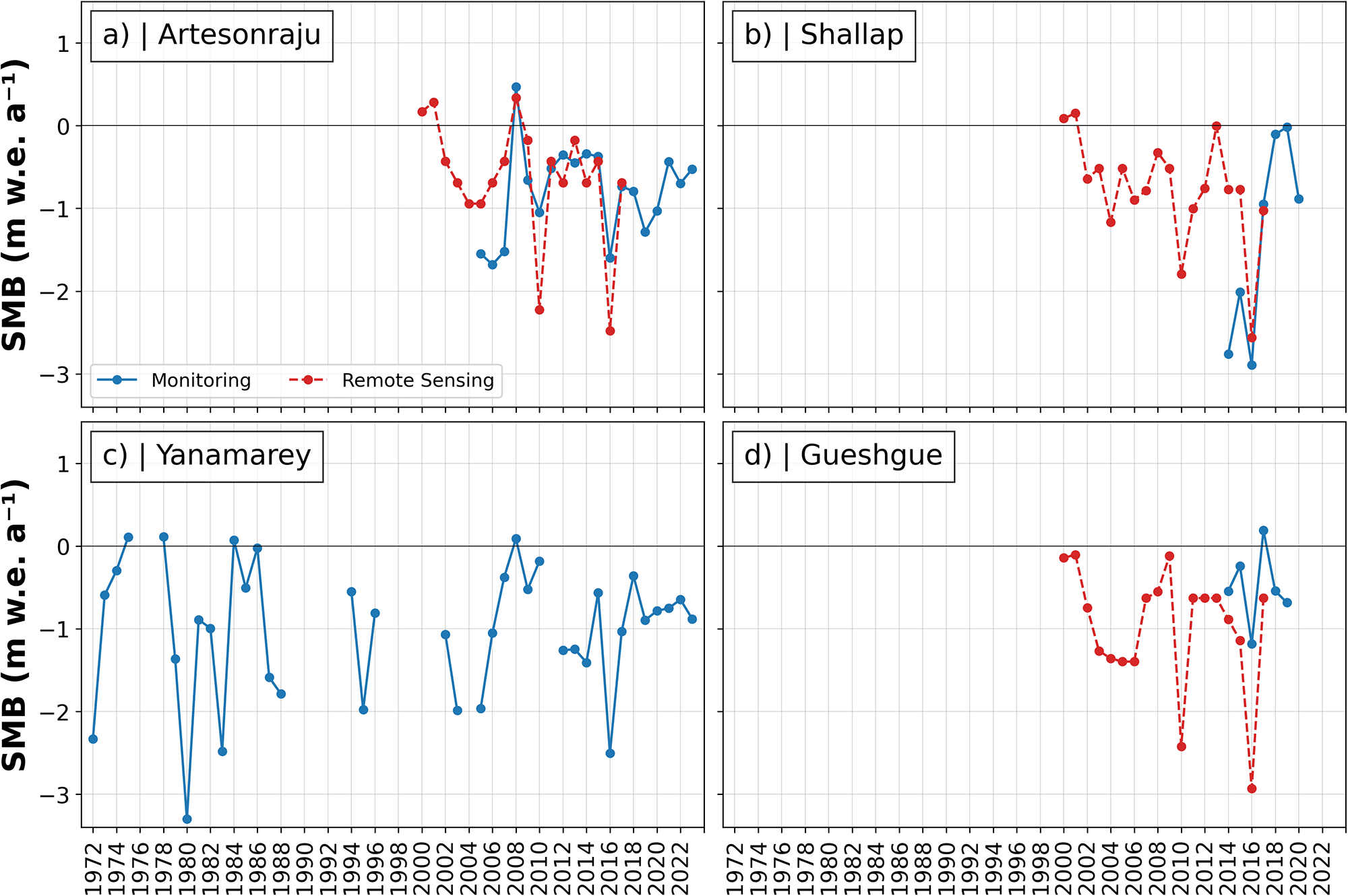
Additionally, Gurriaran (Reference Gurriaran2019) developed a dataset of annual mean glacier-wide SMB for 44 glaciers in the Cordillera Blanca for the period 2000–2017 (Figure 2a, b). She employed the ELA approach to estimate the annual mean SMB, combining the position of the snowline with elevation differences derived from two DEMs, a method used in several previous studies (e.g., Rabatel and others, Reference Rabatel2005, Reference Rabatel2012; Dussaillant and others, Reference Dussaillant2019). This dataset reveals considerable spatial variability in glacier-wide SMB, with annual mean ranging from −1.5 m w.e. a−1 to + 0.2 m w.e. a−1 depending on the glacier topographic and morphologic characteristics. The cumulative SMB also shows values ranging from + 2.60 to – 19.40 m w.e. during the 2000–2017 period. The comparison between glacier-wide SMB derived from the glaciological and remote sensing methods for the three glaciers (Figures 3a, b, d) shows a moderate correlation (r = 0.61), indicating that the remote sensing data capture the interannual variability of these glaciers. The remote sensing data provides a broader perspective on the current state of glaciers in the Cordillera Blanca. However, the dataset covers less than 10% (i.e., 33% of the area covered) of the total number of glaciers in the region, estimated at 511 glaciers (INAIGEM, 2023). Moreover, most glaciers in the Cordillera Blanca have surface areas smaller than 1.5 km2 and slopes steeper than 25°, which represent a significant challenge for obtaining accurate data through remote sensing techniques.
Comparison of annual glacier-wide SMB derived from in situ glaciological measurements and remote sensing data for (a) Artesonraju, (b) Shallap, (c)Yanamarey and (d) Gueshgue glaciers in the Cordillera Blanca from 1971 to 2023. Glacier-wide SMB observations were obtained from the UGRH-ANA, WGMS (2025) and Rabatel and others (Reference Rabatel2013) and remote sensing data were obtained from Gurriaran (Reference Gurriaran2019).

Global and regional studies have quantified the mass balance change of glaciers in the Cordillera Blanca (e.g., Braun and others, Reference Braun2019; Dussaillant and others, Reference Dussaillant2019, Reference Dussaillant2025; Seehaus and others, Reference Seehaus2019; Hugonnet and others, Reference Hugonnet2021). In particular, the study by Seehaus and others (Reference Seehaus2019) focused on the geodetic mass balance of Cordillera Blanca glaciers, reporting average mass loss rates of –0.07 m w.e. a−1 for the period 2000–2013 and −0.99 m w.e. a−1 for 2013–2016. Additionally, Dussaillant and others (Reference Dussaillant2025) recently quantified the annual mass balance change of the world’s glaciers by integrating data obtained through glaciological and geodetic methods. Their results indicated that in Region 16 – Low Latitudes, where the Cordillera Blanca is located, the mass change rate was −0.29 m w.e a−1 during the period 1979–2024, accelerating to −0.51 m w.e. a−1 in the last decade (i.e., 2015–2024). These results clearly indicate a significant acceleration in glacier mass loss in the Cordillera Blanca in the last years of their study period (2013–2016). While geodetic mass balance data provide a broader spatial perspective on glacier change in the region, their limited temporal resolution constrains our ability to understand interannual variability.
2.4. The vanishing of the Glacier Yanamarey
The Glacier Yanamarey is currently one of the WGMS reference glaciers in the Peruvian Andes. The first report of the glacier area was in 1948, with 1.7 km2 (Hastenrath and Ames, Reference Hastenrath and Ames1995a), obtained from aerial photogrammetry taken during a scientific expedition led by Kinzl (Reference Kinzl1949). In 1995, a more detailed analysis of the changes and dynamics of the Glacier Yanamarey and its relationship with the climate were presented by Hastenrath and Ames (Reference Hastenrath and Ames1995b). Glaciological monitoring programs on this glacier began in the 1970s with more than five decades of monitoring with some interruptions.
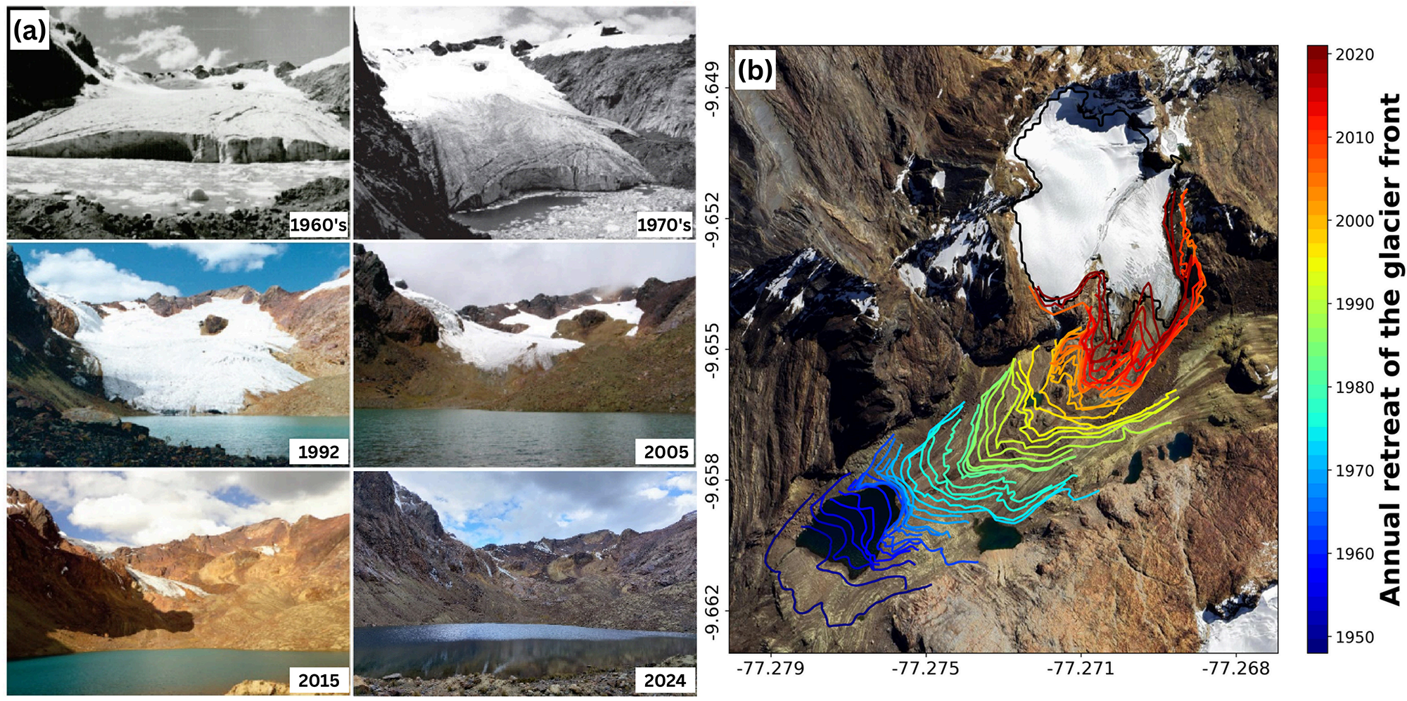
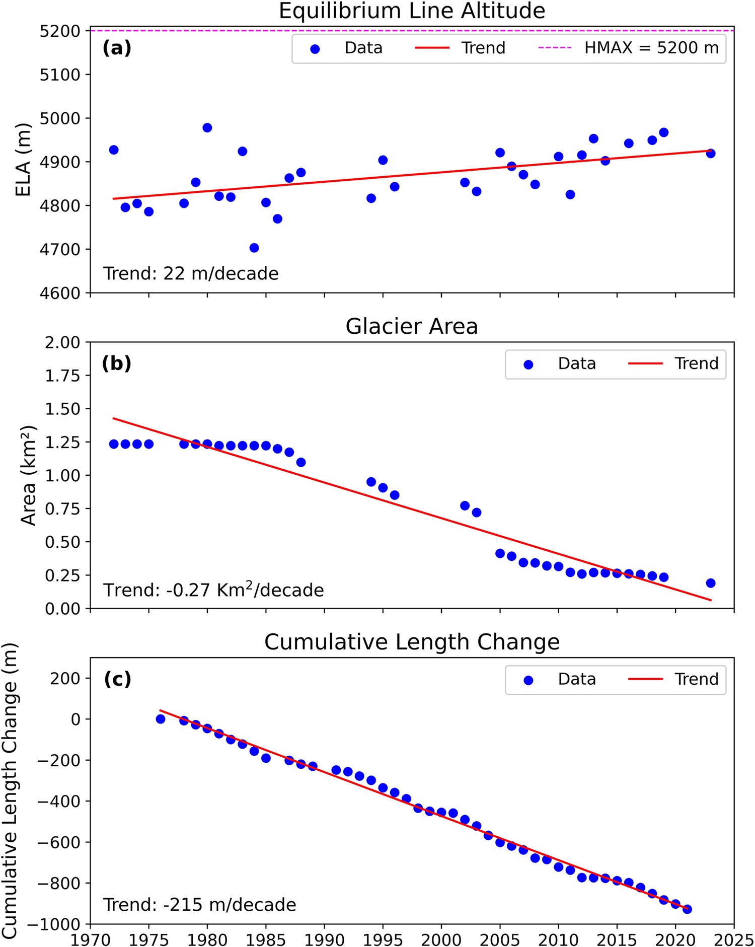
Figure 4a shows a series of photographs taken between 1960s and 2024 by UGRH-ANA, clearly illustrating the significant retreat of the glacier. This retreat is also confirmed by the marked recession of the glacier’s frontal position between 1948 and 2021 (Figure 4b). The data shown in Figure 5 were obtained from Rabatel and others (Reference Rabatel2013) for the period 1973–2008 and were completed with information provided by UGRH-ANA for 2009–2024 period. The ELA was determined from point SMB observation by applying a linear regression. The ELA was around 4850 m a.s.l. in the 1970s, with an upward trend of about 22 m per decade (Figure 5a). In 1971, the area was 1.2 km2, and since then it has exhibited a marked decreasing area trend of approximately 0.27 km2 per decade. Currently, the area of the Glacier Yanamarey is 0.2 km2 (Figure 5b). Furthermore, between 1970 and 2021, the glacier cumulative length change was −1000 m, with a trend of −215 m/decade (Figure 5c). The ELA shows a relatively linear rise, the area change shows an increase in the loss in 1985 but stabilized after 2005 and the length change shows a linear decrease.
(a) Time series of photographs of the Glacier Yanamarey taken between 1960’s and 2024 by UGRH-ANA. (b) Frontal position dates from 1948 to 2021. Photos sources: UGRH-ANA.

Evolution of Glacier Yanamarey ELA, area and cumulative length change during the 1970–2023 period.

3. Outlook: Perspectives and challenges
3.1. Difficulties in maintaining the monitoring network
Several challenges hamper the continuity and effectiveness of glacier monitoring in the Cordillera Blanca, which is carried out by UGRH-ANA and INAIGEM. For instance, the extreme geographical conditions, such as high elevation, steep slopes and crevasses endanger the safety of field staff making them prone to avalanches, landslides and rockfalls. Similarly, exposure to extreme weather, with temperatures below 0°C on the mountain peaks and low atmospheric pressure, demands a high level of physical fitness from the field staff. Budgetary constraints represent another major hurdle, affecting the funding for fieldwork, the acquisition of specialized equipment for glacial environments and the necessary maintenance of instruments to prevent data gaps. Additionally, a lack of training for staff to standardize data collection and processing is a significant obstacle. This prevents achieving a more spatially detailed, precise and higher temporal resolution monitoring. Moreover, many of the devices and instruments used are not specifically designed for glacial environments but have been adapted, which has led, for example, to the loss of drones due to weather conditions.
In response to this situation, the institutions turn to strategic partnerships, such as establishing partnerships with national and international projects. These projects often instrument glaciers of interest for specific research purposes using high-precision equipment. Once the studies are completed, the equipment is donated to one of these institutions, which focus their efforts on keeping the instruments operational and sustain measurements, and on making available most of the information they generate. The example we know refers to the collaboration between the University of Innsbruck, Austria and UGRH-ANA. Through international projects, the University of Innsbruck initiated monitoring of the Artesonraju and Shallap glaciers in the Cordillera Blanca by installing weather stations and stakes for monitoring surface mass balance. Subsequently, the equipment and techniques were transferred to UGRH-ANA, which currently maintains long-term monitoring of both glaciers.
3.2. Data scarcity
Studies utilizing surface mass balance and geodetic mass balance data have been relevant to advancing the understanding of glacier change in the Cordillera Blanca. However, both datasets exhibit notable limitations. Surface mass balance data are available for only a very limited number of monitored glaciers, while geodetic mass balance data cover all glaciers but lack sufficient temporal resolution, restricting insights into interannual variability and extreme climate events. These constraints present significant challenges for the implementation, calibration and validation of glacier mass balance models at the regional scale. Nevertheless, integrating surface mass balance and geodetic mass balance datasets can offer a more comprehensive and reliable understanding of glacier change in the region. In recent years, advances in glacier modeling have included the application of novel methodologies, such as machine learning techniques (e.g., Bolibar and others, Reference Bolibar, Rabatel, Gouttevin, Galiez, Condom and Sauquet2020; Sjursen and others, Reference Sjursen2025), which enable the integration of diverse data sources to improve mass balance estimations.
3.3. Future recommendations
Glaciers in the Cordillera Blanca are experiencing significant mass loss, a situation that is causing changes in the runoff process and consequently instability in the availability of water resources (Vuille and others, Reference Vuille2008; Rabatel and others, Reference Rabatel2013; Seehaus and others, Reference Seehaus2019; Caro and others, Reference Caro2025). Therefore, it is fundamental to improve projections of glacier changes in the region. However, the accuracy of global climate models in this region remains problematic due to the challenge of realistically simulate the complex terrain and inherent climate characteristics. In this context, Turner and others (Reference Turner2025) used ERA5 reanalysis data and 35 CMIP6 climate models to study four tropical Andean glaciers, identifying that the Freezing Level Height (FLH) for the Glacier Artesonraju would increase in altitude, reaching ∼5400 m and ∼ 5950 m a.s.l. under SSP2-4.5 and SSP5-8.5 scenarios, respectively. Notwithstanding this trend, projections indicate that Glacier Artesonraju has a high probability of persisting with a small accumulation zone through the year 2100 (SSP2-4.5 and SSP5-8.5). Moreover, Tacsi and others (Reference Tacsi2025) evaluated the Yanamarey micro-basin to determine its runoff dynamics by applying the GSM (Glacier Snow Melt) and SOCONT (Soil Contribution) models, as well as the RegCM4 regional model of CMIP5 under RCP 2.6 and 8.5 scenarios. Their results indicate that this regional model predicts that the ice mass will be fully converted into runoff in 2030 under the RCP 8.5 scenario and 2036 under the RCP 2.6 scenario. According to the UGRH-ANA, the reduction in the area of the Glacier Yanamarey has resulted in a minimal accumulation zone, which has been reflected in increasingly negative SMB values in recent years. The UGRH-ANA has stated that the monitoring of the Glacier Yanamarey will continue until it is completely vanished, which is projected to occur within the next one or two decades when considering the increase in ELA and the maximum elevation of the glacier. The current retreat of the glacier has influenced both the monitoring results and strategies, as the pronounced negative mass balance observed across the Cordillera Blanca has required expanding the observation network to nearby glaciers with more representative and sustainable conditions for long-term monitoring.
Furthermore, glacier retreat has led to the formation of glacial lakes and increased slope instability by several glaciers. Therefore, glacial lake outburst floods are becoming more frequent in the region (Emmer and others, Reference Emmer2020; Wood and others, Reference Wood2021). However, the processes of its formation, evolution and catastrophic drainage are not fully understood (Wood and others, Reference Wood2021) and require a more detailed analysis.
To further enhance long-term glacier monitoring efforts, we would like to suggest: (1) considering the designation of reference glaciers by region and institution, as current monitoring by INAIGEM and UGRH-ANA is mostly concentrated in the Cordillera Blanca. Expanding reference sites to other regions could help improve geographic coverage and increase the number of glaciers monitored systematically. (2) Exploring opportunities to standardize monitoring techniques using stakes and drones. A more balanced distribution of stakes—with fewer in the ablation zone and some placed in the accumulation zone—could provide more representative estimates of total glacier mass balance and accumulation processes. In addition, a unified protocol for drone operations, from image acquisition to postprocessing and digital elevation models generation, could be beneficial. Institutions such as INAIGEM, UGRH-ANA and local universities might consider organizing a technical workshop to share experiences and agree on standardized procedures.
Finally, future research should aim to combine complementary datasets (surface mass balance and geodetic mass balance) and benefit from machine learning techniques to strengthen glacier modeling in the Cordillera Blanca. This letter highlighted what we consider the most significant challenges, offered some ideas for addressing them and contributed to the United Nations 2030 Agenda for Sustainable Development, in commemoration of the International Year of Glaciers’ Preservation 2025.
Data availability statement
The data are available from Torres Ramos and others (Reference Torres Ramos2025) Vanishing of the Glacier Yanamarey, one of the four glaciers with in situ measurements in the Cordillera Blanca, Peru [Data set]. Zenodo. (doi:10.5281/zenodo.17536354).
Acknowledgements
We acknowledge support from GEO Mountains under the Swiss Agency for Development and Cooperation (SDC)’s Adaptation at Altitude Programme (Project Number: 7F-10208.02.01). This work is based on the framework of the GEO Mountains Small Grants Programme 2024–2025, project ‘Modeling of the surface energy balance and surface mass balance for several glaciers of the Cordillera Blanca using physical numerical models and artificial intelligence.’ Thanks also to the support of the project CAPES-CLIMAT AMSUD 88881.878909/2023-01 (TROPIPOLAR-GLASCLIM). C.B. was supported by the AmSud Mobilizations-Contract Research N°PE501084098-2023-PROCIENCIA. C.T. was supported with a postdoctoral fellowship by the Coordenação de Aperfeiçoamento de Pessoal de Nível Superior - Brasil (CAPES)—Finance Code 001.
Competing interests
The authors declare that the research was conducted in the absence of any commercial or financial relationships that could be construed as a potential conflict of interest.

 Open access