

Introduction
Beginning in 1991, NASA conducted near-annual airborne surveys over Greenland, using a scanning laser altimeter (the Airborne Topographic Mapper (ATM)), in order to map rates of surface elevation change over the entire ice sheet. Results (Reference KrabillKrabill and others, 2000) show higher-elevation (above ∼2000m) parts of the ice sheet to be in overall balance, although with regions of local thickening or thinning, and near-coastal thinning at rates that are increasing with time (Reference KrabillKrabill and others, 2004). Although coastal temperatures also increased during the survey period, low-elevation thinning rates in many areas are too high to be explained totally by increased surface melting (Reference AbdalatiAbdalati and others, 2001), and perhaps a third of the thinning is caused by outlet glacier velocities exceeding those required to balance upstream snow accumulation (Reference KrabillKrabill and others, 2004).
NASA’s Ice, Cloud and land Elevation Satellite (ICESat) was launched in January 2003, carrying the Geoscience Laser Altimeter System (GLAS) with three lasers to be operated sequentially in order to achieve a mission lifetime of 3-5 years. Its prime objective was to measure the rate of change of surface elevation of the Greenland and Antarctic ice sheets (Reference ZwallyZwally and others, 2002). Data acquisition began on 21 February 2003, but Laser 1 prematurely failed after operating for 37 days in an 8 day repeat ‘validation’ orbit. In order to conserve the lifetime of the remaining two lasers, it was decided to adopt a strategy whereby the active GLAS laser would complete a 33 day sub-cycle of a 91 day repeat orbit and then be switched off intermittently. Subsequent operations would depend on results from this initial period.
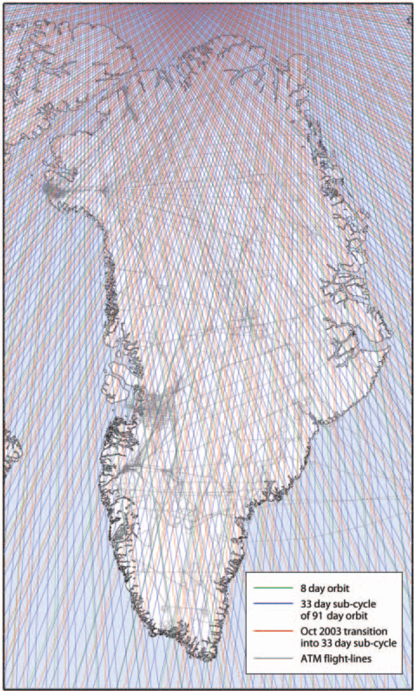
Following this plan, Laser 2 was activated on 25 September 2003, and, after completing one 8 day cycle, ICESat was shifted to the 91 day repeat orbit until 18 November 2003, with the 33 day sub-cycle completed after mid-October selected for future repeat surveys. Laser 2 was reactivated with ICESat in this same sub-cycle for the 33 day periods 18 February-23 March and 18 May-21 June 2004. Figure 1 shows flight tracks for all ATM surveys over Greenland between 1993 and 2003. Most of these were completed during May, near the start of the ablation season, but those in 1993 and 1998 (mainly over the southern part of the ice sheet) were completed in June-July at the height of the melt season. Figure 1 also shows all of the ICESat orbit tracks. Here, we present results from comparison of ICESat data with earlier ATM-derived elevations over the Greenland ice sheet.
ATM flight tracks over Greenland, surveyed between 1993 and 2003, are shown by thin black lines. ICESat orbit tracks are shown in blue (8 day ‘validation’ tracks surveyed in February–March and late September 2003); red (33 day sub-cycle of the 91 day repeat orbit surveyed in October–November 2003, and February–March and May-June 2004); and green (additional 13days of the 91 day repeat, surveyed in early October 2003).
Methods
The ATM conically scans the surface beneath the aircraft at an off-nadir angle of 15-22.5˚, scan rate of 20 Hz and laser-pulse repetition rate of 5000 Hz, to measure elevations of a dense array of footprints within a swath beneath the aircraft. At typical aircraft elevations of 500 m and aircraft speed of 150ms–1, footprint size is 1 m, swath width is 250-400 m and distance between footprints is about 5 m. The GLAS instrument aboard ICESat is a nadir-looking sensor with a pulse repetition rate of 40 Hz. Laser footprints are about 70m in diameter and 170m apart (Reference ZwallyZwally and others, 2002). In order to compare elevations derived from ATM with those from ICESat, we had to take account of differences between the footprint sizes of the two lasers. Overlapping (by 50%) planar surfaces, or ‘platelets’, were fit to the ∼1200 aircraft measurements on each side of the aircraft within a 70m along-track distance, generally with rms fit of 10 cm or less. These were compared with ICESat footprint elevations by extrapolating elevations from any platelet within 200 m distance using the platelet slope. This generally yielded four comparisons for each GLAS footprint, and these were averaged to give the GLAS/ATM comparison for that footprint.
Errors
Based on elevation comparisons along repeat aircraft tracks, at points where tracks cross each other and where they pass over independently surveyed points, elevation accuracy of the ATM platelets is approximately ±10cm (Reference KrabillKrabill and others, 2002). However, errors are magnified at the edges of the scanned swath because of laser-pointing errors, with effects magnified by the 15-22.5˚ off-nadir scan angle. For the ∼500 m altitude flown and a typical maximum roll error of 0.05˚ (effects of pitch errors are mostly averaged out in the platelet calculation), the resulting elevation error is <20cm, with opposite signs on each side of the surveyed swath. However, because we averaged ICESat/ATM comparisons that included data from each side of the aircraft, effects of these roll errors should be largely cancelled, but here we assume a residual error of ±10 cm. Other ATM error sources contribute <10cm, largely caused by uncertainty in GPS-derived aircraft trajectories, implying total ATM elevation errors of about ±15 cm.
Accuracy of GLAS measurements is determined mainly by errors in laser pointing, and by distortion of the return waveform by saturation effects over bright surfaces and by forward scattering in thin clouds. To a large extent, waveform distortion can be identified from information on how well the waveform can be fit by a Gaussian shape, and we used this as a filter to remove ‘bad’ waveforms. We estimated ICESat pointing errors for the September-November 2003 and the February-March 2004 measurements to be typically <5arcsec by comparing GLAS data with aircraft ATM surveys over undulating terrain in Antarctica and arid parts of the western United States. These estimations used time offsets between waveforms synthesized from ATM data along the satellite track and actual GLAS waveforms to compute range residuals from which least-squares estimates of range bias (∼2cm) and pointing errors were estimated. Consistent estimates were also made over Greenland using 2003 ATM survey data, but with less accuracy due to smaller surface slopes and temporal variations in surface elevation. Most of our Greenland surveys were over slopes <1 :100, resulting in slope-induced errors of 15 cm or less. Including effects of GLAS range errors (estimated to be <10cm, including true range bias plus effects of forward scattering and pulse saturation), this results in GLAS elevation errors <18cm. Consequently, estimated errors in elevation changes between ATM and September 2003-March 2004 GLAS surveys should be ± 2 4 cm or less for data collected over most of the ice sheet.
At the time of writing, ICESat pointing errors for February-March 2003 and May-June 2004 data are temporally varying, with values up to 40 arcsec. Although these errors will be reduced in future data releases, errors in elevation changes using the current data release are variable and may exceed 1 m in some places. Moreover, it is important to note that errors increase almost linearly with surface slope. This means that, over central parts of the ice sheet, errors are less than estimated here, but they are larger near the coast. Moreover, deliberate off-nadir pointing of the GLAS laser, in order to follow repeat tracks exactly, also increases the effect of pointing errors. Generally, this had negligible impact because off-nadir angles were very small, but pointing by up to 5° to survey 8 day orbit tracks from the 91 day repeat mapping orbits increased the effects of pointing errors substantially, and we omitted GLAS data obtained at off-nadir angles >3°.
Most of the error sources should be independent for different ATM flights and for different ICESat orbits, with only range biases between the two sensors introducing systematic errors into all GLAS/ATM comparisons. Consequently, elevation changes, averaged over large regions that include many ATM flight-lines and ICESat orbit tracks, should have smaller errors than estimated above, particularly at higher elevations in the north, where there are many comparisons, increasing below 1000 m elevation and in parts of southern Greenland where data coverage is sparse. The ATM data were collected during many flights over several years, with independent range calibrations, aircraft trajectories, etc., so that systematic elevation errors should be very small. However, GLAS-derived elevations may be biased too low, because the Gaussian fits used to process return waveforms yield elevations shifted slightly below the real surface if the waveform is broadened by forward scattering, energy saturation or very rough surfaces.
Although we have no ATM measurements over ice sheets taken simultaneously with GLAS data, we do have ATM data over Greenland from May 2003 that we compared with GLAS measurements made in February-March 2003. Initial results show an apparent thickening by about 10 cm during the 2–3 months interim along most ICESat orbit tracks, but with considerable scatter. Part of this thickening is probably real, because this was a period of quite heavy snow accumulation in the south (Reference Hanna, McConnell, Dias, Cappelen and StephensHanna and others, 2006), and the scatter is consistent with higher ICESat pointing errors during this period, and expected geophysical ‘noise’ associated with spatial variability in both snowfall and dh/dt. Consequently, although GLAS range bias is the subject of ongoing investigation, our results suggest that it is consistent over ice with that inferred from our analyses over land. Moreover, these results lend confidence to the use of averaged comparisons with early GLAS data, despite their larger pointing errors.
Results
Having edited from the GLAS data ‘bad’ waveforms and high off-nadir pointing, as described above, we compared all GLAS data with all ATM data to calculate rates of elevation change (dh/dt) between the dates of respective surveys. Although we rejected all elevation-change rates greater than 5 m a–1, results are very noisy, partly because of the errors discussed above, but also because rates of elevation change vary both seasonally and interannually. Consequently, the data were gridded on a polar stereographic projection, where gridcells that contained data received a value equal to the median of all measurements within a 50 km radius; the gaps were then filled by a bilinear interpolation over the Delaunay triangulation of these gridcells. This is shown in Figure 2a and can be compared with equivalent results obtained by inter-comparing ATM surveys from 1993/94 and 1998/99 (Reference KrabillKrabill and others, 2000) shown in Figure 2b. The two sets of results show similar patterns of elevation change, with generally small changes at higher elevations and predominant thinning near coasts.
Greenland, showing rates of elevation change (dh/dt) derived from: (a) comparison between all GLAS data from 2003 and 2004 and all ATM data collected between 1993 and 2002, with our estimated values of dh/dt (with dark outlines) laid over a filtered and interpolated version of the same data; and (b) comparison of ATM surveys in 1993/94 with surveys along the same tracks in 1998/99. Panel (a) includes locations of Jakobshavn (J), Kangerdlugssuaq (K), Humboldt (H) and Petermann (P) glaciers and the ‘Northeast Greenland Ice Stream’ (NE).
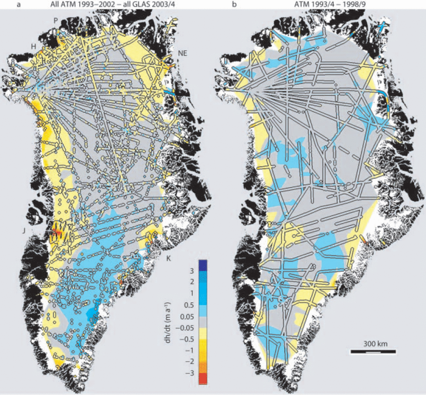
Figure 2a includes comparisons between GLAS data and ATM measurements dating back to 1993. It shows a general trend towards increased coastal thinning along the west, north and northeast sides of the ice sheet, a shift from earlier thickening to near balance at higher elevation in the north, and strongly increased thickening at higher elevation in the southeast. These trends are consistent with similar ones shown by inter-comparison of ATM data acquired since 1997 (Reference KrabillKrabill and others, 2004). However, the results in Figure 2a are averaged over different periods during the last 10 years and are further blurred by seasonal effects. Consequently, in order to focus on changes since the late 1990s and reduce the effects of seasonal changes, we isolated comparisons between September–November 2003 GLAS data and June– July 1998 ATM data (Fig. 3a), and between GLAS data acquired in February–March and May–June 2004 and ATM data obtained in May of 1997 and 1999–2002 (Fig. 3b). Although this does not totally remove seasonal effects, it should give a good indication of recent changes. We also compared GLAS data from February–March 2003 with May ATM data since 1997 to obtain results similar to those shown in Figure 3b, and we have not included them here.
Greenland, showing rates of elevation change (dh/dt) since the late 1990s, derived from: (a) comparison of GLAS data from September–November 2003 with ATM data from June–July 1998; and (b) comparison of GLAS data from February–March and May–June 2004 with ATM data collected in May during 1997 and 1999–2002. Values of dh/dt along the off-nadir pointed ICESat orbit running north-northwest to south-southeast along the ice-sheet centre line and shaded yellow are suspect because they differ from nearby estimates.
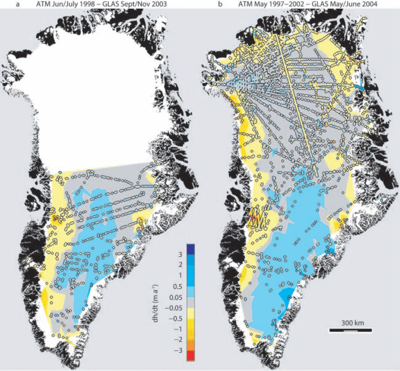
Figure 3a and b show patterns of elevation change very similar to those in Figure 2a, with Figure 3b clearly showing increased thickening in the southeast, compared to Figures 2b and 3a, and increased thinning in the Jakobshavn Isbræ drainage basin. Other studies (Reference KrabillKrabill and others, 2004; Reference Hanna, McConnell, Dias, Cappelen and StephensHanna and others, 2006) indicate that extremely high snowfall in the southeast during 2002 and 2003 exceeded longer-term regional thinning over most of the area, with warmer summer temperatures having progressively increased thinning rates over most coastal regions (Reference KrabillKrabill and others, 2004). Very rapid recent thinning over large areas of the Jakobshavn catchment basin has also been inferred from ATM surveys (Reference Thomas, Abdalati, Frederick, Krabill, Manizade and SteffenThomas and others, 2003; Reference ThomasThomas, 2004). Moreover, as its floating tongue thinned and finally broke up, Jakobshavn Isbræ accelerated after 1997 with speeds progressively increasing to almost double pre-1997 values by 2003 (Reference Joughin, Abdalati and FahnestockJoughin and others, 2004 ).
In the south, Figure 3b shows similar trends to Figure 3a, but with an intensification of thinning in the Jakobshavn drainage basin. This is partly associated with increased data coverage, but also reflects the progressive increase in local thinning rates (Reference Thomas, Abdalati, Frederick, Krabill, Manizade and SteffenThomas and others, 2003) captured by GLAS comparisons in Figure 3b with more recent ATM data than in Figure 3a. Thinning has also intensified on Kangerdlugssuaq Isbræ, which is thinning rapidly, despite the shift further south from thinning to thickening associated with anomalously high snowfall during 2002 and 2003. In the north, Figure 3b shows an overall tendency towards increased thinning compared to 1994–99 (Fig. 2b), with a clear intensification and enlargement of all near-coastal thinning zones. Indeed, thinning rates for all coastal regions have increased, except in the southeast.
Ice-Volume Changes
In order to estimate total ice losses associated with the elevation changes inferred from the different GLAS/ATM comparisons, we used the interpolated estimates of elevation-change rates from each of the comparison periods to calculate total volume changes for that period, shown in Table 1, assuming uplift of the ice-sheet bed of 0.5 cm a–1. All three estimates for the entire ice sheet are in reasonable agreement with the loss of 51 km3 a–1estimated for 1993/94 to 1998/99 (Reference KrabillKrabill and others, 2000). Differences between the estimates result partly from random errors in various data, partly from differences in spatial coverage of the data, and partly from real differences in rates of elevation change during the different time periods corresponding to the three estimates. In addition, there may be a slight elevation bias (estimations indicate 1–2 cm) between GLAS data from February–March 2003 and those from February–March 2004, because the earlier data were acquired with a different laser.
Rates of ice-sheet volume change (dV/dt) of the Greenland ice sheet excluding near-coastal regions, inferred by comparing GLAS and ATM measurements, corrected for 0.5 cma–1 basal uplift
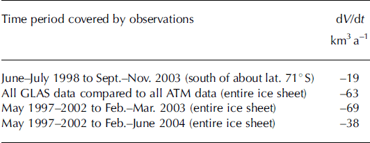
Results are least reliable for near-coastal regions where data coverage is sparse, spatial variability of dh/dt is large and slope-induced GLAS errors reach maximum values. Moreover, there are few GLAS/ATM comparisons over the regions of most rapid change near the coast, so these estimates of volume change do not include the effects of very rapid changes, such as those in the Jakobshavn basin. Consequently, the values for volume loss in Table 1 represent lower limits.
Further inland, at elevations above about 2000 m, spatial distribution of GLAS/ATM comparisons is more uniform, and estimated average values for dh/dt should be more accurate. Here, we also have three independent estimates of average rates of thickness change from repeat ATM and satellite radar-altimeter surveys, and from comparison of total ice discharge with total snow accumulation (Reference ThomasThomas and others, 2001). These estimates, corrected for isostatic uplift of the ice-sheet bed (0.5cma–1 averaged over the entire ice sheet, and 0.4 cm a–1 for the southern half) are listed in Table 2, along with those resulting from the present study for the ice sheet above 2000 m elevation.
Average rates of elevation change (dh/dt (mma–1)) above about 2000 m elevation for the Greenland ice sheet from repeat ATM (ATM/ATM) and satellite altimetry (SA) time series, mass-budget (MB) and GLAS/ATM comparisons. ΔT is the time period of observations, and is probably longer than shown for MB. All GLAS–All ATM refers to a range of time periods, with ATM data from 1993 to 2003, and GLAS data from 2003 and 2004
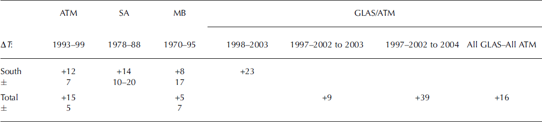
The four values of dh/dt for the southern part of the ice sheet all show agreement to within estimated errors of two of the earlier surveys, with a possible recent increase in thickening rates, consistent with very high snowfall during 2003 (Reference Hanna, McConnell, Dias, Cappelen and StephensHanna and others, 2006). For the entire ice sheet, only the value of dh/dt based on 2004 GLAS measurements is outside the error bounds of the earlier surveys, and this also may partially result from high snowfall during 2003. Taking account of the approximately 5 year average interim between ATM and 2004 GLAS measurements, the increased thickening rate (by 2cma–1) could have resulted from an overall increase in surface elevation by 10 cm between early 2003 and early 2004. This is equivalent to an increased precipitation during this period by about 3cmw.e. averaged over the ice sheet, consistent with European Centre for Medium-Range Weather Forecasts (ECMWF) model analyses (personal communication from E. Hanna, 2004).
Discussion and Conclusions
Results presented here show that elevation-change rates averaged over the Greenland ice sheet, derived from comparison between aircraft ATM and ICESat surveys, are in good agreement with those derived solely from aircraft data. This indicates that errors in the ICESat data are mainly random, with range bias probably <2 cm. However, data from individual segments of an ICESat orbit are affected by temporally changing pointing errors, producing elevation errors proportional to local surface slope. The effect of these errors on elevation-change estimates can be reduced by averaging results from several orbits within a region. Ongoing efforts by the GLAS Science Team should reduce these pointing errors. It will then be possible to estimate the degree of averaging required to achieve a desired elevation-change accuracy.
At the time of writing, GLAS lifetime is not expected to extend beyond 2005, with 33 day GLAS surveys planned for late 2004 and early 2005. Although this will extend the time series of Greenland measurements, it is clear from the temporal variability revealed by ATM surveys that more surveys will be needed in order to resolve issues such as whether dynamic changes that have occurred recently will result in a permanent increase in ice discharge from the ice sheet. The upcoming European Space Agency CryoSat mission should help to provide the needed data, but we have yet to determine whether meaningful comparisons can be made between laser-derived elevations and those inferred from CryoSat radar data. CryoSat under-flights with the ATM will help to resolve this, but, over the longer term and particularly for Antarctic investigations, a follow-on satellite laser altimeter is urgently required.
Acknowledgements
We thank NASA’s ICESat project for acquiring and processing the GLAS data, and members of the GLAS Science Team for helping to identify and correct various errors in the data. We also thank J. Sonntag for preparing Figure 1 , E. Hanna for sharing his modeling result from ECMWF analyses, and the many individuals who have helped to acquire and process ATM data over Greenland. Funding support was provided by NASA’s ICESat Project and Cryospheric Processes Program.


