


Introduction
Late Palaeolithic settlement in the western part of the Lublin Upland remains poorly investigated. The earliest data on this subject date to the interwar period when archaeological research was conducted in the south-west part of this area. This yielded Turonian flint outcrops and flint workshops of undetermined cultural provenance.
Investigations of pre-Neolithic settlement undertaken by J. Libera in 1981–1992 were instrumental in organising and systematising knowledge of the Late Palaeolithic in the western Lublin Upland. Libera's primary focus was on re-evaluating archival museum collections. This research was published in an overview of the Late Palaeolithic and Mesolithic in central-east Poland (Libera Reference Libera1995, Reference Libera1998). To date, 80 archaeological sites associated with the Late Palaeolithic are recognised in the western Lublin Upland. The vast majority of finds originate from regular surface surveys conducted in the 1980s by many researchers (Libera Reference Libera and Wiśniewski2015). A considerable number of them are chance finds with an undetermined location.
Artefactual material obtained from previous surveys is exceptional in its homogeneity, consisting almost entirely of flint and stone artefacts. As the chronology of nearly all earlier finds is based only on their classification and typo-technological analysis, this archive of material is not a sufficient source for a full reconstruction of settlement. To date, traces of the Magdalenian Technocomplex (Late Magdalenian Culture), the Arch-Backed Pieces Technocomplex (Federmesser Culture) and the Tanged Points Technocomplex (mainly the Swiderian Culture) have been recorded in the discussed area (Libera Reference Libera and Wiśniewski2015).
The only site in the western Lublin Upland to have been dated using chronometric methods, and where the stratigraphic position of finds has been determined, is the Magdalenian settlement in Klementowice (Wiśniewski Reference Wiśniewski2015). The remains of settlement discovered there are dated to the late Oldest Dryas (c. 13 000 BP) and are now recognised as the oldest traces of hunter-gatherers in the Lublin Upland after the Last Glacial Maximum.
Excavations were conducted at a flint workshop site in Kopiec, which was related to the Tanged Points Technocomplex (the Swiderian Culture) based on typo-technological analysis (Libera Reference Libera1998), yet neither in-depth analysis of the stratigraphy of the site nor radiometric dating has been conducted.
A research project designed to examine Late Palaeolithic settlement sites and the environmental conditions in which they developed was led by one of the authors (T.W.) between 2015 and 2019. Taking in an area of approximately 4800km2 of the Lublin Upland in eastern Poland and gathering evidence for sites developing between the Last Glacial Maximum and the beginnings of the Holocene (the Preboreal period), the Late Palaeolithic Settlement in the Western Part of the Lublin Upland (LPSWLU) project yielded much new data for the study of the Late Upper and Late Palaeolithic in Central Europe.
Methods
The LPSWLU project aimed to verify existing data on the settlement of hunter-gatherers in the Late Palaeolithic as well as conduct surveys to record new data. Initial project tasks were to verify and analyse archival records. Following this, surveys of the areas known to be find-locations of flint or stone artefacts with typo-technological features characteristic of Late Palaeolithic materials were undertaken. The natural environment of the area consists of mesoregions of diverse soils and a river network; understanding this environment is vital to our interpretation of settlement sites. Archival data reveal that the sites are concentrated on the upper and middle stretches of rivers, and in places where tributaries flow into larger rivers.
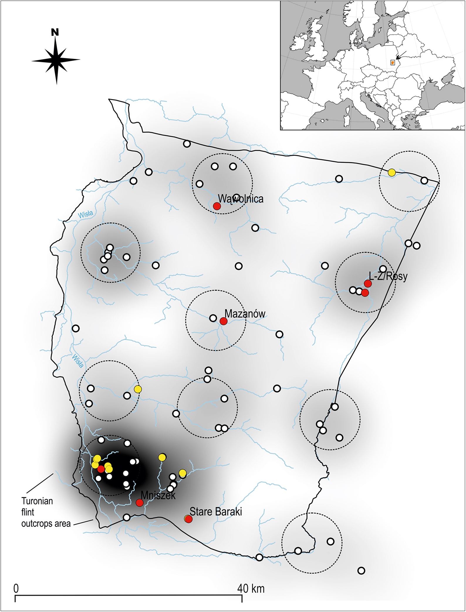
Areas for detailed survey were determined using a GIS model, which showed the microregions most densely covered by sites and mapped a 10km survey radius around each (Figure 1). This approach was adopted from ethnographic studies, which show that a group of hunter-gatherers typically explore a range of up to 10km around their main camp (Bailey Reference Bailey, Renfrew and Bahn2005). This stage involved acquisition of new artefacts and samples for specialist analysis. All artefacts recovered during surveys were georeferenced using Garmin GPS Map 64st. Positive results of surface surveys made it possible to plan and undertake excavations.
Map of survey area in the western part of the Lublin Upland showing concentrations of sites (based on the GIS model). Unconfirmed sites marked by white dots; verified sites marked by yellow dots; excavated sites marked by red dots (illustration by T. Wiśniewski).
Results
The fieldwork involved verification of 80 sites known from earlier research; these sites were discovered mainly by surface surveys and chance finds. To be verified, sites needed to be accessible to survey and have evidence for artefacts. Of the 80 sites, 63 could not be verified, which means that either no artefacts were found or that the area was not accessible to survey. It was possible to verify 17 sites, however, and of those, seven sites were identified for excavation. The decision to excavate was based on the best results of surface surveys.
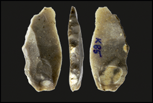
Some of the most fascinating discoveries are sites with evidence for flint and stone artefacts associated with Magdalenian settlement at Stare Baraki (Figure 2) and Wąwolnica (Figure 3). Discoveries of flint artefacts made at Lublin-Zemborzyce (ul. Rosy) (Figure 4) and Mniszek confirmed the presence of settlement connected with the Arch-Backed Pieces Technocomplex. Single artefacts from the Tanged Points Technocomplex (Mazanów) were also found there. Investigations at two sites in Annopol and Lublin-Zemborzyce (Rudki Forest) yielded the remains of settlement from later periods (Mesolithic, Neolithic and Bronze Age).
Top) Stare Baraki location map; middle) site under excavation; bottom) selected Magdalenian flint artefacts (photographs by T. Wiśniewski, based on a map from geoportal.gov.pl).

Top) Wąwolnica location map; middle) site under excavation; bottom) selected Magdalenian flint artefacts (photographs by T. Wiśniewski, based on a map from geoportal.gov.pl).

Top) Lublin-Zemborzyce, ulica Rosy location map; bottom) selected Arch-Backed artefacts (photographs by T. Wiśniewski; based on a map from geoportal.gov.pl).

The results show a clear preference for particular locations for Palaeolithic settlements. Magdalenian communities preferred loess plateaus; these locations, near rivers and streams, offered excellent views of the environs. Settlements connected with the Arch-Backed Pieces Technocomplex and the Tanged Points Technocomplex are most often found on aeolian sand deposits in valleys, right next to, or at a short distance from, rivers.
The project has demonstrated that the dearth of Late Palaeolithic settlement in the Lublin Upland is a result of the limited research conducted there. Our results enhance understandings of cultural processes that took place during recolonisation, particularly in the eastern part of Central Europe, after the last glaciation, and will be fundamental in encouraging further research in this region and informing research directions.
Conclusions
Previous research assumed that the Lublin Upland was a peripheral territory, visited only periodically. The new evidence for Magdalenian settlement in Stare Baraki and Wąwolnica forces us to rethink this hypothesis and suggests instead that this region had a compact and continuous Magdalenian occupation. Particularly relevant is the confirmed settlement of the Arch-Backed Pieces Technocomplex (Lublin-Zemborzyce, ul. Rosy and Mniszek). Until now it has been difficult to determine whether this type of settlement had ever reached as far as the east of the Vistula River, as only single finds were known from the area. The project results therefore not only shed new light on the settlement of these communities in the Lublin region, but also redraw the eastern border of this cultural unit (Sobkowiak-Tabaka Reference Sobkowiak-Tabaka2017). The fieldwork was not able to confirm the numerous settlements connected with the Tanged Points Technocomplex (Swiderian Culture) that were recorded in the 1920s (Libera Reference Libera1998). The project results will reinvigorate debate on the location of the eastern frontiers of the Magdalenian and its relations with other cultural traditions, in both the region and in the wider context of Central Europe.
Acknowledgements
We thank Karol Standzikowski and Magdalena and Maciej Krajcarz for their scientific support. We are especially grateful to the members of the 2017 and 2018 field teams: Angelika Bachanek, Damian Bednarczyk, Magdalena Król, Aleksandra Ferenc, Natalia Kisiel, Oleh Lobai, Patryk Mazurek and Magdalena Omelańczuk. Finally, our thanks go to Lila and Aleksander Kaczor for their hospitality and help.
Funding statement
Research was conducted as part of the science project Late Palaeolithic Settlement in the Western Part of the Lublin Upland financed by the National Science Centre, Poland (2014/15/N/HS3/01766).


 Open access