


Introduction
Extensive trade networks extending from the Indus Valley to the Aegean Sea can be detected for the first time approximately 4500 years ago. Within these networks, the key role of land routes and maritime waterways is attested by the discovery of objects made of exogenous and precious raw materials at numerous sites occupying important nodes along possible routes (Rahmstorf Reference Rahmstorf2022). It is highly likely that the Gulf region served as a nexus between East and West during this time.
As it is today, the northern part of the south-eastern Arabian Peninsula was important for exchange networks in prehistory, not least because of its favourable location for trade. The importance of regional and inter-regional exchange for this geographical area has recently been emphasised by focusing on imported pottery from Mesopotamia, Bahrain, southeast Iran and the Indus Valley (Eddisford Reference Eddisford2022). Resource management strategies and participation in exchange networks became crucial in the increasingly arid climatic conditions from c. 3000 BC onwards (Lézine et al. Reference Lézine, Ivory, Braconnot and Marti2017).
The site of Kalba is investigated as a node of these early trade networks within the framework of Early Bronze Age sites on the south-eastern Arabian Peninsula (Figure 1). Based on archaeological excavations, geo-archaeological surveys and interdisciplinary scientific analyses, the aim is to clarify the environmental conditions under which the inhabitants lived, which local resources they used and which resource management strategies they employed to overcome climatic adversities.
Map showing Early Bronze Age sites on the south-eastern Arabian Peninsula (map after Schwall et al. Reference Schwall2022; figure by C. Schwall & M. Börner).

The coastal site of Kalba
Kalba was first investigated during the 1990s (Eddisford & Phillips Reference Eddisford and Phillips2009). The Austrian Archaeological Institute of the Austrian Academy of Sciences, in co-operation with the Sharjah Archaeology Authority, recommenced excavations in 2019 (cf. Schwall & Jasim Reference Schwall and Jasim2020; Schwall et al. Reference Schwall2022, Reference Schwall2023).
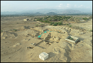
Kalba is a multi-period site situated in the Emirate of Sharjah, United Arab Emirates, on the Gulf of Oman (Figure 2), and dates from the Early Bronze Age to the Iron Age (c. 2500–600 BC). The site's location, close to Wadi Ham, links the eastern coast and the desert through the mountains, making it favourable for exchange.
Aerial photograph of the excavations at Kalba (photograph: Sharjah Archaeology Authority; figure by K. Kamyab).

Nowadays, a small mound of about 50m in diameter and an elevation of about 2.5m is visible. During the Early Bronze Age Umm an-Nar period, a massive sub-circular ‘tower’ construction was positioned on top of the mound (Figure 3) and surrounded by a huge ditch. In general, this area of the site was the focus of building activities, attested by massive constructions that expanded its surface area, until the Iron Age.
Plan showing the excavated architecture and the location of the trenches (plan: Austrian Academy of Sciences, Austrian Archaeological Institute; figure by M. Börner).

Environmental conditions
The site was continuously inhabited for around 2000 years, despite significant local environmental deterioration—part of wider changes resulting from an increasingly drier climate from the third millennium onwards—that is attested by results of the local marine reservoir effect at Kalba. Recent analyses of charcoal used as fuel at the site provide insights into this persistence. Use of mangrove species that grow in fresh or brackish water conditions rather than species related to saltwater conditions indicates that fresh water was available in the vicinity of the site at least between 2500 and 1000 BC (Schwall et al. Reference Schwall2022). The annual monsoon probably brought rain and possibly filled a natural reservoir in the eastern part of the Hajar Mountains. This assumption is supported by the analysis of fish bones from species that live in brackish water (Lidour et al. Reference Lidour, Beech, Eddisford, Phillips, Schwall and Jasim2023). For these reasons, the region around Kalba can be considered an ecological niche at least until the early Iron Age.
Being part of the game: location, mineral resources and craft activities as key factors for prehistoric trade networks
Besides favourable environmental conditions, the geostrategic location of Kalba also offered ideal conditions as a gateway between maritime waterways and land-based caravan routes. Wadi Ham, a geological fault zone that runs to the north-west, seems to have been crucial for the diachronic occupation of the site. It is still a convenient passage for crossing the Hajar Mountains today and enables the exchange of goods with the interior of the south-eastern Arabian Peninsula.
However, it is important to consider the question of which objects or raw materials were brought to Kalba, which were produced and used at the site, and which presumably served as trade goods. All indications point to a special relevance of mineral resources. Excavations have thus far revealed evidence for copper processing, with ore most likely coming from deposits in the nearby Hajar Mountains. Artefacts made of chert, jasper and chalcedony were also found, but such mineral resources are not available in the immediate vicinity of the site (Schwall et al. Reference Schwall2023). In the search for possible deposits, suitable raw material was found beyond the Hajar Mountains on the western foothills at the transition to the desert (Figure 4). Initial geochemical analyses revealed that chert used to produce chipped stone objects was brought to the site from sources in the Buhais mountains, approximately 50km to the west. Mineral resources of the mountains seem to have been an important economic factor for the inhabitants of Kalba in general. This is also demonstrated by stone vessels (Figure 5). The use of local stone sources for their production is evidenced through geological studies and the presence of unfinished stone vessel fragments at the site.
Map showing the location of the sampled raw-material sources (map: Austrian Academy of Sciences, Austrian Archaeological Institute & Leibniz-Zentrum für Archäologie; figure by C. Schwall, M. Börner & M. Brandl).

Fragment of an Umm an-Nar-style stone vessel (KAL21/55/3/1) (3D model: Austrian Academy of Sciences, Austrian Archaeological Institute & Leibniz-Zentrum für Archäologie; figure by M. Börner & C. Schwall).

In addition to occupying a favourable ecological niche, the research results demonstrate the sophisticated and versatile raw-material procurement strategies of a multi-crafting coastal community. Moreover, the participation of Kalba in extended exchange and trade networks is evidenced by a ‘Gulf type’ seal (Figure 6).
‘Gulf type’ seal (KAL23/709/3/1) made of softstone (figure by H. David-Cuny).

This seal type, originally produced in the Dilmun region, can be dated to the end of the third millennium BC (Laursen Reference Laursen2010). The seal depicts a bull and what is possibly a lion in attacking poses. The bull motif, widely recognised on similar seals, is clearly influenced by the iconography found on seals in the Indus Valley. The lion, however, is intriguing as it is not depicted on Indus seals but is rather known as a motif on cylinder seals in the more western Mesopotamian region. Consequently, the motifs presented on the ‘Gulf type’ seal from Kalba appear to be a possible fusion of eastern and western motif traditions within a unique local-seal type on the south-eastern Arabian Peninsula, highlighting the unifying character of this coastal trading site.
Acknowledgements
The investigations were conducted with the authorisation of the Sharjah Archaeology Authority and the Ruler of Sharjah, His Highness Sheikh Dr Sultan bin Muhammad al-Qasimi. Additionally, we are grateful to the Austrian Embassy Abu Dhabi, especially His Excellency ambassador Dr Etienne Berchtold and Dr Andreas Liebmann-Holzmann for their support. For language corrections we are thankful to Dr Aaron M. de Souza.
Funding statement
For funding, we would like to thank the Prehistoric Phenomena research group of the Austrian Archaeological Institute, the Dr Anton Oelzelt-Newin'sche Stiftung of the Austrian Academy of Sciences.


