


Introduction
Reducing inequality is a pressing global challenge, acknowledged in the United Nations Sustainable Development Goals (SDG-10; https://www.un.org/sustainabledevelopment/inequality/), but the widening gap between rich and poor began long before capitalism (e.g. Kohler et al. Reference Kohler2017; Graeber & Wengrow Reference Graeber and Wengrow2021; Green et al. Reference Green2024). The Indus Civilisation (c. 2600–1900 BC) of South Asia is an ideal case study for investigating the early dynamics of inequality. The region was home to some of the world’s first cities (Kenoyer Reference Kenoyer, Nichols and Charlton1997; Possehl Reference Possehl, Feinman and Marcus1998; Menon Reference Menon2008; Wright Reference Wright2010; Petrie Reference Petrie and Clark2013; Ratnagar Reference Ratnagar2016), which developed independently of urbanisation in other parts of the world and thrived at unprecedented scales. Indus cities lacked palaces, ostentatious tombs, exclusionary temples and individual-aggrandising art—direct proxies of ‘elites’ in the past (Green Reference Green2021). A qualitative evaluation of evidence from the Indus Civilisation thus challenges the neoevolutionary theory that inequality was a prerequisite of urbanisation (e.g. Childe Reference Childe1950). But can this challenge be supported quantitatively?
The Gini coefficient is an economic statistic that captures the concentration of a particular variable within a population, and can be used to investigate past inequality (McGuire Reference McGuire1983; Smith Reference Smith1987). Gini coefficients are derived from a Lorenz curve and range from 0 (total equality) to 1 (total inequality). In archaeology, Gini coefficients are commonly calculated using residence areas as a proxy for wealth or income (Kohler & Smith Reference Kohler and Smith2018; Kohler et al. Reference Kohler2025a). Residential disparities do not comprehensively reflect social inequality, but they can reveal differentials in the access to labour and resources among households in archaeological datasets (Ortman et al. Reference Ortman2025) and can thus be used to develop robust comparative studies of past economies (Basri & Lawrence Reference Basri and Lawrence2020; Bogaard et al. Reference Bogaard2025; Kohler et al. Reference Kohler2025b). In this article, we draw on the GINI database (Ortman Reference Ortman2024) to investigate economic inequality at Mohenjo-daro, the Indus Civilisation’s most extensively excavated city (e.g. Jansen Reference Jansen, Parpola and Koskikallio1993a). Our purpose is not to provide a comprehensive account of inequality at Mohenjo-daro—see Green (Reference Green2021) for a detailed review of qualitative evidence for the distribution of wealth and power in the Indus Civilisation. Rather, we ask: does the available quantitative evidence support the claim that economic inequality was constrained at Mohenjo-daro, suggesting that the Indus Civilisation was, indeed, relatively egalitarian?
Background
Mohenjo-daro is situated near the Indus River in Pakistan’s Larkana Plain and consists of mound clusters that were excavated in the early twentieth century (Marshall Reference Marshall1931; Mackay Reference Mackay1938; Wheeler Reference Wheeler1950; Dales et al. Reference Dales1986). These excavations, along with subsequent surface surveys (Jansen Reference Jansen1993b), revealed large non-residential structures that were monumental in scale (e.g. Possehl Reference Possehl2002) and physically accessible to the public (Green Reference Green2018, Reference Green2021). These buildings, together with planned streets and drainage infrastructure (Jansen Reference Jansen1993b), weights and measures (Miller Reference Miller and Abraham2013) and standardised seals and sealings (Green Reference Green2016; Jamison et al. Reference Jamison2023) constituted public goods that benefited the city’s larger community (Green Reference Green2022). Early excavations also revealed hundreds of rectilinear houses (Marshall Reference Marshall1931; Mackay Reference Mackay1938), which were later found to rest upon massive foundation platforms (Jansen Reference Jansen, Parpola and Koskikallio1993a). These elaborate residences had amenities like bathing platforms, second stories and private wells, but elicited surprisingly little attention from archaeologists for a half century. Indeed, Mohenjo-daro’s tangle of walls, doorways, staircases and courtyards (Figures 1 & 2) were imperfectly recorded using early-twentieth-century archaeological methods, leading Dilip Chakrabarti (Reference Chakrabarti, Chakrabarti and Lal2014: 114) to despair that interpretations of the site’s architecture are “nothing but excavators’ attempts to infuse some character into the vast piles of burnt-bricks”.
Mohenjo-daro and its excavation areas (figure by authors; basemap consists of Google Earth Imagery © 2026; inset basemap is from Natural Earth).

A view of DK-G South, facing north-west, from December 2023, highlighting the complexity of the standing architecture at Mohenjo-daro (photograph by Adam S. Green).

Archaeologists were, nonetheless, undeterred. Sarcina (Reference Sarcina1979) defines a Mohenjo-daro residence as the rooms accessible to a single courtyard, identifying common residence templates. Wilkins (Reference Wilkins, Franke-Voct and Weisshar2005) observes that the structure walls in Mohenjo-daro’s later levels were thinner than in earlier levels, attributing this pattern to the ‘decline’ of its urban fabric. Cork (Reference Cork2011) notes heterogeneity in structure size, and Vidale (Reference Vidale2010) argues that Mohenjo-daro’s larger residences could have served as palaces for a heterarchical elite. Conversely, Green (Reference Green2021) notes that none of the larger houses at Mohenjo-daro included the administrative features archaeologists associate with a seat of authority, seeing instead potential for diachronic study. Using a geographical information systems (GIS) approach to differentiate chronological phases in the DK-G South Area, the portion of the site excavated using datums to record the depth of building periods (Mackay Reference Mackay1938: xvi), they note that the city’s residences became more uniform and more closely aligned with the city’s streets over time (Figure 3; Green Reference Green2018).
Diachronic change in architectural plans in DK-G South. The bottom image depicts the earliest structure plans recovered from the area, and the top depicts the later structure plans. Map prepared using data from Mackay (Reference Mackay1938) using QGIS v.3.42 (figure by authors; basemap consists of Google Earth Imagery © 2026).

Mohenjo-daro is critical to debates about the Indus Civilisation’s political economy. Indus archaeologists spent the later twentieth century asking whether neoevolutionary categories, which define the ‘state’ as the socially stratified culmination of social evolution (e.g. Trigger Reference Trigger2003), fit the evidence from the Indus. Some scholars argued that it did not; the Indus was, rather, a complex chiefdom or a non-state (Fairservis Reference Fairservis and Lamberg-Karlovsky1989; Possehl Reference Possehl, Feinman and Marcus1998). Others countered that it was clearly so complex that it was ‘state-level’, and it was thus safe to infer the presence of elites even when direct evidence was absent (Kenoyer Reference Kenoyer, Nichols and Charlton1997; Ratnagar Reference Ratnagar2016). As this debate continued, the ontology that the argument relied on crumbled. Archaeologists working in other parts of the world found that many large-scale societies lacked evidence for stratification (McIntosh Reference McIntosh2005; Yoffee Reference Yoffee2005; Jennings Reference Jennings2016; Graeber & Wengrow Reference Graeber and Wengrow2021; Feinman et al. Reference Feinman2025), and it became clear that the Indus Civilisation produced urban forms and systems of labour organisation that contrasted with other early urban societies (Menon Reference Menon2008; Eltsov Reference Eltsov, Osada and Uesugi2009). Power was more evenly distributed—better described as heterarchical (Wright Reference Wright2010; Vidale Reference Vidale2018) or polycentric (Petrie Reference Petrie and Clark2013), than hierarchical. These patterns led Green (Reference Green2021) to call for an end to the assumption that there were elites in the Indus Civilisation, and to instead work towards a better understanding of its evident egalitarianism. Smith (Reference Smith2022) undertook an initial quantitative assessment of egalitarianism using burial data from Kalibangan and other Indus settlements, finding lower levels in the Indus Civilisation than in Mesopotamia. Green and colleagues (Reference Green2024) argue that Thomas Piketty’s (Reference Piketty2014) finding that high economic growth can mitigate inequality may help explain the pattern evident at Mohenjo-daro, and indeed at many other early cities, where direct evidence of inequality is often limited and ambiguous.
Understanding the long-term dynamics of inequality is an erstwhile interest in archaeology (Flannery & Marcus Reference Flannery and Marcus2012). Frustrated by the same simplistic neoevolutionary categories that hindered debates about Indus urbanism, some archaeologists have rejected the idea of an ‘origin’ of inequality (Moreau Reference Moreau2020; Graeber & Wengrow Reference Graeber and Wengrow2021). After all, some form of inequality appears in all societies. However, it is important to avoid glossing processes as distinct as Bronze Age retainer sacrifice and the differential deposition of beads in Palaeolithic burials simply as ‘inequality’. There have, in fact, been major changes in the capacity of some individuals to claim the labour of others (Green et al. Reference Green2024), and archaeologists need robust methods and theories to contend with those changes.
Kohler and Smith (Reference Kohler and Smith2018) advocate a large-scale comparative approach that uses the Gini coefficient to assess the concentration of residence areas in past societies. Gini coefficients of residential disparity are not perfect proxies of inequality (Oka et al. Reference Oka, Kohler and Smith2018; Kay et al. Reference Kay2022; Hutson et al. Reference Hutson2023; Green et al. Reference Green2024), for example struggling to account for people without residences (e.g. Simelius Reference Simelius2022; Fochesato & Bowles Reference Fochesato and Bowles2024). While studies of residential disparity do not reveal a comprehensive view of inequality within a past society, they do reflect some salient economic aspects of inequality. They also allow archaeologists to develop robust quantitative analyses across contexts or time periods, testing existing ideas or raising new questions.
The Global Dynamics of Inequality (GINI) project brought together regional experts to build a global database of past residences (Bogaard et al. Reference Bogaard2024; Kohler et al. Reference Kohler2025a). Analyses of the GINI database reveal that the potential for economic inequality increased through time, but that egalitarianism was often persistent, challenging simplistic narratives (Feinman et al. Reference Feinman2025). They also reveal differences in economic inequality at different scales within the same societies (Crema et al. Reference Crema2025). Thompson and colleagues (Reference Thompson2025) found that residential disparities within neighbourhoods tended to be lower than across the cities in which the neighbourhoods were located. In this way, they may have reduced ‘perceived’ inequality, contributing to greater tolerance of higher levels of residential disparity at the scale of the city.
Ortman and colleagues (Reference Ortman2025) argue that residence areas could contribute to broader analyses of past economies. Gini-based studies assume residence area reflects income or wealth, an assumption that also indicates that the mean of all residence areas should represent mean income or wealth within a particular sample. Changes in average residence area therefore reflect changes in economic growth. As such, changes in the mean log of residence area are a proxy for productivity. Comparing these changes across the GINI database suggests that, initially, periods of high productivity incurred low levels of inequality, but that, over centuries, inequality eventually rose to catch up (Green et al. Reference Green2025; Kohler et al. Reference Kohler2025c).
Methods
Does the absence of qualitative proxies for elites at Mohenjo-daro correspond to a low quantitative level of economic inequality? We addressed this question by creating a GIS using early excavation data, georeferencing and polygonising residence plans, then calculating Gini coefficients both for areas, subareas and phases.
Marshall (Reference Marshall1931) directed the excavation of five ‘areas’ at Mohenjo-daro: HR, VS, L, SD and DK. Some areas were subdivided into ‘sections’ (Figure 1). Marshall’s excavations dated buildings according to their construction quality. Early Period structures were rudimentary, Intermediate Period structures well-organised and well-built, and Late Period structures degraded and collapsing. The resulting plans thus incorporate chronological inaccuracies, muddling buildings from different periods. Plans from these initial excavations were scanned and georeferenced using QGIS v.3.42 (QGIS Development Team 2025). These structures were vectorised and labelled using groupings identified in the original report. Unpublished plans from a later excavation of structures in the area labelled ‘Moneer’ were also scanned and vectorised (Figure 1), following the house assignments provided by a later revisitation project (Jansen Reference Jansen, Lal and Gupta1984).
The second series of early excavations at Mohenjo-daro were more temporally accurate. To investigate change through time, Mackay (Reference Mackay1938) used fixed datums to clarify the three-period chronology established by Marshall’s team, recording the depth of each structure foundation. The results are less precise than today’s single-context stratigraphic excavations, but they were advanced for the time, yielding a relative structural sequence in DK-G South. We georeferenced these plans and created polygons representing the residences identified in the original report (Figure 4). We used absolute dates for the occupation of Mohenjo-daro (c. 2500–1900 BC), established in later reassessments (Jansen Reference Jansen, Parpola and Koskikallio1993a), to approximate dates for each phase by dividing the total period of occupation by the number of relative phases, creating an valuable, if imperfect, tool for assembling a time series.
Residences identified by early excavators in area HR. Map prepared using data from Marshall (Reference Marshall1931) and QGIS v. 3.42 (figure by authors).

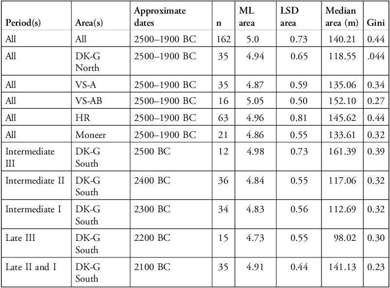
The resulting residence areas have previously been incorporated into large-scale cross-regional studies (e.g. Thompson et al. Reference Thompson2025), but here we use these data to investigate inequality in the Indus Civilisation specifically. A total of 309 residence areas were used to calculate Gini coefficients for Mohenjo-daro in the GINI database (Ortman Reference Ortman2024). The calculations were carried out as part of the GINI project using the DescTools package (Signorell Reference Signorell2023) in R (R Core Team 2024), providing Gini coefficients for each group of contemporaneous houses at a confidence level of 0.80 (Ortman Reference Ortman2024). Calculations were also carried out for each subarea (Thompson et al. Reference Thompson2025), and for each period revealed by Mackay’s team in DK-G South. These were assigned to a century that approximates the inferred chronology. The log of mean residence area, its standard deviation and median residence area were also calculated for each spatial and temporal grouping.
Results and discussion
Overall residential disparity at Mohenjo-daro yields a Gini coefficient of 0.44 (see Table 1). In the GINI database, sites known to exhibit qualitative evidence for stratification like palaces or exclusionary temples have high Gini coefficients, such as the Ancient Greek site of Knossos, which has a Gini coefficient of 0.86, and the Classical Maya site of Palenque, which has a Gini coefficient of 0.75 (Kohler et al. Reference Kohler2025a). Mohenjo-daro’s Gini coefficient is well below these values, and below that of contemporaneous cities in West Asia: Ur and Ugarit both score >0.6—high with respect to the GINI database. Mohenjo-daro was thus far less unequal than neoevolutionary theory predicts.
Gini coefficients of residential disparity at Mohenjo-daro, alongside measurements of residence area and sample information.

These calculations were carried out as part of the GINI project. ML: mean log; LSD: log standard deviation.
Yet, is it reasonable to assert that a Gini coefficient of 0.44 is ‘egalitarian’? A Gini coefficient of 0.44 is double that of some early societies that many archaeologists would consider egalitarian, such as the Neolithic settlements included in the GINI database, where residential disparities rarely exceed a Gini coefficient of 0.2 (Kerig et al. Reference Kerig2025). Mohenjo-daro was an expansive city, and its citizens engaged in diverse activities, inventing new technologies and constructing a large and varied built environment. Does such heterogeneity in the built environment require similar levels of heterogeneity in residential spaces?
While it may be tempting to write off the discrepancy between Mohenjo-daro and other egalitarian Neolithic settlements as a limitation of comparing very different societies, disaggregating Mohenjo-daro’s overall Gini coefficient reveals a more interesting story. There is considerable variability in residential disparity at Mohenjo-daro. HR and DK-G North mirror the site’s overall Gini coefficient of 0.44. Both subareas include structures that may not have been residences, like Block 19 in DK-G North, which may have been a second Great Bath (Mackay Reference Mackay1938: 151), or Block 5 in HR, which includes 16 small structures that may have been ‘shops’ (Marshall Reference Marshall1931: 204). In sections where no non-residential structures have been identified, Gini coefficients are lower. The subareas of VS produce Gini coefficients of 0.34 and 0.27, while Moneer has a Gini coefficient of 0.32, a pattern that may result from the lack of public structures, or may support the argument that urban populations create neighbourhoods with lower perceived inequality (Thompson et al. Reference Thompson2025). These ambiguities are difficult to resolve, as these areas of the settlement must be dated using Marshall’s (Reference Marshall1931) periodisation.
A more provocative pattern emerges from DK-G South, where we can differentiate periods. Here, we find that the site’s most extensive residences are also its earliest, with the median residence area of the Intermediate III Period (c. 2500 BC) measuring 161.39m2. These large structures raise the Gini coefficient of the period close to the site’s overall figure (0.39, versus 0.44).
However, the Gini coefficient declined over time in this subarea (Figure 5). By the Late II and I periods (c. 2100 BC), the Gini coefficient was only 0.23, close to that of other egalitarian societies. While the earliest residential disparities at Mohenjo-daro were moderate, if lower than those found in other early urban societies, they reduced in each subsequent period (Figure 4). As excavations carried out in other areas mingle structures from different periods, it is likely that larger houses from earlier periods in areas other than DK-G South pull the site’s aggregated Gini coefficient upward. It can only be presumed that this trend extends across the whole site, perhaps explaining why the Gini coefficients of VS and Moneer are so much lower than the site as a whole, or indicating that Mohenjo-daro’s citizens took care to constrain perceived inequality as occurred in other early cities (Thompson et al. Reference Thompson2025). Future work could evaluate these positions by revisiting structural chronologies outside of DK-G South.
Trajectory of Gini coefficients in DK-G South. The confidence interval for the overall time series is shown in grey and the central tendency for each period sample at the 0.80 confidence interval is also shown at each point (figure by authors).

If Mohenjo-daro did not begin its existence as a settlement without residential disparity, but became more egalitarian over time, how did this transformation occur? Many archaeologists argue that collective governance—that is, the inclusion of public voice, distribution of political power and provisioning of public goods—was central to the development of many early societies (Blanton et al. Reference Blanton2021; Feinman et al. Reference Feinman2025). At Mohenjo-daro, residential disparity declined as more structures were built in alignment with the city’s streets. This co-occurrence suggests that the decisions that yielded civic amenities accompanied those that ensured the more equitable distribution of residence area, even if we do not know exactly what those decisions were. Perhaps the same governance that ensured the city’s large non-residential buildings were built and its drainage system was drained constrained the unequal distribution of residential space.
Green (Reference Green2018, Reference Green2022) argues that Mohenjo-daro had ‘deliberative spaces’ where people came together to govern the city, channelling resources towards ‘public goods’ that benefited the population as a whole. Governance is also apparent in the wider artefactual record. Indus communities adopted a standardised system of weights and measures, equipping communities across the entire region with tools for establishing commensurate units of mass (Kenoyer Reference Kenoyer, Morley and Renfrew2010; Miller Reference Miller and Abraham2013). They also shared protocols for making Indus seals, small stone stamps that likely facilitated exchange (Green Reference Green2016; Frenez Reference Frenez2023, Reference Frenez2024). Seals and sealings are among the first technologies used to monitor credit and debt, and it is telling that at Mohenjo-daro, seals were typically recovered from residences, not temples or palaces, like their counterparts in Mesopotamia (Green Reference Green2020). The power to govern exchange was distributed, not monopolised, preventing a single group from dominating access to resources, and potentially providing a powerful levelling mechanism.
This possibility that Mohenjo-daro’s egalitarianism was an outcome of governance and not an accident of emergence has implications for broader debates about inequality. A core theory in development economics is that economic growth increases inequality, but that growth continues as inequality levelled off (Kuznets Reference Kuznets1955). This theory underlies Piketty’s (Reference Piketty2014) investigation of the history of capitalist economies, which found the degree to which returns on capital outstrip economic growth determines how far inequality can rise. An analogous association between economic growth and inequality is apparent in the archaeological record—high-growth cities had lower inequality than low-growth citadels (Green et al. Reference Green2024). This association raises the question: does economic growth lower inequality, or does lower inequality drive economic growth?
At Mohenjo-daro, declining residential disparity coincided with increasing residence area. In DK-G South, the most extensive residences were the earliest. Median residence area initially dropped, declining to just 98.02m2 in the Late III Period (c. 2200 BC), as the Gini coefficient declined from the Intermediate Period. However, when the Gini coefficient drops to an egalitarian 0.23, median residence area rebounds, reaching 141.13m2. This value is below that of the earliest period, however, the log standard deviation of residence area is also much lower (0.44, versus 0.73), and the sample size is much greater (35, versus 12). Moreover, in VS Section AB, where the Gini coefficient is just 0.27, median residence area is highest (152.10 m2). The suggested positive relationship between productivity and egalitarianism at Mohenjo-daro is not statistically robust (see the R-code in the online supplementary material (OSM)), as it relies on a fleetingly small number of data points and the earliest structures at the site are quite extensive. Interestingly, Possehl (Reference Possehl2002: 237) notes that there is more evidence for craft production in the Late Period, providing additional support for an upward trajectory in productivity. Why might Mohenjo-daro have experienced a boost to its productivity around the same time as its residential disparity was lowest? Perhaps the collective governance that lowered the city’s inequality played a role in increasing the neighbourhood’s prosperity—a speculation to be sure, but one worthy of future investigation.
There is also scope for improving the definition of a ‘residence’ at Mohenjo-daro. In this article we have grouped rooms that excavators identified as residences. However, as neighbourhoods were exposed, excavators were confronted with a complex tangle of walls, staircases, door-jambs and windows, and there is plenty of room to critique and reinterpret their groupings (e.g. Sarcina Reference Sarcina1979; Jansen Reference Jansen, Parpola and Koskikallio1993a; Vidale Reference Vidale2010; Green Reference Green2018). There are likely building phases in the Mohenjo-daro data that are obscured by the early reports, and future studies that combine the analysis of the site’s standing architecture with field notes and other archival sources of legacy data could reveal better groupings. Such new thinking about old datasets is the aim of the M-LAB project based at the Laboratory for Integrative Archaeological Visualization and Heritage at the Pratt Institute (https://liavh.org/m-lab/). As such work yields new and nuanced interpretations, it will be possible to recalculate representative metrics from the early city of Mohenjo-daro, further advancing our understanding of inequality and economic growth.
It is important to reiterate that residential disparity is not a perfect proxy of inequality, nor are changes in residence area an ideal proxy for productivity. Both only indirectly reflect the full range of social inequalities that occurred in past societies. As many critics have noted, such inequalities manifest across a range of different materials, and a wealthy person may very well not invest their resources in a bigger house. Inequality, moreover, often cleaves along the lines of other identities, like gender, kinship or ethnicity. Future work on the Indus Civilisation and elsewhere should incorporate additional metrics of wellbeing into analyses of inequality (e.g. Munson et al. Reference Munson2023). Adapting tools for measuring the material impacts of contemporary economies to the archaeological record could reveal trends that differ from those indicated by comparing changes in residence area (e.g. Green & Mair Reference Green and Mair2026).
Conclusion
Archaeological evidence from Mohenjo-daro provides an essential dataset for investigating the relationship between urbanisation and inequality. In this article, we drew on the GINI database to investigate whether quantitative analysis supports the claim that Mohenjo-daro was, indeed, relatively egalitarian. The overall level of economic inequality at Mohenjo-daro is lower than comparable metrics from contemporaneous early cities—but more importantly—economic inequality declined over time. Concurrently, intense development occurred along Mohenjo-daro’s streets, suggesting a connection between the reduction of inequality and the governance of the city. This finding supports the claim that collective governance exerted a powerful force on the long-term trajectory of inequality at Mohenjo-daro. It also resonates with broader arguments in inequality studies, which hold that, to reduce inequalities today, governments must take action to ensure equitable access to resources.
Acknowledgements
We thank the organisers of the Global Dynamics of Inequality Project (GINI) for convening the working group that prompted us to assemble these data, especially Tim Kohler, Amy Bogaard and Scott Ortman. We also thank Amy Thompson and Dan Lawrence for discussions that helped improve the article, and our departments at the universities of York and Cambridge for supporting our participation in the project. We are also grateful to the Coalition for Archaeological Synthesis, Sante Fe Institute, and GINI project participants. Each of these communities provided a vital sounding board for the argument developed in this article. This work has benefited from conversations with Uzma Rizvi, J. Greg Smith, Sara Eichner and other members of the Laboratory for Integrative Archaeological Visualization and Heritage team, whose work is helping advance our understanding of Mohenjo-daro’s legacy dataset. We further acknowledge the efforts of the two anonymous peer reviewers for their feedback and critique. Finally, we thank Toby C. Wilkinson, Darryl Wilkinson, Tom Leppard, Nancy Highcock and Gary Feinman for an ongoing conversation about the archaeology of inequality that has strengthened this work.
Funding
The GINI project was funded by the National Science Foundation (grant no. BCS-2122123) and supported by the Coalition for Archaeological Synthesis (CfAS, http://www.archsynth.org/) and the Center for Collaborative Synthesis in Archaeology (CCSA, https://ibsweb.colorado.edu/archaeology/). The Santa Fe Institute generously hosted the GINI working groups.
Online supplementary material (OSM)
To view supplementary material for this article, please visit https://doi.org/10.15184/aqy.2026.10359 and select the supplementary materials tab.


 Open access