

Introduction
The U.S. Geological Survey is currently analyzing Landsat imagery of the Antarctic coastline from two different time periods: Landsat 1, 2 and 3 data from the early 1970s and Landsat 4 and 5 data from the mid-1980s/carly 1990s. The project objectives are: (a) to establish an accurate baseline dataset that identifies and maps the glaciological features and ice-front location (Williams and others, 1995; Swithinbank and others, 1997); (b) to compile a comprehensive inventory of named and unnamed glaciers; (c) to measure velocities of outlet glaciers, ice streams and ice shelves wherever possible; and (d) to analyze coastline change between the earlier and later images.
This paper reports results from the analysis of Landsat imagery covering the Marie Byrd Land and Ellsworth Land coasts (about 81-158° W) (Fig. 1), briefly discusses ice velocities (objective 3) but focuses on the analysis of coastline change (objective 4). Ice velocities are discussed in more detail in Rosanova and others (1998).
Landsat data make it possible to identify, locate and date coastal features. Once an accurate baseline is established, it can be used to determine and analyze changes along the coastline. This type of research is important because extensive or long-duration changes along the coastline may indicate a regional response to changes in global climate.
As part of the analysis of coastline change, we have used ice velocities and ice thickness, where available, to estimate iceberg calving. The estimates have been compared to determine the relative dynamics of the coastline which are particularly relevant to the stability of the West Antarctic ice sheet. Dynamic glaciological change is occurring in the Antarctic Peninsula with significant recession of the Wordie and Larsen Ice Shelves (Doake and Vaughan, 1991; Skvarca, 1993,1994; Rott and others, 1996; Vaughan and Doake, 1996). Indications of change are also visible in Wilkins and George VI lec Shelves (Lucchitta and Rosanova, 1998). A key question is whether less obvious, but still important, changes are occurring along other parts of the Antarctic coastline.
Recent work byjenkins and others (1997) has shown that as much as 12 m a-1 bottom melt is occurring beneath Pine Island Glacier. Considering this amount of bottom melt in the Marie Byrd Land area, and considerable changes in other areas of the continent, it is worth examining the Marie Byrd Land and Ellsworth Land sections of the Antarctic coastline for signs of change — retreat or advance.
Methodology
Analysis of Landsat imagery
The analysis of Landsat imagery and detailed mapping of glaciological features and ice-front locations was done using a combination of manual and digital techniques as described in Williams and others (1995).
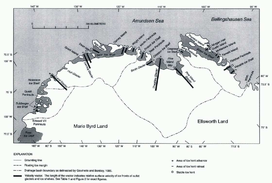
Sketch map of the Marie Byrd Land and Ellsworth Land coasts,West Antarctica, showing geographic features, velocity vectors of outlet glaciers and ice shelves, and areas of ice-front advance or retreat.
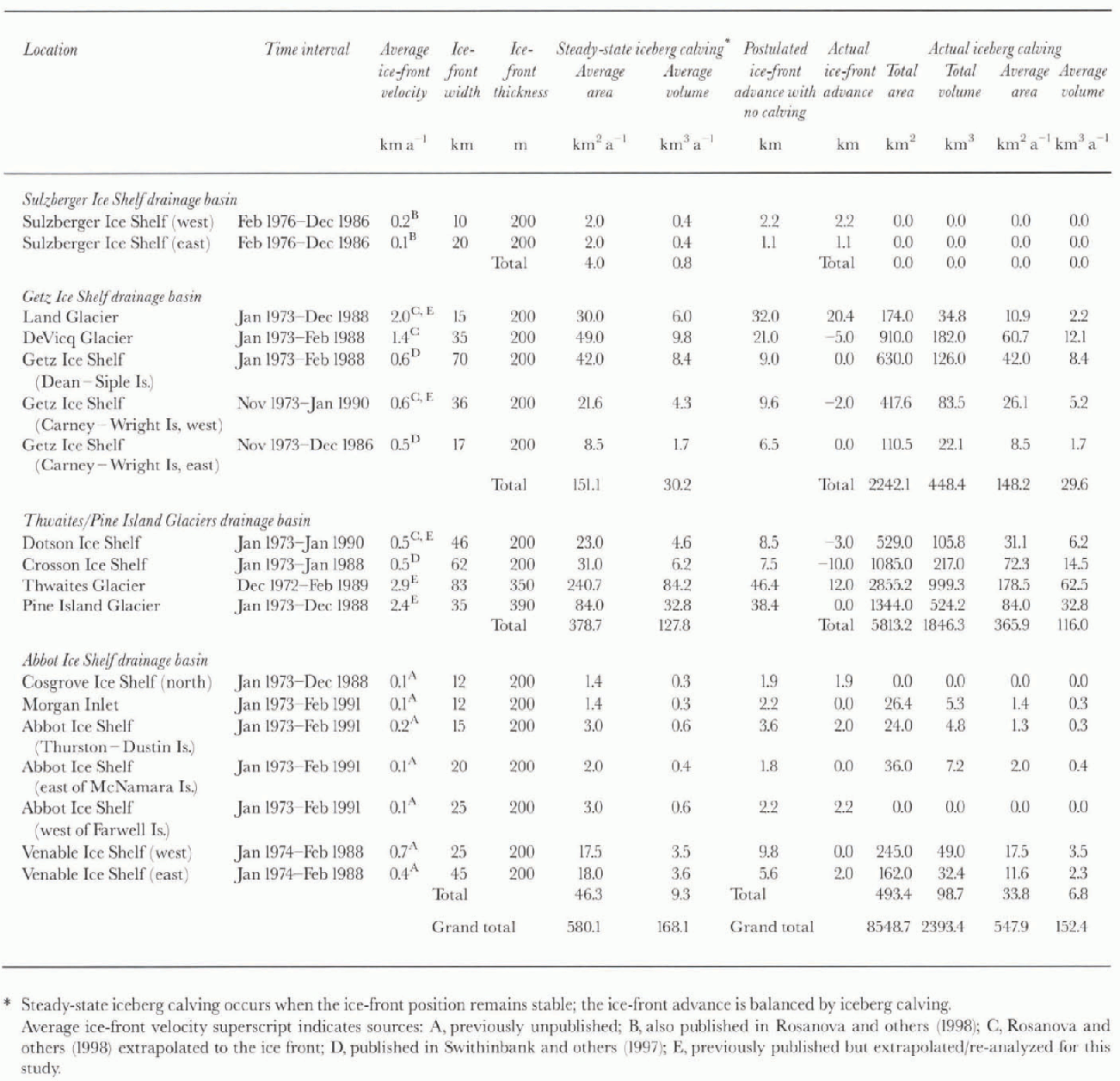
Ice front velocity, ice-front change and iceberg calving based on analysis of Landsat images, Marie Byrd Land and Ellsworth Land, West Antarctica
Ice-velocity measurements
Since the 1980s, measurements of ice velocities along the Marie Byrd Land and Ellsworth Land coasts using satellite imagery have been done by several authors (MacDonald and others, 1990; Ferrigno and others, 1993; Lucchitta and others, 1993, 1994, 1995; Rosanova and others, 1998). The method has evolved from early manual measurements to an interactive method, in which crevasse patterns are tracked visually on images (Lucchitta and others, 1993), and an autocorrelation method developed by Bindschadler and Scambos (1991) and Scambos and others (1992). For this paper, and the paper by Rosanova and others (1998), new measurements were made and earlier measurements redone using the autocorrelation program that produced a higher density of velocity vectors and, in some cases, increased accuracy.
Ice-front positions
The ice-front positions at the two time periods of the Landsat images were plotted and their differences were measured manually to determine the amount of coastline advance or retreat. Then “steady-state” and “actual” calving rates were calculated. Steady-state calving occurs when the ice-front advance is balanced by calving and the ice-front position remains stable. The steady-state iceberg-calving rate was calculated by visualizing a gate near each floating ice front. The width across this gate was measured and the value multiplied by the average annual ice-front velocity to determine the average annual iceberg-calving rate for steady-state conditions. Using known or assumed ice-front thicknesses, we calculated the volume of the steady-state average annual iceberg production. Ice-front thickness is known for Pine Island Glacier (Jenkins and others, 1997). Thwaites Glacier
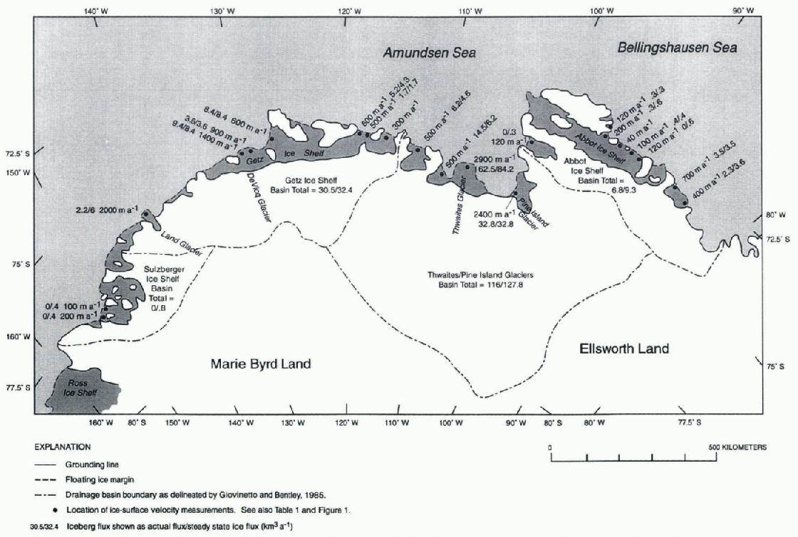
Location and magnitude of ice-surface velocities and iceberg flux calculatedfor Marie Byrd Land and Ellsworth Land coasts based on analysis of Landsat imagery from the early 1970s and mid-1980s/early 1990s. Flux is shown actual/steady state. If the actualflux is less than the steady-stateßux, the icefront has advanced on the average, and vice versa.
Tongue has a few radio-echo sounding measurements that were projected to the ice front. For the rest of the ice fronts, we assigned a thickness of 200 m as being typical for this type of floating ice. The actual iceberg-calving rate, during the interval of the Landsat images, was calculated by determining the total area and volume lost to calving between the last-observed position of the ice front and the position predicted if no calving had occurred, and by dividing the area and volume by the number of years in the time interval.
Accuracy
There may be some uncertainty in our calculations of ice-front velocities, ice-front advance, ice-front width and ice-front thicknesses. in the velocity measurements, errors depend on the co-registration of the imagery and the accuracy of the measured displacement, which in turn depends on the speed of the ice and the time interval between the Landsat images. Under optimum conditions, measurement errors in displacement can be as small as ±0.02 km, but for most image pairs, where registration of features is accurate only to two or three pixels, the accuracy is ±0.1 km (Lucchitta and others, 1993; Rosanova and others, 1998). This translates to a maximum error in our calculations of ±9% with slow-moving ice measured over a shorter period of time, such as the western part of Sulzberger Ice Shelf that moved 1.1 km in almost 11 years (Table 1). The error is reduced with ice moving faster over a longer period of time, to a minimum of ± 0.2% at Thwaites Glacier which moved 46.4km in 16 years.
The ice-front advance measurements were averaged across each floating ice front and can have as much uncertainty as ±0.5 km when the ice front has advanced or retreated, or 1-30% in ice-front change depending on the amount of movement. The ice-front width measurements were rounded to the nearest kilometer and are therefore accurate to ±0.5 km. This adds an uncertainty of 1-5%. Ice-front thickness estimates introduce the largest error into our calculations. Where measurements have been made, the error is minimal, but in most areas where thickness was estimated the error can be as much as ±50%. Although the icebcrg-calving-volumc estimates have a large degree of uncertainty, the figures are useful in overall ice-loss comparisons along the coastline and in indicating which parts of the coastline are most dynamic.
Outlet-Glacier, Ice-Stream and Ice-Shelf Velocities
Floating ice-front velocities on the Marie Byrd Land and Ellsworth Land coasts range from the rapid velocities of outlet glaciers such as Thwaites, Pine Island, Land and DeVicq Glaciers to those of the slower-moving ice shelves, such as Sulzberger Ice Shelf. Table 1 and Figure 2 show the distribu-tion and values of the calculated ice-surface velocities. On each glacier, velocity increases downstream from the grounding line to the ice front. The velocities listed in Table 1 and discussed in the text are those measured at or projected to the ice front.
The ice velocities in Table 1 have not been calculated over exactly the same time interval as that over which the ice-front change measurements have been made. The ice-front change was measured over the longest possible time-span allowed by the Landsat imagery. Velocities were calculated over a very similar period, but using imagery that was optimum for the velocity-measurement technique. in order to remain with in the time-frame of the Landsat data, the latest velocity measurements available for theThwaites and Pine Island Glaciers were not used. The velocity value for Thwaites Glacier (2.9 km a-1 ) is from Ferrigno and others (1993), extrapolated to the ice front. That used for Pine Island Glacier (2.4 km a) is a median figure between the velocity calculated using 1973-75 Landsat data (2.1 km a-1 from Crabtree and Doake, 1982; 2.2 km a-1 from Williams and others, 1982; 2.4 km a-1 from Lindstrom and Tyler, 1984) and the velocity calculated using 1992-94 ERS-1 synthetic aperture radar data (2.6 km a-1 from Lucchitta and others, 1995; 2.6 km a-1 from Jenkins and others, 1997).
Coastal Change
In the past 12 years, several major changes have occurred at Larsen, Wordie, Filchner and Ross Ice Shelves, and near Thwaites Glacier that have significantly changed the Antarctic coastline (Ferrigno and Gould, 1987; Doake and Vaughan, 1991; Skvarca, 1993, 1994; Rott and others, 1996; Vaughan and Doake, 1996). Some of these events, such as those at the Filchner and Ross Ice Shelves, may be normal cyclical calving events, but others, such as at the Larsen and Wordie Ice Shelves, appear to be the result of a change in global or regional climate conditions.
In the following sections, we examine the coastal changes that have occurred along the Marie Byrd Land and Ellsworth Land coasts from the early 1970s to the mid-1980s/early 1990s. in order to understand the glaciological dynamics in relation to the size and extent of the major drainage basins, we have examined the coastal areas using the basins as delineated by Giovinetto and Bentley (1985).
Sulzberger Ice Shelf drainage basin (146—158 W)
The Sulzberger Ice Shelf drainage basin has an area of 55 x 103 km2 (Gio\ 'inetto and Bentley, 1985) and is the smallest and least dynamic glaciologically in the study area. The west-east distance along the coast is approximately 350 km. The ice front is composed mainly of segments of the Sulzberger and Nickerson Ice Shelves interspersed with the ice walls of Edward VII and Guest Peninsulas and several islands (Fig. 1). Comparison of Landsat imagery dated February 1976 and December 1986, almost 11 years apart, shows a remarkably similar ice front. Most features present in 1976 are still present in 1986. Except for the advance of two small glacier tongues on the west side of Sulzberger Bay, there is no conspicuous change, although measurement indicates the entire floating ice front has advanced slightly. the lack of noticeable change can be explained by two factors. The first is that ice velocities measured for Sulzberger Ire Shelf are relatively slow, 200 ma-1 for the western part of the ice shelf and 100ma-1 for the eastern part. These ice velocities caused the ice front to advance about 2 km on the west and about I km on the east during this time interval. Another reason for the small amount of change is the prevalence of fast ice here. This reduces the amount of calving by protecting the ice front from wind and wave action and tends to hold the ice together even when badly crevassed. Table 1 lists the results of the coastal-change analysis of the Sulzberger Ice Shelf drainage basin. The advance in the ice front is small, and there was no measurable iceberg flux during the study interval.
Getz Ice Shelf drainage basin (114-146° W)
The Getz Ice Shelf drainage basin has an area of 142 × 10a km2 (Giovinetto and Bentley, 1985). It extends almost 1000 km west-east, but an average of only about 250 km to the south. The western third of the ice front is composed of a small segment of Nickerson Ice Shelf, Land and Hull Glaciers and several sections of constantly calving ice walls. The eastern part is dominated by Getz Ice Shelf for more than 550 km. The floating ice front is interspersed with the grounded-ice walls of Siple, Carney and Wright Islands and Martin Peninsula and several smaller islands and peninsulas. The fast-moving DeVicq Glacier flows through the western part of Getz Ice Shelf (Fig. 1).
Comparison of Landsat imagery from 1973-90 (see Table 1 for exact dates) shows a fairly similar coastline. in the western part of the area, clouds obscure some of the features, but it is possible to tell from the fracture pattern of its glacier tongue that Land Glacier advanced about 32 km between January 1973 and December 1988. of this total advance, 11.6 km (about 174 km2) calved from the seaward end. The 32 km advance during the 16 year interval corresponds to the average frontal velocity of about 2.0 km a-1.From Land Glacier to Grant Island the coastline is characterized by constantly but slowly calving ice walls and some outlet glaciers. Just west of Grant Island the ice front has advanced as much as 5 km, but no velocity information is available to estimate the amount of ice that calved here.
The excellent Landsat coverage of the eastern half of Marie Byrd Land enabled a comprehensive glaciological analysis of most sections of this coastline. From Grant Island to Dean Island, the 82 km ice front consists of Getz Ice Shelf, with DeViccj Glacier and some unnamed adjacent glaciers flowing through the ice shelf. The glacier-flow features are diffuse and it is difficult to separate one glacier from another. Here we consider the first 30 km of the ice front east of Grant Island to be DeVicq Glacier, and the remaining 52 km to be composed of intermingled unnamed glaciers and the Getz Ice Shelf. With Landsat coverage of the westernmost 10 km of DeVicq Glacier from only one time period, we cannot discuss ice-front change in this area. Along the next 35 km, the ice front receded an average of 5 km betweenjanuary 1973 and February 1988, representing calving of about 910 km2 (Table 1). For the last 37 km, the ice front advanced 3-12 km (Williams and others, 1995). The advance is close to what would be expected if no calving had occurred, but there is insufficient velocity data to discuss iceberg calving in this area accurately.
Between Dean Island and Siple Island, there was a small advance of as much as 2.5 km of the western part of the ice front and a slightly larger retreat, as much as 3 km, of the central part. The eastern part is basically in the same location. in total, this section of the coast has remained stable. West of Carney Island, a small part of Getz Ice Shelf receded 1-5 km between December 1972 and February 1988. Lack of velocity measurements on the ice shelf between Siple and Carney Islands prevents analysis here. East of Carney Island to Wright Island, the ice front either remained in the same position on the two Landsat images or receded an average of about 1 km, essentially remaining stable. Between Wright Island and Martin Peninsula, Landsat imagery was available for velocity measurements, but the ice front was obscured during one time period so it was impossible to analyze change here.
Table 1 gives the results of the coastal-change analysis for this drainage basin. Although there has been ice-front advance in some sections and retreat in others, comparison of the steady-stale and actual calving figures shows that actual calving was slightly less than the steady-state condition, indicating a small net advance of the floating ice front.
Thwaites/Pine Island Glaciers drainage basin (103-114° W)
The Thwaites/Pine Island Glaciers basin is the largest (411 ×l03km2; Giovinetto and Bentley, 1985) and most glaciologically dynamic drainage basin in the study area. The basin is narrow at the coast (350 km across) but widens and then tapers as it extends more than 600 km inland, beyond 80° S. The ice front includes Dotson and Crosson Ice Shelves and Martin and Bear Peninsulas but is dominated by Thwaites and Pine Island Glaciers, two of the fastest-flowing outlet glaciers in Antarctica. With a drainage basin almost as large as that of Ice Streams A, B, C and D combined (497 × IO3 km2; Giovinetto and Bentley, 1985) and with much faster ice velocities, this basin has at least as much potential for draining the West Antarctic ice sheet as the ice streams.
Comparison of Landsat imagery from December 1972 to January 1990 shows that although the 46 km wide front of Dot son Ice Shelf receded an average of 3 km, the largest changes have occurred in the Thwaites Glacier and adjacent Crosson Ice Shelf areas. The 62 km wide front of Crosson Ice Shelf, that drains Smith Glacier, receded 5-13 km (Williams and others, 1995), averaging approximately 10 km betweenjanuary 1973 and January 1988. The irregular 83 km wide terminus of Thwaites Glacier Tongue advanced about 12 km between December 1972 and February 1989 (Williams and others, 1995). Thwaites Glacier is the most important outlet glacier in the study area. It has the highest ice-front velocity (2.9 km a-1; Table 1) and the widest calving front (83 km). According to our measurements, the glacier calved more than 2800 km2 during the study period. An ice-front thickness of 350 m, interpolated from Scott Polar Research Institute radio-echo sounding data (Swithinbank, 1988), yielded a total iceberg flux of approximately 1000 km3. However, the calculation of ice loss here is complicated by the substantial changes that took place between 1972 and 1989. in 1972, Thwaites Iceberg Tongue (7000 km2) was located just north of and adjacent to Thwaites Glacier Tongue. Its presence may have slowed the velocity of the glacier and trapped much of the ice that would have calved from the glacier tongue. in 1986, the ice at the southern end of Thwaites Iceberg Tongue began to break up (Ferrigno and Gould, 1987). Over the next several years, the iceberg tongue moved northwards into the Amundsen Sea, and by 1996 it had moved out of the area (U.S. National Ice Center weekly ice charts).
Near Pine Island Glacier, the ice-front position was essentially the same in December 1988 as in January 1973. The velocity of Pine Island Glacier, one of the fastest-flowing outlet ice streams in Antarctica, has been estimated as 2.4 km a-1 at the front for the period of this analysis (sec dis-cussion in velocity section). With this velocity and no calving, the ice front would have advanced about 38.4 km in the 16 year interval between the two images. Thus, the nearly stationary front represents steady-state conditions with total iceberg calving of approximately 1340 km2 across the 35 km wide ice front. Using a mean ice-front thickness of 390 m (Jenkins and others, 1997) yields a total iceberg flux of 524 km3 or 32.8 km3 a-1 from Pine Island Glacier.
Examining results of the coastal-change analysis in Table 1, it is clear that this basin is the most glaciologically dynamic of the four basins in the study area. The iceberg flux is more than three times that of the Getz Ice Shelf drainage basin, the next most active basin. Thwaites and Pine Island Glaciers contribute 54% and 28%, respectively, totaling more than 80% of the iceberg flux within this basin. Comparing the steady-slate and actual calving figures in Table 1, a small average advance of the ice front is indicated.
Abbot Ice Shelf drainage basin, Ellsworth Land (103-81°W)
The Abbot Ice Shelf drainage basin contains 82 x 103 km (Giovinetto and Bentley, 1985). It is a wide basin, more than 700 km west east, but only an average of 200 km north south. The western two-thirds of the ice front is composed of the small Cosgrove Ice Shelf, the large Abbot Ice Shelf, and the ice walls of King and Fletcher Peninsulas, and Thurston, Farwell and some smaller islands (Fig. 1). The eastern third, bounded by the Fletcher and Wirth Peninsulas, consists of the Venable Ice Shelf and an ice wall that is featureless except for a few small outlet glaciers and a larger unnamed ice stream located at 83°01'W.
Comparison of Landsai imagery of January 1973-Decem-ber 1988 indicated a small 2 km advance of the northern pari of Cosgrove Ice Shelf. in Morgan Inlet, on the northeast coast of Thurston Island, the ice front is in about the same location in February 1991 as it was injanuary 1973. The front of Abbot Ice Shelf, fromThurston Island to Fletcher Peninsula, remained in the same position or advanced slightly during the time interval of the imagery (see Table 1). Abbot Ice Shelf has slow surface velocities similar to Sulzberger Ice Shelf. Venable Ice Shelf (87° W) includes two unnamed ice streams with faster ice velocities than Abbot Ice Shelf. The ice front of the western ice stream is in essentially the same position in February 1988 as injanuary 1974, while the eastern ice front advanced by 2 km.
The remaining outlet glaciers and ice streams from Venable Ice Shelf to Wirth Peninsula appear to have minimal discharge. There are no developed glacier tongues, few visible icebergs and the ice surface does not show flow features. One exception is the unnamed ice stream at about 83°01'W On the Landsat imagery, this ice-stream drainage extends more than 100 km into the ice sheet, and its flow features are pronounced. However, neither ice-velocity nor ice-discharge information is available for this ice stream.
Adding the figures in Table 1 for this drainage basin yields a total iceberg calving rate of 9.3 km ' a-1 for steady-state conditions and 6.8 km a-1 for actual discharge, indicating a small average ice-front advance. The basin ranks third in the study area in ice discharge.
Conclusions
Analysis of Landsat imagery from the early 1970s and mid-1980s/early 1990s makes it possible to define the principal glaciological features, compile a glacier inventory, determine some ice-surface velocities, establish a baseline of the ice-front position, and analyze change for the Marie Byrd Land and Ellsworth Land coasts. The analysis shows that, although there has been some advance and some retreat of the ice front in different areas during the time interval of the imagery, ihere is no indication of a major trend, either of advance or of rel real. However, comparison of steady-state and actual iceberg flux shows the total actual flux is smaller than the steady-state flux, indicating a small overall advance of the floating ice front in every drainage basin.
A review of the total flux figures from Table 1 indicates the drainage basins rank as follows in actual and steady-slate iceberg production, one measure of their ability to discharge ice from West Antarctica:
-
(1) Thwaites/Pine Island Glaciers drainage basin;
-
(2) Getz Ice Shelf drainage basin;
-
(3) abbot Ice Shelfdrainage basin;
-
(4) Sulzberger Ice Shelfdrainage basin.
The ice-velocity and ice-flux figures in Table 1 show that, although Thwaites and Pine Island Glaciers are the fastest and contribute most of the ice discharge, Land and DeVicq Glaciers and individual parts of some ice shelves also contribute significantly.
Considering the flux, it is evident that the Thwaites and Pine Island Glaciers drainage basin is the most glaciologically dynamic in the study area. It has 60% of the combined total surface area of the four basins and more than 75% of the calculated total flux. Thwaites Glacier contributes about 50% and Pine Island Glacier 19% of the total 169.1 km3 a-1 steady-state iceberg flux, and 41 % and 22%, respectively, of the total 152.4 km a-1 actual iceberg flux calculated for the entire study area. These figures emphasize the important role these glaciers play in the mass balance of West Antarctica. Iflhe velocity of these glaciers is increasing, as some measurements seem to indicate, their contribution to iceberg flux would also increase. This study suggests that future research be targeted at understanding the dynamics of Thwaites and Pine Island Glaciers better, as well as that of the smaller fast-moving glaciers such as Land and DeVicq Glaciers which may, because of their size, respond faster to climate variation.
Acknowledgements
The authors wish to thank several reviewers who helped improve the manuscript. One anonymous referee who made numerous constructive comments was especially helpful. Funding for the project was provided by the Geologic Division's Global Change and Climate History Program, a component of the U.S. Geological Survey's contribution to the multi-Federal agency U.S. Global Change Research Program, the U.S. part of the International Geosphere Biosphere Programme.


