


Introduction
In aggregate, the construction of agricultural terraces represents one of the most substantial engineering projects prior to the advent of urbanisation. Yet, terraces are typically regarded as a ‘natural’ development of agriculture in hilly regions and are thus deemed unworthy of dedicated archaeological study (Boresjsza et al. Reference Borejsza, López, Frederick and Smith2021; Brown et al. Reference Brown2021a). The creation of terraces within varied socio-cultural and environmental contexts, however, implies a mix of drivers, ranging from functional (e.g. conservation of soil and water for agricultural productivity) to socio-political (e.g. property, ownership, control), and understanding these drivers has implications for contemporary landscape management (Wei et al. Reference Wei2016; Brown et al. Reference Brown2021b). Agricultural terraces are ubiquitous in the Mediterranean and common in temperate to tropical regions of the world but have, until recently, rarely been the focus of archaeological excavation (e.g. Turner et al. Reference Turner2021).
In Britain, prehistoric field-systems and terraces are widespread and have been noted for more than 200 years (e.g. Stukeley Reference Stukeley1776). Little attention, however, has been directed at the construction and dating of these features. This is partly because terraces became elided with and mapped as lynchets, typical of medieval agriculture, or as ‘Celtic fields’ associated with hillforts (Crawford Reference Crawford1924; Curwen Reference Curwen1932; Johnston Reference Johnston2001). Terraces, however, are not simply field boundaries that run perpendicular to steep terrain; cut-and-fill terraces are major investments of labour and a hallmark of agricultural intensification or ‘landesque capital’ (Boserup Reference Boserup1965; Borejsza et al. Reference Borejsza, López, Frederick and Smith2021). Terrace construction can be taken to support stress-based models of agricultural intensification and social organisation, particularly the emergence of agrarian elites and powerful hierarchies able to mobilise significant resources, either with or without coercion (Boserup Reference Boserup1965; Brown et al. Reference Brown2021b). As Bevan and colleagues (Reference Bevan2013: 270) point out, however, the relationship between terrace construction, demographic cycles and periods of “more substantial settlement” can be complex. Other considerations include the possibility that the investment of labour, disproportionate to the value of the products (i.e. so-called expensive calories), may reflect the importance of a site for strategic or ceremonial purposes, elite-driven diversification, or, alternatively, the need to manage soil erosion on steep ground (Wei et al. Reference Wei2016; Brown et al. Reference Brown2021a). With these concepts in mind, we revisit suspected prehistoric terraces in a well-researched upland landscape in northern England, with the aim of recovering a secure chronology and evidence for terrace construction and use.
Prehistoric cultivation terraces in Britain
Bronze Age terraces have been identified in several parts of Britain (e.g. Jobey & Tait Reference Jobey and Tait1966; Topping Reference Topping1989). Well-dated prehistoric field systems include the Dartmoor Reaves (Fleming Reference Fleming2008) and Wallington, Northumberland (Vervust et al. Reference Vervust, Kinnaird, Dabaut and Turner2020), though many more are poorly dated (Historic England 2018; for an exception, see Ford et al. Reference Ford, Bowden, Gaffney and Mees1990). Many terrace systems on slopes are recorded as ‘lynchets’, a term encompassing forms from all periods, including strip lynchets (i.e. created by ploughing and often post-Romano-British; cf. Whittington Reference Whittington1967), which has impeded the systematic study of these landscape features.
Here, we define cultivation terraces as bench-like structures created on hillslopes by altering the gradient into steeper sections (risers), which may or may not be walled, and flatter sections (treads). Such terraces can be constructed in a variety of ways—cut-and-fill terraces being probably the most common (Brown et al. Reference Brown2021b)—and, consequently, they may vary in their profiles or cross-sections. Terraces are sometimes related to other structures, particularly house platforms (Jobey Reference Jobey1979; Brown et al. Reference Brown2021b), and the construction of wider field systems may be linked to stone clearance and land demarcation (Bradley Reference Bradley1978).
Plantation Camp, Breamish Valley
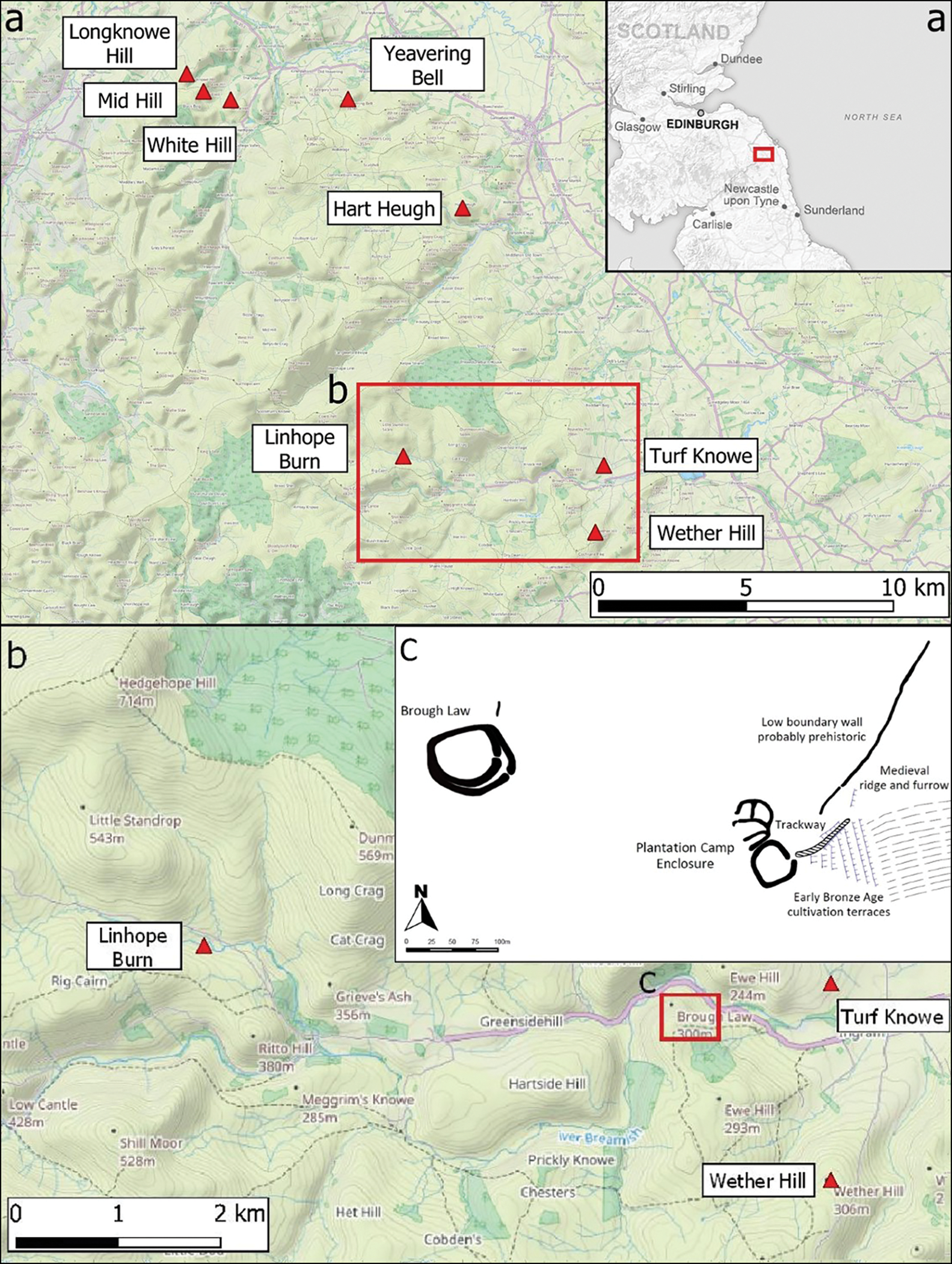
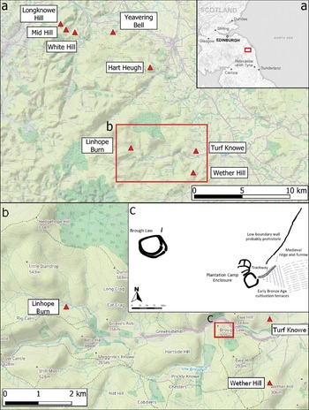
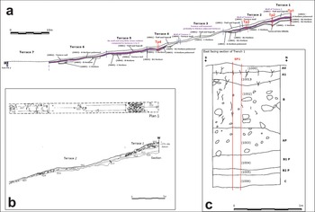
The Ingram Farm Scheduled Monument (National Heritage List no. 1021382) in the Upper Breamish Valley of the Cheviot Hills, Northumberland, UK, is a well-preserved prehistoric to post-medieval archaeological palimpsest, including cairnfields, settlements, hillfort enclosures, orthostats, field systems, ridge and furrow, and agricultural terraces (Frodsham & Waddington Reference Frodsham, Waddington and Frodsham2004; Lotherington & Waddington Reference Lotherington and Waddington2019) (Figure 1). The terraces on the east-facing slope of Plantation Camp Hill (200–218m asl) were first excavated between 1997 and 1999 (Archaeological Services, University of Durham 2000; Frodsham & Waddington Reference Frodsham, Waddington and Frodsham2004) (Figure 1c). The terraces (then thought to be six in number) identified by the original excavation were observed within a small triangular area of approximately 3ha, located above the extensive early medieval ridge and furrow cultivation systems that extend down to the valley floor. Subsequent to that fieldwork, clear-felling of the adjacent conifer plantation in 2021 has revealed that the terraces extend to the south, around Ewe Hill.
a) Location of the Cheviot Hills; b) study site and sites mentioned in the text; c) the terraces, Plantation Camp and Brough Law hillforts (figure by C. Waddington/ARS Ltd).
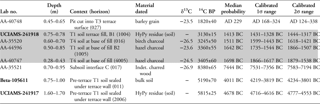
The terraces are overlain by a trackway leading to the entrance of a Roman Iron Age Cheviot-type enclosure and settlement (Plantation Camp; Burgess Reference Burgess, Miket and Burgess1984). The pre-terrace soil underlying the upper terrace revetment has produced Late Mesolithic and Early Neolithic dates (Table 1), providing a terminus ante quem for the terrace construction. Radiocarbon dating of a barley (Hordeum) grain from a pit cut into the top of one of the terrace surfaces (T3) has produced a mid to late Romano-British date (Table 1; Frodsham & Waddington Reference Frodsham, Waddington and Frodsham2004). This secure chronological bracketing between the Neolithic and Romano-British periods motivated our investigation of this particular terrace system.
Calibrated radiocarbon dataset for Plantation Camp terraces. Calibrated age ranges obtained in CALIB 8.2 (Stuiver et al. Reference Stuiver, Reimer and Reimer2022) using the IntCal20 curve (Reimer et al. Reference Reimer2020). The shaded cells cover the period of construction and primary use, as defined by the buried B and Ap horizons. For full probability distributions, see calibration multiplot in Figure S4. Context numbers are in parentheses. Post-2019 dates have their laboratory numbers in bold and δ13C values are provided for standard AMS dates (see OSM4).
Survey, sampling, methods and analyses
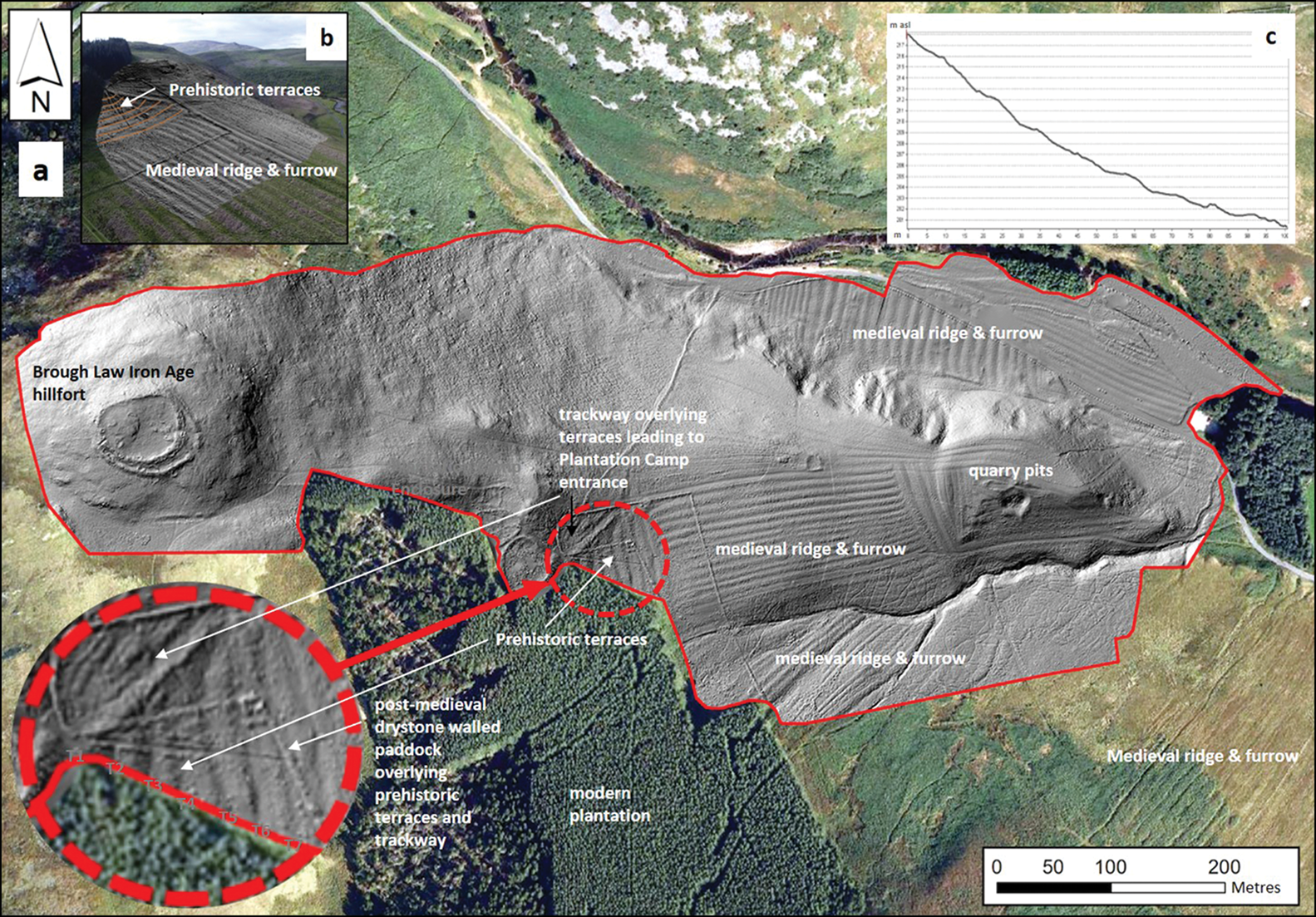
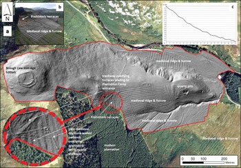
While faint traces of terracing can be observed in open-source LiDAR data (https://environment.data.gov.uk/) (see online supplementary material (OSM) Figure S1), the 2m resolution of the derived digital terrain model (DTM) is inadequate for detailed mapping of the terraces. An autonomous vehicle (UAV) structure-from-motion (SfM) photogrammetric survey was therefore undertaken to generate a high-resolution topographic (HRT) DTM, with a resolution of 0.10m (Cucchiaro et al. Reference Cucchiaro2020) (Figure 2).
a) Shaded relief map of the UAV-SfM DTM with the Plantation Camp terraces on Ewe Hill highlighted (red broken circle), revealing a sequence of seven terraces rather than the previously identified six, together with overlying trackway and post-medieval enclosure walls; b) oblique view of the DTM from the east; c) a relief profile down the terrace staircase generated from the SfM DTM (figure by S. Cucchiaro).
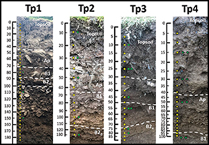
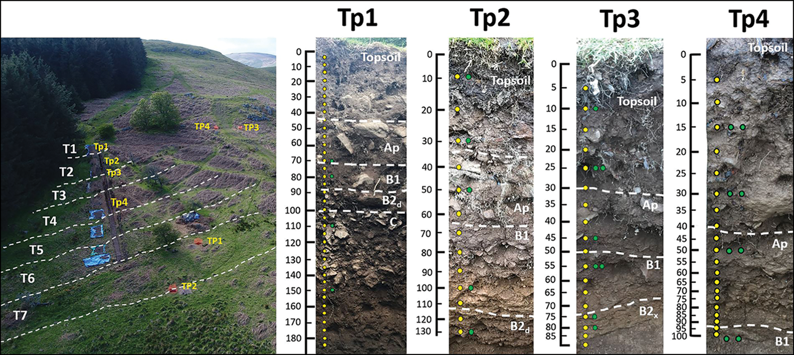
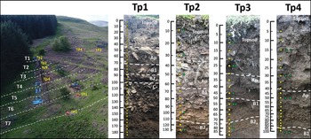
A new 1 × 65m trench was also excavated parallel to the 1999 trench (Figure S2). This trench revealed the stratigraphy of the upper four terraces, and details of the stratigraphy and pedology were recorded and numbered Tp1–Tp4 on terraces T1–T4 (Figure 3; see also OSM1). Samples were taken at regular intervals for portable X-ray fluorescence (pXRF), portable optically stimulated luminescence (pOSL) and phytolith analyses. Luminescence profiling, particularly valuable for the study of terrace and field systems (Sanderson & Murphy Reference Sanderson and Murphy2010; Kinnaird et al. Reference Kinnaird, Bolós, Turner and Turner2017; Turner et al. Reference Turner2021), was used to identify hiatuses in deposition, indicative of excavation and truncation, as well as uniform units typical of tilled soils. Radiocarbon dating was undertaken using standard AMS on charcoal and AMS hydropyrolysis (HyPy). HyPy dates the most resistant organic fraction of the soil (black carbon (BC) or pyrogenic carbon (PyC)) through reductive removal of non-BC components, and so is less susceptible to contamination and intrusion (Ascough et al. Reference Ascough2020). Samples for full OSL age determination were taken, two of which have been processed. Four 1 × 1m test pits were also dug, two of which were placed outside of the terraced area as controls (TP3 and TP4), while the remainder (TP1 and TP2) were dug to investigate a newly identified seventh terrace.
Oblique aerial photo of the trench under excavation, with sampling profiles of each terrace (Tp1–Tp4) and test pit (TP1–TP4) taken to examine the extension of the terraces to the east (TP2) and for control soil profiles. Yellow = pOSL; green = phytolith samples; blue = sedaDNA (figure by C. Waddington/ARS Ltd).
Results and interpretations
The new DTM permits the identification of an additional morphological terrace (T7) below the lowest of the staircase of six previously known terraces (Figure 2); T7 is overlain by the ridge and furrow cultivation extending up from the valley floor. The DTM also shows the trackway leading directly to Plantation Camp, overlying the terraces but underlying the post-medieval field walls. The broad ridge and furrow that overlies the terraces downslope and to the east, as well as both broad and narrow ridge and furrow (plough formed; cf. Upex Reference Upex2004) along the valley side, can also be observed.
The trench stratigraphy reveals some profile variation along the tread of each terrace fill, with discontinuities visible in the pOSL, vanadium, manganese and rubidium/strontium (weathering proxy) profiles, as well as in pH and texture (Figure 4; Table S1). Although not directly related to age, pOSL indicates time gaps or truncation (discontinuity), mixing and/or slow accumulation of terrace soil (cf. Turner et al. Reference Turner2021). The pXRF profiles of various elements can be similarly used to identify formation processes especially, for example, resulting from slow weathering that also increases the rubidium/strontium ratio (Figure 4).
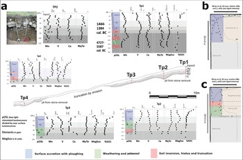
Generalised context stratigraphy of the 2019 trench (a), with insets of the wall of T1 as recorded in the adjacent 1999 trench (b) and the Tp1 profile (c) (figure by D. Fallu).
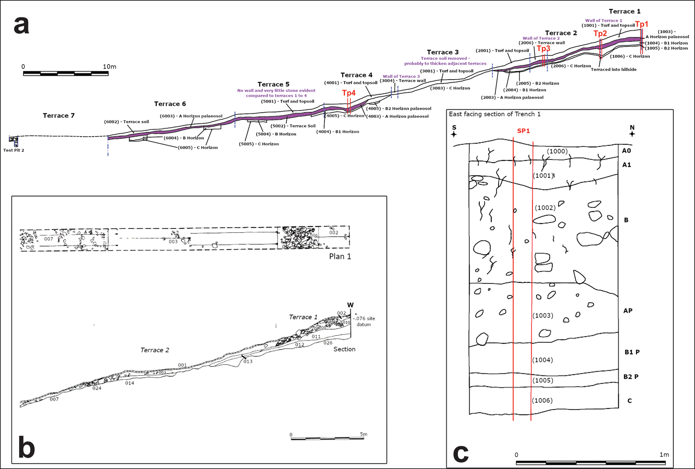
We also dug two control test pits TP3 and TP4 (Figure 3), both of which revealed A horizons of 0.10–0.15m (upper organic horizon) and single B horizons (middle illuvial soil horizons) of 0.30–0.40m of acidic Brown Earths (pH 3.2–4.3) with signs of incipient podzolisation (Figure S3). Only the three upper terraces were associated with collapsed and buried walls (T1–T3, better preserved in the 1999 trench) and appeared to relate to adjacent downslope cuts (Figure 3b). The stratigraphy of the top of the staircase (T1) displays a thickened soil sequence (compared with the control pits) with a basal discontinuity, with the C horizon buried by two B horizons and an Ap horizon that included collapsed blocks from a wall of large, sub-rounded cobbles and boulders of glacial origin.
T2 displays a similar sequence, whereas T3 reveals a thinned, truncated sequence above the lowest wall. Below this wall, T4, resumes the thickened, buried Ap sequence again continuing into T5 and T6, suggesting slope-wash accumulation and burial. T7 was not cut by the new trench and only investigated in TP2, revealing a complex stratigraphy underlying the ridge and furrow and confirming the relationship between the terracing and the ridge and furrow (Figure 2). The vanadium and manganese profiles, alongside the pOSL, show depth profiles with higher values at the deepest levels and the lowest values closer to the surface (with some intermediate peaks (Figure 5)). This is typical of cut-and-fill terraces, which are characterised by leaching producing basal enhancement and a reduction in stoniness due to the preferential downslope movement of finer soil fractions.
Long-section with samples profiles, main stratigraphic contexts, pOSL (in raw counts), manganese (Mn), vanadium (V), calcium (Ca) and rubidium/strontium (Rb/Sr). Black markers show pOSL values falling within bins representing the lithostratigraphic unit containing the Bronze Age dated sample, which are most likely to date to a similar period. Red diamond outlines show the pOSL samples dated with HyPy14C. Colour masks on the profiles indicate likely construction processes in relation to our model (b–c; Brown et al. Reference Brown2021a) and the model proposed by Turner et al. (Reference Turner2021) (figure by D. Fallu).
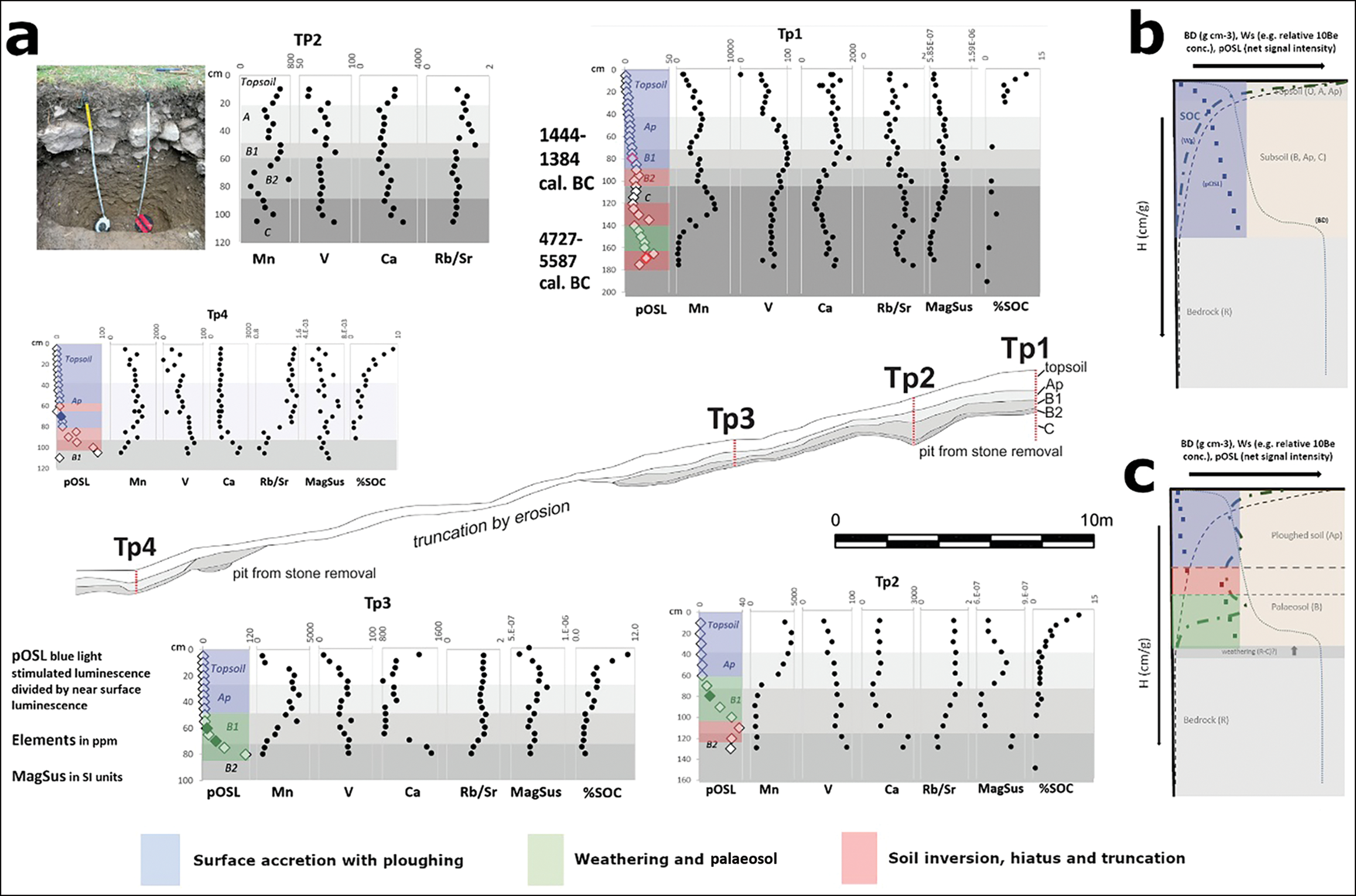
Despite variation between the stratigraphy of each terrace, we can identify both discontinuities and probable units of continuous or ‘slow’ accumulation of soil, deriving from the upper terrace slopes, forming the buried B and Ap horizons (Figure 5). The walls are adjacent to the deepest terrace soil sections, even when there is no significant slope above, suggesting they were built as part of the cut-and fill construction process (Figures 4 & 5). In most of the trench, a clay-rich, and in places stone and clay-rich (approximately 10–15 per cent), indurated basal C horizon (equivalent to fragipan) obscured the underlying andesitic bedrock. The Upper Breamish Valley has smooth slopes underlain by drift (diamictons; i.e. the solifluction sheets of re-sedimented tills), gelifractates and weathered granites derived from reworking of the Kale Water Till Formation—particularly the Linhope Spout Member—which is exposed 4km west at a similar elevation (Harrison Reference Harrison2002). Both the stratigraphy and lithologies (granites and quartzites) suggest that the materials used to construct the walls were dug out of patches of this reworked till.
Samples taken for OSL dating contained insufficient sand-sized quartz to provide dates; however, the combination of AMS radiocarbon dating from previous excavations with new HyPy AMS radiocarbon dates provides a firm chronology for the terraces (Table 1; Figure 5). Two dates from the base of the fill of T1, where the soil from the pre-existing ground surface was spread over the cut-terrace surface and then built over by the overlying terrace edge wall, provide a terminus post quem (terminal Mesolithic to Early Neolithic), after which terrace construction must have occurred. Two dates from the T1 B horizons—one from a charcoal macrofossil, the other on PyC extracted via HyPy—provide an Early Bronze Age (1800–1500 BC) chronology, as do two charcoal samples from the base of the fill of T4. A pit cut into the top of T3 produced a barley grain that provides a terminus post quem of cal AD 124–338 (Figure 3) or latest possible date for terrace construction. This latter date, alongside the superimposition of the trackway to the Plantation Camp enclosure, suggests that construction, but not necessarily use, had ceased by the mid to late Romano-British period. From the overall sequence, construction of the terraces appears to have taken place c. 1890–1520 cal BC (at 95% confidence) and probably 1861–1620 cal BC (at 68% confidence). Use of the terraces continued until the Middle Bronze Age (at least 1444–1317 cal BC). Although a full Bayesian model could not be defined, our best estimate suggests terrace construction and at least initial use took place over approximately 570 years (at 95% confidence) and probably a minimum of 300 years.
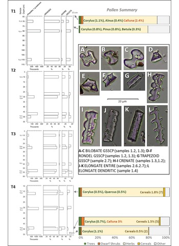
Eight samples were originally taken for pollen and spore analyses, all of which show low concentrations (5400–7092 grains ml−1) typical for soil horizons (Dimbleby Reference Dimbleby1985). Only five were countable to a 250 total land pollen (TLP) sum (Figure 6). All samples were dominated by grasses (Poaceae), sedges (Cyperaceae) and ribwort plantain (Plantago lanceolata), with a low background of trees (1.4–3 per cent TLP) (Figure 6; Table S2). Significantly, all three samples from T4 (Tp4) include cereal-type grains (fully keyed-out as cereal-type (Triticum and/or Hordeum) and distinguished from large Poaceae grains; see OSM5), which vary in proportion from 0.5 to 1.7 per cent TLP. Variation in pollen counts with depth are minor, but there is some indication of degradation and pollen-loss (slight increase in Lactucoideae and Polypodium vulgare). In general, however, the spectra do not appear to be heavily biased by differential preservation, given that the numbers of degraded/unidentifiable grains are low (0–1 per cent TLP) (Table S2). Soil pollen is known to be overwhelmingly locally derived (Sergerström Reference Sergerström1991). Therefore, soil pollen represents the vegetation from the terrace or area immediately adjacent, irrespective of the terrace's formation processes and even if eroded from higher up the terrace staircase.
Summary of phytolith data (grasses, elongate, entire, dicotyledons) and pollen data (trees, dwarf shrubs, herbs, cereals, other) by depth, with an inset of typical types from the samples (A–L). Selected taxa only; for full data, see Table S3 in the online supplementary material (figure by A.G. Brown).

Both the pollen and dated charcoal (Table 1) suggest hazel and birch woodland in close proximity to the terraces, with hazel dominant in the deepest samples from T4. Of 26 samples taken for phytoliths, 20 had sufficient to be countable (concentrations from 1.1 to 21.6 million phytoliths/gram of sediment; Table S3). Principal component analysis (PCA) indicates that the samples fall into three groups and five main morphotypes (Figure 6 & S5). They are dominated by the C3 Pooid grass subfamily, with the presence of sedges in T3. Changes in phytolith abundance and morphological phytolith variation suggest periods of intensive cultivation and changes in cultivars (within the Poaceae family), as well as periods of no cultivation. The dominance of phytoliths from leaves and stems rather than inflorescences suggests the cultivation of cereals, which involves the harvesting of the inflorescent parts for consumption elsewhere. Due to the low number of ‘elongate dendritics’ recovered (Figure 6 & Table S4) we have refrained from a finer taxonomic approach using statistical morphometrics (Ball et al. Reference Ball2016). The identification of ‘rondel tall’ in some of the samples (Table S4), however, suggests the presence of barley, since these morphotypes, which show a circular to oval outer periclinal surface/aspect (OPS) and a greater thickness, are associated with Hordeum (Portillo et al. Reference Portillo, Bofill, Molist, Albert, Anderson, Cheval and Durand2013). Other morphological characteristics of ‘rondels’ with a circular to oval OPS and an inner periclinal surface/aspect (IPS) variable in shape (ICPN 2.0; International Committee for Phytolith Taxonomy 2019) are also consistent with the presence of barley.
Discussion
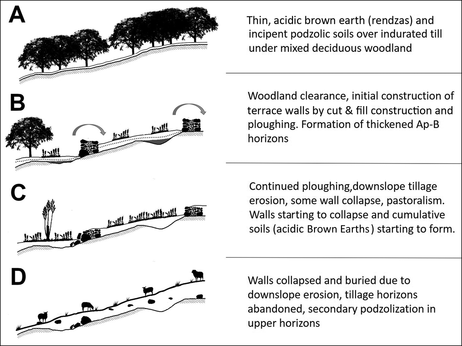
Based on our results, we can propose the following model for terrace formation. The terraces were constructed in a landscape largely cleared of trees but with some, possibly managed, hazel and birch. The terraces appear to have been constructed using a combination of methods, including: building a wall directly on the hillside and infilling the area upslope (e.g. T1); cutting into the hillside, inserting a wall and covering the tread created with soil (e.g. T3); and adapting naturally occurring shelves (e.g. T7). The walls, of locally sourced stone, were constructed with substantial front and rear faces or revetments, especially T1 to T4; the space between the revetments was filled with smaller stones. Soil removed during construction was placed back on to the terraces to fill the areas behind the terrace walls (see Figure 7). Cultivation then proceeded on the treads. Over time, stones cleared from the terrace soils were piled along the inner edge of the wall, serving the dual purpose of clearing stone and augmenting the terrace wall. This retained the increasing depth of soil formed by tillage-erosion and the addition of colluvial material, which is reflected in the slow accumulation of soil as indicated by the upper profile pOSL trends. These deeper soils offered significant benefits for farming, including enhanced water retention, higher nutrient content, greater rooting depth and the creation of a loose tractable tilth.
A schematised history of the Ingram terraces, based on T1–T4 and the model by Waddington (in Frodsham & Waddington Reference Frodsham, Waddington and Frodsham2004): A) Neolithic; B) Early to Middle Bronze Age; C) Iron Age to Romano-British; D) medieval to post-medieval (figure by A.G. Brown).
The dating of the construction of this hybrid cut-and-fill terrace staircase to the Early Bronze Age (defined as c. 1800–1500 cal BC) is consistent with the concept of an ‘agricultural revolution’ (see Childe Reference Childe1936, though referring there to the Neolithic), and as illustrated by the analysis of cereal dates from Bronze Age Britain (Stevens & Fuller Reference Stevens and Fuller2012), which demonstrates a strong upturn c. 1500 cal BC. The synchronous appearance of unenclosed roundhouse settlements with associated field and terrace systems at this time presents a sudden change, with no prior evidence for such density and permanence of settlement across this landscape. Whether this implies a considerable increase in population continues to be debated, as without excavation and dating the contemporaneity of sites remains contested. The sheer number of unenclosed settlements visible as surface remains (with several hundred across the Cheviot Hills), however, suggests a period of dense settlement, and many must have been contemporaneous based on numbers alone. Moreover, the available archaeological evidence indicates that most investigated settlements are multi-phase, as at Green Knowe (Jobey Reference Jobey1979), Houseledge West (Burgess Reference Burgess, Spratt and Burgess1985) and Hallshill (Gates Reference Gates2009).
In the Cheviot Hills, farms and settlement reached their highest elevations during the Bronze Age, at more than 350m asl and sometimes as high as 420m asl (Jobey Reference Jobey, Spratt and Burgess.1985; Gates Reference Gates, Chapman and Mytum1983). Iron Age hillforts and palisaded sites, sometimes with associated patches of cord rig (spade-dug) agriculture, rarely, if ever, attain these heights, but rather cluster at 200–350m asl within our study area, whilst medieval rig/ridge and furrow rarely extends above 300m asl (Topping & Pearson Reference Topping and Pearson2008). Indeed, the reason these high-altitude Bronze Age settlements, field systems and terraces survive across the Cheviot Hills is precisely because no subsequent arable farming has taken place at such high elevations. Based on a GIS analysis of the south-east Cheviots, which encompasses our study area, Topping and Pearson (Reference Topping and Pearson2008: 61–62, fig. 35) concluded that “unenclosed settlements extend to a much higher altitude than any of the other settlement types within the South East Cheviot Project area”. This observation may be explained by population pressure and land-hunger along the eastern flank of the Cheviots, or by favourable climatic factors which allowed settlement to succeed at higher altitudes.
Tipping (Reference Tipping2010: 174–76) and Waddington and Passmore (Reference Waddington, Passmore, Crellin, Fowler and Tipping2016) have contested Burgess’ (Reference Burgess, Miket and Burgess1984) view of the abandonment of valley floors in favour of upland colonisation during the second millennium BC. More recent excavation of Bronze Age unenclosed settlements in valley floor locations across the Milfield Plain (Waddington & Passmore Reference Waddington, Passmore, Crellin, Fowler and Tipping2016), as well as those discovered via aerial photography, such as Low House West (Gates & Deegan Reference Gates, Deegan, Passmore and Waddington2009: fig. 4.11), have confirmed that the upland expansion of Early Bronze Age farming was not associated with lowland abandonment. The onset of formalised and more intensive farming in the Cheviot uplands from the early second millennium BC onwards should thus be considered as a process of expansion, rather than displacement. It is unlikely that this could have happened without an increase in population, particularly given the labour-intensive nature of cultivation at this time. Enhanced Bronze Age river-channel and floodplain adjustment in certain reaches of the River Breamish/Till are also likely linked to catchment disturbance caused, for example, by clearance and cultivation on upstream slopes (Passmore & Waddington Reference Passmore and Waddington2012).
The pollen and phytolith analyses indicate that the terraces were constructed in an open, almost tree-less environment and were used for cereal cultivation in the Early Bronze Age, and possibly into the Iron Age/Romano-British periods. This is supported by the discovery of a broken andesite quernstone for milling cereals, which had been repurposed in the T4 wall found in 1998 (Archaeological Services, University of Durham 1998), as well as the discovery of barley grains used in the temper of an Early Bronze Age food vessel from the Wether Hill burial pit just south of the terraces (Topping Reference Topping and Frodsham2004: 194). The large numbers of funerary monuments and cairnfields—many yielding Bronze Age burials, including those at Turf Knowe and North Knoll (Frodsham & Waddington Reference Frodsham, Waddington and Frodsham2004) just 1km to the south-east of the terraces—provide further evidence of a sizable Bronze Age population. Together, the archaeological data lend support to the view of widespread Bronze Age settlement, field systems and associated burial sites across the eastern Cheviot uplands, supporting higher population levels than before. Work to the west, in the adjacent Bowmont Valley, however, suggests that small farmsteads also persisted throughout the Bronze and Early Iron Ages within permanent, but relatively small-scale woodland clearances, with abrupt and comprehensive woodland clearance occurring in the Late Iron Age (Tipping Reference Tipping1998, Reference Tipping2010). This apparently lower density of Bronze Age settlement and farming in the western Cheviots may reflect a less favourable aspect for farming (Tipping Reference Tipping2010; Tipping et al. Reference Tipping2012), in contrast with the more attractive eastern Cheviots with their clear pattern of south-east facing cultivation terraces (Topping & Pearson Reference Topping and Pearson2008).
The archaeological landscape surrounding the Plantation Camp terraces demonstrates that they were constructed in an intensively used area, with roundhouses, fields, cultivation plots, clearance cairns, agricultural terraces and funerary monuments. The Breamish Valley Archaeology Project has investigated many of these sites and produced a wealth of data about them (Frodsham & Waddington Reference Frodsham, Waddington and Frodsham2004). Of relevance here is the identification of a Bronze Age cremation burial at Turf Knowe North of a child who had meningitis (cremation 1; Fowler Reference Fowler2013); this was probably meningococcus, a disease that is endemic in areas with high population densities (Howitz et al. Reference Howitz2009).
The earliest settlement forms in this landscape are Early Bronze Age stone roundhouses, which are usually associated with adjacent field systems and cairnfields. Unenclosed settlements range in size from individual huts to groups of between two and four houses measuring between 5m and 10.5m in diameter. Many were set into the natural hillslope with a visible back scarp of up to 0.8m high, while several others were constructed on terraces. Other unenclosed settlements were of timber construction and are visible on the surface as shallow circular grooves, marking the slots into which the wall timbers were set; other timber structures have left no surface traces and can only be identified as rings of postholes following the soil stripping, such as on Wether Hill (Topping Reference Topping and Frodsham2004).
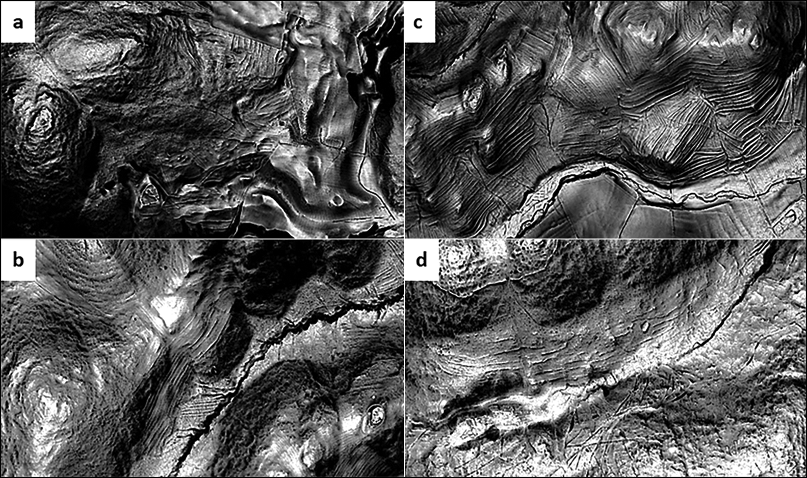
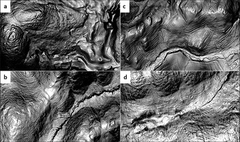
The terraces at Plantation Camp are by no means unique. Other examples are known across the Cheviots, such as those mapped as part of the Northern Cheviot Hills Aerial Investigation and Mapping Project (Goodchild Reference Goodchild2021). At Hart Heugh (Figure 1), the close association of the terraced field system with unenclosed hut circles and cairns suggests that it has Bronze Age origins, despite it appearing to have undergone Iron Age reuse and remodelling (Figure 8). This can be contrasted with an extensive system of cultivation terraces on the south-east facing slopes of White Hill, as well as Mid Hill and around Yeavering Bell (Figure 8), where the terraces are substantial bank features up to 7m wide. The excavation of an agricultural terrace at Linhope Burn produced an early medieval radiocarbon date, suggesting that some of the terrace systems on the lower slopes could date to, or have been reused in, the early medieval period (Frodsham & Waddington Reference Frodsham, Waddington and Frodsham2004).
Other similar terrace systems in the region: a) Hart Heugh; b) Mid Hill (with settlement ringed); c) White Hill; d) Yeavering Bell (figure by C. Waddington/ARS Ltd).
There is evidence for climatic/hydrological change in the Bronze Age, with proxy-records showing cooler and/or wetter conditions c. 1600 BC (Brown Reference Brown2008) and flooding c. 1540 BC (Macklin et al. Reference Macklin, Johnstone and Lewin2005). There is also evidence of a shift to a cooler and/or wetter climate c. 1395–1155 BC, coinciding with the abandonment of the Dartmoor Reaves system (Amesbury et al. Reference Amesbury2008). Burgess (Reference Burgess1989) linked later Bronze Age abandonment of the Cheviot Hills with the impact of the Hekla 3 eruption (950 BC), whilst others have pointed to the impact of soil erosion/exhaustion and changing social organisation as other possibilities (Young & Simmonds Reference Young and Simmonds1995; Waddington & Passmore Reference Waddington, Passmore, Crellin, Fowler and Tipping2016). The dates for the Dartmoor Reaves and Plantation Camp terrace construction are similar, although the Reaves are at a higher altitude (380–420m asl) and 5° further south. Even though we cannot suggest that climate influenced the construction of the terraces, it is a possible reason for their abandonment, which may have lasted at least until the Late Iron Age/Romano-British period.
Conclusions
Hybrid cut-and-fill-type terraces were constructed in the Early to Middle Bronze Age in the Breamish Valley, Northumberland. The evidence suggests that the terraces were used for cereal cultivation for at least some of their use-life. This agricultural intensification, within what appears to have been an already largely cleared landscape, was part of the creation of a densely settled and farmed Bronze Age landscape, including domestic and ceremonial/funerary elements. Since flatter land exists over most of the surrounding landscape, the creation of these terraces suggests either that this location was significant enough to warrant the investment of time and labour, or that dense population levels necessitated exploitation of all available land. Either way, this can be seen in the context of wider European Bronze Age agricultural intensification (Kvapil Reference Kvapil, Hollander and Hoowe2020), although the relative roles of population pressure, changing social organisation, and immigration and cultural influences from the Continent remain to be investigated. This study not only reveals that agricultural terrace construction and use corresponded with the onset of roundhouse construction and settled agriculture, but also that the unravelling of these multi-layered landscapes is now tractable due to advances in high-resolution survey, sediment dating and profiling, and palaeoecological techniques.
Funding statement
This work was funded by the H2020 European Research Council (ERC Advanced Grant No. 787790 TerrACE, PI A.G. Brown).
Supplementary material
To view supplementary material for this article, please visit https://doi.org.10.15184/aqy.2023.1.


 Open access