


The Roman reconquest of Antioch in 969 created new borders in Syria, defined first in the so-called Treaty of Safar with Hamdanid Aleppo and shortly thereafter with the Fatimid Empire. These borders demarcated territory and were visibly marked on the landscape, at least between Roman territory and its client in Aleppo.Footnote 1 Roman control is attested as far up the Orontes as Shayzar up to the late eleventh century; the empire also held the coast south to Antarados and, inland, the Oionoparas valley.Footnote 2 Between the Orontes valley and the coast lies the Jabal Bahrāʿ, the Syrian Coastal Mountains. Lacking any substantial urban foundations, this small upland strip was virtually ignored by contemporary writers. An exception to this occurred during a brief moment following the failed expedition of Romanos III (r. 1028–34) against Aleppo in 1030. The Christian physician Yaḥyā ibn Saʿīd al-Anṭākī, who had previously fled the persecutions of the caliph al-Hakim (r. 996–1021), provides a detailed account in his Arabic History of a short, localized conflict in the Jabal Bahrāʿ that threatened to spiral into a regional crisis involving Aleppo, Tripoli, and the Fatimid Empire.Footnote 3
This small war provides a neglected but important testimony to client management on the imperial fringes and a shadowy glimpse of the people who lived in the ungoverned zones between empires. Despite the Roman Empire’s absence from Syria for some three centuries, much activity in this conflict has parallels with the better-studied Roman–Sasanian frontier, suggesting that fundamental models of Roman imperial frontier management echoed down the centuries. Here, GIS (Geographic Information Systems) will supplement more traditional text-based historical approaches. The conflict zone will be examined through cost-corridor analysis, a relatively new technique that looks at the difficulty of human movement in passing through a given zone. This permits us to consider the Jabal Bahrāʿ and its immediate surroundings as varying shades of imperial landscapes. Events brought the two empires directly into the mountains, but their activities were influenced by the relative accessibility each had to the conflict zone, which can be measured through least-cost corridor analysis.
The Roman Empire’s still-extensive frontiers after the Bulgar and Arab conquests of the seventh century have received nothing like the attention lavished upon those of earlier times. In 1996 Hugh Elton could publish a general interpretation covering ‘imperial’ Rome’s vast reach in a short book, but even thirty years later such an equivalent set after the sixth century would seem premature.Footnote 4 The study of Roman frontiers has not always kept pace with developments elsewhere and has failed to understand the indigenous peoples on these frontiers as parts of broader Roman power networks.Footnote 5 Excellent work has been done on individuals and ideas that crossed frontiers, but the frontiers themselves and the borders that demarcated what Constantinople controlled from the rest of the world rarely receive much attention. Even in cases where the borders appear porous we still need to ask why that was so.Footnote 6 Some pushback has appeared, but the basic situation is that studies of East Rome’s frontiers, frontier policies, and border controls are few and far between.Footnote 7 Some regional studies have appeared recently, but much more is needed.Footnote 8 Despite a significant part of the eleventh-century crisis stemming from the empire’s inability to defend its frontiers, it is notable that in a number of recent edited volumes on the topic, not a single paper discusses frontier management.Footnote 9 Moreover, while the study of Roman fortifications along the frontiers has virtually become a subfield, the study of fortifications after the seventh century is still in its infancy.Footnote 10 Fortifications always exist within both social systems and broader defensive schemes, and those had to be designed, built, and paid for, and are thus reflective of the priorities of those who invested in them.Footnote 11 The following examines a brief moment in the history of the Roman border with the Fatimid Empire in Syria to shed light on long-term continuities and discontinuities in imperial frontier management.
Context and geography
The year 969 ushered in a new political order to the eastern Mediterranean. In the north, the Roman reconquest of Antioch played out as part of their ongoing struggle against the Hamdanids of Aleppo (Beroia), whose energetic rulers, operating with a free hand as the Abbasid Caliphate disintegrated, pushed back against the empire’s expansion eastwards.Footnote 12 In the south, the Fatimids, an Ismaili dynasty based in what is now Tunisia, seized Egypt. Four years later the Fatimids moved into their new capital of Cairo, but their intention was always to continue east and establish themselves in Baghdad. The two empires would collide over control of Aleppo. Aleppo was the north Syrian crossroads where routes to Anatolia, the Caucasus, Iraq and the Persian Gulf, and Egypt and the Red Sea converged.Footnote 13 Initial attempts to seize Aleppo outright were unsuccessful, and the Romans had to content themselves with a client state. For the Fatimids, Aleppo could not be bypassed on the road to Baghdad, and in anyone’s hands but theirs the city threatened overland communications with their Mediterranean empire.Footnote 14 These conflicting interests resulted in aggressive campaigning during the last decades of the tenth century, although the establishment of a modus vivendi during the eleventh meant that from then on the conflict simmered rather than boiled (Fig. 1).Footnote 15
Northwestern Syria with places mentioned in the text. Author.

Fig. 1 Long description
The map depicts northwestern Syria, highlighting cities and geographical features. Key locations include Antioch, Aleppo, Tripoli, and Homs. Other labeled places are Artach, Kurin, Innab, Apameia, Shayzar, and Hama. Coastal cities like Laodikeia, Balatunus, and Antaradus are marked. Inland areas feature places such as Qusair, Hisn al-Khawabi, and Masysas. The map includes roads and rivers, with a compass rose indicating north. Hillshade provides the appearance of changes in elevation.
Nikephoros II Phokas (r. 963–69), John I Tzimiskes (r. 969–76), Basil II (r. 976–1025), and Romanos III Argyros all led major campaigns into Syria over more than half a century. With the exception of Romanos, who targeted Aleppo, these emperors followed a broadly similar route by heading south between the Orontes and Quwayq before returning northwards along the Mediterranean coast.Footnote 16 No source suggests that any military detachments entered the Jabal Bahrāʿ. The closest any of the campaigns came is a brief mention that Basil seized Ḥiṣn Abī Qubays on the 999 campaign, which is on the very edge of the mountain range.Footnote 17 The Jabal Bahrāʿ barely makes an appearance in al-Anṭākī’s History before the 1030s, and once he finished describing the events there, little is known about the sites in question before the arrival of the crusaders. However, al-Anṭākī provides a valuable snapshot of local frontier management in a small geographic space during a short time span. The events have been described in detail by Wolfgang Felix and Thierry Bianquis, although both follow al-Anṭākī’s account closely.Footnote 18 Nonetheless, what happened in the Jabal Bahrāʿ is insightful for what it reveals about how frontier military governors balanced relations between local actors and nearby great powers, client relationships, and how the empire attempted to manage its border territories.
Al-Anṭākī’s narrative of the events in the Jabal Bahrāʿ is a coherent unit, set right after the defeat of Romanos III at Aleppo.Footnote 19 Al-Anṭākī begins by introducing his readers to Naṣr ibn Musharraf al-Rawadifi as the leader of the local Muslims. Musharraf had been imprisoned twice in Antioch and was released the second time at some point in the latter half of the 1020s.Footnote 20 Musharraf reportedly convinced the katepano Michael Spondyles to build a fortress at Menikos before ‘the Muslims’ did, as failure to do so would harm Roman control over the region. Musharraf promised to construct it himself on behalf of the empire, and Spondyles gave him written permission to do so.Footnote 21 Construction only began after 1029, at which point al-Anṭākī mentions that Musharraf requested additional assistance in terms of men and material.Footnote 22 Al-Anṭākī’s account suggests that Musharraf’s deception began around this time, and the new doux or katepano (Constantine Karantenos, but unnamed by al-Anṭākī) seems to have had his suspicions at first, since he dispatched men to Gabala to check up on Musharraf’s activities following reports of Muslims gathering at Menikos.Footnote 23 Musharraf’s deception worked; he received support in the fortress’ construction, but then refused to hand it over.Footnote 24 Musharraf decided to build another fortress, this one at Bikisrāʾīl, but the katepano took no chances this time and drove off Musharraf’s men and constructed the fortress there and garrisoned it.Footnote 25 The fortress soon fell to Musharraf, having run out of water during a blockade, which seems to have been around the time of the failure of Romanos’ Syrian expedition in summer 1030.Footnote 26 Musharraf seems to have been emboldened by the debacle outside of Aleppo, and Romanos’ dismissal of Karantenos and his replacement by Niketas of Mistheia initially resulted in a power vacuum that gave the local actors in the Jabal Bahrāʿ the opportunity to strengthen their hand.Footnote 27 The Banū al-Ahmar constructed a fortress at Balāṭunus, and the Banū Jannāj built two. As al-Anṭākī noted, this made Roman control in the north of the Jabal Bahrāʿ precarious.Footnote 28 Balāṭunus was not far from two of the roads between Antioch and the key port of Laodikeia.
Musharraf received support from Tripoli and besieged Marakeus, which Niketas immediately moved to relieve upon his arrival in Antioch. After driving them off, Niketas made a punitive raid in the vicinity of Tripoli, seizing animals from Arka.Footnote 29 How Niketas returned to Antioch is unclear; al-Anṭākī mentions he deviated from his path and also made a raid against Kurin (Kaprokoraon), near Aleppo.Footnote 30 This suggests that Roman troops made a complete march around the Jabal Bahrāʿ, in the opposite direction that the imperial campaigns over the previous half-century had gone. Reinforcements then arrived under the command of the protovestiarios Symeon, which, together with Niketas, attacked Azazion and forced Aleppo under Naṣr ibn Ṣāliḥ back into the Roman orbit. Al-Anṭākī reports that the campaign took place at the end of 1030 and the client agreement was arranged in April–May 1031.Footnote 31
Aleppo dealt with, Niketas turned back to the Jabal Bahrāʿ. He approached with carrot and stick: when his offer of gifts was refused, he besieged Balāṭunus. The fortress soon surrendered, as did the two unnamed fortresses (‘fortress of the Banū Jannāj’ and ‘fortress of Ibn al-Kasih’), both of which the katepano then had dismantled. Niketas then assaulted Menikos, but lacking the equipment to take it, he again raided Arka before returning to Antioch.Footnote 32 At this point the only other historical account with any detail offers a slight variation. Ioannes Skylitzes, writing in Constantinople a century later, says that Niketas’ failure to take Menikos inspired Romanos to send the megas hetaireiarches and protospatharios Theoktistos to Syria.Footnote 33 This was allegedly done in support of ‘Pinzarach’, the renegade emir of Tripoli, who has been identified as Ḥassān ibn al-Muffarij ibn al-Jarrāḥ. In the late 970s, the Fatimid solution to controlling Palestine had been to rule through Ḥassān ibn Jarrāḥ, the grandfather of ‘Pinzarach’. However, his Bedouin caused extensive devastation, and he was expelled in the early 980s; it was only following a major Bedouin revolt in 1024 and the arrival in 1029 of the Turkic Fatimid governor Anūshtakīn al-Dizbirī in Damascus that Cairo asserted more direct control over the region.Footnote 34 The Fatimids had managed to bring Ḥassān ibn al-Muffarij under their control, but following a dispute over lands around Jerusalem, he fled to the Roman Empire.Footnote 35
Curiously, al-Anṭākī makes no mention of additional Roman forces dispatched to the region, even though Skylitzes claims it was the forces of the megas hetaireiarches that took Menikos and Argyrokastron. In any case, the reinforcements may not have been numerous: in the mid-eleventh century, Ibn Buṭlān reports that Antioch had some 4000 soldiers.Footnote 36 Assuming these numbers had not changed drastically, most were probably involved with garrison duty and not available for campaigning, since when Constantine Dalassenos attacked Aleppo in 1025, he dispatched only 300 men.Footnote 37 Skylitzes further misrepresents matters in claiming that Ḥassān ibn al-Muffarij was the rebellious emir of Tripoli. Tripoli was ruled by a semi-independent qāḍī loyal to the Fatimids.Footnote 38 However, Ḥassān ibn al-Muffarij and the Jarrāḥids lived not far from Tripoli, and as Yaacov Lev has noted, Tripoli was as contested between the Romans and the Fatimids as Aleppo: it was attacked repeatedly by Rome, although the empire was consistently unsuccessful in taking the city or installing a client. Keeping Ḥassān ibn al-Muffarij in Constantinople as the ‘emir of Tripoli’ was a diplomatic move. Constantinople was well-informed about the trouble that Ḥassān ibn al-Muffarij and the Jarrāḥids had caused for the Fatimid governor in Damascus. In al-Anṭākī’s draft of the truce negotiations, the status of Ḥassān ibn al-Muffarij is one of the issues under discussion, and one contentious enough that the caliph al-Zahir (r. 1021–36) refused the Roman proposal.Footnote 39 Keeping princes-in-waiting, however dubious their claims, was a time-honoured practice of Roman statecraft and diplomacy, both as a means of insurance and for the creation of pro-Roman elites.Footnote 40
Niketas’ next campaign against Menikos started in Raphaneia, which was supplying the fortresses of the Jabal Bahrāʿ with food. The katepano drove out the inhabitants and razed the locale’s towers to the ground before attacking Safita. Al-Anṭākī mentions only that it was besieged and that Niketas managed to free an important prisoner.Footnote 41 Niketas then finally attacked Menikos. Filling the ditch with trees and rocks, his troops were able to breach the walls on 1 December 1031 and a large number of prisoners were taken, including close family members of Musharraf.Footnote 42 Menikos was rebuilt, provisioned, and garrisoned. Niketas returned to Antioch but stopped on the way at Bikisrāʾīl in the hope of convincing its garrison to surrender in exchange for some of the prisoners, but was turned away. On the way back Niketas also stopped at the yet-unidentified village of Jarīrīn, presumably somewhere in the vicinity of Apameia, and seized yet more prisoners since its inhabitants were raiding Roman territory.Footnote 43 Niketas’ return route was evidently down the Orontes valley, although al-Anṭākī mentions that he made the Jarīrīn detour with elite troops, indicating that much of the army was elsewhere. However, Niketas did not plan to solve the Apameia–Jarīrīn issue himself, and he ordered Naṣr ibn Ṣāliḥ, the lord of Aleppo newly in the Roman orbit, to annex and secure it. Niketas’ next action was in response to some Druze who had settled in the Jabal al-Summāq and who were oppressing Muslims and threatening both Roman and Aleppine territory. Troops were dispatched and they were driven out in March–April 1032.Footnote 44
The situation then became significantly more complicated. Musharraf, witnessing his control over the Jabal Bahrāʿ crumble, turned to al-Dizbirī in Damascus. Both Niketas and al-Dizbirī were laying the ground for a lasting truce between the two empires, and Bikisrāʾīl became a sticking point. Al-Dizbirī wished to support Musharraf; the Fatimid general even crossed into Roman territory and scattered the camps of the Jarrāḥids near Innab (ʿInāb) and Qasṭūn. Al-Dizbirī had hoped to use the Banū Kilab in support of Musharraf, but they had already been drawn off by Naṣr ibn Ṣāliḥ.Footnote 45 Failing in this, the Fatimid general retreated from Apameia after one day, writing to Niketas in an attempt to explain why he had crossed into Roman territory and releasing some Armenians his army had taken prisoner as a sign of good faith.Footnote 46
Least-cost corridors
To examine how geography shaped the conflict, the first GIS technique employed here is the least-cost corridor. The fundamental assumption underlying least-cost movement models is that, while travelling, humans and animals seek to expend the least energy possible. The least-cost corridor is a relatively new tool in ArcGIS Pro, introduced in version 3.2 in November 2023, although the concept of cost corridors is much older.Footnote 47 The least-cost corridor is intended to provide a solution to some of the problems with least-cost paths, a technique widely used in archaeology as a simple means of investigating connectivity.Footnote 48 Least-cost paths are a computational technique that calculates the most efficient route through a landscape, which can include factors such as physical geography, hydrology, visibility, and social costs.Footnote 49 The technique is as widely used as it is criticized for having deterministic start and end points, for assuming modern concepts of efficiency, and for the uncritical application of modern geo-data to the distant past. One solution is to ask questions that the models are better suited to answer. For instance, movement in a military context is often about arriving at a particular spot quickly or by an unobserved route, something that such modelling is equipped to answer.Footnote 50 Getting from one place to another thus suits the study here, but where the corridor improves on the path is that it does not provide a single result. The least-cost path algorithm draws a single line through the landscape; from this, the user does not know whether a radically different result might only have ‘cost’ a tiny bit more. The corridor essentially shows the entire landscape through the least-cost path technique, but visualized into zones of low or high cost from the two chosen points. Readers should be aware that this is a new, yet-to-be-theorized technique and that its use here is experimental.
The first step towards creating a least-cost corridor is building a cost surface. A cost surface is a two-dimensional grid divided into cells of an equal size that are each assigned a value. The least-cost path technique seeks to find the most efficient route through the grid, namely the path with the lowest total sum (the ‘cost’). The challenge for both the geographer and the historian is to come up with the figure assigned to each cell and justify it. Every cell in the grid of the cost surface was set at 30m2. The first piece of data was a simple polygon in the shape of the Mediterranean; salt water was assigned a slope value of 99, along with the now-drained Lake Amuq to the north-east of Antioch. Giving open water this number serves to make it impassible. Slope is the rate of change of elevation; good mathematical work exists on human energy expenditure at different grades.Footnote 51 Slope has an enormous impact on the speed and efficacy of human travel and so serves here as a common reference point. Physical geography as slope was also the next set of data integrated into the cost surface. This is derived from a global digital elevation model (DEM) created by NASA.Footnote 52 In this dataset, each cell is assigned an elevation value. Elevation, however, tells us nothing about how difficult it is to cross each cell; what is needed here is the rate of change of elevation. This was attained by running the DEM through ArcGIS’s slope tool, which measures groups of cells to determine slope. Each cell of the result is assigned an output in degrees. As every single land cell in the study area has a value, slope forms a substantial portion of the cost surface.
The next step was to add values for inland water.Footnote 53 Inland water is important to least-cost models because, trite as it might sound, water flows downhill. Millennia of active hydrology have literally shaped the landscape by creating paths of least resistance. Unless otherwise informed, however, the least-cost algorithm does not read these channels as water; rather, it tends to see them as the gentlest slopes in any given landscape and thus has a predilection towards traversing water courses. Since humans cannot walk on most of these courses in the eastern Mediterranean in the way they could, for example, on Baffin Island in February, a number needs to be supplied to give the streams a cost. Based on previous work set in another part of the world, streams were assigned an arbitrary 15 degrees of slope. This has been shown to accomplish two things: first, to prevent the algorithm from crossing the same stream multiple times just to ‘walk’ in lower-cost cells, and second, not to force the algorithm to go on circuitous routes to avoid crossing the streams altogether.Footnote 54 This is plausible enough for the small streams of the eastern Mediterranean. The dataset employed comes in both ‘variable’ and ‘constant’ versions, the former being higher flow volumes at wetter points of the year and the latter being the minimum flows. The ‘variable’ data were used here, although most of these streams are quite small and the practical differences between these two datasets in this part of the world are minimal.
The final set of data used here is ground cover.Footnote 55 Ground cover necessitates the use of fairly coarse satellite data that reflects current land-use patterns, but nonetheless can be cautiously applied to earlier periods. The Mediterranean has not undergone any major changes in vegetation regime during the Holocene.Footnote 56 The dataset presents different types of ground cover by assigning them an arbitrary value.Footnote 57 This was converted into degrees slope using the reclassify tool. This is a process laden with value judgement and personal experience in walking about the region. Mosaic vegetation, rainfed cropland, and deciduous trees were assigned a value of three degrees of slope, evergreen and shrubland assigned a value of five degrees of slope, and areas of dense vegetation (‘closed’) assigned seven degrees. Urban and bare areas were assigned a value of three degrees, under the reasoning that the former were more likely to be cropland or mosaic vegetation in the eleventh century, and the latter are relatively easy to move through and any inhibiting factors there will come from the slope. Although road data for Syria are available from the Tabula Imperii Byzantini, too little is known about secondary roads and local tracks. Factoring roads into movement models has a significant impact on the results.Footnote 58 Adding road data would privilege movement outside the Jabal Bahrāʿ since comparable data is not available for the interior. All of this data was summed using the con function and projected to UTM Zone 37N. Once the cost surface was created, the creation of distance accumulation rasters was carried out, which is required to run the least-cost corridor tool.Footnote 59
The second GIS process carried out here is the viewshed, done with the geodesic viewshed tool and on the same DEM and projection. The viewshed is a simple technique – it determines a line of sight between the observer point and every other point in the landscape. Viewsheds are especially useful in the study of fortifications, since seeing from them (or not) is a useful indicator of their function.Footnote 60 The viewsheds taken here should be considered preliminary; a more complete study should take into account the visibility of the fortress itself from the surrounding territory, as well as fuzzy viewsheds to account for degradation of visibility at distance and in specific weather.Footnote 61 Moreover, on-site investigation would be an advantage in any study of a fortress’ visibility, but the current political situation in Syria makes that challenging. Nonetheless, the viewsheds were conducted with two specific questions in mind: (1) How far up and down each valley can an observer in the fortress see? (2) Are the fortresses inter-visible? The viewsheds were taken from an observer height of 20m. Surviving ruins at the sites are largely twelfth-century or later, and so this height is based on two surviving contemporary early eleventh-century towers from the other side of the empire. These are located in Biccari and Casteluccio Valmaggiore, Italy, and rise to a height of 23m and 20m, respectively.Footnote 62
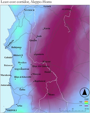
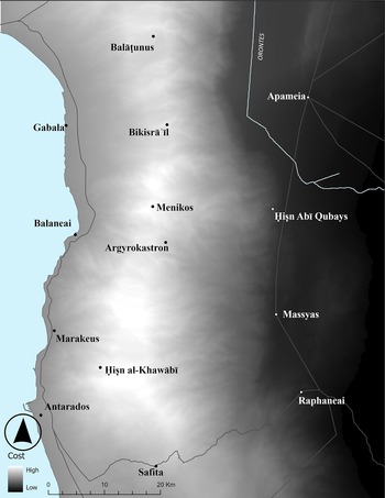
Visually, the corridors present the landscape between the Aleppo–Homs and Antioch–Tripoli points in a shade that represents approximate difficulty. Since the Jabal Bahrāʿ does not directly lie between any of the sets of points, any route through it would have a longer distance, and thus a higher cost. The lighter the colour, the higher the cost, and although this is not a terrain map, the Jabal Bahrāʿ is visually distinct. The least-cost corridors provide a sense of access to the Jabal Bahrāʿ. The inland corridor, built from the distance accumulation rasters that connect Homs and Aleppo, does not directly pass through the mountains (Fig. 2). This was by design; this mountainous region was peripheral until the 1030s. By not being in a direct line between the origin points, the added distance increases the ‘cost’ slightly. In the visual representation shown here, the fortresses are in the hardest access zone for the Aleppo–Homs corridor (Fig. 3). In effect, getting to Antioch is easier than getting to the Jabal Bahrāʿ fortresses. Moreover, a trip between Aleppo and Homs that went on the coast around the Jabal Bahrāʿ is still easier than accessing sites in the interior.
Least-cost corridor, Aleppo–Homs. Author.

Fig. 2 Long description
The map illustrates the least-cost corridor between Aleppo and Homs, indicating varying levels of access difficulty. The legend shows a gradient from low to high cost. The corridor is marked by a lighter shade, representing higher cost areas and a darker shade for lower cost. Key locations such as Aleppo, Homs, Antioch, and Tripoli are labeled. The map includes several towns like Kurin, Qastun, Apameia, and Hama. A compass rose is present in the bottom right corner and a scale bar indicates 50 kilometers. The corridor avoids direct passage through mountainous regions, suggesting higher travel costs in those areas.
Jabal Bahrāʿ in the least-cost corridor, Aleppo–Homs. Author.

Fig. 3 Long description
The map illustrates the least-cost corridor between Aleppo and Homs, focusing on the Jabal Bahrāʿ region. It uses shading to represent cost, with lighter areas indicating higher cost. Key locations labelled include Gabala, Balaneai, Marakeus, Antaradus, Safita, Biksira II, Menikos, Argyrokastron, and Ḥiṣn al-Khawabi. The map also shows Apameia, Ḥiṣn Abī Qubays, Massyas, and Raphaneai. A scale bar indicates distances in kilometres and a legend with a triangle symbol denotes cost levels from low to high. Coastal and inland areas are depicted, with the corridor running along the coast and through various settlements.
The Antioch–Tripoli corridor tells a different story (Fig. 4). Unsurprisingly, the flat coast is easy to traverse. The fortresses of the Jabal Bahrāʿ, however, are much easier to access from this side. Balāṭunus and Bikisrāʾīl are located in places that are harder to get to, but the valleys are easy to enter from the Mediterranean coast. They may be on imposing hills, but one can get to them relatively painlessly. All of the fortresses are located in such a way that they are roughly at the edge of the accessible zone from the coast. This also works in reverse, so that anyone controlling the heights could descend on the coast with impunity. Notably, going beyond the fortress further up the valley becomes increasingly difficult.
Least-cost corridor, Antioch–Tripoli. Author.

Fig. 4 Long description
The map illustrates the least-cost corridor between Antioch and Tripoli, indicating areas of varying travel cost. The legend shows a gradient from high to low cost. High-cost areas are concentrated along the coastal regions near Antioch and Tripoli, while low-cost areas extend inland. Key locations labeled include Antioch, Tripoli, Balāṭunus, Bikisrāʾīl, and Homs. The map features a scale bar and a compass rose for orientation. Roads and paths are marked, connecting various towns and fortresses, such as Qasṭūn, Shayzār, and Ḥiṣn Abī Qubāys, indicating accessibility and strategic importance.
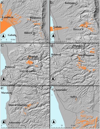
The viewsheds (Fig. 5) of most of these fortresses are comparatively limited. None of them is positioned in such a way that they can see much beyond their immediate valley. Notably, they are not inter-visible, so an optical communication system is out of the question. The fortresses were not sited according to Roman design, but rather by local actors. The matter of the specific siting of these fortresses should be sought in the rhythms of life of the people who lived in these mountains, a matter that cannot be addressed here. No evidence points to Rome trying to administer directly the region directly prior to the events of the 1030s. At least for the first half-century following Rome’s return to Syria, whatever arrangement had been made with the inhabitants of the Jabal Bahrāʿ worked, and only following the emergence of a strongman who had demonstrated his resistance to the empire on multiple occasions did the katepano take action.
Viewsheds from Jabal Bahrāʿ fortresses. a: Balāṭunus. b: Bikisrāʾīl. c: Menikos. d: Argyrokastron. e: Ḥiṣn al-Khawābī. f: Safita. Author.

Fig. 5 Long description
The maps depict viewsheds from fortresses in the Jabal Bahrāʿ region, coastal Syria. Each map uses a shaded-relief basemap with orange areas indicating visible terrain and gray for elevation. Blue represents the sea. North is oriented at the top. A) Balāṭunus: visible areas near Laodikeia and Gabala. B) Bikisrāʾīl: focuses on Gabala. C) Menikos: covers Balaneā and Argyrokastron. D) Argyrokastron: highlights surrounding terrain. E) Ḥiṣn al-Khawābī: includes Marakeš and Antarados. F) Safita: extends towards Antarados. The viewsheds cluster along ridgelines and valleys, with some extending to coastal areas.
Results and discussion
Al-Anṭākī’s account of the fortress war in the Jabal Bahrāʿ may be an unusually detailed moment of Roman frontier management, but the general outline of the story is familiar from other times and places, particularly late antiquity. Roman frontier management had a long history of empowering local leaders only to cast them or their successors down again with some regularity.Footnote 63 The prime example of where this ultimately failed was with Alaric in the fifth century; the establishment and eventual liquidation of the Jafnids in the sixth was much more successful.Footnote 64 That Roman authorities had arrested Musharraf twice suggests he was on a list of potential ‘big men’, and for whatever reason, Spondyles gambled he might be of use. Based on a seal, Musharraf had been made patrikios.Footnote 65 Presumably, this dignity came with gifts, whether cash or objects of art, which Musharraf could use to secure his rule. This had the double effect of empowering the client while also leaving them vulnerable to the continued transfer of wealth.Footnote 66 The precise timeline and the promises made are unclear, but the defeat of Romanos III outside of Aleppo provided Musharraf with the room to secure his authority in the Jabal Bahrāʿ. Other than building Menikos, we have no idea what was expected of Musharraf, although one can presume keeping the peace in the Jabal Bahrāʿ was key, as was keeping the Fatimids out.
Musharraf was appointed by the katepano, which made him a Roman client. Since we have some idea about what was expected from the other main client in the region, Aleppo, a few suppositions can be hazarded as to Musharraf’s obligations. The Treaty of Safar, however many times renegotiated since its original signing in 969, seems to have had at least some of its clauses still functioning in Mirdāsid Aleppo in the early 1030s. The original required Aleppo to provide military support and intelligence to the empire, and also to participate in the imperial customs regime.Footnote 67 It outlined the division of territory between the empire and its client, effectively granting Rome direct control over the Oinoparas valley and the Orontes as far south as Apameia.Footnote 68 Roman claims south of Shayzar were never realized, and the arrival of the Fatimids changed the situation. Yet al-Anṭākī’s mention of a tourmarches in Innab and the negotiations with the Fatimids about re-establishing Ḥassān ibn al-Muffarij in the Apameia-Shayzar area are indicative of a similar territorial arrangement with Aleppo in that region. Ibn Ṣāliḥ’s Aleppo also had to provide military support.Footnote 69 The katepano’s order to secure Jarīrīn was a test for just that.Footnote 70
Aleppo had also been prohibited from building any new fortresses.Footnote 71 The reaction to Musharraf’s construction of the fortresses suggests that the inhabitants of the Jabal Bahrāʿ were subject to a similar agreement. Just prior to these events, on the far west of the empire, the katepano of Langobardia was similarly engaged in a campaign of fortress construction, although these were on the edge of a mountain zone and none were contested by locals.Footnote 72 The location of the Syrian fortresses made them attackable from the Mediterranean roads; the danger of the inhabitants of the Jabal Bahrāʿ having fortified positions was that they thus became less vulnerable to a rapid Roman strike. The corridor analysis provides a clear visual of the accessibility of the mountain zone. Setting the fortresses and mountains into the context of the difficulty of access supports the new reading of these events presented here. Demonstrating that these fortresses were more approachable from one side of the mountains than the other allows for a more nuanced reading of the actions of all parties. While keeping Fatimid influence out of the Jabal Bahrāʿ was important, it was ultimately long-term Roman approaches to client management rather than great power competition that informed Roman actions.
Aleppo again illustrates the problem. While Aleppo’s excellent fortifications were a special case, the struggle over the city since the Roman return to Syria provided a vivid example of just how much trouble a client ensconced in a fortress could be. That Musharraf appealed to al-Dizbirī near the end of the conflict is exactly the issue: fortresses bought time for the defenders to seek out aid from other powers. This may seem an obvious point, but it connects directly to the other unique aspect of al-Anṭākī’s account of the fortress war, that of the peace process between the Romans and the Fatimids. Al-Anṭākī shows the move towards a lasting peace taking place on two levels: both Cairo and Constantinople had instructed their frontier commanders in Damascus and Antioch to sort out issues on the ground to prepare for a lasting peace, while also managing the logistics of the embassies that would eventually travel between the capitals. Notably, al-Anṭākī specifically states that the respective envoys were intended to pass through Antioch and Damascus, so as to be informed as accurately as possible of the situation in the region.Footnote 73
The truce was only arranged after the capture of Menikos, but al-Dizbirī tried to gain leverage by marching to the Orontes once Bikisrāʾīl was under siege by Niketas. Niketas did not take the bait. Al-Dizbirī also tried to call up the Banū Kilab, who did not come. Some Fatimid troops were sent in the direction of Gabala to disrupt Roman siege lines, but they were turned back, and the tourmarches of Innab made a sally and inflicted losses on the Fatimid army.Footnote 74 Al-Dizbirī’s gambit of establishing an armed and fortified semi-client in the Jabal Bahrāʿ had failed. However, al-Dizbirī’s support was little more than half-hearted. Musharraf’s pledge of loyalty to Cairo evidently put al-Dizbirī in a position where he felt that he had to provide support, and this delayed the peace process. Nonetheless, al-Dizbirī’s actions were limited to marching around threateningly, attempting to disrupt siege lines, and getting local Arabs to do the fighting for him. Even after the fall of Bikisrāʾīl, al-Anṭākī asserts that al-Dizbirī’s levying of the army was a feint intended to discourage Niketas from pushing his advantage.Footnote 75 Al-Anṭākī implies that Niketas had no such intentions, and once al-Dizbirī’s envoys reached him, the katepano began the peace process. The Fatimid general was attempting to gain negotiating leverage, not risk a major war.
The closest historical analogy might be the combined action of a Roman dux and the Persian marzban of Nisibis in the 480s, as recorded in a letter by Barsauma, metropolitan of Nisibis. Two years of famine had pushed semi-nomadic Arabs to raid across the frontier. The emperor and the shahanshah both ordered their respective frontier commanders to deal with the matter, and the marzban even entertained the dux in Nisibis.Footnote 76 Despite armies having been marshalled and treaties violated by the failure to contain the Arabs, as well as the broader Roman desire to reclaim Nisibis, the situation did not spiral into a full-scale war. Barsauma’s letters about the raiding across the Roman–Persian frontier and al-Anṭākī’s account some five and a half centuries later share a common thread in that they show snapshots of cooperation in imperial frontier management, as well as a degree of hard-headed pragmatism towards not letting local crises get out of control.Footnote 77 They also suggest that at the ground level on the frontier, even empires locked in cosmological struggle cooperated more than they fought, because keeping down locals who sought to leverage distant imperial power for their own gain was more important to maintaining the whole system of imperial extraction and rule than whatever local gains might be achieved. Clients were ultimately expendable.
The willingness of al-Dizbirī to dismiss his support for Musharraf once Bikisrāʾīl fell reveals the bigger picture of the imperial logic behind the management of the frontier in north-western Syria. The inhabitants of the region were not to get a say in this. Ḥassān ibn al-Muffarij had already demonstrated how much trouble local independent actors might cause, and it comes as no surprise that the Fatimids found the Roman proposal that he return to Syria unacceptable. Based on the least-cost corridors, Musharraf would more likely have been a problem for the Romans. However, once Rome gained the upper hand in the fortress war in the Jabal Bahrāʿ, the empires were not willing to let local actors stand in the way of peace. Rather than risking a situation analogous to late antiquity where clients could upset the status quo, the two empires opted for more direct rule. Notably, it worked: peace did not always prevail over the next half-century that Rome remained in Syria, but no large-scale hostilities broke out.
Acknowledgements
I would like to thank both peer reviewers for their helpful comments, as well as Maciej Czyż and Ksenia Ryzhova for answering many queries and the illuminating discussions that followed.

Lucas McMahon is a British Academy International Postdoctoral Fellow at the University of Exeter. His work deals with medieval Roman frontiers, foreign affairs, and information security. Recent articles have appeared in the Journal of Medieval History, Crusades, and Dumbarton Oaks Papers.



 Open access

