


Introduction: hillfort research in Slovenia
The structured use of space within European Iron Age hillforts remains poorly understood, despite a long history of intensive research (e.g. Dular & Tecco Hvala Reference Dular and Hvala2007). In Slovenia, interdisciplinary research and the integration of several multi-scalar datasets—including Airborne Laser Scanning (ALS), multi-method geophysical prospection and geochemical mapping on- and off-site and the scientific analysis of artefacts and smelting materials—are central to recent investigations of hillforts (e.g. Črešnar & Mele Reference Črešnar and Mele2019; Črešnar et al. Reference Črešnar2020). Such research has, however, offered limited insight into the identification of distinct activity areas within buildings and open spaces and in the understanding of various aspects of settlement infrastructure, including street and road systems, waste-management strategies and the spatial arrangement of land use. Closer integration of large-scale excavations with geoarchaeological research of settlement deposits has the potential to deepen our understanding of the socioeconomic structuring of hillfort space.
Archaeological research at Pungrt
The hill of Pungrt (366m above sea level), located some 10km south of the Slovenian capital of Ljubljana, rises above the small town of Ig on the southern margins of Ljubljana Marsh (Figure 1). Atop the hill, a fortified settlement was occupied from the Early Iron Age (ninth/eighth century BC) to the Early Roman Period (second century AD; Figure 2).
The Pungrt hillfort: A) location; and B) wider archaeological context with the course of the River Ižica highlighted in blue (figure by the authors; open source base maps by the Environmental Agency of the Republic of Slovenia).

Composite plan of the excavated area with detailed plans of: A) Late Hallstatt building 21; and B) Late Hallstatt building 24 (figure by P. Vojaković).

With 8800m2 of the settlement's interior uncovered, the site is the most extensively excavated hillfort in Slovenia. It is also the first with a documented proto-urban layout (Figures 2 & 3). During the development-led rescue excavation in 2020–2021, we systematically sampled well-preserved floor sequences and open-area surfaces across the settlement, collecting 200 intact micromorphology blocks and 1850 bulk samples (Figure 4).
A) Current extent of the geophysical mapping of Pungrt using ground penetrating radar (GPR) and magnetic method measurements. B) and C) show preliminary results including the outline of terraces and buildings similar to those exposed in the excavated area (figure by B. Mušič and P. Vojaković).

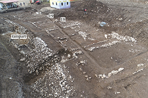
Select views of: A) the fortification system and a series of Late Hallstatt buildings lining a 55m-long stretch of gravel road 1 on the lowest terrace; B) vertical micromorphological block sampling in a 1.5m-deep section of road 1; C) horizontal micro-refuse and geochemical sampling in a 1 × 1m grid within buildings 18 and 19 (photographs by N. Ciglar and L. Gruškovnjak).

In the ongoing research project, ‘The proto-urban hillfort of Pungrt above Ig: from 10ha to 10 microns’ (2021–2024), geoarchaeological samples from buildings 21 and 24 and their associated alleys, from one of the main roads running along the inner face of the stone rampart, and from the rampart itself (Figures 2 & 4) are examined at the micro-contextual level. The integration of high-resolution geoarchaeological approaches—micromorphology (the study of microstratigraphy under a microscope), micro-refuse analysis (the study of spatial patterning of micro-artefacts and micro-debris) and geochemistry (investigation of the chemical composition of deposits)—represents a novel methodological approach within European Iron Age hillfort studies and allows us to examine many previously underexposed research themes, such as individual household organisation and settlement infrastructure.
Within the project, we aim to reconstruct the architectural choices and technological knowledge associated with the construction and maintenance of multi-phase buildings, open spaces and the multi-phase fortification system at the site. Application of our high-resolution micro-analyses also allows us to examine the activities undertaken within buildings and related outdoor areas—identifying whether they were one-time or recurring events—and to assess household organisation, discard practices and human–animal interactions. The project also incorporates research operating at larger scales, including synthesis of high-resolution ALS and multi-method geophysical and stratigraphic datasets (Figure 3), analysis of palaeobotanical and zooarchaeological remains and pottery, stone and metal artefacts and extensive and systematic radiocarbon dating of selected contexts. The ultimate objective of this comprehensive study is to profoundly improve our understanding of the long-term history of the Pungrt hillfort, its (proto-)urban characteristics and its distinct role within the wider landscape, with particular emphasis on the analysis of continuity and change in the socioeconomic structuring of space within the hillfort through time. Insights gained from this project will expand our broader understanding of household and infrastructure organisation at Iron Age hillforts and allow for comparative analyses within similar contexts across Europe.
Late Hallstatt buildings 21 and 24: preliminary geoarchaeological results
Preliminary geoarchaeological results are available for buildings 21 and 24, located on the lowest terrace of the settlement next to a 2m-wide gravel road 1 that runs along the inner face of the monumental 3m-wide stone rampart (Figure 2). Both buildings date to the Late Hallstatt period (sixth–fourth century BC) and were timber-framed with stone foundations. Each consisted of several rooms with hearths and ceramic vessels built into their floors.
Microstratigraphic analysis of building 21 reveals a stratigraphic sequence of interchanging preparation substrates and constructed floors composed of two main types: clay-rich floors made from local, decalcified subsoils; and clay-lime floor plasters. Formed by the daily activities in the building, beaten floors were also preserved in some areas, containing trampled occupational debris. Such trample-embedded micro-traces evidence periodic and quotidian activities, including the cyclical re-plastering of floor surfaces with finishing coat and the cleaning of hearth waste. In its final phase, building 21 changed from a dwelling into a stable, indicated by an organic- and phosphate-rich deposit with fragments of stabling crusts (the compacted microlayers of dung, fodder and liquid animal waste) still preserved (Figure 5).
Photomicrographs of deposits from building 21 showing: A) constructed, clay-rich floor (PPL); B) clay-lime floor plaster (XPL); C) beaten floor accruing on top of the mineral finishing coat (PPL); D) thin, red clay floor wash (PPL); E) PPL and F) XPL images of a stabling crust with the upper, highly phosphatised, and lower, organic-rich, section (figure by A. Prijatelj).

Micro-refuse analysis of building 24 is concerned with the reconstruction of recurring activities. Examining primary refuse debris (2–6mm) trampled into the floor surface allowed us to reconstruct distinct activities and the structured use of the building's interior. Most notably, micro-refuse analysis revealed that the south-western room, which would have been interpreted as a purely domestic setting based on macro-observations, was used as a blacksmith's workshop. Distribution patterns of hammerscale—micro-debris produced during the forging of iron—indicate the exact location of the smithing hearth and anvil (Figure 6), while other micro-refuse provides insights into the materials, foods, fuel and furniture used by the blacksmith.
A) Distribution density of hammerscale within building 24 and the projected location of the smithing hearth (1) based on this distribution. Circles 2 and 3 indicate ceramic vessels set into the floor. Types of hammerscale represented include: B) flakes; C) spheroids; and D) miscellaneous forms (figure by L. Gruškovnjak).

The next phase of research will see the complementary methods of micromorphology and micro-refuse analysis applied to both buildings and supplemented with additional analyses conducted through portable x-ray fluorescence, x-ray diffraction, scanning electron microscopy with energy dispersive spectroscopy and infrared spectroscopy. This will allow us to distinguish between a range of archaeological materials and deposits—and by extension the activities that produced them—that are morphologically similar at the milli- and micrometre scales, yet have different geochemical signatures. Such an approach enables the assessment of similarities and differences in earthen building materials and micro-refuse types within different households.
Conclusion
While the proto-urban hillfort of Pungrt above Ig project is ongoing, we anticipate that the multi-method and multi-scalar approach to the vast corpus of geoarchaeological data from the site will allow us to reconstruct distinct socioeconomic biographies of buildings, open spaces and the fortification system at the site. The integrated analysis of microstratigraphic sequences, micro-refuse and geochemical signals within settlement deposits will make important contributions to our understanding of the functional structuring of space within individual households, as well as the technological knowledge associated with building and craft activities, human–animal interactions, and discard and sanitation practices at the site. The interweaving of these various strands of evidence will, in turn, create a more holistic picture of the synchronic and diachronic household and community practices that contributed to the emergence of the economic, social and cultural space of the long-lived Pungrt hillfort.
Funding statement
We thank the Slovenian Research and Innovation Agency for funding this research (grant number J6-3126 to MČ).


